Suō-Ōshima
This article includes a list of references, related reading or external links, but its sources remain unclear because it lacks inline citations. (February 2019) |
Suō-Ōshima
周防大島町 | |
|---|---|
Town | |
 Suō-Ōshima town hall | |
 Flag  Seal | |
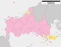 Location of Suō-Ōshima in Yamaguchi Prefecture | |
 Suō-Ōshima Location in Japan | |
| Coordinates: 33°55′N 132°14′E / 33.917°N 132.233°ECoordinates: 33°55′N 132°14′E / 33.917°N 132.233°E | |
| Country | Japan |
| Region | Chūgoku San'yō |
| Prefecture | Yamaguchi Prefecture |
| District | Ōshima |
| Government | |
| • Mayor | |
| Area | |
| • Total | 138.17 km2 (53.35 sq mi) |
| Population (May 2008) | |
| • Total | 20,163 |
| • Density | 146/km2 (380/sq mi) |
| Time zone | UTC+09:00 (JST) |
| City hall address | 126-2, Ōaza Komatsu, Suō-Ōshima-chō, Ōshima-gun, Yamaguchi-ken 742-2192 |
| Website | www |
| Symbols | |
| Flower | Mikan |
| Tree | Mikan |

Suō-Ōshima (周防大島町, Suō-Ōshima-chō) is a town and an island located in Ōshima District, Yamaguchi Prefecture, Japan.
Suō-Ōshima was formed on October 1, 2004 from the merger of the former towns of Ōshima, Kuka, Tachibana and Tōwa, all from towns of Ōshima District.
As of April 1, 2017, the town has an estimated population of 17,030. The total area is 138.17 km².
Suo-Oshima has established a sister island relationship with the County of Kauai, Hawaii in 1963. A 50th Anniversary commemoration was held on Kauai in October 2013. Current Mayors Takumi Shiiki (Suo-Oshima) and Bernard P. Carvalho, Jr. (Kauai) signed a Reaffirmation of Friendship agreement.
Schools in Suo-Oshima:
Oshima Shosen, Suo-Oshima High School
Junior High Schools: Towa JHS, Kuka JHS, Agenosho JHS, Oshima JHS
Elementary Schools: Yuda ES, Morino ES, Joyama ES, Kuka ES, Agenosho ES, Shimanaka ES, Meishin ES, Migama ES, Okiura ES
External links[]
- Suō-Ōshima official website (in Japanese)
- Instagram #Suo-Oshima
- Setouchifinder
- Setouchifinder(in Japanese)
- Kauai news (in English)
- Oshima Shosen students visit Kauai (in English)
- Museum of Japanese Emigration to Hawaii (in English)
| show Authority control |
|---|
This article about a location in Yamaguchi Prefecture is a stub. You can help Wikipedia by . |
- Towns in Yamaguchi Prefecture
- Islands of the Seto Inland Sea
- Islands of Yamaguchi Prefecture
- Yamaguchi geography stubs