Historic Areas of Istanbul
| UNESCO World Heritage Site | |
|---|---|
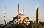
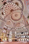
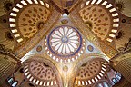
 From left to right: The Sultan Ahmed Mosque; the Hagia Sophia; the Seraglio Point consisting of the Topkapı Palace and the Sea Walls; and the Galata Tower at far right, across the Golden Horn. | |
| Location | Istanbul, Turkey |
| Includes |
|
| Criteria | Cultural: (i), (ii), (iii), (iv) |
| Reference | 356bis |
| Inscription | 1985 (9th Session) |
| Extensions | 2017 |
| Area | 765.5 ha (1,892 acres) |
| Coordinates | 41°0′30.49″N 28°58′47.75″E / 41.0084694°N 28.9799306°ECoordinates: 41°0′30.49″N 28°58′47.75″E / 41.0084694°N 28.9799306°E |
 Location of Historic Areas of Istanbul in Turkey | |

The Historic Areas of Istanbul are a group of sites in the capital district of Fatih in the city of Istanbul, Turkey. These areas were added to the UNESCO World Heritage List in 1985.
This World Heritage Site includes buildings and structures such as the Sarayburnu, the Topkapı Palace, the Hagia Sophia, the Sultan Ahmed Mosque, the Hagia Irene, Zeyrek Mosque, Süleymaniye Mosque, Little Hagia Sophia and the Walls of Constantinople.
Zones[]
The World Heritage site covers four zones, illustrating the major phases of the city's history using its most prestigious monuments:
- the Archaeological Park, which in 1953 and 1956 was defined at the tip of the peninsula;
- the Süleymaniye quarter, protected in 1980 and 1981;
- the Zeyrek quarter, protected in 1979;
- the zone of the ramparts, protected in 1981.
Gallery[]


| Neighbourhoods |
|
|---|---|
| Quarters | |
| Landmarks | |
| Transport | |
| Education | |
| |
| Aegean | |
|---|---|
| Black Sea | |
| Central Anatolia | |
| East Anatolia | |
| Marmara | |
| Mediterranean | |
| Southeastern Anatolia | |
| |
This geographical article about a location in Istanbul Province, Turkey is a stub. You can help Wikipedia by . |
Categories:
- World Heritage Sites in Turkey
- History of Istanbul
- Istanbul Province geography stubs