Hollywood Boulevard
This article needs additional citations for verification. (May 2009) |
 Hollywood Blvd sign | |||
| Former name(s) | Prospect Avenue (1887–1910) | ||
|---|---|---|---|
| Maintained by | Bureau of Street Services, City of L.A. DPW | ||
| Nearest metro station | |||
| West end | Sunset Plaza Drive in Hollywood Hills West | ||
| Major junctions |
Highland Avenue in Hollywood Vine Avenue in Hollywood Western Avenue in Hollywood Normandie Avenue in Hollywood Vermont Avenue in Los Feliz | ||
| East end | Sunset Boulevard/Hillhurst Avenue/Virgil Avenue in Los Feliz | ||
| Other | |||
| Known for |
Hollywood and Vine Hollywood Walk of Fame | ||
Hollywood Boulevard Commercial and Entertainment District | |||
U.S. National Register of Historic Places | |||
U.S. Historic district | |||
 The revamped Hollywood Boulevard as seen from the Dolby Theatre | |||
| Built | 1939 | ||
| NRHP reference No. | 85000704 | ||
| Added to NRHP | April 4, 1985 | ||
Hollywood Boulevard is a major east–west street in Los Angeles, California. It begins in the west as a winding residential street at Sunset Plaza Drive in the Hollywood Hills West district. After crossing Laurel Canyon Boulevard, it proceeds due east as a major thoroughfare through Hollywood, Little Armenia and Thai Town to Vermont Avenue. It then runs southeast to its eastern terminus at Sunset Boulevard in the Los Feliz district. Parts of the boulevard are popular tourist destinations, primarily the fifteen blocks between La Brea Avenue east to Gower Street where the Hollywood Walk of Fame is primarily located.
History[]
Hollywood Boulevard was originally named Prospect Avenue until 1910, when the town of Hollywood, created by H.J. Whitley, was annexed by the neighboring city of Los Angeles. After annexation, the street numbers changed from 100 Prospect Avenue, at Vermont Avenue, to 4600 Hollywood Boulevard.
1920s[]
In the early 1920s, real estate developer Charles E. Toberman (the "Father of Hollywood") envisioned a thriving Hollywood theatre district.[1] Toberman was involved in 36 projects while building the Max Factor Building, Hollywood Roosevelt Hotel and the Hollywood Masonic Temple. With Sid Grauman, he opened the three themed theatres: Egyptian, El Capitan ("The Captain") (1926), and Chinese.[2]
Regional shopping district[]
In the 1920s the Boulevard and adjacent streets became a major regional shopping district, both for everyday needs and appliances, but increasingly also for high-end clothing and accessories, in part because of the nearby film studios. Chains that opened includes Schwab's in 1921, Mullen & Bluett in 1922, I. Magnin in 1923, Myer Siegel in 1925, F. W. Grand and Newberry's (dime stores) in 1926-8, and Roos Brothers in 1929. The independent Robertson's department store, at 46,000 square feet (4,300 m2) and 4 stories tall, opened in 1923. In 1922, stock was sold to finance construction of a much larger department store at Hollywood and Vine,[3] originally to have been a Boadway Bros.. When Boadway's went out of business the next year, B. H. Dyas, a Downtown Los Angeles-based department store,[4] opened in the 130,000-square-foot (12,000 m2) building in March 1928, then sold their lease to The Broadway in 1931 – the building still a landmark today, known as the Broadway Hollywood Building. By 1930 the shopping district consisted of over 300 stores.[5] The area would later face competition from areas along Wilshire Boulevard: the easternmost around Bullocks Wilshire which opened in 1929, second the Miracle Mile, and finally, the shopping district of Beverly Hills, where Saks Fifth Avenue opened a store in 1938.
1940s–1960s[]
In 1946, Gene Autry, while riding his horse in the Hollywood Christmas Parade — which passes down Hollywood Boulevard each year on the Sunday after Thanksgiving — heard young parade watchers yelling, "Here comes Santa Claus, here comes Santa Claus!" and was inspired to write "Here Comes Santa Claus" with Oakley Haldeman.[6]
In 1958, the Hollywood Walk of Fame, which runs from La Brea Avenue east to Gower Street (and an additional three blocks on Vine Street), was created as a tribute to artists working in the entertainment industry.
Decline[]
In the 1970s, the street became very seedy and was frequented by many odd characters as shown in pictures by photographer Ave Pildas.[7]
Revitalization[]
In 1985, a portion of Hollywood Boulevard in Hollywood was listed in the National Register of Historic Places as part of the "Hollywood Boulevard Commercial and Entertainment District". In 1992, the street was paved with glittery asphalt between Vine Street and La Brea Boulevard.[8]
The El Capitan Theatre was refurbished in 1991 then damaged in the 1994 Northridge earthquake. The full El Capitan building was fully restored and upgraded in December 1997. The Hollywood Entertainment District, a self-taxing business improvement district, was formed for the properties from La Brea to McCadden on the boulevard.[2]
The Hollywood extension of the Metro Red Line subway was opened in June 1999, running from Downtown Los Angeles to the San Fernando Valley. Stops on Hollywood Boulevard are located at Western Avenue, Vine Street, and Highland Avenue. Metro Local lines 180 and 217 also serve Hollywood Boulevard. A Light Rail extension station is proposed at the Hollywood Blvd. and Highland Ave. intersection connection the boulevard with West Hollywood, Central LA and LAX.
An anti-cruising ordinance prohibits driving on parts of the boulevard more than twice in four hours.[9]
Beginning in 1995, then Los Angeles City Council member Jackie Goldberg initiated efforts to clean up Hollywood Boulevard and reverse its decades-long slide into disrepute.[10] Central to these efforts was the construction of the Hollywood and Highland Center and adjacent Dolby Theatre (originally known as the Kodak Theater) in 2001.
In early 2006, the city made revamping plans on Hollywood Boulevard for future tourists. The three-part plan was to exchange the original streetlights with red stars into two-headed old-fashioned streetlights, put in new palm trees, and put in new stoplights. The renovations were completed in late 2006.
In the few years leading up to 2007, more than $2 billion was spent on projects in the neighborhood, including mixed-use retail and apartment complexes and new schools and museums.[10]
Advocates promote the idea of closing Hollywood Boulevard to traffic and create a Pedestrian zone from La Brea Avenue to Highland Avenue citing an increase in pedestrian traffic including tourism, weekly movie premiers[11] and award shows closures, including 10 days for the Academy Award ceremony at the Dolby Theater.[12] Similar to other cities in the US, like Third Street Promenade, Fremont Street in Las Vegas, Market St. in San Francisco or the closure in Times Squares Pedestrian Plaza's created in 2015.[13]
In June 2019, The City of Los Angeles commissioned Gensler architects to provide a master plan for a $4 million dollar renovation to improve and "update the streetscape concept" for the Walk of Fame.[14][15][16] Los Angeles City Councilmember Mitch O’Farrell released the draft master plan designed by Gensler and Studio-MLA in January 2020. It proposed widening the sidewalks, adding bike lanes, new landscaping, sidewalk dining, removing lanes of car traffic and street parking between the Pantages Theater (Argyle Avenue) at the east and (La Brea Avenue) at the west end of the boulevard.[17]
Gallery[]

The intersection of Hollywood, then named Prospect and Highland avenues 1907

Cruising circa 1909

View toward the intersection of Hollywood and Highland, 2006

Hollywood Blvd at night
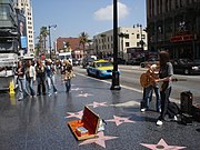
Hollywood Walk of Fame


Events[]
A popular event that takes place on the Boulevard is the complete transformation of the street to a Christmas theme. Shops and department stores attract customers by lighting their stores and the entire street with decorated Christmas trees and Christmas lights. The street essentially becomes "Santa Claus Lane."[18]
Landmarks[]

- American Cinematheque
- Barnsdall Art Park
- Bob Hope Square (Hollywood and Vine)
- Broadway Hollywood Building
- Capitol Records Tower
- Chinese Theatre
- Dolby Theatre
- Grauman's Egyptian Theatre
- El Capitan Theatre
- Fonda Theatre
- Frederick's of Hollywood
- Hollywood Sign
- Hollywood and Highland
- Hollywood Pacific Theatre
- Hollywood Roosevelt Hotel
- Hollywood Walk of Fame
- Hollywood Wax Museum
- Hollywood Masonic Temple
- Madame Tussauds Hollywood
- Musso & Frank Grill
- Pantages Theatre
- Ripley's Believe It Or Not! Odditorium
- Vista Theatre
See also[]
References[]
- ^ Lord, Rosemary (2002). Los Angeles: Then and Now. San Diego, CA: Thunder Bay Press. pp. 90–91. ISBN 1-57145-794-1.
- ^ a b Vaughn, Susan (March 3, 1998). "El Capitan Courageous". Los Angeles Times. Retrieved September 7, 2015.
- ^ "Advertisement for Boadway Bros., Inc". Holly Leaves (magazine). July 1, 1922. p. 37. Retrieved July 13, 2020.
- ^ Williams, Gregory Paul. The Story of Hollywood. p. 233.
- ^ Longstreth, Richard (1997). City Center to Regional Mall. MIT Press. pp. 84–86. ISBN 0262122006.
- ^ "Home – The Hollywood Christmas Parade." The Hollywood Christmas Parade. N.p., n.d. Web. 23 May 2014.
- ^ MacLaren, Becca (17 July 2015). "The Seedy, Funky, and Fabulous Hollywood Boulevard of the 1970s". The Getty Iris. The Getty. Retrieved 23 January 2020.
- ^ Krikorian, Greg (September 5, 1992). "Hollywood Blvd. to Be Paved With Glitz". Los Angeles Times. Retrieved December 12, 2018.
- ^ Martin H and McCormack S (September 24, 1999): Idled by the Law : As Cities Crack Down on Cruising, Car Culture Aficionados Find Other Outlets. Los Angeles Times archive. Retrieved March 26, 2013.
- ^ a b Steinhauer, Jennifer (January 26, 2007). "Development at Hollywood Boulevard and Vine Street spurs Tinseltown renaissance". International Herald Tribune. Retrieved August 14, 2012.
- ^ "Alerts Archive". Only In Hollywood. Retrieved 2020-01-31.
- ^ Walker, Alissa (2 March 2018). "Make the Oscars street closures permanent". Curbed LA.
- ^ Crotty, Emilia (2015-12-30). "Opinion: Here's a New Year's resolution worth keeping: Close Hollywood Boulevard to cars in 2016". Los Angeles Times. Retrieved 2020-01-31.
- ^ "Hollywood Walk of Fame's $4-Million Master Plan Moves Forward". Urbanize LA. 2019-06-14. Retrieved 2020-01-31.
- ^ "Hollywood Walk of Fame Update Coming, City Selects Firm to Design Improvements". NBC Los Angeles. Retrieved 2020-01-31.
- ^ Nelson, Laura J.; Vega, Priscella (2020-01-30). "L.A. considers bold makeover for Hollywood Boulevard: Fewer cars, bike lanes, wider sidewalks". Los Angeles Times. Retrieved 2020-01-31.
- ^ Barragan, Bianca (2020-01-31). "'Exciting' Hollywood Boulevard makeover unveiled. But don't call it radical". Curbed LA. Retrieved 2020-03-05.
- ^ Masters, Nathan. "When Hollywood Boulevard Became Santa Claus Lane" | LA as Subject | SoCal Focus | KCET." KCET. N.p., n.d. Web. 23 May 2014.
External links[]
| Wikimedia Commons has media related to Hollywood Boulevard, Hollywood. |
Route map:

| ( • help)
|
| Wikiquote has quotations related to: Hollywood Boulevard |
Greater Hollywood | ||
|---|---|---|
| Districts and neighborhoods |
|  |
| Points of interest |
| |
| Neighboring cities and communities |
| |
| ||
- Hollywood Boulevard
- Streets in Hollywood
- Streets in Los Angeles
- Boulevards in the United States
- East Hollywood, Los Angeles
- Hollywood history and culture
- Historic districts in Los Angeles
- Historic districts on the National Register of Historic Places in California
- National Register of Historic Places in Los Angeles
- Streets in Los Angeles County, California
- Roads on the National Register of Historic Places in California
- Former shopping districts and streets in Los Angeles