Victory Boulevard (Los Angeles)
| Namesake | To honor soldiers returning from World War I[1] | ||
|---|---|---|---|
| Maintained by | Bureau of Street Services, City of L.A. DPW, City of Burbank, City of Glendale | ||
| West end | Upper Las Virgenes Canyon Open Space Preserve | ||
| Major junctions |
Topanga Canyon Blvd. in Canoga Park Reseda Blvd. in Reseda Balboa Blvd. in Van Nuys Sepulveda Blvd. in Van Nuys Van Nuys Blvd. in Van Nuys Vineland Ave. in N. Hollywood W. Burbank Blvd. in Burbank W. Alameda Ave. in Burbank Western Ave. in Glendale | ||
| East end |
| ||
Victory Boulevard is a major east-west arterial road that runs 25 miles (40 km) traversing the entire length of the San Fernando Valley in Los Angeles County, Southern California, United States.
Geography[]
Victory Boulevard is approximately 25 miles (40 km) long, and is notable for several reasons. Victory Boulevard is the street where one will find the West Valley's major malls at Fallbrook Center and Westfield Topanga, through the Warner Center business district, along a section of the Metro G Line and by three of its stations, past Pierce College, through the with Lake Balboa, Pedlow Skate Park and golf courses, then through the communities of Van Nuys, Valley Glen and North Hollywood in the center of the valley, crossing the Tujunga Wash, and continuing past Valhalla Memorial Park Cemetery with its Portal of the Folded Wing, through Burbank's entertainment district, passing the Nickelodeon studios at Olive Avenue, then veering southeast to its eastern terminus at Griffith Park near the Los Angeles Zoo and Travel Town Museum (at the intersection of Riverside Drive & Sonora Avenue).
Victory Boulevard is one of three Los Angeles boulevards included in the lyrics of Randy Newman's song "I Love L.A.": "...Century Boulevard (We Love It!), Victory Boulevard (We Love It), Santa Monica Boulevard (We Love It)..."[2]
History[]

When Van Nuys was plotted in 1911, Victory Boulevard was called 7th Avenue.[3] Around 1916, the name was changed to Leesdale Avenue when the city of Los Angeles annexed the San Fernando Valley after the Los Angeles Aqueduct was completed.[3] In the mid-1920s, the Leesdale Improvement Association unveiled plans to expand Leesdale Avenue as an 80-foot (24 m)-wide "great east-and-west boulevard" through the Valley.[3] At that time, the City also changed the name to Victory Boulevard, in honor of soldiers returning from World War I,[1] and paved the boulevard as far west as Balboa Boulevard where it ended.[3] Victory Boulevard did not extend to the West Valley until the 1950s.[3][4]
Transportation[]
The Metro Local Lines 96 and 164 runs along Victory Boulevard.
Communities (west to east)[]
- West Hills – west of Shoup Avenue to the Victory Trailhead entrance of Ahmanson Ranch Park in the Simi Hills, Victory Boulevard marks the southern border of West Hills and northern border of adjacent Woodland Hills.
- Woodland Hills – between the western city limits, and Corbin Avenue on the east, Victory Boulevard marks the northern border of Woodland Hills, with West Hills, Canoga Park, and Winnetka to the north.
- Canoga Park – Victory Boulevard marks the southern border of Canoga Park between Shoup, and DeSoto, with Woodland Hills to the south
- Winnetka – DeSoto Avenue is the western boundary, Corbin Avenue is the eastern boundary, with the Los Angeles River and Woodland Hills to the south.
- Reseda – Victory Boulevard marks the southern border of Reseda between Corbin Avenue and White Oak Avenue, with Tarzana to the south..
- Tarzana – Victory Boulevard marks the northern border of Tarzana between Corbin Avenue (west) and Lindley Avenue (east)[5]
- Lake Balboa – between White Oak and I-405 (the San Diego Freeway)
- Encino – Victory Boulevard marks the northern border of Encino between Lindley Avenue and White Oak
- Van Nuys – between I-405 (the San Diego Freeway) and Hazeltine Avenue
- Valley Glen – between Hazeltine Avenue and CA 170 (the Hollywood Freeway)[6]
- North Hollywood – between CA 170 (the Hollywood Freeway) and Clybourn Avenue
- Burbank – between Clybourn Avenue and Allen Avenue
- Glendale – between Allen Avenue and Riverside Drive/Sonora Avenue
Notable landmarks (west to east)[]
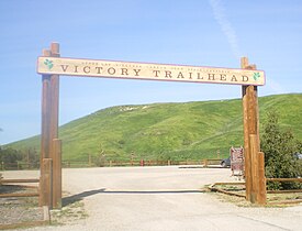
- Upper Las Virgenes Canyon Open Space Preserve (formerly Ahmanson Ranch)— a 3,000-acre (1,200 ha) public nature preserve park of the Santa Monica Mountains Conservancy, located at the western terminus of Victory Boulevard near the West Hills—Woodland Hills boundary.[7]
- Fallbrook Center – 75-acre (300,000 m2), 1-million-square-foot (93,000 m2), open-air shopping center located at Victory Boulevard and Fallbrook Avenue in West Hills; retailers including Kohl's, Home Depot, Target, Trader Joe's, Sprouts Farmers Market, Ross, Michael's Arts & Crafts, Designer Shoe Warehouse, Petco, and Fallbrook AMC Theatres.[8]
- Westfield Topanga – opened in 1964 as Topanga Plaza, California's first enclosed shopping mall, and located on Topanga Canyon Boulevard at Victory Boulevard, Westfield Topanga was extensively renovated from 2006–2008 and features 230 stores including Macy's, Nordstrom, Neiman Marcus, Target, and Apple Store.[9]
- Los Angeles Pierce College – opened in 1947 as an agricultural college and the San Fernando Valley's first institution of higher learning, Pierce College today is a two-year public college with almost 100 disciplines and 20,000 students, located on 426 acres (172 ha) in the Chalk Hills, with 2,200 trees, thousands of rose bushes, a nature preserve, botanical garden, and a forest area boasting giant redwoods; Pierce still maintains large sections of tillable and range land and a 226-acre (91 ha) farm at the west side of campus, with an equestrian center and small herds of cattle, sheep and goats.[10]
- Reseda High School – a public high school in the Los Angeles Unified School District established in 1955; used as the setting for the high school in The Shield, several episodes of Buffy the Vampire Slayer and in the feature film Grosse Pointe Blank.
- Sherman Oaks Center for Enriched Studies – located in Tarzana, SOCES is the largest magnet school in the Los Angeles Unified School District, 1780 students in grades 4–12; #1 High School API test score in LAUSD.[11]

- Birmingham High School, Lake Balboa – built in 1953 on the site of a U.S. Army hospital; from 1976–1979, the San Fernando Valley's first professional sports team, the Los Angeles Skyhawks of the American Soccer League, played their home games at Birmingham Stadium on Victory Boulevard.[12] In May 1967, a rock concert at the football field at Birmingham High featured Jefferson Airplane, The Doors, The Merry-Go-Round, The Peanut Butter Conspiracy, The Sunshine Company, and the Nitty Gritty Dirt Band.[13]
- Lake Balboa – a 27-acre (11 ha) lake south of Victory Boulevard filled with water reclaimed from the Tillman Water Reclamation Plant featuring fishing, boating, remote-control boating and jogging/walking.[14]
- Valley Plaza shopping center along Victory and Laurel Canyon Boulevards, opened in 1951 and by 1956 it claimed to cover 100 acres with 1,039,000 square feet of retail space, the third-largest in the nation at that time[15][16]
- Valhalla Memorial Park Cemetery, North Hollywood – cemetery founded in 1923; the Portal of the Folded Wings, a tribute to the pioneers of aviation, is on the National Register of Historic Places; Valhalla is the burial site of many aviation pioneers and early Hollywood celebrities.[17]
- Griffith Park – located at the eastern terminus of Victory Boulevard, Griffith Park is LA's largest park covering 4,210 acres (1,700 ha) with attractions including the Autry National Center, Greek Theatre, Griffith Observatory, L.A. Equestrian Center, Los Angeles Zoo, and Travel Town[18]
Gallery of landmarks[]

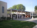
Pierce College, Woodland Hills

Sherman Oaks Center for Enriched Studies
Reseda High School

Los Angeles River at Victory and White Oak
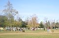
Sepulveda Off-Leash Dog Park

Lake Balboa

Tonga Hut in North Hollywood

Tujunga Wash

Street Scene in Burbank

Nickelodeon Studios, Burbank
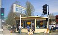
Corner Cottage Beef Bowl, Burbank


References[]
- ^ a b Roderick, Kevin (2001). The San Fernando Valley: America's Suburb. Los Angeles Times Books. ISBN 188379255X.
- ^ Courrier, Kevin (2005). Randy Newman's American Dreams. ECW Press. p. 246. ISBN 9781550226904.
- ^ a b c d e "The Valley Observed: How Leesdale became Victory Boulevard". Archived from the original on 2012-11-10. Retrieved 2015-04-01.
- ^ "How Leesdale became Victory Blvd". The Valley Observed - archived. Archived from the original on November 10, 2012. Retrieved 1 April 2015.
- ^ "Tarzana Neighborhood Council: Tarzana Boundary Map". Tarzananc.org. Retrieved 13 August 2019.
- ^ "Valley Glen Map". Valleyglen.org. Retrieved 13 August 2019.
- ^ "LA Mountains: Upper Las Virgenes Canyon Open Space Preserve (formerly Ahmanson Ranch)". Lamountains.com.
- ^ "Southwest USA Shopping Center+". Sw.officialsite.com. Retrieved August 13, 2019.
- ^ "Westfield Topanga & The Village". Westfield.com. Retrieved August 13, 2019.
- ^ "Los Angeles Pierce College". Piercecollege.edu. Retrieved August 13, 2019.
- ^ "Archived copy". soces.lausd.k12.ca.us. Archived from the original on 23 April 2007. Retrieved 17 January 2022.
{{cite web}}: CS1 maint: archived copy as title (link) - ^ [1][dead link]
- ^ "Rock Show at Birmingham". Archived from the original on 2008-03-03. Retrieved 2008-03-18.
- ^ "Archived copy". www.laparks.org. Archived from the original on 13 December 2004. Retrieved 17 January 2022.
{{cite web}}: CS1 maint: archived copy as title (link) - ^ Esquivel, Ralph (May 1, 1956). "Survey of Sales Reveals Record by Valley Plaza". Valley Times (North Hollywood, CA).
- ^ "Advertisement for Valley Plaza". Los Angeles Times. April 29, 1960.
- ^ Pierce Brothers Valhalla Memorial Park: Famous names at Find a Grave
- ^ "Griffith Park". Archived from the original on 2005-02-16.
| Wikimedia Commons has media related to Victory Boulevard (Los Angeles). |
Route map:

| ( • help)
|
- Streets in the San Fernando Valley
- Streets in Los Angeles
- Streets in Los Angeles County, California
- Boulevards in the United States
- Burbank, California
- Canoga Park, Los Angeles
- Encino, Los Angeles
- Glendale, California
- Lake Balboa, Los Angeles
- North Hollywood, Los Angeles
- Reseda, Los Angeles
- Tarzana, Los Angeles
- Van Nuys, Los Angeles
- West Hills, Los Angeles
- Winnetka, Los Angeles
- Woodland Hills, Los Angeles