Honningsvåg
Honningsvåg Northern Sami: Honnesváhki | |
|---|---|
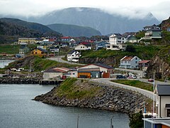
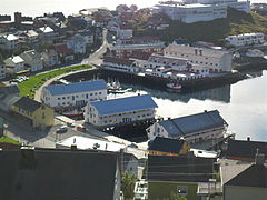
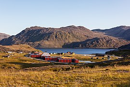
 View of the town | |
 Honningsvåg Northern Sami: Honnesváhki Location of the town | |
| Coordinates: 70°58′43″N 25°58′36″E / 70.97861°N 25.97667°ECoordinates: 70°58′43″N 25°58′36″E / 70.97861°N 25.97667°E | |
| Country | Norway |
| Region | Northern Norway |
| County | Troms og Finnmark |
| District | Vest-Finnmark |
| Municipality | Nordkapp Municipality |
| Area | |
| • Total | 1.05 km2 (0.41 sq mi) |
| Elevation | 12 m (39 ft) |
| Population (2017)[1] | |
| • Total | 2,484 |
| • Density | 2,366/km2 (6,130/sq mi) |
| Time zone | UTC+01:00 (CET) |
| • Summer (DST) | UTC+02:00 (CEST) |
| Post Code | 9750 Honningsvåg |


![]() Honningsvåg (help·info) is the northernmost town in mainland Norway. It is located in Nordkapp Municipality in Troms og Finnmark county. Legislation effective in 1997 states that a Norwegian city/town (same word in Norwegian) must have at least 5,000 inhabitants, but Honningsvåg was declared a city in 1996, thus exempt from this legislation, so it is also one of the smallest cities in Norway. The 1.05-square-kilometre (260-acre) town has a population (2017) of 2,484 which gives the town a population density of 2,366 inhabitants per square kilometre (6,130/sq mi).[1]
Honningsvåg (help·info) is the northernmost town in mainland Norway. It is located in Nordkapp Municipality in Troms og Finnmark county. Legislation effective in 1997 states that a Norwegian city/town (same word in Norwegian) must have at least 5,000 inhabitants, but Honningsvåg was declared a city in 1996, thus exempt from this legislation, so it is also one of the smallest cities in Norway. The 1.05-square-kilometre (260-acre) town has a population (2017) of 2,484 which gives the town a population density of 2,366 inhabitants per square kilometre (6,130/sq mi).[1]
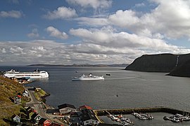
Honningsvåg is situated at a bay on the southeastern side of the large island of Magerøya, while the famous North Cape and its visitor center is on the northern side of the island. Honningsvåg is a port of call for cruise ships, especially in the summer months. The ice-free ocean (the southwestern part of the Barents Sea) provides rich fisheries and tourism is also important to the town. Even at 71°N, many private gardens in Honningsvåg have trees, although rarely more than 3 to 4 metres (9.8 to 13.1 ft) tall.[3]
The famous dog Bamse came from Honningsvåg.
Transportation[]
Honningsvåg is one of the main stops of the Hurtigruten coastal ships on their lengthy route along the Norwegian coast between Kirkenes in the north and Bergen in the south. The northbound ships to Kirkenes dock in the port from 11:15 to 14:45, generating heavy tourist activity in the city. The southbound ships to Bergen make a short stop around 05:30.
Honningsvåg Airport, Valan, located 4 kilometres (2.5 mi) north of the town, provides flights mainly to Tromsø, with connecting flights to Oslo.
History[]

The area was first settled in prehistory, as early as 10,300 years ago. The sea was probably the main food source.
City status[]
Honningsvåg was declared a town in 1996 by the municipal council of Nordkapp. National legislation was passed in 1997 that states that a Norwegian city must have at least 5,000 inhabitants, but since Honningsvåg was declared a city in 1996, it was exempt from this legislation. This makes it one of the smallest cities in Norway.
Name[]
The Old Norse form of the name was probably Hornungsvágr. The first element is then the genitive case of the (hypothetical) name of a mountain, Hornungr, which has since fallen into disuse. Hornungr could have been an older name of mount Storefjell (literally "big mountain"), a tall and hornlike peak near Honningsvåg, which would imply that the name was derived from the word horn. The last element is vágr, which means "bay". The full name thus means "the bay lying beneath the mountain Hornungr."[4]
Notable people[]
Media gallery[]


Climate[]
Even though Honningsvåg is located at the northernmost extreme of Europe, it has a subarctic climate, thanks to the Gulf Stream. Also, there is no permafrost because the mean annual temperature is 2 °C (36 °F). The July 24-hour average temperature is just over 10 °C (50 °F). Weather in winter is softened by the ice-free ocean, and the average temperature is not as low as that of most other locations around this latitude. In fact, winters at Honningsvåg are warmer than those of Oslo Airport which is located 1,400 kilometres (870 mi) to the southwest and eleven degrees of latitude farther from the north pole. Summers are cool and short. Mean annual precipitation is 765 millimetres (30.1 in). The wettest months are from October to January, with 85 millimetres (3.3 in) average precipitation per month, while the driest months are from May to July, with 43 millimetres (1.7 in) average precipitation per month.[5] The sun is up for 24 hours per day between 13 May and 31 July, and remains below the horizon continuously from 21 November to 21 January. On December 29, 2008, winds were recorded at 81 mph.[citation needed]
| hideClimate data for Honningsvåg, extremes 1984-present | |||||||||||||
|---|---|---|---|---|---|---|---|---|---|---|---|---|---|
| Month | Jan | Feb | Mar | Apr | May | Jun | Jul | Aug | Sep | Oct | Nov | Dec | Year |
| Record high °C (°F) | 9.0 (48.2) |
9.5 (49.1) |
7.4 (45.3) |
12.5 (54.5) |
18.8 (65.8) |
25.0 (77.0) |
27.0 (80.6) |
24.0 (75.2) |
19.0 (66.2) |
13.0 (55.4) |
9.0 (48.2) |
7.1 (44.8) |
27.0 (80.6) |
| Average high °C (°F) | −2 (28) |
−2 (28) |
0 (32) |
3 (37) |
7 (45) |
11 (52) |
15 (59) |
13 (55) |
9 (48) |
4 (39) |
1 (34) |
−1 (30) |
4.8 (40.6) |
| Daily mean °C (°F) | −4.5 (23.9) |
−4.5 (23.9) |
−3.1 (26.4) |
−0.6 (30.9) |
3.4 (38.1) |
7.2 (45.0) |
10.3 (50.5) |
10.0 (50.0) |
6.9 (44.4) |
2.6 (36.7) |
−0.8 (30.6) |
−3.3 (26.1) |
2 (36) |
| Average low °C (°F) | −13 (9) |
−12 (10) |
−10 (14) |
−6 (21) |
−1 (30) |
3 (37) |
5 (41) |
5 (41) |
3 (37) |
−2 (28) |
−7 (19) |
−11 (12) |
−3.8 (25.2) |
| Record low °C (°F) | −19.0 (−2.2) |
−17.2 (1.0) |
−14.0 (6.8) |
−11.0 (12.2) |
−6.0 (21.2) |
−1.0 (30.2) |
3.0 (37.4) |
3.0 (37.4) |
−2.0 (28.4) |
−7.0 (19.4) |
−11.0 (12.2) |
−12.0 (10.4) |
−19.0 (−2.2) |
| Average precipitation mm (inches) | 86 (3.4) |
69 (2.7) |
62 (2.4) |
54 (2.1) |
41 (1.6) |
42 (1.7) |
45 (1.8) |
52 (2.0) |
62 (2.4) |
83 (3.3) |
77 (3.0) |
92 (3.6) |
765 (30.1) |
| Average precipitation days (≥ 1.0 mm) | 26 | 23 | 21 | 19 | 16 | 16 | 15 | 17 | 20 | 24 | 24 | 26 | 247 |
| Mean daily sunshine hours | 0 | 1 | 2 | 5 | 7 | 7 | 8 | 5 | 3 | 1 | 0 | 0 | 3 |
| Source 1: Norwegian Meteorological Institute[6] | |||||||||||||
| Source 2: Weather2Travel.com[5] and Infoclimat.fr (extremes)[7] | |||||||||||||
See also[]
References[]
- ^ Jump up to: a b c Statistisk sentralbyrå (1 January 2017). "Urban settlements. Population and area, by municipality".
- ^ "Honningsvåg" (in Norwegian). yr.no. Retrieved 14 February 2013.
- ^ "Norway - Honningsvag Vacations". Solar Tours. Archived from the original on 30 March 2012. Retrieved 15 August 2011.
- ^ Rygh, Oluf (1924). Norske gaardnavne: Finmarkens amt (in Norwegian) (18 ed.). Kristiania, Norge: W. C. Fabritius & sønners bogtrikkeri. p. 171.
- ^ Jump up to: a b "Honningsvåg Climate Guide". World Climate Guide. Retrieved 15 February 2013.
- ^ "eKlima Web Portal". Norwegian Meteorological Institute. Archived from the original on 14 June 2004.
- ^ "Normales et records climatologiques 1981-2010 à Honningsvag / Valan - Infoclimat". www.infoclimat.fr. Retrieved 6 August 2019.
External links[]
| Wikimedia Commons has media related to Honningsvåg. |
- http://www.northcape.no - history and culture of the North Cape area
- Information from Nordkapp municipality
- Visitnorway.com - about Honningsvåg
| hide Troms og Finnmark county, Norway | |||||||||||||||||||
|---|---|---|---|---|---|---|---|---|---|---|---|---|---|---|---|---|---|---|---|
 |
|   | |||||||||||||||||
||
| show Authority control |
|---|
- Populated places in Troms og Finnmark
- Port cities and towns in Norway
- Cities and towns in Norway
- Barents Sea
- Populated places of Arctic Norway
- Magerøya