Nesseby
Nesseby kommune
Unjárgga gielda | |
|---|---|
 Abelsborg in Nesseby municipality | |
 Flag 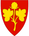 Coat of arms  Troms og Finnmark within Norway | |
 Nesseby within Troms og Finnmark | |
| Coordinates: 70°10′24″N 28°33′13″E / 70.17333°N 28.55361°ECoordinates: 70°10′24″N 28°33′13″E / 70.17333°N 28.55361°E | |
| Country | Norway |
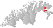
| County | Troms og Finnmark |
| District | Øst-Finnmark |
| Established | 1839 |
| Administrative centre | Varangerbotn |
| Government | |
| • Mayor (2011) | Knut Inge Store (Ap) |
| Area | |
| • Total | 1,436.94 km2 (554.81 sq mi) |
| • Land | 1,365.92 km2 (527.38 sq mi) |
| • Water | 71.02 km2 (27.42 sq mi) 4.9% |
| Area rank | 62 in Norway |
| Population (2020) | |
| • Total | 926 |
| • Rank | 340 in Norway |
| • Density | 0.7/km2 (2/sq mi) |
| • Change (10 years) | 4.8% |
| Demonym(s) | Nessebyværing[1] |
| Time zone | UTC+01:00 (CET) |
| • Summer (DST) | UTC+02:00 (CEST) |
| ISO 3166 code | NO-5442 |
| Official language form | Bokmål and Sami[2] |
| Website | nesseby |

Unjárga (Northern Sami) or Nesseby (Norwegian)[3] (also unofficially Uuniemi in Kven) is a municipality in Troms og Finnmark county, Norway. The administrative centre of the municipality is the village of Varangerbotn. Other villages in Nesseby include , Karlebotn, Nesseby, and Nyelv. The European route E06 and European route E75 highways intersect at Varangerbotn in Nesseby.
The 1,437-square-kilometre (555 sq mi) municipality is the 62nd largest by area out of the 356 municipalities in Norway. Nesseby is the 340th most populous municipality in Norway with a population of 926. The municipality's population density is 0.7 inhabitants per square kilometre (1.8/sq mi) and its population has increased by 4.8% over the previous 10-year period.[4][5]
In 2013, 26% of jobs of were within the health sector and social sector; 8% were within education; there were 373 jobs in the municipality.[6] The hydroelectric power station, produces [around] 20.1 gigawatthours (as of 2021).[7]
General information[]
The municipality of Nesseby was originally established in 1839 when the western part of the Vadsø landdistrikt was separated to form Nesseby. Initially, there were 598 residents. This was short-lived, however, since the two were merged back together in 1858. On 1 January 1864, the municipality of Nesseby was again created from the western district of Vadsø landdistrikt. The initial population (this time) was 886. The western part of Nesseby (population: 450) was separated on 1 January 1903 to form the new municipality of Polmak.[8]
On 1 January 2020, the municipality became part of the newly formed Troms og Finnmark county. Previously, it had been part of the old Finnmark county.[9]
Name[]
The official name of the municipality was Nesseby before 1989 when it was changed to Unjárga-Nesseby.[10] It was the second municipality in Norway to get a Sami name. In 2005, the name was again changed, such that either Unjárga or Nesseby can be used.[11]
The municipality (originally the parish) is named after the old Nesseby farm, since Nesseby Church was built there (in 1858). The first element is nes which means "headland" and the last element is by which means "town".[12]
The meaning of the first element (u-) in the Sami name is unknown and the last element is njárga which means "headland".[12]
Coat of arms[]
The coat of arms is from modern times; they were granted on 27 June 1986. The arms show a cloudberry plant (Rubus chamaemorus), since these plants are commonly found in the municipality and the region. The berries were historically exported to other parts of Norway by the barrel.[13]
Churches[]
The Church of Norway has one parish (sokn) within the municipality of Nesseby. It is part of the Indre Finnmark prosti (deanery) in the Diocese of Nord-Hålogaland.
| Parish (sokn) | Church name | Location | Year built |
|---|---|---|---|
| Nesseby | Nesseby Church | Nesseby | 1858 |
History[]


Wild reindeer used to cross the isthmus in prehistoric times until the year 1900, causing extensive human activity throughout the millennia. Therefore, the area is full of archeological finds from different periods.
Sami culture[]
Most inhabitants are of Sami origin,[citation needed] and today Sami is being taught as the first language in schools. The municipality has its own Sami costume.
The Norwegian Sami Parliament's department of culture and environment is located in Unjárga-Nesseby. The Várjjat Sámi Museum is located in the municipality. The museum is about the sea-sami culture. Unjárga-Nesseby is also the birthplace of Isak Saba the first Sami to be elected into the Norwegian Parliament.
The popular teen-age pop-band The Blacksheeps come from Nesseby.
Government[]
All municipalities in Norway, including Nesseby, are responsible for primary education (through 10th grade), outpatient health services, senior citizen services, unemployment and other social services, zoning, economic development, and municipal roads. The municipality is governed by a municipal council of elected representatives, which in turn elect a mayor.[14] The municipality falls under the Indre Finnmark District Court and the Hålogaland Court of Appeal.
Municipal council[]
The municipal council (Kommunestyre) of Nesseby is made up of 15 representatives that are elected to four year terms. The party breakdown of the council is as follows:
| Party Name (in Norwegian) | Number of representatives | |
|---|---|---|
| Labour Party (Arbeiderpartiet) | 7 | |
| Conservative Party (Høyre) | 1 | |
| Sámi People's Party (Samefolkets Parti) | 2 | |
| Centre Party (Senterpartiet) | 3 | |
| Socialist Left Party (Sosialistisk Venstreparti) | 1 | |
| Cross-Party List (Tverrpolitisk liste) | 1 | |
| Total number of members: | 15 | |
Geography[]
The municipality is situated on the isthmus between the Varangerfjord and the Tana River at the entrance to the Varanger Peninsula. All the people live in small settlements along the fjord. Varangerhalvøya National Park is partially located in the park. The river Jakobselva partially forms the municipal border between Nesseby and Vadsø to the northeast.
Birdlife[]
The municipality of Unjárga-Nesseby is known for its interesting birding localities and is mentioned in several birding guide books. Other than the Varangerford, the main habitat is tundra with areas of bog and marsh. One species that can usually be seen on small ponds during the summer months is the red-necked phalarope.
Climate[]
| hideClimate data for Varangerbotn | |||||||||||||
|---|---|---|---|---|---|---|---|---|---|---|---|---|---|
| Month | Jan | Feb | Mar | Apr | May | Jun | Jul | Aug | Sep | Oct | Nov | Dec | Year |
| Daily mean °C (°F) | −11.9 (10.6) |
−11.0 (12.2) |
−7.4 (18.7) |
−2.3 (27.9) |
3.1 (37.6) |
8.6 (47.5) |
12.2 (54.0) |
10.5 (50.9) |
6.1 (43.0) |
0.3 (32.5) |
−5.7 (21.7) |
−9.9 (14.2) |
−0.6 (30.9) |
| Average precipitation mm (inches) | 27 (1.1) |
22 (0.9) |
21 (0.8) |
21 (0.8) |
24 (0.9) |
37 (1.5) |
55 (2.2) |
53 (2.1) |
44 (1.7) |
41 (1.6) |
34 (1.3) |
31 (1.2) |
410 (16.1) |
| Source: Norwegian Meteorological Institute[33] | |||||||||||||
Notable people[]

- Søren Kristian Sommerfelt (1851–1934), Lutheran priest
- Anathon Aall (1867–1943), academic, philosopher and psychologist
- Isak Saba (1874–1921), the first Sami to be elected to the Stortinget
- Finn Lützow-Holm (1890–1950), military officer, aviation pioneer and polar explorer
- Anton Johnson Brandt (1893–1951), veterinarian and academic
- Signe Iversen (born 1956), Sami-language consultant and author of children's literature
- Raimo Valle (born 1965), civil servant and politician for the Labour Party
- Silje Karine Muotka (born 1975), member of the Sami Parliament of Norway
- Kirsti Bergstø (born 1981), politician for the Socialist Left Party
- Agnete Johnsen (born 1994), musician and lead singer of The BlackSheeps
References[]
- ^ "Navn på steder og personer: Innbyggjarnamn" (in Norwegian). Språkrådet.
- ^ "Forskrift om målvedtak i kommunar og fylkeskommunar" (in Norwegian). Lovdata.no.
- ^ "Stadnamn og rettskriving" (in Norwegian). Kartverket. Retrieved 2018-07-13.
- ^ Statistisk sentralbyrå (2020). "Table: 06913: Population 1 January and population changes during the calendar year (M)" (in Norwegian).
- ^ Statistisk sentralbyrå (2020). "09280: Area of land and fresh water (km²) (M)" (in Norwegian).
- ^ https://www.statsforvalteren.no/siteassets/utgatt/fm-finnmark/dokument-fmfi/kommunal-styring/kommunereformen/nesseby.pdf. page 10. "Undervisning [...] 33 [8.8] [...] Helse og sosial [...] 100 [26.8] [...] 373"
- ^ "Nesseby". 28 June 2021.
- ^ Jukvam, Dag (1999). "Historisk oversikt over endringer i kommune- og fylkesinndelingen" (PDF) (in Norwegian). Statistisk sentralbyrå.
- ^ Mæhlum, Lars, ed. (2019-12-24). "Troms og Finnmark". Store norske leksikon (in Norwegian). Kunnskapsforlaget. Retrieved 2019-12-26.
- ^ "Ot.prp. nr. 111 (2001-2002)" (in Norwegian). Regjeringen.no. 5 July 2002.
- ^ "Endring av skrivemåten for tospråklige kommuner. Endring av skrivemåten for tospråklige kommunenavn, Unjárga-Nesseby" (in Norwegian).
- ^ Jump up to: a b Rygh, Oluf (1924). Norske gaardnavne: Finmarkens amt (in Norwegian) (18 ed.). Kristiania, Norge: W. C. Fabritius & sønners bogtrikkeri. p. 246.
- ^ "Civic heraldry of Norway - Norske Kommunevåpen". Heraldry of the World. Retrieved 2017-08-20.
- ^ Hansen, Tore, ed. (2016-05-12). "kommunestyre". Store norske leksikon (in Norwegian). Kunnskapsforlaget. Retrieved 2018-05-30.
- ^ "Tall for Norge: Kommunestyrevalg 2019 - Troms og Finnmark". Valg Direktoratet. Retrieved 2019-10-23.
- ^ Jump up to: a b c d "Table: 04813: Members of the local councils, by party/electoral list at the Municipal Council election (M)" (in Norwegian). Statistics Norway.
- ^ "Tall for Norge: Kommunestyrevalg 2011 - Finnmark". Valg Direktoratet. Retrieved 2019-10-23.
- ^ "Kommunestyrevalget 1995" (PDF) (in Norwegian). Oslo-Kongsvinger: Statistisk sentralbyrå. 1996. Retrieved 2020-02-20.
- ^ "Kommunestyrevalget 1991" (PDF) (in Norwegian). Oslo-Kongsvinger: Statistisk sentralbyrå. 1993. Retrieved 2020-02-20.
- ^ "Kommunestyrevalget 1987" (PDF) (in Norwegian). Oslo-Kongsvinger: Statistisk sentralbyrå. 1988. Retrieved 2020-02-20.
- ^ "Kommunestyrevalget 1983" (PDF) (in Norwegian). Oslo-Kongsvinger: Statistisk sentralbyrå. 1984. Retrieved 2020-02-20.
- ^ "Kommunestyrevalget 1979" (PDF) (in Norwegian). Oslo: Statistisk sentralbyrå. 1979. Retrieved 2020-02-20.
- ^ "Kommunevalgene 1975" (PDF) (in Norwegian). Oslo: Statistisk sentralbyrå. 1977. Retrieved 2020-03-16.
- ^ "Kommunevalgene 1972" (PDF) (in Norwegian). Oslo: Statistisk sentralbyrå. 1973. Retrieved 2020-03-16.
- ^ "Kommunevalgene 1967" (PDF) (in Norwegian). Oslo: Statistisk sentralbyrå. 1967. Retrieved 2020-03-16.
- ^ "Kommunevalgene 1963" (PDF) (in Norwegian). Oslo: Statistisk sentralbyrå. 1964. Retrieved 2020-03-16.
- ^ "Kommunevalgene og Ordførervalgene 1959" (PDF) (in Norwegian). Oslo: Statistisk sentralbyrå. 1960. Retrieved 2020-03-16.
- ^ "Kommunevalgene og Ordførervalgene 1955" (PDF) (in Norwegian). Oslo: Statistisk sentralbyrå. 1957. Retrieved 2020-03-16.
- ^ "Kommunevalgene og Ordførervalgene 1951" (PDF) (in Norwegian). Oslo: Statistisk sentralbyrå. 1952. Retrieved 2020-03-16.
- ^ "Kommunevalgene og Ordførervalgene 1947" (PDF) (in Norwegian). Oslo: Statistisk sentralbyrå. 1948. Retrieved 2020-03-16.
- ^ "Kommunevalgene og Ordførervalgene 1945" (PDF) (in Norwegian). Oslo: Statistisk sentralbyrå. 1947. Retrieved 2020-03-16.
- ^ "Kommunevalgene og Ordførervalgene 1937" (PDF) (in Norwegian). Oslo: Statistisk sentralbyrå. 1938. Retrieved 2020-03-16.
- ^ "eKlima Web Portal". Norwegian Meteorological Institute. Archived from the original on 2004-06-14.
External links[]
| Wikimedia Commons has media related to Nesseby. |
- http://www.nesseby.kommune.no/ Official homepage (in Norwegian)
- Municipal fact sheet from Statistics Norway (in Norwegian)
- http://www.varjjat.org/ Várjjat Sámi Museum (in Northern Sami)
- http://www.isaksaba.no/ Isak Saba center (in Northern Sami)


| show Authority control |
|---|
- Nesseby
- Municipalities of Troms og Finnmark
- Sámi-language municipalities
- Populated places of Arctic Norway
- 1839 establishments in Norway
- 1858 disestablishments in Norway
- 1864 establishments in Norway