Hopson, Mississippi
Hopson, Mississippi | |
|---|---|
 Hopson Plantation | |
 Hopson | |
| Coordinates: 34°09′31″N 90°32′47″W / 34.15861°N 90.54639°WCoordinates: 34°09′31″N 90°32′47″W / 34.15861°N 90.54639°W | |
| Country | United States |
| State | Mississippi |
| County | Coahoma |
| Elevation | 167 ft (53 m) |
| Time zone | UTC-6 (Central (CST)) |
| • Summer (DST) | UTC-5 (CDT) |
| ZIP code | 38614 |
| Area code(s) | 662 |
| GNIS feature ID | 671454[1] |


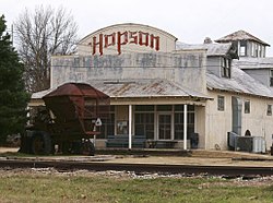
Hopson (also known as Hopson Plantation or Hopson Spur) is an unincorporated community located in Coahoma County, Mississippi, United States, south of Clarksdale and U.S. Route 61 along U.S. Route 49. Hopson is located on the former Yazoo and Mississippi Valley Railroad.[2] A post office operated under the name Hopson from 1857 to 1867.[3] In 1944 The Hopson Planting Company used International Harvester cotton pickers to harvest cotton, becoming the first farm to mechanically cultivate and produce an entire cotton crop.[4] The former Hopson Plantation Company Store is now operated as a restaurant and music venue.[5]
Notable person[]
- Pinetop Perkins, blues pianist, worked at Hopson Plantation as a tractor driver[6]
Gallery[]

Historical marker in the Hopson community

References[]
- ^ U.S. Geological Survey Geographic Names Information System: Hopson, Mississippi
- ^ Howe, Tony. "Hopson's Spur, Mississippi". Mississippi Rails. Retrieved 8 June 2020.
- ^ "Coahoma County". Jim Forte Postal History. Retrieved 8 June 2020.
- ^ Judith Coleman Flowers; Carnegie Public Library (14 March 2016). Clarksdale and Coahoma County. Arcadia Publishing. ISBN 978-1-4396-5503-0.
- ^ June Davis Davidson (3 June 2014). Country Stores of Mississippi. Arcadia Publishing Incorporated. p. 107. ISBN 978-1-62585-125-3.
- ^ "Hopson Planting Co". Mississippi Blues Trail. Retrieved 9 June 2020.
Municipalities and communities of Coahoma County, Mississippi, United States | ||
|---|---|---|
| City |  | |
| Towns | ||
| CDPs | ||
| Other communities | ||
| Ghost towns | ||
| Footnotes | ‡This populated place also has portions in an adjacent county or counties | |
| ||
This Coahoma County, Mississippi state location article is a stub. You can help Wikipedia by . |
- Unincorporated communities in Coahoma County, Mississippi
- Unincorporated communities in Mississippi
- Mississippi Delta region geography stubs