Horné Mladonice
This article does not cite any sources. (December 2009) |
Horné Mladonice | |
|---|---|
Municipality | |
 Horné Mladonice Location of Horné Mladonice in the Banská Bystrica Region | |
| Coordinates: 48°21′N 19°09′E / 48.350°N 19.150°ECoordinates: 48°21′N 19°09′E / 48.350°N 19.150°E | |
| Country | |
| Region | Banská Bystrica |
| District | Krupina |
| First mentioned | 1470 |
| Area | |
| • Total | 1,183 km2 (457 sq mi) |
| Elevation | 480 m (1,570 ft) |
| Postal code | 962 43 (pošta Senohrad) |
| Area code(s) | +421-45 |
| Car plate | KA |
| Website | www.hornemladonice.sk |


Horné Mladonice is a village and municipality in the Krupina District of the Banská Bystrica Region of Slovakia.
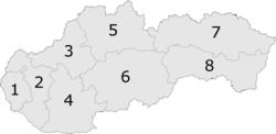
6: Banská Bystrica Region
Genealogical resources[]
The records for genealogical research are available at the state archive "Statny Archiv in Banska Bystrica, Slovakia"
- Roman Catholic church records (births/marriages/deaths): 1792-1890 (parish B)
- Lutheran church records (births/marriages/deaths): 1757-1873 (parish B)
See also[]
External links[]
This Banská Bystrica Region geography article is a stub. You can help Wikipedia by . |
Categories:
- Villages and municipalities in Krupina District
- Banská Bystrica Region geography stubs