Terany
This article does not cite any sources. (December 2009) |
Terany | |
|---|---|
Municipality | |
 | |
 Terany Location of Terany in the Banská Bystrica Region | |
| Coordinates: 48°11′N 18°54′E / 48.183°N 18.900°ECoordinates: 48°11′N 18°54′E / 48.183°N 18.900°E | |
| Country | |
| Region | Banská Bystrica |
| District | Krupina |
| First mentioned | 1298 |
| Area | |
| • Total | 10.83 km2 (4.18 sq mi) |
| Elevation | 144 m (472 ft) |
| Time zone | UTC+1 (CET) |
| • Summer (DST) | UTC+2 (CEST) |
| Postal code | 962 68 (pošta Hontianske Tesáre) |
| Area code(s) | +421-45 |
| Car plate | KA |
| Website | www.obecterany.sk |


Terany is a village and municipality in the Krupina District of the Banská Bystrica Region of Slovakia.
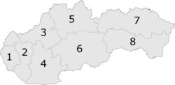
6: Banská Bystrica Region
External links[]
 Media related to Terany at Wikimedia Commons
- Official website

This Banská Bystrica Region geography article is a stub. You can help Wikipedia by . |
Categories:
- Villages and municipalities in Krupina District
- Banská Bystrica Region geography stubs