Horné Trhovište
Horné Trhovište | |
|---|---|
Municipality | |
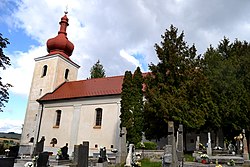 Church in Horné Trhovište | |
 Horné Trhovište Location of Dolné Trhovište in the Trnava Region | |
| Coordinates: 48°28′N 17°52′E / 48.467°N 17.867°ECoordinates: 48°28′N 17°52′E / 48.467°N 17.867°E | |
| Country | Slovakia |
| Region | Trnava |
| District | Hlohovec |
| First mentioned | 1332 |
| Area | |
| • Total | 7.544 km2 (2.913 sq mi) |
| Elevation | 222 m (728 ft) |
| Population | |
| • Total | 548 |
| • Density | 73/km2 (190/sq mi) |
| Postal code | 920 66 |
| Area code(s) | +421-33 |
| Car plate | HC |
| Website | www.obechornetrhoviste.sk |


Horné Trhovište is a village and municipality in Hlohovec District in the Trnava Region of western Slovakia.
History[]
In historical records the village was first mentioned in 1332.
Geography[]
The municipality lies at an altitude of 222 metres and covers an area of 7.544 km². It has a population of about 548 people.
Genealogical resources[]
The records for genealogical research are available at the state archive "Statny Archiv in Bratislava, Nitra, Slovakia"
- Roman Catholic church records (births/marriages/deaths): 1719-1899 (parish A)
See also[]
External links[]
- https://web.archive.org/web/20070513023228/http://www.statistics.sk/mosmis/eng/run.html
- Surnames of living people in Horne Trhoviste
Municipalities of Hlohovec District | ||
|---|---|---|
This Trnava Region geography article is a stub. You can help Wikipedia by . |
Categories:
- Villages and municipalities in Hlohovec District
- Trnava Region geography stubs