Koplotovce
Koplotovce | |
|---|---|
Municipality | |
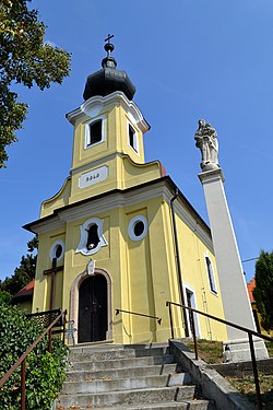 Church of Visitation of Virgin Mary | |
 Koplotovce Location of Koplotovce in the Trnava Region | |
| Coordinates: 48°28′N 17°49′E / 48.467°N 17.817°ECoordinates: 48°28′N 17°49′E / 48.467°N 17.817°E | |
| Country | |
| Region | Trnava |
| District | Hlohovec |
| First mentioned | 1113 |
| Area | |
| • Total | 5.799 km2 (2.239 sq mi) |
| Elevation | 165 m (541 ft) |
| Population | |
| • Total | 580 |
| • Density | 100/km2 (260/sq mi) |
| Postal code | 920 01 (pošta Hlohovec 1) |
| Area code(s) | +421-33 |
| Car plate | HC |
| Website | www.koplotovce.sk |


Koplotovce is a village and municipality in Hlohovec District in the Trnava Region of western Slovakia.
History[]
In historical records the village was first mentioned in 1113.
Geography[]
The municipality lies at an altitude of 165 metres and covers an area of 5.799 km². It has a population of about 580 people.
Genealogical resources[]
The records for genealogical research are available at the state archive "Statny Archiv in Bratislava, Nitra, Slovakia"
- Roman Catholic church records (births/marriages/deaths): 1660-1901 (parish B)
See also[]
External links[]
 Media related to Koplotovce at Wikimedia Commons
- Official website

- https://web.archive.org/web/20080111223415/http://www.statistics.sk/mosmis/eng/run.html
- Surnames of living people in Koplotovce
Municipalities of Hlohovec District | ||
|---|---|---|
This Trnava Region geography article is a stub. You can help Wikipedia by . |
Categories:
- Villages and municipalities in Hlohovec District
- Trnava Region geography stubs