Hornchurch and Upminster (UK Parliament constituency)
This article uses bare URLs, which may be threatened by link rot. (May 2021) |
| Hornchurch and Upminster | |
|---|---|
| Borough constituency for the House of Commons | |
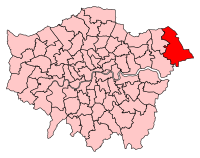 Boundary of Hornchurch and Upminster in Greater London | |
| County | Greater London |
| Electorate | 79,568 (December 2010)[1] |
| Current constituency | |
| Created | 2010 |
| Member of Parliament | Julia Lopez (Conservative) |
| Number of members | One |
| Created from | Hornchurch, Upminster, Romford |
Hornchurch and Upminster is a constituency[n 1] represented in the House of Commons of the UK Parliament since 2017 by Julia Lopez of the Conservative Party.[n 2]
Constituency profile and history[]
The easternmost seat in Greater London, this seat was created by merging two of the three old constituencies comprising the London borough of Havering, specifically Hornchurch and Upminster. These two seats were lost by the Conservatives in Labour's landslide 1997 victory, but Upminster was one of the few Conservative gains in 2001 and Hornchurch was lost by Labour in 2005; this area is now very safe territory for the Conservatives since it gained their strongest areas from Hornchurch in the boundary changes. The 2015 result made the seat the 146th safest of the Conservative Party's 331 seats by percentage of majority.[2] Also in the 2015 election, UKIP beat two of the 'big three' parties, Labour and the Liberal Democrats, and came second with 25% of the vote - one of their best results in the country that year.
The constituency includes affluent areas such as Hornchurch town centre, Cranham[citation needed] and Upminster. Limited pockets of deprivation exist in the north of the constituency and most output areas have high levels of retired constituents by Greater London standards, and the borough as a whole is similar to the London Borough of Bromley in that it has high levels of home ownership, on statistics compiled in the 2011 UK Census. The seat, like the London borough, is the only one in London that extends beyond the M25 motorway.[3]
Boundaries[]

The seat was the proposal of the Boundary Commission's Fifth Periodic Review of Westminster constituencies in 2008-9 and was after consultation accepted by Parliament. Hornchurch and Upminster is essentially an expansion of the old Upminster seat to include a chunk of the old Hornchurch seat – specifically Hornchurch itself. Most of the western wards of Hornchurch went to the new Dagenham and Rainham seat.
The constituency of Hornchurch and Upminster is made up of eight electoral wards from the London Borough of Havering:
- Cranham, Emerson Park, Gooshays, Hacton, Harold Wood, Heaton, St Andrew's, Upminster.
Members of Parliament[]
| Election | Member[4] | Party | |
|---|---|---|---|
| 2010 | Dame Angela Watkinson | Conservative | |
| 2017 | Julia Lopez | Conservative | |
Election results[]
Elections in the 2010s[]

| Party | Candidate | Votes | % | ±% | |
|---|---|---|---|---|---|
| Conservative | Julia Lopez | 35,495 | 65.8 | +5.6 | |
| Labour | Tele Lawal | 12,187 | 22.6 | -6.0 | |
| Liberal Democrats | Thomas Clarke | 3,862 | 7.2 | +4.8 | |
| Green | Peter Caton | 1,920 | 3.6 | +1.7 | |
| BNP | David Furness | 510 | 0.9 | +0.2 | |
| Majority | 23,308 | 43.2 | +11.6 | ||
| Turnout | 53,974 | 66.8 | -2.6 | ||
| Registered electors | 80,765 | ||||
| Conservative hold | Swing | +5.8 | |||
| Party | Candidate | Votes | % | ±% | |
|---|---|---|---|---|---|
| Conservative | Julia Dockerill | 33,750 | 60.2 | +11.2 | |
| Labour | Rocky Gill | 16,027 | 28.6 | +8.5 | |
| UKIP | Lawrence Webb | 3,502 | 6.2 | -19.1 | |
| Liberal Democrats | Jonathan Mitchell | 1,371 | 2.4 | -0.3 | |
| Green | Peter Caton | 1,077 | 1.9 | -0.7 | |
| BNP | David Furness | 380 | 0.7 | +0.4 | |
| Majority | 17,723 | 31.6 | +7.9 | ||
| Turnout | 56,107 | 69.4 | -0.2 | ||
| Registered electors | 80,802 | ||||
| Conservative hold | Swing | +1.36 | |||
| Party | Candidate | Votes | % | ±% | |
|---|---|---|---|---|---|
| Conservative | Angela Watkinson | 27,051 | 49.0 | -2.4 | |
| UKIP | Lawrence Webb | 13,977 | 25.3 | +20.0 | |
| Labour | Paul McGeary | 11,103 | 20.1 | -0.7 | |
| Liberal Democrats | Jonathan Mitchell | 1,501 | 2.7 | -11.2 | |
| Green | Melanie Collins | 1,411 | 2.6 | +1.6 | |
| BNP | Paul Borg | 193 | 0.3 | -6.1 | |
| Majority | 13,074 | 23.7 | -6.9 | ||
| Turnout | 55,236 | 69.6 | +1.6 | ||
| Registered electors | 79,331 | ||||
| Conservative hold | Swing | -8.7 | |||
| Party | Candidate | Votes | % | ±% | |
|---|---|---|---|---|---|
| Conservative | Angela Watkinson* | 27,469 | 51.4 | ||
| Labour | Kath McGuirk | 11,098 | 20.8 | ||
| Liberal Democrats | Karen Chilvers | 7,426 | 13.9 | ||
| BNP | William Whelpley | 3,421 | 6.4 | ||
| UKIP | Lawrence Webb | 2,848 | 5.3 | ||
| Green | Melanie Collins | 542 | 1.0 | ||
| Independent | David Durant | 305 | 0.6 | ||
| Christian | Johnson Olukotun | 281 | 0.5 | ||
| Majority | 16,371 | 30.6 | |||
| Turnout | 53,390 | 68.0 | |||
| Registered electors | 78,547 | ||||
| Conservative win (new seat) | |||||
- * Served as MP for Upminster in the 2005–2010 Parliament
- The seat was contested for the first time in 2010, so percentage changes are based on notional results of the 2005 election.
Notes and references[]
- Notes
- ^ A borough constituency (for the purposes of election expenses and type of returning officer)
- ^ As with all constituencies, the constituency elects one Member of Parliament (MP) by the first past the post system of election at least every five years.
- References
- ^ "Electorate Figures – Boundary Commission for England". 2011 Electorate Figures. Boundary Commission for England. 4 March 2011. Archived from the original on 6 November 2010. Retrieved 13 March 2011.
- ^ List of Conservative MPs elected in 2015 by % majority UK Political.info. Retrieved 2017-01-29
- ^ "2011 census interactive maps". Archived from the original on January 29, 2016.
- ^ Leigh Rayment's Historical List of MPs – Constituencies beginning with "H" (part 4)
- ^ https://www.havering.gov.uk/download/downloads/id/3466/hornchurch_and_upminster_notice_of_poll_statement_of_persons_nominated_and_situations_of_polling_stations.pdf
- ^ "Hornchurch & Upminster parliamentary constituency". BBC News.
- ^ http://researchbriefings.files.parliament.uk/documents/CBP-7979/CBP-7979.pdf
- ^ "Hornchurch and Upminster - UK Parliament Constituency - Election Polling". www.electionpolling.co.uk.
- ^ "Election Data 2015". Electoral Calculus. Archived from the original on 17 October 2015. Retrieved 17 October 2015.
- ^ Havering, The London Borough Of. "Elections and voting - The London Borough Of Havering". www.havering.gov.uk.
- ^ "Election Data 2010". Electoral Calculus. Archived from the original on 26 July 2013. Retrieved 17 October 2015.
External links[]
- Politics Resources (Election results from 1922 onwards)
- Electoral Calculus (Election results from 1955 onwards)
- Hornchurch and Upminster, UKPollingReport

| Authority control |
|---|

- Politics of the London Borough of Havering
- Parliamentary constituencies in London
- Constituencies of the Parliament of the United Kingdom established in 2010
- Hornchurch