Howardsville, Colorado
Howardsville | |
|---|---|
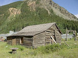 An old cabin at Howardsville | |
 Howardsville Location within the state of Colorado | |
| Coordinates: 37°50′8″N 107°35′39″W / 37.83556°N 107.59417°WCoordinates: 37°50′8″N 107°35′39″W / 37.83556°N 107.59417°W | |
| Country | United States |
| State | Colorado |
| County | San Juan |
| Elevation | 9,747 ft (2,971 m) |
| Time zone | UTC-7 (Mountain (MST)) |
| • Summer (DST) | UTC-6 (MDT) |
| GNIS feature ID | 187646[1] |

Howardsville is an unincorporated community in San Juan County, Colorado, United States, along the Animas River at the mouth of Cunningham Creek. Its elevation is 9,747 feet (2,971 m).
Established and laid out by the Bullion City Company as Bullion City in 1874, it was renamed later in the year, either for Lieutenant Howard, a once-prominent local figure, or for George Howard, who once had a cabin in the area. It was the first county seat of San Juan County, holding that title until 1875.[1] The Silverton Northern Railroad laid tracks to reach Howardsville in 1896, with an extension getting built from Howardsville into Cunningham Gulch to reach the Old Hundred Mine, along with the Green Mountain Mine, in 1905. The town would be sustained for the remainder of its life by the Pride Of The West Mill and the Little Nation Tram House & Mill, among other mines & mills. The town effectively died in 1939 when its post office shut down, and the Silverton Northern Railroad tracks would get torn up in 1942. [2][3]
References[]
External links[]
Municipalities and communities of San Juan County, Colorado, United States | ||
|---|---|---|
| Town |  | |
| Unincorporated communities | ||
| Ghost towns | ||
| ||
This Colorado state location article is a stub. You can help Wikipedia by . |
- Unincorporated communities in San Juan County, Colorado
- Unincorporated communities in Colorado
- Colorado geography stubs