Hoyt, Kansas
Hoyt, Kansas | |
|---|---|
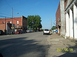 Downtown Hoyt (2007) | |
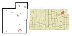 Location within Jackson County and Kansas | |
 | |
| Coordinates: 39°14′55″N 95°42′19″W / 39.24861°N 95.70528°WCoordinates: 39°14′55″N 95°42′19″W / 39.24861°N 95.70528°W | |
| Country | United States |
| State | Kansas |
| County | Jackson |
| Founded | 1886 |
| Incorporated | 1909 |
| Named for | George Hoyt |
| Area | |
| • Total | 0.47 sq mi (1.22 km2) |
| • Land | 0.47 sq mi (1.22 km2) |
| • Water | 0.00 sq mi (0.00 km2) |
| Elevation | 1,171 ft (357 m) |
| Population | |
| • Total | 669 |
| • Estimate (2019)[3] | 630 |
| • Density | 1,343.28/sq mi (518.35/km2) |
| Time zone | UTC-6 (CST) |
| • Summer (DST) | UTC-5 (CDT) |
| ZIP code | 66440 |
| Area code | 785 |
| FIPS code | 20-33375 [4] |
| GNIS ID | 478318 [5] |

Hoyt is a city in Jackson County, Kansas, United States. As of the 2010 census, the city population was 669.[6]
History[]
Hoyt was founded in 1886.[7] It was named for George Henry Hoyt, an abolitionist and attorney for John Brown.[8]
Geography[]
Hoyt is located at 39°14′55″N 95°42′19″W / 39.24861°N 95.70528°W (39.248709, -95.705375).[9] According to the United States Census Bureau, the city has a total area of 0.50 square miles (1.29 km2), all of it land.[10]
Climate[]
The climate in this area is characterized by hot, humid summers and generally mild to cool winters. According to the Köppen Climate Classification system, Hoyt has a humid subtropical climate, abbreviated "Cfa" on climate maps.[11]
Demographics[]
| Historical population | |||
|---|---|---|---|
| Census | Pop. | %± | |
| 1920 | 282 | — | |
| 1930 | 228 | −19.1% | |
| 1940 | 238 | 4.4% | |
| 1950 | 246 | 3.4% | |
| 1960 | 283 | 15.0% | |
| 1970 | 420 | 48.4% | |
| 1980 | 536 | 27.6% | |
| 1990 | 489 | −8.8% | |
| 2000 | 571 | 16.8% | |
| 2010 | 669 | 17.2% | |
| 2019 (est.) | 630 | [3] | −5.8% |
| U.S. Decennial Census | |||
Hoyt is part of the Topeka, Kansas Metropolitan Statistical Area.
2010 census[]
As of the census[2] of 2010, there were 669 people, 253 households, and 184 families residing in the city. The population density was 1,338.0 inhabitants per square mile (516.6/km2). There were 269 housing units at an average density of 538.0 per square mile (207.7/km2). The racial makeup of the city was 85.5% White, 0.1% African American, 9.6% Native American, 1.2% Asian, 0.9% from other races, and 2.7% from two or more races. Hispanic or Latino of any race were 5.1% of the population.
There were 253 households, of which 41.9% had children under the age of 18 living with them, 51.0% were married couples living together, 15.8% had a female householder with no husband present, 5.9% had a male householder with no wife present, and 27.3% were non-families. 23.7% of all households were made up of individuals, and 9.1% had someone living alone who was 65 years of age or older. The average household size was 2.64 and the average family size was 3.10.
The median age in the city was 34 years. 30.8% of residents were under the age of 18; 7.9% were between the ages of 18 and 24; 29.6% were from 25 to 44; 21.4% were from 45 to 64; and 10.3% were 65 years of age or older. The gender makeup of the city was 49.2% male and 50.8% female.
2000 census[]
As of the census[4] of 2000, there were 571 people, 206 households, and 156 families residing in the city. The population density was 1,336.5 people per square mile (512.7/km2). There were 219 housing units at an average density of 512.6 per square mile (196.6/km2). The racial makeup of the city was 94.05% White, 2.98% Native American, 0.53% Asian, 0.70% from other races, and 1.75% from two or more races. Hispanic or Latino of any race were 2.63% of the population.
There were 206 households, out of which 42.2% had children under the age of 18 living with them, 60.7% were married couples living together, 9.2% had a female householder with no husband present, and 23.8% were non-families. 20.4% of all households were made up of individuals, and 8.7% had someone living alone who was 65 years of age or older. The average household size was 2.77 and the average family size was 3.18.
In the city, the population was spread out, with 32.2% under the age of 18, 7.2% from 18 to 24, 31.3% from 25 to 44, 17.7% from 45 to 64, and 11.6% who were 65 years of age or older. The median age was 31 years. For every 100 females, there were 99.7 males. For every 100 females age 18 and over, there were 99.5 males.
The median income for a household in the city was $46,806, and the median income for a family was $46,806. Males had a median income of $35,188 versus $22,750 for females. The per capita income for the city was $15,116. About 4.2% of families and 7.4% of the population were below the poverty line, including 12.3% of those under age 18 and none of those age 65 or over.
Education[]
The community is served by Royal Valley USD 337 public school district, and Royal Valley High School.
References[]
- ^ "2019 U.S. Gazetteer Files". United States Census Bureau. Retrieved July 24, 2020.
- ^ a b "U.S. Census website". United States Census Bureau. Retrieved 2012-07-06.
- ^ a b "Population and Housing Unit Estimates". United States Census Bureau. May 24, 2020. Retrieved May 27, 2020.
- ^ a b "U.S. Census website". United States Census Bureau. Retrieved 2008-01-31.
- ^ "US Board on Geographic Names". United States Geological Survey. 2007-10-25. Retrieved 2008-01-31.
- ^ "2010 City Population and Housing Occupancy Status". U.S. Census Bureau. Retrieved March 17, 2012.[dead link]
- ^ Blackmar, Frank Wilson (1912). Kansas: A Cyclopedia of State History, Embracing Events, Institutions, Industries, Counties, Cities, Towns, Prominent Persons, Etc. Standard Publishing Company. pp. 878.
- ^ "Profile for Hoyt, Kansas". ePodunk. Archived from the original on 14 July 2014. Retrieved 11 June 2014.
- ^ "US Gazetteer files: 2010, 2000, and 1990". United States Census Bureau. 2011-02-12. Retrieved 2011-04-23.
- ^ "US Gazetteer files 2010". United States Census Bureau. Archived from the original on 2012-01-25. Retrieved 2012-07-06.
- ^ Climate Summary for Hoyt, Kansas
Further reading[]
- Living in the Depot: The Two-Story Railroad Station; H. Roger Grant; University of Iowa Press; 130 pages; 1993; ISBN 978-0877455882. Contains historic images of Kansas stations at Alta Vista, Bucklin, Comiskey, Haddam, Hoyt, and Wakarusa.
External links[]
| Wikimedia Commons has media related to Hoyt, Kansas. |
- Hoyt - Directory of Public Officials
- USD 337, local school district
- Hoyt City Map, KDOT
Municipalities and communities of Jackson County, Kansas, United States | ||
|---|---|---|
| Cities |  | |
| Unincorporated communities | ||
| Indian reservations | ||
| Townships | ||
| Footnotes | ‡This community also has portions in an adjacent county or counties. | |
| ||
- Cities in Kansas
- Cities in Jackson County, Kansas
- Topeka metropolitan area, Kansas