Hunterdon County, New Jersey
Hunterdon County | |
|---|---|
 The Delaware and Raritan Canal in Lambertville | |
 Flag  Seal | |
 Location within the U.S. state of New Jersey | |
 New Jersey's location within the U.S. | |
| Coordinates: 40°34′N 74°55′W / 40.57°N 74.92°WCoordinates: 40°34′N 74°55′W / 40.57°N 74.92°W | |
| Country | |
| State | |
| Founded | 1714 |
| Named for | Robert Hunter |
| Seat | Flemington[1] |
| Largest city | Raritan Township (population) Readington Township (area) |
| Government | |
| • Freeholder Director | Susan Soloway (R, term ends December 31, 2021) |
| Area | |
| • Total | 437.44 sq mi (1,133.0 km2) |
| • Land | 427.82 sq mi (1,108.0 km2) |
| • Water | 9.62 sq mi (24.9 km2) 2.20% |
| Population (2020) | |
| • Total | 128,947 |
| • Density | 290/sq mi (110/km2) |
| Congressional district | 7th |
| Website | www |


Hunterdon County is a county located in the western section of the U.S. state of New Jersey. As of the 2019 Census estimate, the county's population was 124,371, making it the state's 18th-most populous county,[2][3][4] representing a 3.1% decrease from the 128,349 enumerated in the 2010 United States Census,[5] in turn increasing by 6,360 (+5.2%) from the 121,989 counted in the 2000 Census.[6] Its county seat is Flemington.[1]
In 2015, the county had a per capita personal income of $80,759, the third-highest in New Jersey and ranked 33rd of 3,113 counties in the United States.[7][8] The Bureau of Economic Analysis ranked the county as having the 19th-highest per capita income of all 3,113 counties in the United States (and the highest in New Jersey) as of 2009.[9] Hunterdon County is noted for having the second-lowest level of child poverty of any county in the United States.[10]
Geographically, much of the county lies in the Delaware Valley as a geographic concept, that is, the drainage basin of the Delaware River. Local businesses and the Delaware Valley Regional High School carry the name. However, "Delaware Valley" is also used to refer to the Philadelphia-Reading-Camden Combined Statistical Area (CSA), and Hunterdon County does not belong to the Philadelphia CSA, but rather to the New York-Northern New Jersey-Long Island Metropolitan Statistical Area (MSA), part of the larger New York-Newark Combined Statistical Area (CSA).[11] It is located within the state's Skylands Region.
Hunterdon County was established on March 11, 1714, separating from Burlington County, at which time it included all of present-day Morris, Sussex and Warren counties.[12] The rolling hills and rich soils which produce bountiful agricultural crops drew Native American tribes and then Europeans to the area.
Geology[]
This section does not cite any sources. (June 2017) |
Around 500 million years ago, a chain of volcanic islands shaped like an arch collided with proto North America and rode over the top of the North American plate. The rock from the islands created the highlands of Hunterdon County as there was a shallow sea where Hunterdon County is now located. Then around four hundred million B.C., a small continent that was long and thin, collided with proto North America. This collision created compression, which caused heat. The Paleozoic sediment of shale and sandstone folded and faulted. The heat allowed the igneous rock to bend, thus Hunterdon County was born.
The African plate which later collided with North America created more folding and faulting, especially in the southern Appalachians. Then the African and North America plates tore and drifted away from each other.
The Wisconsin glacier that entered into New Jersey around 21,000 BCE and then melted around 13,000 BCE did not reach Hunterdon County. However, there are glacial outwash deposits from streams and rivers that flowed from the glacier southward depositing rock and sediment.
Hunterdon County has two geophysical provinces. The first is the Highlands which is the western section of the county. The other is the Piedmont which is the eastern and southern section of the county. The Highlands account for one-third of the area and Piedmont accounts for two-thirds of the county.
The Highlands are part of the Reading Prong. Limestone and shale over igneous rock comprise the Highlands.
Piedmont includes the Hunterdon Plateau and the Raritan Valley Lowlands which are 150 to 300 feet (46 to 91 m) above sea level. Piedmont is made up of shale and sandstone.


History[]
Paleo Indians and Native Americans[]
Paleo Indians moved into Hunterdon County between 12,000 BCE and 11,000 BCE. The area was warming due to climate change. The Wisconsin Glacier in Warren and Sussex County was retreating northward. The area was that of Taiga/Boreal forests. Paleo Indians traveled in small groups in search of game and edible plants. They used spears made of bone, jasper or black chert. Their camp sites are difficult to find as they are many feet below the present surface.[citation needed]
Native Americans moved into the area but the time they arrived is unknown. Most have come from the Mississippi River area. Many tribes of the Delaware Nation lived in Hunterdon County especially along the Delaware River and in the Flemington area. These tribes were agricultural in nature, growing corn, beans and squash. Those that lived along the South Branch of the Raritan River fished and farmed. There was a Native American trail that went along the South Branch of the Raritan River (Philhower 1924).
European settlement[]
Land purchases from Native Americans occurred from 1688 to 1758. Large land purchases from Native Americans occurred in 1703, 1709 and 1710. Over 150,000 acres (610 km2) were bought with metal knives and pots, clothing, blankets, barrels of rum or hard cider, guns, powder and shot. This allowed for European settlers to enter into Hunterdon County in the early 18th century. After 1760, nearly all Native Americans left New Jersey and relocated to eastern Canada or the Mississippi River area.[citation needed]
The first European settlers were Col. John Reading who settled in Reading Township in 1704 and John Holcombe who settled in Lambertville in 1705.[13]
County origin[]
Hunterdon County was separated from Burlington County on March 11, 1714. At that time Hunterdon County was large, going from Assunpink Creek near Trenton to the New York State line which at that time was about 10 miles (16 km) north of Port Jervis, New York.[12] Hunterdon County was named for Robert Hunter, a colonial governor of New Jersey.[14] Language changes over time and location, so by stemming of [s], and a [t] → [d] lenition of the name of his family seat of "Hunterston" in Ayrshire, Scotland, the name "Hunterdon" was derived.[13][15]
On March 15, 1739, Morris County (which at the time included what would later become Sussex County and Warren County) was separated from Hunterdon County.[12] The boundary between Hunterdon and Somerset counties is evidence of the old Keith Line which separated the provinces of West Jersey and East Jersey.
Hunterdon County was reduced in area on February 22, 1838, with the formation of Mercer County from portions of Burlington County, Hunterdon County and Middlesex County. In February 1839, the remaining portion of Hopewell Township was annexed to Mercer County. On March 13, 1844 Hopewell Township returned to Hunterdon County while Tewksbury Township was annexed by Somerset County but in February 1845 both of these changes were repealed. Since then, the county boundaries have remained the same.[12]
Hunterdon County was being affected by industrialization in the state and nation, mining speculation in northwest New Jersey, and competitors constructing railroads. The Elizabethtown and Somerville Railroad leased a section to White House just south of Tewksbury Township in 1848.[citation needed]
Recent history[]
Transitioning from rural to suburban, Hunterdon County is an exurb on the western edge of New Jersey and home to commuters to New York City and Philadelphia. The county seat, Flemington, is noted as the site of the Lindbergh kidnapping trial which convicted Bruno Hauptmann of the murder of aviator Charles Lindbergh's son. With growing towns and shopping areas, as well as relaxing rural areas, Hunterdon County is a far stretch from the urban areas stereotypically associated with New Jersey. Due to the presence of natural habitats with many homes in wooded settings, Hunterdon County was recently found to have the third highest case rate of Lyme disease out of all counties in the United States.[16]
On December 24, 2020, The Hunterdon County Library System announced that the library system will be joining the MAIN Library System which covers libraries in Morris County and parts of Somerset and Warren counties, this merger was completed on January 11, 2021.[17]
Geography[]
According to the 2010 Census, the county had a total area of 437.44 square miles (1,133.0 km2), including 427.82 square miles (1,108.0 km2) of land (97.8%) and 9.62 square miles (24.9 km2) of water (2.2%).[18]
Much of the county is hilly, with several hills rising to one thousand foot in elevation. The highest points are two areas in Lebanon Township, one on the Morris County line, both reaching approximately 1,060 feet (320 m) above sea level.[19] The first is at Smith on the Morris County line and the second is north of the area called Little Brook. This area is known as the Highlands of New Jersey. The lowest elevation is where the Mercer County line reaches the Delaware River, approximately 50 feet (15 m) above sea level. The county is drained by the Musconetcong River in the north. The river flows in a southwest direction. The Lamington River drains the county in the east. The central portion of the county is drained by the South Branch of the Raritan River. The Delaware River drains the western side of the county.
Adjacent counties[]
The county borders the following:[20]
- Warren County – north
- Morris County – northeast
- Somerset County – east
- Mercer County – south
- Bucks County, Pennsylvania – west
Climate[]
Hunterdon has a humid continental climate which is hot-summer (Dfa) except in some higher northern areas where it is warm-summer (Dfb). The hardiness zone is mainly 6b except for some 6a in higher northern areas and 7a along the Delaware River in West Amwell Township. Average monthly temperatures in Clinton range from 29.0 °F in January to 74.0 °F in July, while in Flemington they range from 30.0 °F in January to 74.8 °F in July and in Lambertville they range from 31.1 °F in January to 75.7 °F in July. [1]
Hunting and fishing[]
Hunterdon County is considered the premier place to hunt white tailed deer in New Jersey. More deer are harvested each year than any other county according to New Jersey Fish and Game records.[21]
The premier fishing streams are the Musconetcong in the north and the Lamington River. The NJ Fish and Game stocks thousands of rainbow, brown, and brook trout in these streams as well as other streams such as the South Branch of the Raritan River.
Round Valley Reservoir and Spruce Run Reservoir are manmade reservoirs that provide boating and fishing opportunities for patrons. Covering 2,000 acres (810 ha) and the state's largest reservoir with 55,000,000,000 US gallons (2.1×10¹¹ l; 4.6×10¹⁰ imp gal) of water, Round Valley is one of New Jersey's trophy trout lakes, and holds the state records for smallmouth bass, brown trout, lake trout, and American eel.[22] Spruce Run, the state's third-largest reservoir, held the state record for Northern Pike for nearly 30 years, and offers a large variety of species for anglers to pursue.[23]
New Jersey Fish and Game has nine Wildlife Management Areas for hunting ducks, deer, pheasants, quail, rabbits, squirrels and bears.[24]
Economy[]
Based on data from the Bureau of Economic Analysis, Hunterdon County had a gross domestic product (GDP) of $6.8 billion in 2018, which was ranked 16th in the state and represented an increase of -0.4% from the previous year.[25]
Hunterdon County ranked as the 19th among the highest-income counties in the United States with a 2010 per capita income of $67,053. It ranks fourth among U.S. counties for household income according to the most recent data from the U.S. Census Bureau. Hunterdon County's median household income was $105,186, behind only Loudoun County and Fairfax County in Virginia, and Howard County, Maryland.
As of 2005, Hunterdon had the third-highest median property tax of any county in the nation at $6,988, the highest in New Jersey.[26][27] As of the Tax Foundation's rankings based on 2006 data, Hunterdon had taken the top spot for highest median property tax at $7,999.[28][29]
As of 2011, Hunterdon still had the nation's highest taxes, with a median of $8,216.[30]
Demographics[]
| Historical population | |||
|---|---|---|---|
| Census | Pop. | %± | |
| 1790 | 20,153 | — | |
| 1800 | 21,261 | 5.5% | |
| 1810 | 24,556 | 15.5% | |
| 1820 | 28,604 | 16.5% | |
| 1830 | 31,060 | 8.6% | |
| 1840 | 24,789 | * | −20.2% |
| 1850 | 28,990 | 16.9% | |
| 1860 | 33,654 | 16.1% | |
| 1870 | 36,963 | 9.8% | |
| 1880 | 38,570 | 4.3% | |
| 1890 | 35,355 | −8.3% | |
| 1900 | 34,507 | −2.4% | |
| 1910 | 33,569 | −2.7% | |
| 1920 | 32,885 | −2.0% | |
| 1930 | 34,728 | 5.6% | |
| 1940 | 36,766 | 5.9% | |
| 1950 | 42,736 | 16.2% | |
| 1960 | 54,107 | 26.6% | |
| 1970 | 69,718 | 28.9% | |
| 1980 | 87,361 | 25.3% | |
| 1990 | 107,776 | 23.4% | |
| 2000 | 121,989 | 13.2% | |
| 2010 | 128,349 | 5.2% | |
| 2019 (est.) | 124,371 | [31] | −3.1% |
| Historical sources: 1790-1990[32] 1970-2010[33] 2000[6] 2010[5] * = Lost territory in previous decade.[12] | |||
2010 Census[]
The 2010 United States census counted 128,349 people, 47,169 households, and 34,339 families in the county. The population density was 300 per square mile (120/km2). There were 49,487 housing units at an average density of 115.7 per square mile (44.7/km2). The racial makeup was 91.36% (117,264) White, 2.69% (3,451) Black or African American, 0.13% (167) Native American, 3.26% (4,181) Asian, 0.03% (37) Pacific Islander, 1.22% (1,570) from other races, and 1.31% (1,679) from two or more races. Hispanic or Latino of any race were 5.24% (6,722) of the population.[5]
Of the 47,169 households, 33.4% had children under the age of 18; 62.8% were married couples living together; 7% had a female householder with no husband present and 27.2% were non-families. Of all households, 22% were made up of individuals and 8.2% had someone living alone who was 65 years of age or older. The average household size was 2.62 and the average family size was 3.1.[5]
23.5% of the population were under the age of 18, 6.9% from 18 to 24, 22.2% from 25 to 44, 34.6% from 45 to 64, and 12.7% who were 65 years of age or older. The median age was 43.5 years. For every 100 females, the population had 99.8 males. For every 100 females ages 18 and older there were 98.1 males.[5]
2000 Census[]
As of the 2000 United States Census[34] there were 121,989 people, 43,678 households, and 32,845 families residing in the county. The population density was 284 people per square mile (110/km2). There were 45,032 housing units at an average density of 105 per square mile (40/km2). The racial makeup of the county was 93.91% White, 2.25% Black or African American, 0.14% Native American, 1.92% Asian, 0.03% Pacific Islander, 0.75% from other races, and 0.99% from two or more races. 2.76% of the population were Hispanic or Latino of any race.[6][35] Among those residents listing their ancestry, 24.9% were German, 20.7% Irish, 20.6% Italian, 12.5% English, 10.0% Polish and 4.6% American ancestry according to Census 2000.[35][36]
There were 43,678 households, out of which 37.10% had children under the age of 18 living with them, 66.30% were married couples living together, 6.30% had a female householder with no husband present, and 24.80% were non-families. 20.00% of all households were made up of individuals, and 6.50% had someone living alone who was 65 years of age or older. The average household size was 2.69 and the average family size was 3.14.[6]
In the county, the population was spread out, with 25.70% under the age of 18, 5.80% from 18 to 24, 31.30% from 25 to 44, 27.10% from 45 to 64, and 10.00% who were 65 years of age or older. The median age was 39 years. For every 100 females, there were 97.60 males. For every 100 females age 18 and over, there were 95.30 males.[6]
Hunterdon County's median income for a household was $79,888, which made it the fourth-highest county in the country based on median household income. Median income for a family was $91,050. Males had a median income of $61,888 versus $40,852 for females. The per capita income for the county was $36,370, which ranks as the thirteenth highest county in the country based on per capita income. About 1.6% of families and 2.6% of the population were below the poverty line, including 2.1% of those under age 18 and 4.2% of those age 65 or over.[35][37]
Transportation[]

Roads and highways[]
As of May 2010, the county had a total of 1,412.33 miles (2,272.92 km) of roadways, of which 1,059.23 miles (1,704.67 km) were maintained by the local municipality, 237.73 miles (382.59 km) by Hunterdon County and 114.79 miles (184.74 km) by the New Jersey Department of Transportation and 0.58 miles (0.93 km) by the Delaware River Joint Toll Bridge Commission.[38]
Many important roads pass through the county. They include state routes, such as Route 12, Route 29, Route 31, Route 173 and Route 179. Two U.S. Routes pass through the county, which are U.S. Route 22 and U.S. Route 202. The only limited access road that passes through is Interstate 78.
Public Transportation[]

Limited rail service to the northern part of the county from Newark Penn Station/Pennsylvania Station is provided to High Bridge, Annandale, Lebanon and Whitehouse Station by NJ Transit's Raritan Valley Line.[39]
The Norfolk Southern Railway's Lehigh Line (formerly the mainline of the Lehigh Valley Railroad), runs through Hunterdon County.[40]
In addition, The Hunterdon County Link operates demand-response service across the county, as well as fixed-route service in Flemington.[41] Trans-Bridge Lines also provides service to the Port Authority Bus Terminal in Midtown Manhattan, as well as several towns/cities west in Pennsylvania.[42] Stops include Clinton, Flemington, Lambertville, and Frenchtown.
Government[]
Hunterdon County is governed by a five-member Board of Chosen Freeholders, who serve three-year terms of office at-large on a staggered basis, with either one or two seats up for election each year on a partisan basis as part of the November general election. At an annual reorganization meeting held each January, the freeholders select one member to serve as the board's Director and another to serve as Deputy Director. The Freeholder Board is the center of legislative and administrative responsibility and, as such, performs a dual role. As legislators they draw up and adopt a budget, and in the role of administrators they are responsible for spending the funds they have appropriated.[43] In 2016, freeholders were paid $16,000 and the freeholder director was paid an annual salary of $17,000.[44]
As of 2020, Hunterdon County's Freeholders are:[45][46]
- Freeholder Director Shaun C. Van Doren (R; Tewksbury Township, term as freeholder ends December 31, 2020; term as freeholder director ends 2020)[47]
- Freeholder Deputy Director Susan Soloway (R; Franklin Township, term as freeholder ends 2021; term as freeholder deputy director ends 2020),[48]
- J. Matthew Holt (R; Clinton Town, 2021),[49]
- John E. Lanza (R; Flemington, 2022),[50]
- Zach T. Rich (R; West Amwell Township, 2022).[51]
Pursuant to Article VII Section II of the New Jersey State Constitution, each county in New Jersey is required to have three elected administrative officials known as "constitutional officers." These officers are the County Clerk and County Surrogate (both elected for five-year terms of office) and the County Sheriff (elected for a three-year term).[52] Hunterdon Conunty's constitutional officers, elected on a countywide basis, are:[53][54][55]
- County Clerk Mary H. Melfi (R; Flemington, 2021)[56]
- Sheriff Fredrick W. Brown (R; Alexandria Township, 2022)[57][58]
- Surrogate Susan J. Hoffman (R; Kingwood Township, 2023)[59][60]
The Hunterdon County Prosecutor is Anthony P. Kearns III of Clinton, who was nominated by Governor of New Jersey Chris Christie in September 2016.[61][62]
Hunterdon County is a part of Vicinage 13 of the New Jersey Superior Court (along with Somerset County and Warren County), which is seated at the Somerset County Courthouse in Somerville, the county seat of Somerset County; the Assignment Judge for Vicinage 15 is Yolanda Ciccone. The Hunterdon County Courthouse is in Flemington.[63]
Hunterdon County falls entirely within the 7th congressional district.[64][65] For the 117th United States Congress. New Jersey's Seventh Congressional District is represented by Tom Malinowski (D, East Amwell Township).[66]
State Representatives[]
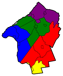
The 26 municipalities of Hunterdon County are represented by three Separate Legislative Districts.[67]
| District | Senator[68] | Assembly[68] | Municipalties |
|---|---|---|---|
| 15th | Shirley Turner (D) | Verlina Reynolds-Jackson (D)
Anthony Verrelli (D) |
East Amwell Township (3,878) , Lambertville (3,822) and West Amwell Township (2,739)
The remainder of this district covers portions of Mercer County. |
| 16th | Christopher Bateman (R) | Andrew Zwicker (D)
Roy Freiman (D) |
Delaware Township (4,435), Flemington (4,608), Raritan Township (22,219),
Readington Township (15,840) and Stockton (614). The remainder of this district covers portions of Mercer County, Middlesex County and Somerset County. |
| 23rd | Michael J. Doherty (R) | John DiMaio (R)
Erik Peterson (R) |
Alexandria Township (4,758), Bethlehem Township (3,855), Bloomsbury (729),
Califon (1,139), Clinton Town (2,686), Clinton Township (12,877), Franklin Township (3,195), Frenchtown (1,464), Glen Gardner (1,704), Hampton Borough (1,401), High Bridge (3,648), Holland Township (5,291), Kingwood Township (3,845), Lebanon Borough (1,358), Lebanon Township (6,588), Millford Borough (1,233), Tewksbury (5,993) and Union Township (5,098). The remainder of this district covers portions of Somerset County and Warren County. |
Politics[]
Hunterdon County is solidly Republican and has traditionally elected some of the most conservative members of the New Jersey legislature. It has also provided big votes for independent conservative third party candidates opposing liberal and moderate Republicans, particularly in 1997, when 13% of county voters backed two conservative independent candidates against incumbent Governor Christine Todd Whitman. Hunterdon supported Steve Lonegan for Governor over Chris Christie in the 2009 Republican Primary, by a 4.0% margin. All five County Freeholders are Republican, as are all countywide elected officers and the majority of township committee and borough council members. The county has only gone Democratic in a presidential election twice since 1920, in the national Democratic landslides of 1936 and 1964.
As of August 1, 2020, there were a total of 102,354 registered voters in Hunterdon County, of which 40,557 (39.6%) were registered as Republicans, 27,823 (27.2%) were registered as Democrats and 33,156 (32.4%) were registered as Unaffiliated. There were 818 (0.8%) voters registered to other parties.[69]
In the 2008 U.S. presidential election, Barack Obama defeated John McCain by a 13.3% margin nationally, but Obama defeated McCain in New Jersey by a 15.5% margin.[70] Republican John McCain received 55.5% of the vote (39,092 cast), ahead of Democrat Barack Obama with 42.3% (29,776 votes) and other candidates with 1.4% (981 votes), among the 70,409 ballots cast by the county's 87,460 registered voters, for a turnout of 80.5%.[71] In the 2004 U.S. presidential election, George W. Bush carried the county by a 20.8% margin over John Kerry, with Kerry carrying the state by 6.7% over Bush.[72] Bush received 60.0% of the vote (39,888 ballots cast), outpolling Democrat John Kerry with 39.2% (26,050 votes) and other candidates with 0.9% (742 votes), among the 66,522 ballots cast by the county's 81,185 registered voters, for a turnout percentage of 81.9.[73]
In the 2009 gubernatorial election, Republican Chris Christie received 64.9% of the vote (33,360 ballots cast), ahead of Democrat Jon Corzine with 25.1% (12,893 votes), Independent Chris Daggett with 8.0% (4,098 votes) and other candidates with 0.8% (387 votes), among the 51,372 ballots cast by the county's 86,186 registered voters, yielding a 59.6% turnout.[74]
However in 2016, the margin of victory for Republican presidential candidates decreased 17.8 percent in 2012 to 13.7 percent, despite the Democrats national popular vote margin shrinking from 3.9 points to 2.1 points. In 2020, Joe Biden came closer than any Democratic nominee to carrying the county since Lyndon B. Johnson’s win in 1964, losing by 4.4 percent to Donald Trump.
Municipalities[]


The following 26 municipalities are located in Hunterdon County (with 2010 Census data for population, housing units and area):[77]
| Municipality (with map key) |
Municipal type |
Population | Housing Units |
Total Area |
Water Area |
Land Area |
Pop. Density |
Housing Density |
Communities[78] | |
|---|---|---|---|---|---|---|---|---|---|---|
| Alexandria Township | 11 | township | 4,938 | 1,865 | 27.64 | 0.22 | 27.42 | 180.1 | 68.0 | Everittstown Little York Mechlings Corner Mount Pleasant Mount Salem Swinesburg |
| Bethlehem Township | 16 | township | 3,979 | 1,386 | 20.83 | 0.12 | 20.71 | 192.1 | 66.9 | Charlestown Polktown Swinesburg West Portal |
| Bloomsbury | 15 | borough | 870 | 358 | 0.91 | 0.03 | 0.88 | 991.9 | 408.1 | |
| Califon | 25 | borough | 1,076 | 419 | 0.97 | 0.02 | 0.95 | 1,133.3 | 441.3 | Lower Valley |
| Clinton (town) | 18 | town | 2,719 | 1,098 | 1.42 | 0.08 | 1.34 | 2,032.6 | 820.8 | |
| Clinton Township | 19 | township | 13,478 | 4,737 | 33.82 | 3.95 | 29.88 | 451.1 | 158.6 | Annandale CDP (1,695) Cedar Heights Cokesbury Hamden Mariannes Corner Potterstown Readingsburg Sunnyside |
| Delaware Township | 4 | township | 4,563 | 1,927 | 37.02 | 0.39 | 36.64 | 124.5 | 52.6 | Bowne Brookville Dilts Corner Headquarters Locktown Prallsville Raven Rock Rosemont Sand Brook Sandy Ridge Sergeantsville |
| East Amwell Township | 3 | township | 4,013 | 1,580 | 28.56 | 0.10 | 28.46 | 141.0 | 55.5 | Amwell Boss Road Bowne Buttonwood Corners Cloverhill Furmans Corner Larisons Corners Linvale Reaville Rileyville Ringoes Rocktown Snydertown Unionville Vanlieu Corners Wertsville |
| Flemington | 8 | borough | 4,581 | 1,926 | 1.08 | 0.00 | 1.08 | 4,252.2 | 1,787.8 | |
| Franklin Township | 10 | township | 3,195 | 1,204 | 23.00 | 0.20 | 22.80 | 140.1 | 52.8 | Allens Corner Alvater Corner Cherryville Grandin Kingtown Lansdowne Littletown Oak Grove Quakertown Sidney Sunnyside |
| Frenchtown | 12 | borough | 1,373 | 656 | 1.36 | 0.10 | 1.26 | 1,087.2 | 519.4 | |
| Glen Gardner | 22 | borough | 1,704 | 825 | 1.52 | 0.00 | 1.52 | 1,117.8 | 541.2 | Bells Crossing Clarksville |
| Hampton | 23 | borough | 1,401 | 612 | 1.54 | 0.01 | 1.53 | 915.1 | 399.7 | Hampton Junction |
| High Bridge | 21 | borough | 3,648 | 1,481 | 2.43 | 0.04 | 2.39 | 1,526.9 | 619.9 | Pierce Heights |
| Holland Township | 14 | township | 5,291 | 2,066 | 24.02 | 0.51 | 23.51 | 225.0 | 87.9 | Amsterdam Hughesville Little York Mount Joy Riegel Ridge Spring Mills |
| Kingwood Township | 6 | township | 3,845 | 1,569 | 35.77 | 0.62 | 35.16 | 109.4 | 44.6 | Barbertown Byram Idell Milltown Point Breeze Tumble Falls |
| Lambertville | 1 | city | 3,914 | 2,079 | 1.30 | 0.14 | 1.15 | 3,386.1 | 1,798.8 | |
| Lebanon | 20 | borough | 1,358 | 664 | 0.89 | 0.00 | 0.89 | 1,532.0 | 749.1 | |
| Lebanon Township | 24 | township | 6,588 | 2,439 | 31.70 | 0.24 | 31.46 | 209.4 | 77.5 | Anthony Bunnvale Hampton Junction Hoffmans Little Brook Lower Valley Mount Lebanon New Hampton Newport Penwell Red Mill Scrappy Corner Spruce Run Woodglen |
| Milford | 13 | borough | 1,233 | 552 | 1.23 | 0.08 | 1.15 | 1,073.4 | 480.5 | |
| Raritan Township | 7 | township | 22,177 | 8,284 | 37.69 | 0.16 | 37.53 | 591.2 | 220.9 | Bartles Corners Cloverhill Copper Hill Croton Flemington Junction Gary Corner Klinesville Larisons Corners Muirhead Reaville Rockefellows Mills Thachers Hill Voorhees Corner |
| Readington Township | 9 | township | 16,126 | 6,191 | 48.04 | 0.30 | 47.74 | 337.8 | 129.7 | Barley Sheaf Centerville Cushetunk Darts Mills Dreahook Holcomb Mills McCrea Mills Mechanicsville Pleasant Run Potterstown Readington Village Riverside Rowland's Mills Stanton Three Bridges Whitehouse Whitehouse Station CDP (2,089) |
| Stockton | 5 | borough | 538 | 259 | 0.61 | 0.08 | 0.54 | 1,005.6 | 484.1 | |
| Tewksbury Township | 26 | township | 5,993 | 2,323 | 31.70 | 0.17 | 31.53 | 190.1 | 73.7 | Bissell Cokesbury Fairmount Farmersville Laurel Farms Lower Fairmount Mountainville Oldwick Sutton Vernoy |
| Union Township | 17 | township | 5,908 | 1,830 | 20.61 | 1.87 | 18.74 | 315.3 | 97.7 | Coles Mills Grandin Hensfoot Jutland Kingtown Mechlings Corner Mount Salem Norton Pattenburg Perryville Polktown Van Syckel |
| West Amwell Township | 2 | township | 2,842 | 1,157 | 21.78 | 0.19 | 21.58 | 177.9 | 53.6 | Alexauken Bowne Linvale Mount Airy Rocktown |
| Hunterdon County | county | 127,351 | 49,487 | 437.44 | 9.62 | 427.82 | 300.0 | 115.7 |
Other unincorporated places[]
Other unincorporated places within Hunterdon County include:
- Pittstown (within Franklin, Union, and Alexandria)
- Pottersville (within Tewksbury and Bedminster [Somerset])
Parks[]
The Hunterdon County Department of Parks and Recreation manages these parks.
- Point Mountain Section
- Mountain Farm/Teetertown Preserve
- Tower Hill Park
- Charlestown Reserve
- Nature Preserve
- Columbia Trail Section
- Cold Brook Reserve
- Musconetcong Gorge Section
- Schick Reserve
- Hoffman Park
- South Branch Reservation
- Landsdown Trail Section
- Cushetunk Mountain Nature Preserve
- Arboretum
- Deer Path Park and Round Mountain Section
- Uplands Reserve
- Clover Hill Park
- Heron Glen Golf Course
- Wescott Nature Preserve
- South County Park
- Future Park
- Laport Reserve
- Sourland Mountain Nature Preserve
- Nature Preserve
- Finn Road Park
Points of interest[]
- Beneduce Vineyards
- Hunterdon County Arboretum
- Hunterdon Art Museum
- Hunterdon County Courthouse
- Hunterdon Medical Center
- Mount Salem Vineyards
- Old York Cellars
- The Red Mill (in Clinton, New Jersey)[79]
- Solitude Dam/TISCO Headquarters 1742 in High Bridge, New Jersey
- The Solitude House Museum in High Bridge, New Jersey
- The Taylor Steelworkers Historic Greenway in High Bridge, New Jersey
- Unionville Vineyards
Notable people[]
- Emma Bell (born 1986), actress
- Scott Bradlee (born 1981), musician
- John Whitfield Bunn and Jacob Bunn, industrialists
- Daryl Cobb (born 1961), children's book author.[80]
- Jack Cust (born 1979), MLB player
- Vera Farmiga (born 1973), Academy Award-nominated actress, film director and television producer[81]
- Taissa Farmiga (born 1994), actress[82]
- Wanda Gág (1893–1946), writer
- Elizabeth Gilbert (born 1969), writer
- Troy Glaus (born 1976), MLB player
- Merv Griffin (1925–2007), musician, talk-show host, television producer
- Liver-Eating Johnson (c. 1824-1900), mountain man of the American West, on whom the film Jeremiah Johnson is based.
- William Kirkpatrick, (1769–1832), United States Congressman
- Leonard Lance (born 1952), United States Congressman
- James W. Marshall (1810–1885), discoverer of gold at Sutter's Mill in California in 1848 (started the Gold Rush)
- Collin McKinney, Texas independence leader
- Joe Piscopo (born 1951), comedian
- Susan Seidelman (born 1952), film director and producer
- Gary Vaynerchuk (born 1975), Entrepreneur
- Christine Todd Whitman (born 1946), 50th Governor of New Jersey
Education[]
High schools[]
- Delaware Valley Regional High School, in Alexandria Township, serves the townships of Alexandria, Holland and Kingwood and the boroughs of Frenchtown and Milford.[83]
- Hunterdon Central Regional High School, located in Raritan Township, serves students from Delaware Township, East Amwell Township, Flemington Borough, Raritan Township and Readington Township.[84]
- North Hunterdon High School, located in Clinton Township, hosts the students of Bethlehem Township, Clinton Town, Clinton Township, Franklin Township, Lebanon Borough and Union Township.[85]
- Phillipsburg High School, located in Phillipsburg in neighboring Warren County, educates the students of Bloomsbury, though a proposal is currently on the table to send the borough's students to Delaware Valley Regional High school instead.[86]
- South Hunterdon Regional High School, located in West Amwell Township, serves students from Lambertville, Stockton and West Amwell Township.[87]
- Voorhees High School, in Lebanon Township, serves the students of Califon Borough, Glen Gardner Borough, Hampton Borough, High Bridge Borough, Lebanon Township, Tewksbury Township.[88]
Higher education[]
- Raritan Valley Community College is the two-year community college for both Hunterdon and Somerset County, one of a network of 19 county colleges statewide. Founded in 1965, the school's main campus is located in North Branch, in Somerset County.[89]
- Rutgers University has a partnership with Raritan Valley Community College which offers bachelor's degree completion programs at the North Branch campus.[90]
Climate and weather[]
| Flemington, New Jersey | ||||||||||||||||||||||||||||||||||||||||||||||||||||||||||||
|---|---|---|---|---|---|---|---|---|---|---|---|---|---|---|---|---|---|---|---|---|---|---|---|---|---|---|---|---|---|---|---|---|---|---|---|---|---|---|---|---|---|---|---|---|---|---|---|---|---|---|---|---|---|---|---|---|---|---|---|---|
| Climate chart (explanation) | ||||||||||||||||||||||||||||||||||||||||||||||||||||||||||||
| ||||||||||||||||||||||||||||||||||||||||||||||||||||||||||||
| ||||||||||||||||||||||||||||||||||||||||||||||||||||||||||||
In recent years, average temperatures in the county seat of Flemington have ranged from a low of 19 °F (−7 °C) in January to a high of 85 °F (29 °C) in July, although a record low of −18 °F (−28 °C) was recorded in January 1984 and a record high of 106 °F (41 °C) was recorded in July 1936. Average monthly precipitation ranged from 3.16 inches (80 mm) in February to 5.16 inches (131 mm) in July.[91]
See also[]
- The Hunterdon County Democrat
- National Register of Historic Places listings in Hunterdon County, New Jersey
- USS Hunterdon County (LST-838)
- Musconetcong County, New Jersey, a proposed county in the 19th Century from parts of Hunterdon and Warren counties
References[]
- ^ Jump up to: a b New Jersey County Map Archived March 13, 2017, at the Wayback Machine, New Jersey Department of State. Accessed July 10, 2017.
- ^ QuickFacts - Hunterdon County, New Jersey; New Jersey; United States Archived April 30, 2018, at the Wayback Machine, United States Census Bureau. Accessed March 24, 2018.
- ^ Annual Estimates of the Resident Population: April 1, 2010 to July 1, 2018 - 2018 Population Estimates Archived February 13, 2020, at archive.today, United States Census Bureau. Accessed March 24, 2018.
- ^ GCT-PEPANNCHG: Estimates of Resident Population Change and Rankings: July 1, 2017 to July 1, 2018 - State -- County / County Equivalent from the 2017 Population Estimates for New Jersey Archived February 13, 2020, at archive.today, United States Census Bureau. Accessed March 24, 2018.
- ^ Jump up to: a b c d e DP1 - Profile of General Population and Housing Characteristics: 2010 Demographic Profile Data for Hunterdon County, New Jersey, United States Census Bureau. Accessed March 26, 2016.
- ^ Jump up to: a b c d e DP-1 - Profile of General Demographic Characteristics: 2000; Census 2000 Summary File 1 (SF 1) 100-Percent Data for Hunterdon County, New Jersey, United States Census Bureau. Accessed January 21, 2013.
- ^ [lwd.dol.state.nj.us/labor/lpa/industry/incpov/highcnty.xls 250 Highest Per Capita Personal Incomes available for 3113 counties in the United States: 2015], New Jersey Department of Labor and Workforce Development. Accessed October 24, 2017.
- ^ Local Area Personal Income: 2015 Archived October 15, 2017, at the Wayback Machine, Bureau of Economic Analysis. Accessed October 24, 2017.
- ^ 250 Highest Per Capita Personal Incomes of the 3113 Counties in the United States, 2009 Archived December 12, 2011, at the Wayback Machine, Bureau of Economic Analysis. Hunterdon has the highest per capita personal income for counties with under 250,000 people. Accessed April 9, 2012.
- ^ Small Area Income and Poverty Estimates - Table 1: 2011 Poverty and Median Income Estimates - Counties Archived October 10, 2013, at the Wayback Machine, United States Census Bureau. Accessed January 8, 2015.
- ^ "Revised Delineations of Metropolitan Statistical Areas, Micropolitan Statistical Areas, and Combined Statistical Areas, and Guidance on Uses of the Delineations of These Areas", OMB Bulletin no. 18-04, The White House, Office of Management and Budget, September 4, 2018
- ^ Jump up to: a b c d e Snyder, John P. The Story of New Jersey's Civil Boundaries: 1606-1968 Archived June 5, 2012, at the Wayback Machine, Bureau of Geology and Topography; Trenton, New Jersey; 1969. p. 153. Accessed May 30, 2012.
- ^ Jump up to: a b Fun Facts Archived September 27, 2007, at the Wayback Machine, Hunterdon County, New Jersey. Accessed October 5, 2013.
- ^ Gannett, Henry (1905). The Origin of Certain Place Names in the United States. Govt. Print. Off. p. 163.
- ^ Shupe, Lillian. "What's with this? Walpack Township once part of Hunterdon Archived April 23, 2012, at the Wayback Machine, Hunterdon County Democrat, April 19, 2012. Accessed May 30, 2012. "At one time Hunterdon County, the second county to be established in New Jersey, extended as far south as Trenton and as far north as the New York State line which at that time was about 10 miles north of Port Jervis, N.Y. Hunterdon County was named for Robert Hunter, a colonial governor of New Jersey. His former home in England was called Hunterston but over time the name was changed to Hunterdon."
- ^ Varde, S. (1998). "Prevalence of tick-borne pathogens in Ixodes scapularis in a rural New Jersey County". Emerging Infectious Diseases. 4 (1): 97–99. doi:10.3201/eid0401.980113. PMC 2627663. PMID 9452402.
- ^ Deak, Mike. "Hunterdon County Library users will have access to millions more items". MyCentralJersey.com. Retrieved January 5, 2021.
- ^ Census 2010 U.S. Gazetteer Files: New Jersey Counties, United States Census Bureau, Backed up by the Internet Archive as of June 11, 2012. Accessed October 5, 2013.
- ^ New Jersey County High Points Archived May 18, 2015, at the Wayback Machine, Peakbagger.com. Accessed October 5, 2013.
- ^ Areas touching Hunterdon County Archived January 8, 2015, at the Wayback Machine, MapIt. Accessed January 8, 2015.
- ^ Wildlife, NJ Division of Fish and. "NJDEP Division of Fish & Wildlife - White-tailed Deer in New Jersey". www.state.nj.us. Archived from the original on October 21, 2017. Retrieved October 21, 2017.
- ^ Round Valley Recreation Area Archived May 27, 2010, at the Wayback Machine, New Jersey Department of Environmental Protection Division of Parks and Forestry. Accessed October 24, 2017. "The Round Valley Reservoir swimming area was created by the construction of an earth dam across a narrow waterway on the west side of the reservoir, separating it from the main part of the reservoir. The reservoir covers over 2,000 acres and is approximately 180 feet deep, the deepest lake in New Jersey. It has a water capacity of 55 billion gallons."
- ^ Spruce Run Recreation Area Archived June 12, 2010, at the Wayback Machine, New Jersey Department of Environmental Protection Division of Parks and Forestry. Accessed October 24, 2017. "The reservoir was one of the first water supply facilities to be constructed and operated by the state and covers 1,290 acres with 15 miles of shoreline for recreation. Spruce Run is the third largest reservoir in the state after Round Valley and Wanaque reservoirs."
- ^ Wildlife Management Areas Archived November 24, 2015, at the Wayback Machine, New Jersey Department of Environmental Protection Division of Fish and Wildlife. Accessed October 24, 2017.
- ^ Local Area Gross Domestic Product, 2018, Bureau of Economic Analysis, released December 12, 2019. Accessed December 12, 2019.
- ^ Suburbs Near NYC Have Highest Tax Bills, Newsday, October 4, 2006 Archived March 10, 2007, at the Wayback Machine
- ^ Property Taxes on Owner Occupied Housing by County, 2005 Archived January 24, 2007, at the Wayback Machine, Tax Foundation. Accessed October 4, 2006.
- ^ Woolsey, Matt. "America's Priciest Property Taxes" Archived August 23, 2017, at the Wayback Machine, Forbes, October 3, 2007. Accessed January 11, 2008. "The hardest hit? Homeowners in western New Jersey's Hunterdon County. Last year, the median yearly property tax bill amounted to a whopping $7,999 here, according to the Tax Foundation, a nonpartisan research group in Washington, D.C, which compiled data based on 2006 figures."
- ^ New York, New Jersey Homeowners Nation's Hardest Hit by Property Taxes Archived October 26, 2008, at the Wayback Machine, Tax Foundation press release dated September 12, 2007. Accessed January 11, 2008.
- ^ Staff. "Hunterdon County, N.J., Has Highest Taxes" Archived May 12, 2014, at the Wayback Machine, Bloomberg, May 17, 2011. Accessed October 5, 2013. "Residents of New Jersey's Hunterdon County pay the highest property taxes in the U.S., according to the Tax Foundation. The annual median property tax in Hunterdon, about 60 miles (97 kilometers) southwest of Manhattan near the Delaware River, was $8,216, a report issued today by the Washington-based organization shows."
- ^ "Population and Housing Unit Estimates". Retrieved July 25, 2019.
- ^ Forstall, Richard L. Population of states and counties of the United States: 1790 to 1990 from the Twenty-one Decennial Censuses, pp. 108-109. United States Census Bureau, March 1996. ISBN 9780934213486. Accessed October 3, 2013.
- ^ New Jersey: 2010 - Population and Housing Unit Counts; 2010 Census of Population and Housing Archived July 23, 2013, at the Wayback Machine, p. 6, CPH-2-32. United States Census Bureau, August 2012. Accessed August 29, 2016.
- ^ U.S. Census website , United States Census Bureau. Accessed September 4, 2014.
- ^ Jump up to: a b c Tables DP-1 to DP-4 from Census 2000 for Somerset County, New Jersey, United States Census Bureau, backed up by the Internet Archive as of July 24, 2008. Accessed October 5, 2013.
- ^ DP-2 - Profile of Selected Social Characteristics: 2000 from the Census 2000 Summary File 3 (SF 3) - Sample Data for Hunterdon County, New Jersey, United States Census Bureau. Accessed September 30, 2013.
- ^ DP-3 - Profile of Selected Economic Characteristics: 2000 from Census 2000 Summary File 3 (SF 3) - Sample Data for Hunterdon County, New Jersey, United States Census Bureau. Accessed September 30, 2013.
- ^ Hunterdon County Mileage by Municipality and Jurisdiction Archived September 24, 2015, at the Wayback Machine, New Jersey Department of Transportation, May 2010. Accessed July 18, 2014.
- ^ Hunterdon County Bus / Rail Connections, NJ Transit, backed up by the Internet Archive as of July 26, 2010. Accessed September 20, 2012.
- ^ Hunterdon County Freight Profile Archived October 24, 2017, at the Wayback Machine, North Jersey Transportation Planning Authority. Accessed October 24, 2017. "On the rail network, the Norfolk Southern Lehigh Line, which runs across the County, is one of the most heavily - traveled freight rail lines in the State."
- ^ "Hunterdon County LINK Transportation". www.ridethelink.com. Archived from the original on March 7, 2018. Retrieved April 30, 2018.
- ^ NYC PABT -- Eastbound Archived October 23, 2017, at the Wayback Machine, Trans-Bridge Lines. Accessed October 22, 2017.
- ^ About the Board Archived February 5, 2007, at the Wayback Machine, Hunterdon County, New Jersey. Accessed October 22, 2017.
- ^ Gallo Jr., Bill. "Which N.J. county freeholders are paid the most?" Archived October 26, 2017, at the Wayback Machine, NJ.com, March 11, 2016. Accessed October 25, 2017. "Freeholder director: $17,000; Other freeholders: $16,000"
- ^ Hunterdon County Board of Chosen Freeholders Archived October 6, 2012, at the Wayback Machine, Hunterdon County, New Jersey. Accessed October 22, 2017.
- ^ 2017 County Data Sheet Archived June 6, 2017, at the Wayback Machine, Hunterdon County, New Jersey. Accessed October 22, 2017.
- ^ John E. Lanza Archived January 8, 2015, at the Wayback Machine, Hunterdon County, New Jersey. Accessed October 22, 2017.
- ^ John King Archived October 4, 2013, at the Wayback Machine, Hunterdon County, New Jersey. Accessed October 22, 2017.
- ^ Matt Holt Archived February 6, 2007, at the Wayback Machine, Hunterdon County, New Jersey. Accessed October 22, 2017.
- ^ Suzanne Lagay Archived January 8, 2015, at the Wayback Machine, Hunterdon County, New Jersey. Accessed October 22, 2017.
- ^ Robert G. Walton Archived January 2, 2011, at the Wayback Machine, Hunterdon County, New Jersey. Accessed October 22, 2017.
- ^ New Jersey State Constitution (1947), Article VII, Section II, Paragraph 2 Archived November 1, 2014, at the Wayback Machine, New Jersey Department of State. Accessed October 26, 2017.
- ^ Elected and Appointed Officials Archived October 4, 2013, at the Wayback Machine, Hunterdon County, New Jersey. Accessed October 22, 2017.
- ^ 2017 County and Municipal Guide Archived July 7, 2017, at the Wayback Machine, Hunterdon County, New Jersey. Accessed October 22, 2017.
- ^ Members List: Clerks Archived October 23, 2017, at the Wayback Machine, Constitutional Officers Association of New Jersey. Accessed October 22, 2017.
- ^ Hunterdon County Clerk Mary H. Melfi Archived August 14, 2013, at the Wayback Machine, Hunterdon County, New Jersey. Accessed October 22, 2017.
- ^ Frederick W. Brown; Hunterdon County Sheriff Archived August 14, 2013, at the Wayback Machine, Hunterdon County, New Jersey. Accessed October 22, 2017.
- ^ Members List: Sheriffs Archived October 23, 2017, at the Wayback Machine, Constitutional Officers Association of New Jersey. Accessed October 22, 2017.
- ^ Surrogate Susan J. Hoffman Archived August 14, 2013, at the Wayback Machine, Hunterdon County, New Jersey. Accessed October 22, 2017.
- ^ Members List: Surrogates Archived October 23, 2017, at the Wayback Machine, Constitutional Officers Association of New Jersey. Accessed October 22, 2017.
- ^ Message from the Prosecutor Archived October 25, 2017, at the Wayback Machine, Hunterdon County, New Jersey. Accessed October 24, 2017.
- ^ Governor Chris Christie Files Nominations Archived October 25, 2017, at the Wayback Machine, Governor of New Jersey Chris Christie, press release dated September 8, 2016. Accessed October 24, 2017. "Hunterdon County Prosecutor - Nominate for reappointment Anthony P. Kearns, III (Clinton, Hunterdon)"
- ^ Somerset/Hunterdon/Warren Vicinage Archived October 11, 2017, at the Wayback Machine, New Jersey Courts. Accessed October 22, 2017.
- ^ 2012 Congressional Districts by County Archived May 26, 2012, at the Wayback Machine, New Jersey Department of State Division of Elections. Accessed October 5, 2013.
- ^ Plan Components Report Archived December 4, 2013, at the Wayback Machine, New Jersey Department of State Division of Elections, December 23, 2011. Accessed October 5, 2013.
- ^ Directory of Representatives: New Jersey, United States House of Representatives. Accessed June 1, 2020.
- ^ "MUNICIPALITIES". Hunterdon County. Retrieved May 3, 2021.
- ^ Jump up to: a b "New Jersey Legislature - Legislative Roster". www.njleg.state.nj.us. Retrieved May 3, 2021.
- ^ "NJ Voter Registration by County" (PDF). NJ DOS - NJ Division of Elections.
- ^ Leip, David. "Dave Leip's Atlas of U.S. Presidential Elections". www.uselectionatlas.org. Archived from the original on July 22, 2010. Retrieved April 30, 2018.
- ^ 2008 Presidential General Election Results: Hunterdon County Archived August 1, 2013, at the Wayback Machine, New Jersey Department of State Division of Elections, December 23, 2008. Accessed January 8, 2015.
- ^ New Jersey Presidential Election Returns by County 2004 Archived September 14, 2008, at the Wayback Machine, Eagleton Institute of Politics at Rutgers University. Accessed August 31, 2008.
- ^ 2004 Presidential Election: Hunterdon County Archived August 1, 2013, at the Wayback Machine, New Jersey Department of State Division of Elections, December 13, 2004. Accessed January 8, 2015.
- ^ 2009 Governor: Hunterdon County Archived October 17, 2012, at the Wayback Machine, New Jersey Department of State Division of Elections, December 31, 2009. Accessed January 8, 2015.
- ^ Leip, David. "Dave Leip's Atlas of U.S. Presidential Elections". uselectionatlas.org. Archived from the original on March 23, 2018. Retrieved April 30, 2018.
- ^ http://geoelections.free.fr/. Retrieved January 13, 2021. Missing or empty
|title=(help) - ^ GCT-PH1: Population, Housing Units, Area, and Density: 2010 – County – County Subdivision and Place from the 2010 Census Summary File 1 for Hunterdon County, New Jersey, United States Census Bureau. Accessed March 25, 2017.
- ^ Locality Search Archived July 9, 2016, at the Wayback Machine, State of New Jersey. Accessed March 25, 2017.
- ^ The Red Mill in Operation: 1810 - 1928 Archived November 8, 2015, at the Wayback Machine, Red Mill Museum Village. Accessed October 27, 2017.
- ^ Hunterdon County Democrat (March 27, 2010). "Children's author Daryl Cobb returns to Hampton". Hunterdon County Democrat. Hunterdon County Democrat. Hunterdon County Democrat. Archived from the original on June 27, 2015. Retrieved June 26, 2015.
- ^ Bonelli, Winnie (March 15, 2010). "Veering Toward Stardom". New Jersey Monthly. Archived from the original on December 22, 2014.
- ^ Blasberg, Derek (July 5, 2012). "Drew's Angels - Taissa Farmiga". V Magazine. Archived from the original on July 6, 2015. Retrieved May 12, 2015.
- ^ Delaware Valley Regional High School District 2016 Report Card Narrative Archived April 7, 2017, at the Wayback Machine, New Jersey Department of Education. Accessed October 27, 2017. "The Delaware Valley Regional High School District can be found in the heart of pastoral and beautiful Hunterdon County, New Jersey. The District serves students in grades nine through twelve who reside in the five municipalities that comprise our region: Alexandria Township, Frenchtown Borough, Holland Township, Kingwood Township, and Milford Borough."
- ^ Hunterdon Central Regional High School District 2016 Report Card Narrative Archived September 26, 2017, at the Wayback Machine, New Jersey Department of Education. Accessed March 24, 2018. "Located in beautiful, historic Hunterdon County in central New Jersey, Hunterdon Central Regional High School serves the five municipalities of Delaware Township, East Amwell Township, Flemington Borough, Raritan Township and Readington Township. The District is comprised of 152.5 square miles and has a population of approximately 51,468 residents."
- ^ About the North Hunterdon-Voorhees Regional High School District Archived February 6, 2015, at the Wayback Machine, North Hunterdon-Voorhees Regional High School District. Accessed October 27, 2017. "North Hunterdon High School educates students from: Bethlehem Township, The Town of Clinton, Clinton Township, Franklin Township, Lebanon Borough, Union Township"
- ^ Petty, Todd. "Bloomsbury school board will consider ending relationship with Phillipsburg High School tomorrow night" Archived October 11, 2012, at the Wayback Machine, The Warren Reporter, October 8, 2012. Accessed October 27, 2017. "The Board of Education will vote to decide whether it wants to continue sending students to Phillipsburg High School at a meeting tomorrow night. The agenda for tomorrow night's meeting includes a resolution 'approving the filing of petition to sever send/receive relationship between the Bloomsbury Board of Education and the Phillipsburg Board of Education.'"
- ^ South Hunterdon Regional School District 2016 Report Card Narrative Archived October 27, 2017, at the Wayback Machine, New Jersey Department of Education. Accessed October 27, 2017. "Bordering the Delaware River and located in the culturally rich and rural region of Southern Hunterdon County, SHRSD serves the communities of Lambertville, Stockton, and West Amwell."
- ^ Voorhees High School 2016 Report Card Narrative Archived October 27, 2017, at the Wayback Machine, New Jersey Department of Education. Accessed October 27, 2017. "Voorhees High School has consistently ranked among the top high schools in New Jersey and was named a National Blue Ribbon School in 2015. With an enrollment of 1,087 students in grades 9-12, the school serves the communities of Califon, Glen Gardner, Hampton, High Bridge, Lebanon Township, and Tewksbury Township."
- ^ History, Mission & Core Values Archived April 24, 2012, at the Wayback Machine, Raritan Valley Community College. Accessed May 30, 2012.
- ^ About Raritan Valley Archived July 31, 2012, at the Wayback Machine, Rutgers University. Accessed May 30, 2012.
- ^ Jump up to: a b "Monthly Averages for Flemington, New Jersey". The Weather Channel. Archived from the original on December 7, 2009. Retrieved October 13, 2012.
External links[]
 Media related to Hunterdon County, New Jersey at Wikimedia Commons
- Hunterdon County Official Website
- Map of Hunterdon County
- Hunterdon Land Trust Alliance
- HunterdonCountry.com
- River Ballet Company
- Hunterdon County Obituary Collection
- Hunterdon County Chamber of Commerce Website
- NY-NJTC: Teetertown Ravine Nature Preserve Trail Details and Info
- Hunterdon County Library
- Hunterdon County Alive - Community Website
- Hunterdon Happening Magazine
| show Places adjacent to Hunterdon County, New Jersey |
|---|
| show Municipalities and communities of Hunterdon County, New Jersey, United States |
|---|

| show |
|---|
| show New York metropolitan area |
|---|

| show Authority control |
|---|
- New Jersey counties
- Hunterdon County, New Jersey
- 1714 establishments in New Jersey
- Central Jersey
- Counties in the New York metropolitan area
- Populated places established in 1714