Igel
Igel | |
|---|---|
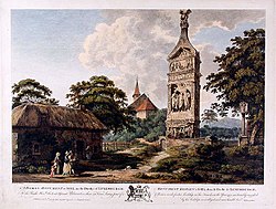 A Roman Monument at Igel, coloured engraving published by John Boydell from a painting by Edward Rooker | |
 Coat of arms | |
show Location of Igel within Trier-Saarburg district | |
 Igel | |
| Coordinates: 49°42′36″N 6°32′53″E / 49.71000°N 6.54806°ECoordinates: 49°42′36″N 6°32′53″E / 49.71000°N 6.54806°E | |
| Country | Germany |
| State | Rhineland-Palatinate |
| District | Trier-Saarburg |
| Municipal assoc. | Trier-Land |
| Government | |
| • Mayor (2019–24) | Franz Pauly[1] (CDU) |
| Area | |
| • Total | 7.30 km2 (2.82 sq mi) |
| Elevation | 164 m (538 ft) |
| Population (2020-12-31)[2] | |
| • Total | 2,092 |
| • Density | 290/km2 (740/sq mi) |
| Time zone | UTC+01:00 (CET) |
| • Summer (DST) | UTC+02:00 (CEST) |
| Postal codes | 54298 |
| Dialling codes | 06501 |
| Vehicle registration | TR |
| Website | www.gemeinde-igel.de |


Igel is a municipality in the Trier-Saarburg district, in Rhineland-Palatinate, Germany. Igel is known for the Igel Column, a 23 m high Roman decorated tomb. The Igel Column is a UNESCO World Heritage Site.

Igel Column

The "Grutenhäuschen" a partly reconstructed Roman tomb in the vineyards near Igel.
References[]
- ^ Direktwahlen 2019, Landkreis Trier-Saarburg, Landeswahlleiter Rheinland-Pfalz, accessed 2 August 2021.
- ^ "Bevölkerungsstand 2020, Kreise, Gemeinden, Verbandsgemeinden". Statistisches Landesamt Rheinland-Pfalz (in German). 2021.
| show Towns and municipalities in Trier-Saarburg |
|---|
| show Authority control |
|---|
This Trier-Saarburg location article is a stub. You can help Wikipedia by . |
Categories:
- Municipalities in Rhineland-Palatinate
- Trier-Saarburg
- Trier-Saarburg geography stubs