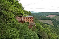
Kastel-Staadt
Kastel-Staadt | |
|---|---|
 | |
 Coat of arms | |
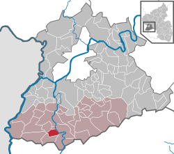
show Location of Kastel-Staadt within Trier-Saarburg district | |
 Kastel-Staadt | |
| Coordinates: 49°33′53″N 6°33′35″E / 49.56472°N 6.55972°ECoordinates: 49°33′53″N 6°33′35″E / 49.56472°N 6.55972°E | |
| Country | Germany |
| State | Rhineland-Palatinate |
| District | Trier-Saarburg |
| Municipal assoc. | Saarburg-Kell |
| Government | |
| • Mayor (2019–24) | Reiner Schmitt[1] |
| Area | |
| • Total | 5.23 km2 (2.02 sq mi) |
| Elevation | 330 m (1,080 ft) |
| Population (2020-12-31)[2] | |
| • Total | 437 |
| • Density | 84/km2 (220/sq mi) |
| Time zone | UTC+01:00 (CET) |
| • Summer (DST) | UTC+02:00 (CEST) |
| Postal codes | 54441 |
| Dialling codes | 06582 |
| Vehicle registration | TR |
| Website | www.kastel-staadt.de |


Kastel-Staadt is a municipality in the Trier-Saarburg district, in Rhineland-Palatinate, Germany.
History[]
From 18 July 1946 to 6 June 1947 Kastel-Staad, in its then municipal boundary, formed part of the Saar Protectorate.
References[]
- ^ Direktwahlen 2019, Landkreis Trier-Saarburg, Landeswahlleiter Rheinland-Pfalz, accessed 2 August 2021.
- ^ "Bevölkerungsstand 2020, Kreise, Gemeinden, Verbandsgemeinden". Statistisches Landesamt Rheinland-Pfalz (in German). 2021.
| show Towns and municipalities in Trier-Saarburg |
|---|
| Authority control |
|---|
This Trier-Saarburg location article is a stub. You can help Wikipedia by . |
Categories:
- Municipalities in Rhineland-Palatinate
- Trier-Saarburg
- Trier-Saarburg geography stubs