Illawarra Escarpment State Conservation Area
| Illawarra Escarpment State Conservation Area New South Wales | |
|---|---|
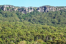 the escarpment near Austinmer | |
 Illawarra Escarpment State Conservation Area | |
| Nearest town or city | Wollongong |
| Coordinates | 34°17′46″S 150°55′38″E / 34.296155°S 150.927276°ECoordinates: 34°17′46″S 150°55′38″E / 34.296155°S 150.927276°E |
| Established | |
| Area | 2,772 hectares |
| Managing authorities | NSW National Parks and Wildlife Service |
| Website | Illawarra Escarpment State Conservation Area |

The Illawarra Escarpment State Conservation Area is a protected area located west of Wollongong in eastern Australia. The conservation area is a popular location for recreation, including bush walking, scenic viewing, picnicking, camping, bird watching, rock climbing and horse riding. The park comprises six separate sections extending over 40 kilometres, from Stanwell Park in the north to Horsely in the south.[1][2][3]
The 30-million-year-old site was inhabited by the Wodi Wodi for 20,000 years, and some of the summits in the region are of spiritual significance for the local Aboriginal people. It also has many colonial roads which were built by Surveyor-General Thomas Mitchell and convicts during 1834.[4]
See also[]
- Illawarra Escarpment
References[]
- ^ "Illawarra Escarpment State Conservation Area". New South Wales Government. Retrieved 13 May 2019.
- ^ "Plan of Management - Illawarra Escarpment State Conservation Area". New South Wales Government. Retrieved 13 May 2019.
- ^ "Illawarra Escarpment State Conservation Area". Visit New South Wales. Retrieved 13 May 2019.
- ^ "Illawarra Escarpment State Conservation Area". NSW National Parks and Wildlife Service.
This New South Wales protected areas related article is a stub. You can help Wikipedia by . |
- State conservation areas in New South Wales
- Forests of New South Wales
- Protected areas established in 1980
- 1980 establishments in Australia
- New South Wales protected area stubs