Independencia District, Huaraz
Independencia | |
|---|---|
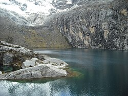 Churup Lake, Independencia District | |
 Coat of arms | |
| Country | |
| Region | Ancash |
| Province | Huaraz |
| Founded | November 16, 1992 |
| Capital | Centenario |
| Government | |
| • Mayor | Gregorio Emiliano Mezarina Paredes |
| Area | |
| • Total | 342.95 km2 (132.41 sq mi) |
| Elevation | 3,049 m (10,003 ft) |
| Population (2005 census) | |
| • Total | 61,705 |
| • Density | 180/km2 (470/sq mi) |
| Time zone | UTC-5 (PET) |
| UBIGEO | 020105 |
Independencia District is one of twelve districts of the province Huaraz in Peru.[1]
Geography[]
The Cordillera Blanca traverses the district. Some of the highest peaks of the district are Pallqarahu, Pukaranra, Ranrapallqa and Rurichinchay. Other mountains are listed below:[2]
See also[]
- Pallqaqucha
- Qillqaywank'a
- Tullpaqucha
- Willkawayin
References[]
- ^ (in Spanish) Instituto Nacional de Estadística e Informática. Banco de Información Distrital Archived 2008-04-23 at the Wayback Machine. Retrieved April 11, 2008.
- ^ escale.minedu.gob.pe - UGEL map of the Huaraz Province (Ancash Region)
Coordinates: 9°30′53″S 77°31′39″W / 9.5146°S 77.5275°W

This Ancash Region geography article is a stub. You can help Wikipedia by . |
Categories:
- Districts of the Huaraz Province
- Districts of the Ancash Region
- Ancash Region geography stubs