San Marcos District
San Marcos | |
|---|---|
 San Marcos | |
| Country | |
| Region | Ancash |
| Province | Huari |
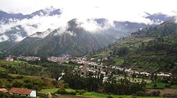
| Capital | San Marcos |
| Government | |
| • Mayor | Christian John Palacios Laguna |
| Area | |
| • Total | 556.75 km2 (214.96 sq mi) |
| Elevation | 2,964 m (9,724 ft) |
| Population (2017) | |
| • Total | 17,033 |
| • Density | 31/km2 (79/sq mi) |
| Time zone | UTC-5 (PET) |
| UBIGEO | 021014 |
San Marcos District is one of sixteen districts of the Huari Province in Peru.[1]
Geography[]
One of the highest peaks of the district is Pukarahu at approximately 5,000 m (16,000 ft). Other mountains are listed below:[2]
- Allpa Qucha
- Anku
- Atuq
- Awaq Wank'a
- Chakaq Munti
- Hatun Chakra
- Hatun Punta
- Ichik Challwa
- Iskay Wank'a
- Isku Punta
- Kinwa Hirka
- Kunkayuq
- Kunkush
- Kuta Kancha
- K'ara K'ara
- Millwa Pillu
- Purway Kinwa
- Puywan
- Qacha Kancha
- Qucha Pata
- Rukutu
- Tampu
- Tankan
- Tullu Qallpa
- T'uqu
- Uqsha Tuna
- Urqu Pintay
- Waman Wayi
- Yanaqucha
- Yuraq Mach'ay
- Yuraq Wank'a
Ethnic groups[]
The people in the district are mainly indigenous citizens of Quechua descent. Quechua is the language which the majority of the population (72.16%) learnt to speak in childhood, 27.31% of the residents started speaking using the Spanish language (2007 Peru Census).[3]
References[]
- ^ (in Spanish) Instituto Nacional de Estadística e Informática. Banco de Información Distrital Archived 2008-04-23 at the Wayback Machine. Retrieved April 11, 2008.
- ^ escale.minedu.gob.pe/ UGEL map Huari Province (Ancash Region)
- ^ inei.gob.pe Archived 2013-01-27 at the Wayback Machine INEI, Peru, Censos Nacionales 2007, Frequencias: Preguntas de Población: Idioma o lengua con el que aprendió hablar (in Spanish)
| show |
|---|
| show Authority control |
|---|
Coordinates: 9°31′01″S 77°13′59″W / 9.51694°S 77.23306°W

This Ancash Region geography article is a stub. You can help Wikipedia by . |
Categories:
- Districts of the Huari Province
- Districts of the Ancash Region
- Ancash Region geography stubs