Indre (river)
| Indre | |
|---|---|
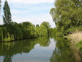 The Indre near Rigny-Ussé | |
 | |
| Native name | L'Indre (f) (French) |
| Location | |
| Country | France |
| Physical characteristics | |
| Source | |
| • location | near Préveranges, Cher |
| • elevation | 504 m (1,654 ft) |
| Mouth | |
• location | Loire |
• coordinates | 47°14′2″N 0°11′0″E / 47.23389°N 0.18333°ECoordinates: 47°14′2″N 0°11′0″E / 47.23389°N 0.18333°E |
| Length | 279.3 km (173.5 mi) |
| Basin size | 3,462 km2 (1,337 sq mi) |
| Discharge | |
| • average | 19 m3/s (670 cu ft/s) |
| Basin features | |
| Progression | Loire→ Atlantic Ocean |

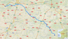
The Indre (French pronunciation: [ɛ̃dʁ] (![]() listen)) is a 279.3 km (173.5 mi) long river in central France, a left tributary to the Loire.[1]
listen)) is a 279.3 km (173.5 mi) long river in central France, a left tributary to the Loire.[1]
Its source is in the department of Cher, near Préveranges. It flows through the departments of Cher, Indre and Indre-et-Loire. It flows generally northwest, through the communes of La Châtre, Châteauroux and Loches.
It joins the Loire near the site of the Chinon nuclear power plant, north of Avoine.
Its main tributary is the Indrois, which joins at Azay-sur-Indre.
Departments and towns along the river:
References[]
External links[]
| Wikimedia Commons has media related to Indre River. |
| Authority control |
|---|
Categories:
- Tributaries of the Loire
- Rivers of France
- Rivers of Cher (department)
- Rivers of Indre
- Rivers of Indre-et-Loire
- Rivers of Centre-Val de Loire
- Centre-Val de Loire geography stubs
- France river stubs