Jõelähtme Parish
Jõelähtme Parish
Jõelähtme vald | |
|---|---|
 Jägala waterfall | |
 Flag  Coat of arms | |
 Jõelähtme Parish within Harju County. | |
| Country | Estonia |
| County | Harju County |
| Administrative centre | Jõelähtme |
| Government | |
| • Mayor | Andrus Umboja |
| Area | |
| • Total | 210.86 km2 (81.41 sq mi) |
| Population (01.01.2020) | |
| • Total | 6,547 |
| ISO 3166 code | EE-245 |
| Website | www.joelahtme.ee |
Jõelähtme Parish (Estonian: Jõelähtme vald) is a rural municipality in Harju County, north-western Estonia. It had a population of 5,351 (as of 1 January 2012) and an area of 210.86 km2 (81.41 sq mi), the population density is 25.3770/km2 (65.726/sq mi)[2]
The administrative centre of Jõelähtme Parish is Jõelähtme village. It is located 20 km east from the centre of Estonia's capital, Tallinn.
History[]
Established in 1816.
During World War II, 6,000 Jews and Roma were murdered by Estonian Nazi collaborators under German supervision. Mass executions were carried out on sand dunes called Kalevi-Liiva where a memorial has been erected.
Local government[]
Current mayor (vallavanem) is Andrus Umboja[3] and chairman of the council (volikogu esimees) is Art Kuum.[4]
Geography[]
Settlements[]
There are 2 small boroughs (est: alevikud, sg. - alevik) and 34 villages (est: külad, sg. - küla) in Jõelähtme Parish.
Small boroughs: Kostivere, Loo.
Villages: Aruaru, Haapse, Haljava, Ihasalu, Iru, Jägala, Jägala-Joa, Jõelähtme, Jõesuu, Kaberneeme, Kallavere, Koila, Koipsi, Koogi, Kostiranna, Kullamäe, Liivamäe, Loo, Maardu, Manniva, Neeme, Nehatu, Parasmäe, Rammu, Rebala, Rohusi, Ruu, Saha, Sambu, Saviranna, Ülgase, Uusküla, Vandjala, Võerdla.
Landmarks[]

- Jägala Waterfall
- Rebala Heritage Reserve
- Kostivere karst area
- Jõelähtme church
- Kaberneeme beach
- Kalevi-Liiva memorial
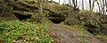
- Ülgase caves
Gallery[]
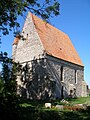
Saha chapel

Bronze Age stone cist graves
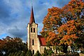
Jõelähtme church
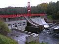
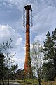
Linnamäe hydroelectric power plant

Memorial at Kalevi-Liiva

Monument to the Estonian War of Independence

Maardu manor house
Ülgase caves

Rammu Island

Mouth of the Jägala river


References[]
- ^ "Elanike arv - Eesti Linnade ja Valdade Liit".
- ^ "Population figure and composition". Statistics Estonia. Retrieved 9 June 2012.
- ^ "Vallavalitsus" (in Estonian). Jõelähtme Vallavalitsus. Retrieved 11 December 2009.
- ^ "Vallavolikogu koosseis" (in Estonian). Jõelähtme Vallavalitsus. Retrieved 11 December 2009.
External links[]
- Official website (in Estonian)
- Map of Jõelähtme Parish
- Non-official public forum (in Estonian)

- Jõelähtme Parish
- Municipalities of Estonia
- Holocaust locations in Estonia