Jabłowo
Jabłowo | |
|---|---|
Village | |
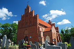 Saint Lawrence church in Jabłowo | |
 Jabłowo | |
| Coordinates: 53°55′33″N 18°34′35″E / 53.92583°N 18.57639°E | |
| Country | |
| Voivodeship | Pomeranian |
| County | Starogard |
| Gmina | Gmina Starogard Gdański |
| Population | 803 |
| Time zone | UTC+1 (CET) |
| • Summer (DST) | UTC+2 (CEST) |


Jabłowo [jaˈbwɔvɔ] (German: Groß Jablau) is a village in the administrative district of Gmina Starogard Gdański, within Starogard County, Pomeranian Voivodeship, in northern Poland.[1] It lies approximately 6 kilometres (4 mi) south-east of Starogard Gdański and 50 km (31 mi) south of the regional capital Gdańsk. It is located within the ethnocultural region of Kociewie in the historic region of Pomerania.
The village has a population of 803.
Jabłowo was a royal village of the Polish Crown, administratively located in the Tczew County in the Pomeranian Voivodeship.[2]
During the German occupation of Poland (World War II), Jabłowo was one of the sites of executions of Poles, carried out by the Germans in 1939 as part of the Intelligenzaktion.[3] Local Poles were also subjected to expulsions to the General Government and deportations to forced labour to German-occupied Grudziądz County.[4]
The landmark of Jabłowo is the Gothic Saint Lawrence church, which dates back to the 14th century.
References[]
- ^ "Central Statistical Office (GUS) - TERYT (National Register of Territorial Land Apportionment Journal)" (in Polish). 2008-06-01.
- ^ Marian Biskup, Andrzej Tomczak, Mapy województwa pomorskiego w drugiej połowie XVI w., Toruń, 1955, p. 110-111 (in Polish)
- ^ The Pomeranian Crime 1939, IPN, Warsaw, 2018, p. 39-41
- ^ Maria Wardzyńska, Wysiedlenia ludności polskiej z okupowanych ziem polskich włączonych do III Rzeszy w latach 1939-1945, IPN, Warszawa, 2017, p. 56, 120 (in Polish)

Coordinates: 53°55′33″N 18°34′35″E / 53.92583°N 18.57639°E
This Starogard County location article is a stub. You can help Wikipedia by . |
- Villages in Starogard County
- Starogard County geography stubs