Kokoszkowy
Kokoszkowy | |
|---|---|
Village | |
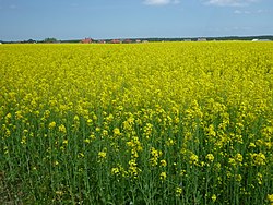 Yellow Fields of Kokoszkowy | |
 Kokoszkowy | |
| Coordinates: 53°59′50″N 18°31′41″E / 53.99722°N 18.52806°E | |
| Country | |
| Voivodeship | Pomeranian |
| County | Starogard |
| Gmina | Gmina Starogard Gdański |
| Population | 1,430 |
| Time zone | UTC+1 (CET) |
| • Summer (DST) | UTC+2 (CEST) |


Kokoszkowy [kɔkɔʂˈkɔvɨ] (German: Kokoschken) is a village in the administrative district of Gmina Starogard Gdański, within Starogard County, Pomeranian Voivodeship, in northern Poland.[1] It lies approximately 4 kilometres (2 mi) north of Starogard Gdański and 42 km (26 mi) south of the regional capital Gdańsk. It is located within the ethnocultural region of Kociewie in the historic region of Pomerania. It is famous for its church and it sits on the bus route between Starogard Gdański and Gdańsk.[2][3]
The village has a population of 1,430.
History[]
Kokoszkowy was a royal village of the Polish Crown, administratively located in the Tczew County in the Pomeranian Voivodeship.[4]
During the German invasion of Poland, which started World War II, on September 13, 1939, the Selbstschutz carried out a massacre of 10 Poles in the forest between Kokoszkowy and Szpęgawsk.[5] Teachers from Kokoszkowy were among Polish teachers murdered by the Germans on October 20, 1939 in the Szpęgawski Forest as part of the Intelligenzaktion.[6]
Village church of St. Barbara[]

The village is home to the church of St. Barbara (Kościół Świętej Barbary). This church dates back to the 14th century. Though mainly built of boulders, ist windows and its eastern gable make it an example of Brick Gothic style. There is a graveyard and a house behind the church aptly named after Pope John Paul II.
This church of the 14th century Knights Hospitaller was restored between 1995 and 2013 by the local parish priest Fr. Mark Błażejczyk, with the participation of numerous people of good will. In the church there are:
- – 1.Baroque altar from the early 18th century, carved, polychrome.
- – 2.Rococo side altars from the second half of the 18th century.
- – 3.Wooden carved 18th century baroque crucifix.
- – 4.Wooden baptismal font from the 18th century.
- – 5.Two feretones from the nineteenth century.
- – 6.Baroque altar “Crucifixion” in rococo, gilded frame Brass papal altar crucifix with inscription and date 1770
- – 7. There are 2 bells on the church tower: “Barbara” – 265 kg from 1952 and “Nicholas”.
In spring time, the fields around the village are a bright yellow as the region is known for growing the rapeseed oil plants.
References[]
- ^ "Central Statistical Office (GUS) - TERYT (National Register of Territorial Land Apportionment Journal)" (in Polish). 2008-06-01.
- ^ Blair, Jonny. "Kociewie Village Charm in Poland: Kokoszkowy, Rywałd and Gręblin". Culture Trip. Retrieved 2018-02-08.
- ^ Blair, Jonny. "Backpacking in Kokoszkowy". Northern Irishman in Poland. Retrieved 2018-02-08.
- ^ Marian Biskup, Andrzej Tomczak, Mapy województwa pomorskiego w drugiej połowie XVI w., Toruń, 1955, p. 110, 112 (in Polish)
- ^ Maria Wardzyńska, Był rok 1939. Operacja niemieckiej policji bezpieczeństwa w Polsce. Intelligenzaktion, IPN, Warszawa, 2009, p. 108 (in Polish)
- ^ Wardzyńska, p. 148-149

| show Authority control |
|---|
Coordinates: 53°59′50″N 18°31′41″E / 53.99722°N 18.52806°E
This Starogard County location article is a stub. You can help Wikipedia by . |
- Villages in Starogard County
- Starogard County geography stubs