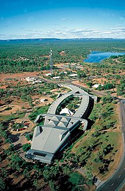
Jabiru, Northern Territory
| Jabiru Northern Territory | |||||||||
|---|---|---|---|---|---|---|---|---|---|
 Jabiru | |||||||||
| Coordinates | 12°40′S 132°50′E / 12.667°S 132.833°ECoordinates: 12°40′S 132°50′E / 12.667°S 132.833°E | ||||||||
| Population | 1,081 (2016 census)[1] | ||||||||
| Postcode(s) | 0886 | ||||||||
| Elevation | 27 m (89 ft) | ||||||||
| Location | 256 km (159 mi) from Darwin | ||||||||
| LGA(s) | West Arnhem Region | ||||||||
| Territory electorate(s) | Arafura | ||||||||
| Federal Division(s) | Lingiari | ||||||||
| |||||||||

Jabiru is a town in the Northern Territory of Australia. Built in 1982, the town is completely surrounded by Kakadu National Park. At the 2016 census, Jabiru had a population of 1,081.
History and governance[]
The town was originally built in 1982 as a closed town to house the community living at Jabiru East near the Ranger Uranium Mine 8 km (5.0 mi) away.[citation needed]
Jabiru Township is 13 square kilometres (5.0 sq mi) in size. The town is owned as freehold by the Director of National Parks, from which a head lease is held by the Jabiru Town Development Authority (JTDA). The JTDA subleases to the mining company, government agencies and private business. The head lease expires in 2021.[citation needed]
The JTDA delegated local government responsibility to the Jabiru Town Council. The Northern Territory Government amalgamated Jabiru Town Council and the West Arnhem Shire (Region) in 2008.[citation needed]
Jabiru town services are administered by the West Arnhem Regional Council, whose council chambers are in the town plaza.[verification needed]
The Mirrar clan were recognised as the traditional title holders of Jabiru Township in November 2018,[2] but a dispute over the native title was drawn out for years. The town was formally handed over to the Mirrar people on 16 June 2021 by the federal Minister for the Environment, Sussan Ley, and the Minister for Indigenous Australians, Ken Wyatt, with settlement date fixed at 30 June.[3]
Population[]
According to the 2016 census of Population, there were 1,081 people in Jabiru.[citation needed]
- Aboriginal and Torres Strait Islander people made up 24.3% of the population.
- 68.6% of people were born in Australia.
- 64.9% of people only spoke English at home.
- The most common response for religion was No Religion, at 36.8%.[1]
Description and facilities[]
Apart from the Ranger mine, Jabiru's most notable industries are tourism, being the commercial and accommodation hub of Kakadu National Park, and Aboriginal arts and culture. Jabiru features a small town plaza that includes government offices, magistrate's court and emergency services.[citation needed]
Recreational facilities include the Jabiru town lake (picnic areas and barbecues), freshwater fishing for barramundi (a local specialty), the Yellow Water cruise, day-trips to Ubirr Rock, Twin Falls and other natural features of Kakadu National Park.[citation needed]
There is a sports and social club, an Olympic-size swimming pool (the only place guaranteed safe from crocodiles to swim), cricket ovals where cricket and Australian rules football are played. Magela Field in Jabiru is home to the Jabiru Bushratz RUFC, who celebrate their 25th year in 2008. There is also a 9-hole golf course which is the only licensed premises for takeaway alcohol; however only members can buy takeaway alcohol there. Visitors can consume alcohol in opened containers on licensed premises.[citation needed]
West Arnhem Regional Council, with the support of Library & Archives NT, delivers public library and information services in Jabiru which are free to all residents of the region, with options also being available to short-term residents and visitors.[4] The library aims to provide a culture-rich environment with a focus on collecting materials, in all formats, with a focus on the Kakadu and West Arnhem region.[5]
Climate[]
Jabiru has a tropical savanna climate (Aw), typical of most of the Top End. Jabiru experiences heavy rain that often results in widespread flooding along the Arnhem Highway and Kakadu Highway. During 2006–07 Jabiru had its biggest wet season on record cutting both highways after almost 2 metres (6 ft 7 in) of rain fell over a 3-month period. The Arnhem Highway was cut off for several weeks as the West Alligator bridge was severely damaged. Temperatures can drop below 10 °C (50 °F) in the winter/dry season from May to August and peak at over 40 °C (104 °F) during the buildup season from September to November. Spectacular electrical storms are also frequent during this period, before the prolonged rains of the wet season arrive. The wet season is usually associated with the monsoon rains and tropical cyclones and it occurs between December and March (the southern hemisphere summer), when thunderstorms are common and afternoon relative humidity averages over 70 percent during the wettest months.
| hideClimate data for Jabiru | |||||||||||||
|---|---|---|---|---|---|---|---|---|---|---|---|---|---|
| Month | Jan | Feb | Mar | Apr | May | Jun | Jul | Aug | Sep | Oct | Nov | Dec | Year |
| Record high °C (°F) | 38.4 (101.1) |
37.7 (99.9) |
38.0 (100.4) |
38.0 (100.4) |
37.6 (99.7) |
36.7 (98.1) |
36.2 (97.2) |
38.1 (100.6) |
40.0 (104.0) |
42.3 (108.1) |
42.4 (108.3) |
41.6 (106.9) |
42.4 (108.3) |
| Average high °C (°F) | 33.7 (92.7) |
33.3 (91.9) |
33.8 (92.8) |
34.6 (94.3) |
33.5 (92.3) |
31.8 (89.2) |
32.1 (89.8) |
33.8 (92.8) |
36.3 (97.3) |
37.7 (99.9) |
37.0 (98.6) |
35.2 (95.4) |
34.4 (93.9) |
| Average low °C (°F) | 24.7 (76.5) |
24.5 (76.1) |
24.4 (75.9) |
23.6 (74.5) |
22.0 (71.6) |
19.5 (67.1) |
18.7 (65.7) |
19.2 (66.6) |
21.6 (70.9) |
23.9 (75.0) |
25.0 (77.0) |
25.0 (77.0) |
22.7 (72.9) |
| Record low °C (°F) | 20.3 (68.5) |
20.6 (69.1) |
19.5 (67.1) |
16.0 (60.8) |
13.9 (57.0) |
9.9 (49.8) |
8.8 (47.8) |
12.0 (53.6) |
12.0 (53.6) |
13.7 (56.7) |
19.0 (66.2) |
21.1 (70.0) |
8.8 (47.8) |
| Average rainfall mm (inches) | 361.0 (14.21) |
355.5 (14.00) |
304.9 (12.00) |
90.5 (3.56) |
16.8 (0.66) |
1.0 (0.04) |
3.0 (0.12) |
2.5 (0.10) |
11.7 (0.46) |
40.1 (1.58) |
137.0 (5.39) |
222.9 (8.78) |
1,546.9 (60.9) |
| Average rainy days | 21.8 | 20.6 | 19.9 | 7.9 | 2.4 | 0.3 | 0.3 | 0.3 | 0.9 | 3.7 | 11.1 | 16.7 | 105.9 |
| Average relative humidity (%) | 73.5 | 75.5 | 69.5 | 57.0 | 49.5 | 45.5 | 43.0 | 40.5 | 42.0 | 45.0 | 54.0 | 64.5 | 55.0 |
| Mean daily sunshine hours | 6.4 | 6.6 | 6.1 | 8.6 | 9.3 | 9.4 | 9.7 | 10.0 | 9.4 | 9.4 | 8.4 | 7.3 | 8.4 |
| Source: Bureau of Meteorology[6] | |||||||||||||
References[]
- ^ Jump up to: a b Australian Bureau of Statistics (27 June 2017). "Jabiru (State Suburb)". 2016 Census QuickStats. Retrieved 20 July 2017.

- ^ Damjanovic, Dijana (8 November 2018). "Jabiru native title claim victory for Mirarr traditional owners". Australian Broadcasting Corporation. Retrieved 9 November 2018.
- ^ "Jabiru handed to Indigenous owners the Mirarr people after long-running native title dispute". The Guardian. 26 June 2021. Retrieved 28 June 2021.
- ^ Government, Northern Territory (23 February 2021). "Find a library in the NT". nt.gov.au. Retrieved 24 May 2021.
- ^ "Library Services & Languages | West Arnhem Regional Council". westarnhem.nt.gov.au. Retrieved 24 May 2021.
- ^ "Climate statistics for Australian locations – Jabiru Airport". 19 April 2021.
- Towns in the Northern Territory
- Mining towns in the Northern Territory
- Kakadu National Park