Jamo, Uttar Pradesh
Jamo
Jāmun, Jamon | |
|---|---|
Village | |
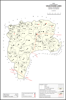 Map showing Jamo (#060) in Jamo CD block | |
 Jamo Location in Uttar Pradesh, India | |
| Coordinates: 26°22′08″N 81°39′50″E / 26.368758°N 81.664°ECoordinates: 26°22′08″N 81°39′50″E / 26.368758°N 81.664°E[1] | |
| Country | |
| State | Uttar Pradesh |
| Division | Faizabad division |
| District | Amethi |
| Area | |
| • Total | 6.088 km2 (2.351 sq mi) |
| Population (2011)[2] | |
| • Total | 6,734 |
| • Density | 1,100/km2 (2,900/sq mi) |
| Languages | |
| • Official | Hindi, Urdu |
| Time zone | UTC+5:30 (IST) |
Jamo, also spelled Jamun or Jamon, is a village and community development block headquarters in Gauriganj tehsil of Amethi district, Uttar Pradesh, India.[2] As of 2011, it has a population of 6,734 people, in 1,182 households.[2] It was historically the capital of the pargana of .[3] It is located at the intersection of four minor district roads, some of which are prone to flooding during the rainy season.[3]
History[]
Jamo was historically the capital of the pargana called .[3] It was also the seat of a taluqdari estate held by a branch of the Kanhpuria Rajputs.[3] The Jamo branch originated in a partition of lands among the four sons of one Balbhaddar Singh; the other three branches were Katari, , and .[3] The Baraulia taluqa was later formed as a junior branch of the Jamo taluqa.[3]
At the turn of the 20th century, Jamo was described as consisting of a built-up block surrounded by a moat and 21 dependant hamlets.[3] It had an aided school, maintained by the taluqdar and with only a few students.[3] It had a village bank.[3] The population as of 1901 was 1,967 people, and the majority of them were Brahmins, including the leading family of some prosperous moneylenders who owned several large houses in town.[3] The village was described as good for agriculture with many shallow depressions providing plenty of water for irrigation.[3] At that time, the Jamo taluqdar Mahabir Bakhsh Singh held 17 villages, all in the pargana of Gaura Jamun, but he was severely in debt and the estate was in effect mortgaged to a nobleman from Rewah State.[3]
The 1951 census recorded Jamo as comprising 20 hamlets, with a total population of 2,170 people (1,065 male and 1,105 female), in 468 households and 447 physical houses.[4] The area of the village was given as 1,525 acres.[4] 70 residents were literate, all male.[4] The village was listed as belonging to the pargana of Gaura Jamo and the thana of Jagdishpur.[4] The village had a district board-run primary school with 124 students in attendance as of 1 January 1951.[4]
The 1961 census recorded Jamo (as "Jamon") as comprising 20 hamlets, with a total population of 2,075 people (1,041 male and 1,034 female), in 508 households and 454 physical houses..[5] The area of the village was given as 1,525 acres and it had a post office at that point, as well as a government-run dispensary with 2 male and 2 female beds.[5] The Uma Raman Higher Secondary School, established in August 1950, had a staff of 15 teachers (all male) and an attendance of 463 students (all male) that year.[5]
The 1981 census recorded Jamo as having a population of 3,261 people, in 679 households, and having an area of 617.17 hectares.[6] The main staple foods were listed as wheat and rice.[6]
The 1991 census recorded Jamo as having a total population of 3,514 people (1,938 male and 1,576 female), in 731 households and 719 physical houses.[7] The area of the village was listed as 617.00 hectares.[7] Members of the 0-6 age group numbered 579, or 16.5% of the total; this group was 51% male (297) and 49% female (282).[7] Members of scheduled castes numbered 1,062, or 30% of the village's total population, while no members of scheduled tribes were recorded.[7] The literacy rate of the village was 32.5% (755 men and 200 women, counting only people age 7 and up).[7] 1,231 people were classified as main workers (1,098 men and 133 women), while 3 people were classified as marginal workers (all women); the remaining 2,280 residents were non-workers.[7] The breakdown of main workers by employment category was as follows: 612 cultivators (i.e. people who owned or leased their own land); 283 agricultural labourers (i.e. people who worked someone else's land in return for payment); 4 workers in livestock, forestry, fishing, hunting, plantations, orchards, etc.; 0 in mining and quarrying; 61 household industry workers; 41 workers employed in other manufacturing, processing, service, and repair roles; 14 construction workers; 73 employed in trade and commerce; 8 employed in transport, storage, and communications; and 135 in other services.[7]
Villages[]
Jamo CD block has the following 91 villages:[2]
| Village name | Total land area (hectares) | Population (in 2011) |
|---|---|---|
| 163.8 | 1,817 | |
| 45.3 | 1,126 | |
| 102.3 | 572 | |
| 41.8 | 401 | |
| 89.4 | 401 | |
| 177.8 | 1,864 | |
| 97.6 | 243 | |
| 80.2 | 566 | |
| 59.6 | 562 | |
| Dakhinwara | 380.4 | 3,840 |
| 151 | 1,338 | |
| 47.9 | 759 | |
| 36.4 | 296 | |
| 255.4 | 2,521 | |
| 211 | 1,207 | |
| 33.1 | 693 | |
| 138.8 | 1,279 | |
| 92.4 | 821 | |
| 158.1 | 1,071 | |
| 130 | 1,204 | |
| 193.4 | 821 | |
| 449.1 | 4,342 | |
| 64.1 | 480 | |
| 270.3 | 2,124 | |
| 441 | 4,190 | |
| 243.8 | 2,513 | |
| Gaura | 488.7 | 4,349 |
| 192.2 | 1,503 | |
| 251.5 | 2,048 | |
| Katari | 711.5 | 6,500 |
| 479.2 | 1,275 | |
| 251.1 | 2,143 | |
| 592.6 | 5,476 | |
| 134.6 | 1,192 | |
| Jamo (block headquarters) | 608.8 | 6,734 |
| 126.5 | 1,453 | |
| 165.1 | 915 | |
| 504.6 | 4,554 | |
| 192.8 | 1,725 | |
| 138.8 | 1,332 | |
| 1,023.6 | 6,140 | |
| 194.7 | 1,367 | |
| 150.4 | 1,227 | |
| 442.7 | 3,019 | |
| 501.5 | 3,397 | |
| 79.3 | 663 | |
| 162.3 | 1,496 | |
| Bakhshgarh | 361.1 | 1,628 |
| 301.9 | 1,778 | |
| 240.4 | 1,945 | |
| 320.8 | 1,561 | |
| 392.8 | 1,529 | |
| 228.1 | 936 | |
| 853.2 | 5,814 | |
| 25.8 | 286 | |
| 393.7 | 1,689 | |
| 253 | 1,960 | |
| 19.6 | 47 | |
| 111.3 | 711 | |
| 404.3 | 2,046 | |
| 175 | 1,274 | |
| 265.5 | 1,496 | |
| Barauliya | 611.2 | 3,878 |
| 192.8 | 852 | |
| 358.4 | 2,395 | |
| 452 | 2,215 | |
| 67.4 | 272 | |
| 144.6 | 741 | |
| 277 | 0 | |
| 144.7 | 572 | |
| 930.1 | 7,690 | |
| 38.8 | 573 | |
| 252.8 | 2,148 | |
| 488 | 3,396 | |
| 62.1 | 543 | |
| 93.7 | 1,249 | |
| 200.6 | 1,353 | |
| 116.2 | 995 | |
| 458.4 | 3,795 | |
| 245.8 | 1,694 | |
| 309.4 | 1,685 | |
| 166.2 | 1,244 | |
| 150.2 | 1,044 | |
| 281.5 | 2,207 | |
| 486.5 | 2,549 | |
| 190.1 | 1,220 | |
| 145.9 | 1,058 | |
| 195.5 | 1,382 | |
| 291.9 | 1,564 | |
| Block total | 23,577.1 | 171,303 |
| Village name | Total land area (hectares) | Population (in 2011) |
References[]
- ^ "Geonames Search". Do a radial search using these coordinates here.
- ^ a b c d e "Census of India 2011: Uttar Pradesh District Census Handbook - Sultanpur, Part A (Village and Town Directory)" (PDF). Census 2011 India. pp. 147–63. Retrieved 17 December 2021.
- ^ a b c d e f g h i j k l Nevill, H.R. (1903). Sultanpur: A Gazetteer, Being Volume XLVI Of The District Gazetteers Of The United Provinces Of Agra And Oudh. Allahabad: Government Press. pp. 99–100, 177, 186–7. Retrieved 17 December 2021.
- ^ a b c d e Census of India, 1951: District Census Handbook Uttar Pradesh (49 - Rae Bareli District) (PDF). Allahabad. 1955. pp. 130–1, 199. Retrieved 17 December 2021.
- ^ a b c Census 1961: District Census Handbook, Uttar Pradesh (44 - Sultanpur District) (PDF). Lucknow. 1965. pp. 121, 124, xviii–xix. Retrieved 17 December 2021.
- ^ a b Census 1981 Uttar Pradesh: District Census Handbook Part XIII-A: Village & Town Directory, District Rae Bareli (PDF). 1982. pp. 48–9. Retrieved 17 December 2021.
- ^ a b c d e f g Census 1991 Series-25 Uttar Pradesh Part-XII B Village & Townwise Primary Census Abstract District Census Handbook District Raebareli (PDF). 1992. pp. xxiv–xxviii, 86–7. Retrieved 17 December 2021.
This Amethi district location article is a stub. You can help Wikipedia by . |
- Villages in Amethi district
- Community development blocks in India
- Former zamindari estates in Uttar Pradesh
- Faizabad division geography stubs