Jasper Avenue
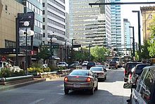
 Jasper Avenue west from 103 Street. | |||
 class=notpageimage| Start/End points of Jasper Avenue | |||
| Namesake | Jasper Hawes / Jasper, Alberta | ||
|---|---|---|---|
| Maintained by | City of Edmonton | ||
| Length | 6.2 km[1] (3.9 mi) | ||
| Location | Edmonton | ||
| West end | 125 Street | ||
| Major junctions | 124 Street, 109 Street, 105 Street, 101 Street, 97 Street, 103A Avenue, 82 Street | ||
| East end | 77 Street | ||
Jasper Avenue is an arterial road in central Edmonton, Alberta, and is the city's main street. Jasper Avenue has no official street number but is aligned with 101 Avenue with the majority of its length. Jasper Avenue is a major public transit route as several of Edmonton's busiest bus routes travel along it. The LRT travels underneath Jasper Avenue between 99 and 110 Streets. It is named after Jasper Hawes, manager of a North West Company trading post of Jasper House in the early 1800s, located in present-day Jasper National Park.[2]
Route description[]
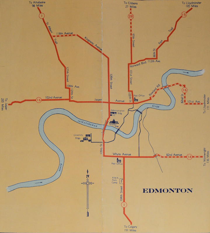
Jasper Avenue begins at 125 Street in the community of Westmount as a local residential street. One block to the east, 124 Street turns east and becomes Jasper Avenue, which functions as its unofficial western terminus, with 102 Avenue taking over as the main east-west artery to west Edmonton. Jasper Avenue passes the community of Oliver through mixed retail and high density residential. East of 109 Street, Jasper Avenue passes through the downtown core and is home to many of Edmonton's oldest heritage buildings (for example the Hotel Macdonald) and some of Edmonton's tallest office towers, including Canadian Western Bank Place and Scotia Place. East of 97 Street, Jasper Avenue departs from both the downtown core and the 101 Avenue alignment, running northeast along the North Saskatchewan River valley through the community of Boyle Street. At 82 Street, the roadway turns north; however Jasper Avenue continues east as a local residential street through the community of Cromdale, ending at 77 Street.[1] The Jasper West area (west of 97 Street) is one of the major retail, living, commercial, and entertainment districts of the city.
History[]

While slow reinvestment continued into the 2000s, the downtown core has recently seen increased development, such as the rise of the Warehouse District and Ice District to the north, resulting in increased activity and redevelopment along Jasper Avenue.[2][3]
The original alignment of Highway 16 which entered Edmonton from the west along Stony Plain Road and 102 Avenue, followed Jasper Avenue between 124 Street and 95 Street, where it connected with Rowland Road and the Dawson Bridge, left Edmonton to the east along 101 Avenue.[4] In the 1950s, Highway 16 was moved to 111 Avenue and 118 Avenue, resulting in the inner city route becoming Highway 16A.[5] In the early 1980s, the Highway 16A designation along Jasper Avenue was phased out.

Neighbourhoods[]
List of neighbourhoods Jasper Avenue runs through, in order from west to east:[6]
Major intersections[]
Starting at the west end of Jasper Avenue. The entire route is in Edmonton.
| km[1] | mi | Destinations | Notes | ||
|---|---|---|---|---|---|
| 0.0 | 0.0 | 125 Street | At-grade | ||
| 0.1 | 0.062 | Roadway turns east; eastbound right-in/right-out | |||
| Through traffic follows 124 Street | |||||
| 0.5 | 0.31 | 121 Street | At-grade (traffic lights) | ||
| 1.1 | 0.68 | 116 Street | At-grade (traffic lights) | ||
| 1.6 | 0.99 | 112 Street – Edmonton General Hospital | At-grade (traffic lights) | ||
| 2.0 | 1.2 | At-grade (traffic lights) | |||
| 2.1 | 1.3 | 108 Street (Capital Boulevard) | At-grade (traffic lights) | ||
| 2.2 | 1.4 | 107 Street – Alberta Legislature Building | At-grade (traffic lights) | ||
| Passes over | |||||
| 2.3 | 1.4 | 106 Street | At-grade (traffic lights) | ||
| 2.4 | 1.5 | 105 Street | At-grade (traffic lights) | ||
| 2.6 | 1.6 | 104 Street | At-grade (traffic lights) | ||
| 2.6– 2.7 | 1.6– 1.7 | Passes over | |||
| 2.7 | 1.7 | 103 Street | At-grade (traffic lights) | ||
| 2.8 | 1.7 | 102 Street | At-grade (traffic lights) | ||
| 2.9 | 1.8 | 101 Street | At-grade (traffic lights) | ||
| 3.0 | 1.9 | Rice Howard Way (100A Street) | At-grade (traffic lights); no vehicle access from Jasper Avenue | ||
| 3.0– 3.2 | 1.9– 2.0 | Passes over | |||
| 3.2 | 2.0 | 100 Street – Hotel Macdonald | At-grade (traffic lights) | ||
| 3.3 | 2.1 | 99 Street – Churchill Square, City Hall, Royal Alberta Museum | At-grade (traffic lights) | ||
| 3.5 | 2.2 | At-grade (traffic lights) | |||
| 4.1 | 2.5 | 95 Street (to Rowland Road) | At-grade (traffic lights) | ||
| 102 Avenue | No access from Jasper Ave (one-way eastbound) | ||||
| 4.5 | 2.8 | 103A Avenue / 92 Street | At-grade (traffic lights) | ||
| 5.6 | 3.5 | Roadway turns north; westbound right-in/right-out | |||
| Through traffic follows 82 Street | |||||
| 6.2 | 3.9 | 77 Street | At-grade | ||
1.000 mi = 1.609 km; 1.000 km = 0.621 mi
| |||||
See also[]
Route map:

| ( • help)
|
| Wikimedia Commons has media related to Jasper Avenue, Edmonton. |
References[]
- ^ a b c Google (November 9, 2017). "Jasper Avenue in Edmonton, AB" (Map). Google Maps. Google. Retrieved November 9, 2017.
- ^ a b vbinnema (April 10, 2013). "Jasper Avenue". Your Edmonton Guru. Wordpress. Retrieved November 10, 2017.
- ^ "2.1: Historic Overview of Jasper Avenue". Towards a New Vision for Jasper Avenue (PDF) (Report). City of Edmonton. February 2011. p. 14. Retrieved November 12, 2017.
- ^ Alberta Official Road Map (Map). Department of Public Works. 1940. Edmonton inset.
- ^ The H.M. Gousha Company (1956). Shell Map of British Columbia, Alberta, Saskatchewan, and Manitoba (Map). The Shell Oil Company. Edmonton inset.
- ^ City of Edmonton map utility
External links[]
- Experience Jasper Avenue - City of Edmonton - redesign Jasper Avenue between 109 Street and 124 Street
Attractions and landmarks in Edmonton | ||
|---|---|---|
| Landmarks |  | |
| Attractions | ||
| Venues |
| |
| Parks | ||
| Shopping centres |
| |
| Shopping/ entertainment districts | ||
- Roads in Edmonton