Junction Boulevard station
Junction Blvd | ||||||||||||||||||||||||||||||||||||||||||||||||||||||||||||||||||||||||||||||||||||||||||||||||
|---|---|---|---|---|---|---|---|---|---|---|---|---|---|---|---|---|---|---|---|---|---|---|---|---|---|---|---|---|---|---|---|---|---|---|---|---|---|---|---|---|---|---|---|---|---|---|---|---|---|---|---|---|---|---|---|---|---|---|---|---|---|---|---|---|---|---|---|---|---|---|---|---|---|---|---|---|---|---|---|---|---|---|---|---|---|---|---|---|---|---|---|---|---|---|---|---|
 | ||||||||||||||||||||||||||||||||||||||||||||||||||||||||||||||||||||||||||||||||||||||||||||||||
| Station statistics | ||||||||||||||||||||||||||||||||||||||||||||||||||||||||||||||||||||||||||||||||||||||||||||||||
| Address | Junction Boulevard & Roosevelt Avenue Queens, NY 11368 | |||||||||||||||||||||||||||||||||||||||||||||||||||||||||||||||||||||||||||||||||||||||||||||||
| Borough | Queens | |||||||||||||||||||||||||||||||||||||||||||||||||||||||||||||||||||||||||||||||||||||||||||||||
| Locale | Corona | |||||||||||||||||||||||||||||||||||||||||||||||||||||||||||||||||||||||||||||||||||||||||||||||
| Coordinates | 40°44′57.03″N 73°52′8.75″W / 40.7491750°N 73.8690972°WCoordinates: 40°44′57.03″N 73°52′8.75″W / 40.7491750°N 73.8690972°W | |||||||||||||||||||||||||||||||||||||||||||||||||||||||||||||||||||||||||||||||||||||||||||||||
| Division | A (IRT)[1] | |||||||||||||||||||||||||||||||||||||||||||||||||||||||||||||||||||||||||||||||||||||||||||||||
| Line | IRT Flushing Line | |||||||||||||||||||||||||||||||||||||||||||||||||||||||||||||||||||||||||||||||||||||||||||||||
| Services | 7 | |||||||||||||||||||||||||||||||||||||||||||||||||||||||||||||||||||||||||||||||||||||||||||||||
| Transit | ||||||||||||||||||||||||||||||||||||||||||||||||||||||||||||||||||||||||||||||||||||||||||||||||
| Structure | Elevated | |||||||||||||||||||||||||||||||||||||||||||||||||||||||||||||||||||||||||||||||||||||||||||||||
| Platforms | 2 island platforms cross-platform interchange | |||||||||||||||||||||||||||||||||||||||||||||||||||||||||||||||||||||||||||||||||||||||||||||||
| Tracks | 3 | |||||||||||||||||||||||||||||||||||||||||||||||||||||||||||||||||||||||||||||||||||||||||||||||
| Other information | ||||||||||||||||||||||||||||||||||||||||||||||||||||||||||||||||||||||||||||||||||||||||||||||||
| Opened | April 21, 1917 | |||||||||||||||||||||||||||||||||||||||||||||||||||||||||||||||||||||||||||||||||||||||||||||||
| Station code | 451[2] | |||||||||||||||||||||||||||||||||||||||||||||||||||||||||||||||||||||||||||||||||||||||||||||||
| Accessible | ||||||||||||||||||||||||||||||||||||||||||||||||||||||||||||||||||||||||||||||||||||||||||||||||
| Opposite- direction transfer | Yes | |||||||||||||||||||||||||||||||||||||||||||||||||||||||||||||||||||||||||||||||||||||||||||||||
| Former/other names | Junction Avenue (1917-1940) | |||||||||||||||||||||||||||||||||||||||||||||||||||||||||||||||||||||||||||||||||||||||||||||||
| Traffic | ||||||||||||||||||||||||||||||||||||||||||||||||||||||||||||||||||||||||||||||||||||||||||||||||
| 2019 | 6,883,317[4] | |||||||||||||||||||||||||||||||||||||||||||||||||||||||||||||||||||||||||||||||||||||||||||||||
| Rank | 58 out of 424[4] | |||||||||||||||||||||||||||||||||||||||||||||||||||||||||||||||||||||||||||||||||||||||||||||||
| Station succession | ||||||||||||||||||||||||||||||||||||||||||||||||||||||||||||||||||||||||||||||||||||||||||||||||
| Next north | Mets–Willets Point (express): <7> 103rd Street–Corona Plaza (local): 7 | |||||||||||||||||||||||||||||||||||||||||||||||||||||||||||||||||||||||||||||||||||||||||||||||
| Next south | 90th Street–Elmhurst Avenue (local): 7 61st Street–Woodside (express): <7> | |||||||||||||||||||||||||||||||||||||||||||||||||||||||||||||||||||||||||||||||||||||||||||||||
| ||||||||||||||||||||||||||||||||||||||||||||||||||||||||||||||||||||||||||||||||||||||||||||||||
| ||||||||||||||||||||||||||||||||||||||||||||||||||||||||||||||||||||||||||||||||||||||||||||||||
| ||||||||||||||||||||||||||||||||||||||||||||||||||||||||||||||||||||||||||||||||||||||||||||||||
| ||||||||||||||||||||||||||||||||||||||||||||||||||||||||||||||||||||||||||||||||||||||||||||||||


The Junction Boulevard station (originally Junction Avenue station)[5] is an express station on the IRT Flushing Line of the New York City Subway, located at the intersection of Junction Boulevard and Roosevelt Avenue in Corona, Queens.[6] It is served by the 7 train at all times and by rush hour peak-direction <7> express service.[7]
History[]
This elevated station opened on April 21, 1917 as Junction Avenue, as part of a large extension of the Flushing Line from its previous eastern terminus at Queensboro Plaza to Alburtis Avenue (now 103rd Street–Corona Plaza). It was part of the Brooklyn–Manhattan Transit Corporation, albeit served by shuttles of IRT dimensions, and the two companies jointly operated the Flushing and Astoria Lines due to the provisions of the Dual Contracts. The station was renamed Junction Boulevard in 1940.[8]
The platforms at Junction Boulevard were extended in 1955–1956 to accommodate 11-car trains.[9]
In 1981, the Metropolitan Transportation Authority listed the station among the 69 most deteriorated stations in the subway system.[10]
Station layout[]
| 3F | Crossover | Transfer between platforms |
| 2F Platform level |
Southbound local | ← |
| Island platform | ||
| Peak-direction express | ← | |
| Island platform | ||
| Northbound local | | |
| 1F | Mezzanine | Fare control, station agent, MetroCard machines |
| G | Street level | Entrances/exits |

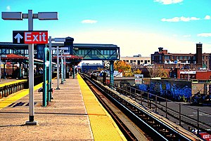
This station has two island platforms and three tracks.[11] The two outer local tracks are used by the full-time 7 local service while the middle express track is used by the rush-hour peak direction <7> express service.[7] Both platforms have red canopies with green frames and support columns in the center and are narrower at either ends.
Exits[]
This station has one elevated station house beneath the platforms tracks. Four staircases from each corner of Junction Boulevard and Roosevelt Avenue go up to a mezzanine that has a token booth in the center and a turnstile bank on the east and west sides.[12] These turnstile banks lead to a crossunder and has a single staircase going up to each platform towards the west (railroad south) end.
This station was made ADA accessible in 2007, at the cost of $6 million. From the northeast corner of the intersection this station is located at, a single elevator goes up to an enclosed overpass above the platforms with an intermediate stop at the mezzanine.[13] The overpass has two HEET turnstiles and a gate that is automatically opened when a MetroCard is swiped at either turnstile. Inside, two elevators go down to the platforms, one for each. Previously, an "AutoGate" Reduced-fare MetroCard was required to open the gate.[14][15] An emergency staircase goes down to the Manhattan-bound platform and an employee-facility is on the Flushing-bound end of the overpass.
References[]
- ^ "Glossary". Second Avenue Subway Supplemental Draft Environmental Impact Statement (SDEIS) (PDF). Vol. 1. Metropolitan Transportation Authority. March 4, 2003. pp. 1–2. Archived from the original (PDF) on February 26, 2021. Retrieved January 1, 2021.
- ^ "Station Developers' Information". Metropolitan Transportation Authority. Retrieved June 13, 2017.
- ^ "Facts and Figures: Annual Subway Ridership 2014–2019". Metropolitan Transportation Authority. 2020. Retrieved May 26, 2020.
- ^ a b "Facts and Figures: Annual Subway Ridership 2014–2019". Metropolitan Transportation Authority. 2020. Retrieved May 26, 2020.
- ^ "STATION SITES FOR NEW SUBWAYS; Pamphlet Issued by Utilities Board Contains List of Stops on Dual System" (PDF). The New York Times. July 6, 1913. Retrieved September 24, 2015.
- ^ "MTA Neighborhood Maps: Corona" (PDF). Metropolitan Transportation Authority. 2015. Retrieved September 20, 2015.
- ^ a b "7 Subway Timetable, Effective September 13, 2020". Metropolitan Transportation Authority. Retrieved December 9, 2020.
- ^ "1940 BMT system map" (PDF). NYCSubway. Retrieved June 12, 2011.
- ^ Authority, New York City Transit (1955). Minutes and Proceedings.
- ^ Gargan, Edward A. (June 11, 1981). "Agency Lists Its 69 Most Deteriorated Subway Stations". The New York Times. Retrieved August 13, 2016.
- ^ Dougherty, Peter (2006) [2002]. Tracks of the New York City Subway 2006 (3rd ed.). Dougherty. OCLC 49777633 – via Google Books.
- ^ "MTA Neighborhood Maps: Corona" (PDF). Metropolitan Transportation Authority. 2015. Retrieved September 20, 2015.
- ^ s.r.o., Minion Interactive. "Junction Blvd Station - Projects | Mega Contracting Group, LLC". www.megagroup.nyc. Retrieved October 6, 2016.
- ^ "NYC Official Accessibility Guide" (PDF). nyc.gov. City of New York. 2008. Archived from the original (PDF) on August 7, 2015. Retrieved September 20, 2015.
- ^ Zimmer, Amy (June 13, 2002). "Stuck in the System: Disabled rider questions subway access". disablednyc.com. City Hall: Metro New York. Retrieved September 20, 2015.
External links[]
| Wikimedia Commons has media related to Junction Boulevard (IRT Flushing Line). |
- nycsubway.org – IRT Flushing Line: Junction Boulevard
- Station Reporter — 7 Train
- The Subway Nut — Junction Boulevard Pictures
- Junction Boulevard entrance from Google Maps Street View
- Platforms from Google Maps Street View
| |
| |
| Flushing Line |
|
|---|---|
| |
- Accessible New York City Subway stations
- IRT Flushing Line stations
- New York City Subway stations in Queens, New York
- New York City Subway stations located aboveground
- Railway stations in the United States opened in 1917
- 1917 establishments in New York City
- Corona, Queens