Jackson Heights–Roosevelt Avenue/74th Street station
Jackson Heights– Roosevelt Avenue/74 Street | |||||||||||||
|---|---|---|---|---|---|---|---|---|---|---|---|---|---|
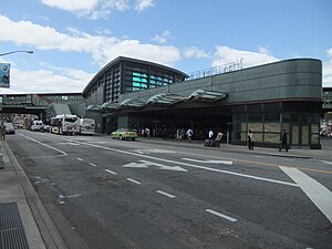 The station complex and adjoining bus terminal as seen from Broadway and 75th Street | |||||||||||||
| Station statistics | |||||||||||||
| Address | Roosevelt Avenue, 74th Street & Broadway Jackson Heights, NY 11372 | ||||||||||||
| Borough | Queens | ||||||||||||
| Locale | Jackson Heights | ||||||||||||
| Coordinates | 40°44′48″N 73°53′28″W / 40.74667°N 73.89111°WCoordinates: 40°44′48″N 73°53′28″W / 40.74667°N 73.89111°W | ||||||||||||
| Division | A (IRT), B (IND)[1] | ||||||||||||
| Line | IRT Flushing Line IND Queens Boulevard Line | ||||||||||||
| Services | 7 E F M R | ||||||||||||
| Transit | |||||||||||||
| Levels | 2 | ||||||||||||
| Other information | |||||||||||||
| Station code | 616[2] | ||||||||||||
| Accessible | |||||||||||||
| Traffic | |||||||||||||
| 2019 | 17,077,862[3] | ||||||||||||
| Rank | 14 out of 424[3] | ||||||||||||
| |||||||||||||
| |||||||||||||
| |||||||||||||


The Jackson Heights–Roosevelt Avenue/74th Street station (or simply Jackson Heights station or 74th Street–Roosevelt station) is a New York City Subway station complex served by the IRT Flushing Line and the IND Queens Boulevard Line. Located at the triangle of 74th Street, Broadway, and Roosevelt Avenue in Jackson Heights, Queens, it is served by the:
- 7, E, and F trains at all times
- R train at all times except late nights
- M train weekdays except late nights
- <F> train during rush hours in the peak direction
In 2019, it was the second-busiest subway station in Queens and the 14th busiest subway station in the system.[3]
History[]

The elevated IRT Flushing Line station opened on April 21, 1917, as part of an extension of the line from Queensboro Plaza to 103rd Street–Corona Plaza under the Dual Contracts.[4] The IND Queens Boulevard Line station opened on August 19, 1933, as part of the IND Queens Boulevard Line's initial segment, from the 50th Street station in Manhattan to Jackson Heights in Queens. Upon the opening of the Queens Boulevard Line station, a transfer between the two lines was implemented.[5][6][7] The station was the Queens Boulevard Line's terminus from 1933 until an extension east to Union Turnpike opened on December 31, 1936.[8][9][10] An uncompleted upper level station was also built along with the completed lower level station.[11][12][13] The construction of the new Roosevelt Avenue complex led to increased demand for housing in the area.[14] It also inspired plans for a proposed shopping mall nearby, which was ultimately not built.[15]
The Victor Moore Arcade,[16] a streamlined local landmark where passengers could transfer from the new IND subway to buses for distant neighborhoods and for LaGuardia Airport,[17] officially opened on December 11, 1941.[16] The two-story bus terminal and arcade, located at the triangle formed by Broadway, Roosevelt Avenue, and 75th Street,[16] also featured a shopping area.[16] The structure was named after Victor Moore, a notable Broadway actor and Freeport resident[16][18] who had appealed to build a bus terminal in his name along Broadway and near the station.[19] It served as a hub for the operations of Triboro Coach.[20][21]
On May 2, 1970, an out-of-service GG train collided with another GG train in revenue service on the Queens Boulevard Line. The revenue-service train was switching from the southbound express track to the local track (it had been rerouted around the out-of-service train). Two people died and 71 were injured in the worst subway collision since the 1928 Times Square derailment.[22][23][24] Following the 1970 accident, New York Magazine highlighted the state of the subway system in a lengthy exposé, in which it concluded that the subway's condition was getting worse compared to previous years.[22]
Construction on a new station building at that site began in 2001[25] and completed in 2005,[26] based on a design by Stantec.[27] During the renovation, the bus terminal was closed; the Flushing Line platforms and the bus terminal were completely rebuilt; and the Queens Boulevard Line platforms were refurbished[26] by construction firm Skanska[28] for a total cost of $132 million.[29]
Station layout[]
| 2F | Side platform | |
| Southbound local | ← | |
| Peak-direction express | ← | |
| Northbound local | → | |
| Side platform | ||
| 1F | Upper mezzanine | Connection between entrance/exit and elevated platforms |
| G | Street level | Exit/entrance, station house, fare control, bus loops |
| B1–2 | Lower mezzanines | Connection between entrance/exit and underground platforms |
| B3 | Southbound local | ← ← ← |
| Island platform | ||
| Southbound express | ← ← | |
| Northbound express | | |
| Island platform | ||
| Northbound local | | |

The station complex consists of two separate stations, connected by escalators, stairs, and elevators. The main entrance, a station building bounded by Roosevelt Avenue, 75th Street, Broadway, and 74th Street, includes the Victor A. Moore Bus Terminal.[25] The new station building is one of the first green buildings in the MTA system, which is partially powered by solar panels built into the roof.[26][27] The building is made of recycled material such as concrete consisted of 15% fly ash and steel that was prefabricated; in addition, the builders recycled 86% of the waste materials.[27] The station building also contains some retail space at the corner of 75th Street and Broadway, and also leases a few other spaces between the fare control area and the bus terminal.[29]
Two stairs and an elevator, from each of the Flushing Line platforms, lead down to an aboveground landing, whereupon a set of stairs leads to the main station house, which also contains the station agent booth.[30] The Flushing-bound platform's elevator leads from the Flushing-bound platform to the aboveground landing, then to the street level fare control, and finally to a landing between the street level and the belowground Queens Boulevard Line mezzanine.[31] The full-time station agent booth, and two banks of turnstiles for fare control, are located in this station house at street level.[30][31] Two escalators also lead directly from the Flushing Line landing to the Queens Boulevard Line mezzanine.[31] From the mezzanine, various stairs lead down to each of the Queens Boulevard Line platforms, and an elevator from the belowground landing leads to the mezzanine and the Manhattan-bound platform. There is another elevator from the Forest Hills- and Jamaica-bound platform to the mezzanine.[31] There are also some stores and an ATM lining the mezzanine within fare control.[31]
The 2004 artwork in the station house is called Passage by Tom Patti, and was designed in conjunction with FX+FOWLE Architects. The artwork consisted of trapezoid-shaped laminated glass panels located on the upper part of the building's eastern facade. The glass panels break up light into different colors, depending on the vantage point.[32][33]
Alternate exits[]
At 73rd Street and Broadway, on the north side of Roosevelt Avenue, a set of stairs from each of the IRT Flushing Line platforms lead down to a landing below the elevated structure.[31] There is a connection to the Queens Boulevard Line mezzanine via three long, narrow escalators, where there are exits from the below-ground fare control points.[30]
Exits from the underground mezzanine lead to the station building; the northeast corner of 73rd Street, 37th Road, and Broadway; the southwest corner of Broadway and 74th Street; and both eastern corners of Broadway and 75th Street.[34] The only direct exit from the Flushing Line platforms is from the 74th Street mezzanine, which leads to the station building, with an additional side exit to the northeast corner of Roosevelt Avenue and 74th Street.[30][34]
IRT Flushing Line platforms[]
74 Street–Broadway | ||||||||||||||||||||||||||||||||||||||||||||||||||||||||||||||||||||||||||||||||||||||||||||||||
|---|---|---|---|---|---|---|---|---|---|---|---|---|---|---|---|---|---|---|---|---|---|---|---|---|---|---|---|---|---|---|---|---|---|---|---|---|---|---|---|---|---|---|---|---|---|---|---|---|---|---|---|---|---|---|---|---|---|---|---|---|---|---|---|---|---|---|---|---|---|---|---|---|---|---|---|---|---|---|---|---|---|---|---|---|---|---|---|---|---|---|---|---|---|---|---|---|
 Manhattan bound platform | ||||||||||||||||||||||||||||||||||||||||||||||||||||||||||||||||||||||||||||||||||||||||||||||||
| Station statistics | ||||||||||||||||||||||||||||||||||||||||||||||||||||||||||||||||||||||||||||||||||||||||||||||||
| Division | A (IRT)[35] | |||||||||||||||||||||||||||||||||||||||||||||||||||||||||||||||||||||||||||||||||||||||||||||||
| Line | IRT Flushing Line | |||||||||||||||||||||||||||||||||||||||||||||||||||||||||||||||||||||||||||||||||||||||||||||||
| Services | 7 | |||||||||||||||||||||||||||||||||||||||||||||||||||||||||||||||||||||||||||||||||||||||||||||||
| Structure | Elevated | |||||||||||||||||||||||||||||||||||||||||||||||||||||||||||||||||||||||||||||||||||||||||||||||
| Platforms | 2 side platforms | |||||||||||||||||||||||||||||||||||||||||||||||||||||||||||||||||||||||||||||||||||||||||||||||
| Tracks | 3 | |||||||||||||||||||||||||||||||||||||||||||||||||||||||||||||||||||||||||||||||||||||||||||||||
| Other information | ||||||||||||||||||||||||||||||||||||||||||||||||||||||||||||||||||||||||||||||||||||||||||||||||
| Opened | April 21, 1917[4] | |||||||||||||||||||||||||||||||||||||||||||||||||||||||||||||||||||||||||||||||||||||||||||||||
| Station code | 454[2] | |||||||||||||||||||||||||||||||||||||||||||||||||||||||||||||||||||||||||||||||||||||||||||||||
| Accessible | ||||||||||||||||||||||||||||||||||||||||||||||||||||||||||||||||||||||||||||||||||||||||||||||||
| Opposite- direction transfer | Yes | |||||||||||||||||||||||||||||||||||||||||||||||||||||||||||||||||||||||||||||||||||||||||||||||
| Former/other names | Broadway | |||||||||||||||||||||||||||||||||||||||||||||||||||||||||||||||||||||||||||||||||||||||||||||||
| Station succession | ||||||||||||||||||||||||||||||||||||||||||||||||||||||||||||||||||||||||||||||||||||||||||||||||
| Next north | 82nd Street–Jackson Heights: 7 | |||||||||||||||||||||||||||||||||||||||||||||||||||||||||||||||||||||||||||||||||||||||||||||||
| Next south | 69th Street: 7 | |||||||||||||||||||||||||||||||||||||||||||||||||||||||||||||||||||||||||||||||||||||||||||||||
| ||||||||||||||||||||||||||||||||||||||||||||||||||||||||||||||||||||||||||||||||||||||||||||||||
| ||||||||||||||||||||||||||||||||||||||||||||||||||||||||||||||||||||||||||||||||||||||||||||||||

The 74th Street–Broadway station (originally Broadway station) on the IRT Flushing Line is a local station.[30][36] It was originally opened with the rest of the Flushing Line from Queensboro Plaza to 103rd Street – Corona Plaza on April 21, 1917.[4]
It has three tracks and two side platforms.[30] The center track is used by the rush hour peak direction <7> express service, but trains do not stop here,[36] although there are track switches at either side to let express trains stop there in case of emergency or to allow transfers when work on a local track forces trains to run express.[37]
The station has two fare control areas at 73rd Street and two at 74th. The 74th Street mezzanine has a wooden floor with windscreens on the stairs, a booth, and a crossunder, with stairs to both the new station building and to the northeast corner of 74th Street and Roosevelt Avenue.[30] The 73rd Street mezzanine contains wooden stair walls, no windows, and no booth (the booth being in the IND entrance at street level). The canopy at the west end is different, having been added later than the original canopy.[30]
The platforms at 74th Street were extended in 1955–1956 to accommodate longer trains.[38]
IND Queens Boulevard Line platforms[]
Jackson Heights– Roosevelt Avenue | ||||||||||||||||||||||||||||||||||||||||||||||||||||||||||||||||||||||||||||||||||||||||||||||||||||||||||||||||||||||||||||||||||||||||||||||||||||||||||
|---|---|---|---|---|---|---|---|---|---|---|---|---|---|---|---|---|---|---|---|---|---|---|---|---|---|---|---|---|---|---|---|---|---|---|---|---|---|---|---|---|---|---|---|---|---|---|---|---|---|---|---|---|---|---|---|---|---|---|---|---|---|---|---|---|---|---|---|---|---|---|---|---|---|---|---|---|---|---|---|---|---|---|---|---|---|---|---|---|---|---|---|---|---|---|---|---|---|---|---|---|---|---|---|---|---|---|---|---|---|---|---|---|---|---|---|---|---|---|---|---|---|---|---|---|---|---|---|---|---|---|---|---|---|---|---|---|---|---|---|---|---|---|---|---|---|---|---|---|---|---|---|---|---|---|
 Trains departing northbound platform | ||||||||||||||||||||||||||||||||||||||||||||||||||||||||||||||||||||||||||||||||||||||||||||||||||||||||||||||||||||||||||||||||||||||||||||||||||||||||||
| Station statistics | ||||||||||||||||||||||||||||||||||||||||||||||||||||||||||||||||||||||||||||||||||||||||||||||||||||||||||||||||||||||||||||||||||||||||||||||||||||||||||
| Division | B (IND)[39] | |||||||||||||||||||||||||||||||||||||||||||||||||||||||||||||||||||||||||||||||||||||||||||||||||||||||||||||||||||||||||||||||||||||||||||||||||||||||||
| Line | IND Queens Boulevard Line | |||||||||||||||||||||||||||||||||||||||||||||||||||||||||||||||||||||||||||||||||||||||||||||||||||||||||||||||||||||||||||||||||||||||||||||||||||||||||
| Services | E F M R | |||||||||||||||||||||||||||||||||||||||||||||||||||||||||||||||||||||||||||||||||||||||||||||||||||||||||||||||||||||||||||||||||||||||||||||||||||||||||
| Structure | Underground | |||||||||||||||||||||||||||||||||||||||||||||||||||||||||||||||||||||||||||||||||||||||||||||||||||||||||||||||||||||||||||||||||||||||||||||||||||||||||
| Levels | 2 (upper level unused) | |||||||||||||||||||||||||||||||||||||||||||||||||||||||||||||||||||||||||||||||||||||||||||||||||||||||||||||||||||||||||||||||||||||||||||||||||||||||||
| Platforms | 2 island platforms cross-platform interchange | |||||||||||||||||||||||||||||||||||||||||||||||||||||||||||||||||||||||||||||||||||||||||||||||||||||||||||||||||||||||||||||||||||||||||||||||||||||||||
| Tracks | 4 | |||||||||||||||||||||||||||||||||||||||||||||||||||||||||||||||||||||||||||||||||||||||||||||||||||||||||||||||||||||||||||||||||||||||||||||||||||||||||
| Other information | ||||||||||||||||||||||||||||||||||||||||||||||||||||||||||||||||||||||||||||||||||||||||||||||||||||||||||||||||||||||||||||||||||||||||||||||||||||||||||
| Opened | August 19, 1933 | |||||||||||||||||||||||||||||||||||||||||||||||||||||||||||||||||||||||||||||||||||||||||||||||||||||||||||||||||||||||||||||||||||||||||||||||||||||||||
| Station code | 267[2] | |||||||||||||||||||||||||||||||||||||||||||||||||||||||||||||||||||||||||||||||||||||||||||||||||||||||||||||||||||||||||||||||||||||||||||||||||||||||||
| Accessible | ||||||||||||||||||||||||||||||||||||||||||||||||||||||||||||||||||||||||||||||||||||||||||||||||||||||||||||||||||||||||||||||||||||||||||||||||||||||||||
| Opposite- direction transfer | Yes | |||||||||||||||||||||||||||||||||||||||||||||||||||||||||||||||||||||||||||||||||||||||||||||||||||||||||||||||||||||||||||||||||||||||||||||||||||||||||
| Former/other names | Roosevelt Avenue–Jackson Heights | |||||||||||||||||||||||||||||||||||||||||||||||||||||||||||||||||||||||||||||||||||||||||||||||||||||||||||||||||||||||||||||||||||||||||||||||||||||||||
| Station succession | ||||||||||||||||||||||||||||||||||||||||||||||||||||||||||||||||||||||||||||||||||||||||||||||||||||||||||||||||||||||||||||||||||||||||||||||||||||||||||
| Next east | Forest Hills–71st Avenue (express): E Elmhurst Avenue (local): E | |||||||||||||||||||||||||||||||||||||||||||||||||||||||||||||||||||||||||||||||||||||||||||||||||||||||||||||||||||||||||||||||||||||||||||||||||||||||||
| Next west | 65th Street (local): E 21st Street–Queensbridge (express via 63rd Street): F Queens Plaza (express): E | |||||||||||||||||||||||||||||||||||||||||||||||||||||||||||||||||||||||||||||||||||||||||||||||||||||||||||||||||||||||||||||||||||||||||||||||||||||||||
| ||||||||||||||||||||||||||||||||||||||||||||||||||||||||||||||||||||||||||||||||||||||||||||||||||||||||||||||||||||||||||||||||||||||||||||||||||||||||||
| ||||||||||||||||||||||||||||||||||||||||||||||||||||||||||||||||||||||||||||||||||||||||||||||||||||||||||||||||||||||||||||||||||||||||||||||||||||||||||


The Jackson Heights–Roosevelt Avenue station (signed as Roosevelt Avenue–Jackson Heights on overhead signs) is an express station on the IND Queens Boulevard Line that has four tracks and two narrow island platforms.[31] The express tracks are served by the E train at all times except nights, and F trains at all times. The local tracks are served by the M train on weekdays, the R train at all times except late nights, and the E train during late nights.[36]
The outer track walls have a midnight blue trim line with a black border and 2-by-10-tile white-on-black tile captions reading "ROOSEVELT" in Helvetica at regular intervals. These were installed in the renovation, and replace the original Cerulean blue trim line and 1-tile-high captions in the original IND font. The platforms' I-beam columns are painted blue, but some columns are encased in concrete and covered with white tiles.[31] The fare control is in the center of the full-length mezzanine above the platforms and tracks, with unmanned High Entry-Exit Turnstile (HEET) entrances at the southeast end of the mezzanine, and a turnstiled exit with a booth at the northeast end. There is also a HEET entrance in the center of the mezzanine.[31]
West of the station, there are switches between both westbound tracks; the corresponding switches for the eastbound tracks are east of the station. On both sides, there are also switches between both express tracks.[37]
Unused upper level[]
Along the ramp leading to the southeastern fare control, there is an unused and uncompleted Roosevelt Avenue terminal station for the IND Second System directly above the Manhattan-bound platform.[11][12][13] This terminal has an island platform with a trackway on each side. There are no rails in the trackbeds, but tiles depicting the station name on the tile walls are present.[12][40][41] The signs hanging over the platform, however, are blank. East of the station lies a long, dark section of a 3-block-long tunnel[12][40][42][43] with provisions for a crossover[40][44] and a ramp down to the Manhattan-bound local track of the active mainline below.[45] The unused tunnel has about 750 feet (230 m) of trackway. Along these trackways, trains from the lower level tracks can be seen.[46] The never-used upper level platform is around 500 feet (150 m), only long enough for eight 60-foot (18 m) cars rather than the IND maximum of 10.[40] The platform itself has been converted to offices and storage.[12][47]
There is a trackway just east of Roosevelt Avenue that diverges away from the Manhattan-bound local track. The trackway ramps up to the same level as the two trackways coming from the never-used Roosevelt Avenue Terminal,[45] making three trackways on the upper level. The ramp flies over the mainline tracks along with the two other trackways. Between 78th and 79th Streets, the three trackways on upper level curve towards the south and ending at the wall at the edge of constructed subway. There is a diverging bellmouth next to the Jamaica-bound local track several hundred feet north of the station just at the location where the three upstairs trackways are crossing over. This bellmouth also curves towards the south and similarly ends on a concrete wall shortly after the start of the bellmouth.[48] At the end of the unused tunnel there is an emergency exit[49] that opens out to the south side of Broadway across the street from Elmhurst Hospital Center. The four-track subway running south was a plan for a line along the Long Island Rail Road right-of-way to Garfield Avenue and 65th Place. The line, called the Winfield Spur, would have turned along 65th Place to Fresh Pond Road and then along Fresh Pond Road to Cypress Hills Street. The line would have merged with the Myrtle–Central Avenues Line to the Rockaways proposed in 1929.[40][50][51][52] All four trackways end at a concrete wall where they begin to diverge from the excavation for the existing line.[12]
East of this station, next to the southbound track, the bellmouth with the ramp ascending to the upper level once had a layup track on it.[52] On the Roosevelt Avenue interlocking machine in the station tower, there are spare levers for the necessary signals and switches. On the southbound local track, there is a homeball signal, "D1-1415", which has the lower portion lenses covered over and now functions as an automatic signal. The interlocking machine still shows evidence of the now-nonexistent interlocking where the Winfield spur was to have turned off from the D1 track and the D2 track.[53]
Victor A. Moore Bus Terminal[]

The Victor A. Moore Bus Terminal,[26] which replaces the earlier building known as the Victor Moore Arcade,[16] is located within the station building at Broadway and 74th Street.[26] Seven bus lanes, with stops in or near the terminal, provide easier transfer to the subway and bus connections.[54] Lanes 1 through 3, which serve three of these bus routes, are located inside the terminal. Lanes 2 and 3, which serve the Q49 and northbound Q70 SBS buses respectively, can accommodate one bus each, while Lane 1, which serves the Q33, can accommodate two buses. The Q32, Q47, and southbound Q70 SBS buses stop on Roosevelt Avenue, while the Q53 SBS and southbound Q47 stop on Broadway.[54] All buses from the terminal are operated by MTA Bus, successors to the Triboro Coach routes, except the Q32, which is operated by New York City Bus.[54]
| Lane | Route | Destination[54] |
|---|---|---|
| 1 | Q33 | East Elmhurst Ditmars Boulevard and 94th Street |
| 2 | Q49 | East Elmhurst Astoria Boulevard and 102nd Street |
| 3 | Q70 Select Bus Service |
Northbound: LaGuardia Airport, All terminals except Marine Air Terminal |
| Broadway at 74th Street |
Q47 | Southbound: Glendale The Shops at Atlas Park at 81st Street and Cooper Avenue |
| Roosevelt Avenue at 74th Street |
Q32 | Westbound: Penn Station, Midtown Manhattan West 32nd Street and 7th Avenue |
| Eastbound: Jackson Heights Northern Boulevard and 81st Street | ||
| Q47 | Northbound: LaGuardia Airport, Marine Air Terminal | |
| Roosevelt Avenue at 75th Street |
Q70 Select Bus Service |
Southbound: Woodside 61st Street and Roosevelt Avenue |
| Broadway at 75th Street |
Q53 Select Bus Service |
Northbound: Woodside 61st Street and Roosevelt Avenue |
| Southbound: Rockaway Park Beach 116th Street and Rockaway Beach Boulevard |
References[]
- ^ "Glossary". Second Avenue Subway Supplemental Draft Environmental Impact Statement (SDEIS) (PDF). Vol. 1. Metropolitan Transportation Authority. March 4, 2003. pp. 1–2. Archived from the original (PDF) on February 26, 2021. Retrieved January 1, 2021.
- ^ a b c "Station Developers' Information". Metropolitan Transportation Authority. Retrieved June 13, 2017.
- ^ a b c "Facts and Figures: Annual Subway Ridership 2014–2019". Metropolitan Transportation Authority. 2020. Retrieved May 26, 2020.
- ^ a b c "Transit Service on Corona Extension of Dual Subway System Opened to the Public". The New York Times. April 22, 1917. p. RE1. Retrieved October 2, 2011.
- ^ "TWO SUBWAY UNITS OPEN AT MIDNIGHT; Links in City-Owned System in Queens and Brooklyn to Have 15 Stations" (PDF). The New York Times. August 18, 1933. Retrieved November 7, 2015.
- ^ "New Queens Subway Service Will Be Launched Tonight; Tunnel From Manhattan Open to Jackson Heights; Service Will Eventually Be Extended Through To Jamaica". Long Island Daily Press. Fultonhistory.com. August 18, 1933. p. 20. Retrieved July 27, 2016.
- ^ "New Queens Tube To Open Saturday: Brooklyn-Long Island City Link of City Line Also to Be Put in Operation". New York Evening Post. Fultonhistory.com. August 17, 1933. p. 18. Retrieved July 27, 2016.
- ^ "Reproduction Poster of Extension to Union Turnpike – Kew Gardens". Flickr - Photo Sharing!. Retrieved April 26, 2016.
- ^ Roger P. Roess; Gene Sansone (August 23, 2012). The Wheels That Drove New York: A History of the New York City Transit System. Springer Science & Business Media. pp. 416–417. ISBN 978-3-642-30484-2.
- ^ "PWA Party Views New Subway Link: Queens Section to Be Opened Tomorrow Is Inspected by Tuttle and Others" (PDF). The New York Times. December 30, 1936. Retrieved June 27, 2015.
- ^ a b "www.nycsubway.org". Retrieved June 4, 2015.
- ^ a b c d e f Martin, Douglas (November 17, 1996). "Subway Planners' Lofty Ambitions Are Buried as Dead-End Curiosities". The New York Times. Retrieved June 27, 2015.
- ^ a b Walsh, Kevin (February 2016). "ROOSEVELT AVENUE STATION UPPER LEVEL - Forgotten New York". Forgotten NY. Retrieved August 12, 2016.
- ^ "NEW SUBWAY LINK BENEFIT TO QUEENS; Increased Home Demand Is Predicted in Jackson Heights Area". The New York Times. June 25, 1933. ISSN 0362-4331. Retrieved August 12, 2016.
- ^ "NEW RETAIL AREA IN QUEENS BOROUGH; Sees Roosevelt Avenue Subway Station as Great Shopping Centre. ADVANTAGES POINTED OUT Accessibility to Many Home Communities Assures Potential Market". The New York Times. July 9, 1933. ISSN 0362-4331. Retrieved August 12, 2016.
- ^ a b c d e f "BUS TERMINAL OPENED AT JACKSON HEIGHTS; Victor Moore Enterprise in Queens Lauded by Officials". The New York Times. December 12, 1941. ISSN 0362-4331. Retrieved August 12, 2016.
- ^ "One Hundred Years of Modern Architecture in Queens". preserve.org.
- ^ "Real Politics Scares L.I.'s 'Senator' Moore". Brooklyn Daily Eagle. April 13, 1941. p. 9. Retrieved November 1, 2015 – via Newspapers.com.
- ^ "ESTIMATE BOARD TWITS COMEDIAN; 'Looking for Gravy?' Lyons Asks Victor Moore, Seeking to Bulld Bus Terminal HE JOINS IN BANTER LATER But His Request Is Granted, So He Invites Members to Be Guests at His Show". The New York Times. December 20, 1940. ISSN 0362-4331. Retrieved August 12, 2016.
- ^ "Bus Terminal Opened at Jackson Heights: Victor Moore Enterprise in Queens Lauded by Officials". The New York Times. December 12, 1941. Retrieved November 1, 2015.
- ^ "Vic Moore Digs, Starts Terminal". New York Daily News. June 18, 1941. Retrieved October 22, 2021.
- ^ a b Thomas R. Brooks (June 15, 1970). "Subway Roulette: The Game Is Getting Dangerous". New York Magazine. Retrieved July 23, 2015.
- ^ Robinson, Douglas (May 21, 1970). "Queens IND Crash Kills 2, Injures 71: Car With Rush-Hour Crowd Is Split Down the Middle by an Empty Train" (PDF). The New York Times. Retrieved October 11, 2015.
- ^ "Transit Workers in IND Crash Seek Immunity Before Talking" (PDF). The New York Times. May 23, 1970. Retrieved October 11, 2015.
- ^ a b Queens Courier Staff (May 10, 2001). "Roosevelt Ave. Bus Terminal Closed For Demolition: Commuters Scramble For New Bus Stops". Qns.com. Queens Courier. Retrieved November 10, 2015.
- ^ a b c d e "Officials Applaud Opening Of Renovated Bus Terminal | www.qgazette.com | Queens Gazette". www.qgazette.com. July 20, 2005. Archived from the original on March 22, 2012. Retrieved November 11, 2012.
- ^ a b c "Roosevelt Avenue & 74th Street Station Rehabilitation - Stantec". www.stantec.com. Stantec. Retrieved August 12, 2016.
- ^ "Roosevelt Avenue/74th Street Station Renovation | Skanska - Global corporate website". Skanska - Global corporate website. Skanska. Retrieved August 12, 2016.
- ^ a b "Dromm, Peralta, and DenDekker Demand MTA Lease Vacant Property at Roosevelt Avenue Transit Hub During Current Economic Crisis, MTA Must Pursue Revenue From Valuable Properties" (PDF). THE COUNCIL OF THE CITY OF NEW YORK. OFFICE OF DANIEL DROMM. Retrieved August 12, 2016.
- ^ a b c d e f g h Cox, Jeremiah. "74 Street-Broadway (7 Local) - The SubwayNut". www.subwaynut.com. Retrieved August 12, 2016.
- ^ a b c d e f g h i Cox, Jeremiah. "Jackson Heights-Roosevelt Avenue (E,F,G,R,V) - The SubwayNut". www.subwaynut.com. Retrieved August 12, 2016.
- ^ "Jackson Heights-Roosevelt Avenue/74th Street-Broadway: TOM PATTI: Passage, 2004". web.mta.info. Metropolitan Transportation Authority. Retrieved August 12, 2016.
- ^ "Tom Patti: Passage at Jackson Heights-Roosevelt Avenue/74th Street - Broadway station". nyc-arts.org. NYC-ARTS. Retrieved August 12, 2016.
- ^ a b "MTA Neighborhood Maps: Jackson Heights" (PDF). mta.info. Metropolitan Transportation Authority. 2015. Retrieved August 24, 2016.
- ^ "Glossary". Second Avenue Subway Supplemental Draft Environmental Impact Statement (SDEIS) (PDF). Vol. 1. Metropolitan Transportation Authority. March 4, 2003. pp. 1–2. Archived from the original (PDF) on February 26, 2021. Retrieved January 1, 2021.
- ^ a b c "Subway Service Guide" (PDF). Metropolitan Transportation Authority. September 2019. Retrieved September 22, 2019.
- ^ a b Marrero, Robert (January 1, 2017). "472 Stations, 850 Miles" (PDF). B24 Blog, via Dropbox. Retrieved April 27, 2018.
- ^ Authority, New York City Transit (January 1, 1955). Minutes and Proceedings.
- ^ "Glossary". Second Avenue Subway Supplemental Draft Environmental Impact Statement (SDEIS) (PDF). Vol. 1. Metropolitan Transportation Authority. March 4, 2003. pp. 1–2. Archived from the original (PDF) on February 26, 2021. Retrieved January 1, 2021.
- ^ a b c d e Marks, Seymour (January 19, 1959). "The Phantom Subway: Ideal Spot to Park Underground". Long Island Star-Journal. Fultonhistory.com. p. 2. Retrieved August 12, 2016.
- ^ Pompili, Michael (December 16, 2003). "Showing Image 93115". nycsubway.org. Retrieved August 12, 2016.
- ^ Marks, Seymour (January 19, 1959). "The Phantom Subway: Ideal Spot to Park Underground". Long Island Star-Journal. Fultonhistory.com. p. 1. Retrieved August 12, 2016.
- ^ Marks, Seymour (January 20, 1959). "Phantom Subway: Ideal Spot to Park". Long Island Star-Journal. Fultonhistory.com. p. 3. Retrieved August 12, 2016.
- ^ "Showing Image 1076". nycsubway.org.
- ^ a b "Showing Image 1080". nycsubway.org.
- ^ "Showing Image 1079". nycsubway.org.
- ^ "Winfield's Revenge". LTV Squad. July 4, 2006. Retrieved August 12, 2016.
- ^ "Winfield: Scunthole's Lair 2012". LTV Squad. April 16, 2012. Retrieved August 12, 2016.
- ^ "Showing Image 1086". nycsubway.org.
- ^ Duffus, R.L. (September 22, 1929). "OUR GREAT SUBWAY NETWORK SPREADS WIDER; New Plans of Board of Transportation Involve the Building of More Than One Hundred Miles of Additional Rapid Transit Routes for New York". The New York Times. Retrieved August 19, 2015.
- ^ Board of Transportation of the City of New York Engineering Department, Proposed Additional Rapid Transit Lines And Proposed Vehicular Tunnel, dated August 23, 1929
- ^ a b Raskin, Joseph B. (2013). The Routes Not Taken: A Trip Through New York City's Unbuilt Subway System. New York, New York: Fordham University Press. doi:10.5422/fordham/9780823253692.001.0001. ISBN 978-0-82325-369-2.
- ^ NYC Subway ROOSEVELT Tower GRS Model 5 Interlocking Machine on YouTube (January 4, 2016). Accessed August 12, 2016.
- ^ a b c d "Queens Bus Map" (PDF). Metropolitan Transportation Authority. September 2019. Retrieved December 1, 2020.
External links[]
| Wikimedia Commons has media related to Roosevelt Avenue / 74th Street (New York City Subway). |
- nycsubway.org – IRT Flushing Line: 74th Street/Broadway
- nycsubway.org – IND Queens Boulevard Line: Roosevelt Avenue
- nycsubway.org — Passage Artwork by Tom Patti (2004)
- Station Reporter — 74th Street/Roosevelt Avenue Complex
- Abandoned Stations — Roosevelt Avenue Upper Level
- The Subway Nut — Roosevelt Avenue–Jackson Heights (E,F,M,R) Pictures
- The Subway Nut — 74th Street–Broadway (7) Pictures
- MTA's Arts For Transit — Jackson Heights–Roosevelt Avenue/74th Street–Broadway
| Routes |   | |
|---|---|---|
| Fleet | ||
| Transit hubs |
| |
| Other |
| |
- Accessible New York City Subway stations
- IRT Flushing Line stations
- IND Queens Boulevard Line stations
- New York City Subway transfer stations
- New York City Subway stations in Queens, New York
- New York City Subway stations located aboveground
- New York City Subway stations located underground
- Jackson Heights, Queens
- Railway stations in the United States opened in 1917
- Railway stations in the United States opened in 1933
- 1917 establishments in New York City
- 1933 establishments in New York City