Chambers Street–World Trade Center/Park Place/Cortlandt Street station
Chambers Street World Trade Center Park Place Cortlandt Street | |||
|---|---|---|---|
 Passageway between Eighth Avenue and Seventh Avenue lines | |||
| Station statistics | |||
| Address | Church Street between Chambers Street & Vesey Street New York, NY 10007 | ||
| Borough | Manhattan | ||
| Locale | Financial District, Tribeca, World Trade Center | ||
| Coordinates | 40°42′46″N 74°00′35″W / 40.712655°N 74.009657°WCoordinates: 40°42′46″N 74°00′35″W / 40.712655°N 74.009657°W | ||
| Division | IRT/IND/BMT[1] | ||
| Line | IND Eighth Avenue Line IRT Broadway–Seventh Avenue Line BMT Broadway Line | ||
| Services | 2 3 A C E N R W | ||
| Transit | At Fulton Street via Fulton Center: 2 3 4 5 A C J Z At WTC Cortlandt: 1 | ||
| Structure | Underground | ||
| Levels | 2 | ||
| Other information | |||
| Station code | 624[2] | ||
| Accessible | |||
| Traffic | |||
| 2019 | 20,820,549[4] | ||
| Rank | 9 out of 424[4] | ||
| |||
| |||
| |||


Chambers Street–World Trade Center/Park Place/Cortlandt Street is a New York City Subway station complex on the IND Eighth Avenue Line, IRT Broadway–Seventh Avenue Line, and BMT Broadway Line. Located on Church Street between Chambers and Cortlandt Streets in Lower Manhattan, it is served by the:
- 2, A and E trains at all times
- W train on weekdays
- 3, C and R trains at all times except late nights
- N train during late nights
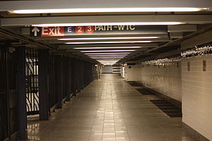
The station also connects to the PATH via the World Trade Center Transportation Hub, and to the nearby Fulton Center via the Dey Street Passageway.
History[]
IND Eighth Avenue Line[]
The Chambers Street and World Trade Center stations on the Eighth Avenue Line opened just after midnight on September 10, 1932, as the southern terminus of the city-operated Independent Subway System (IND)'s initial segment, the Eighth Avenue Line between Chambers Street–Hudson Terminal and 207th Street.[5][6] A late-1990s renovation saw prefabricated tile panels installed on the trackside wall of the express platform, with a tile band of Concord Violet bordered in black and "CHAMBERS" in white Copperplate lettering on black tiles on each panel, and on the local platform's walls the new tiles were installed in 3-foot by 2-foot sections with a slightly different shade of dark blue violet bordered in black; no station name captions were placed. The trim lines in the entryways and passages use the Concord Violet color rather than the blue violet.[citation needed]
Around 2:00 p.m. on January 23, 2005, a fire destroyed the interlocking plant at Chambers Street. As a result, two-thirds of A trains were canceled or rerouted, including all rush-hour trips to Rockaway Park–Beach 116th Street. C service was completely suspended and replaced by the A and V in Brooklyn and A, B, D, and E in Manhattan. Some newspaper articles blamed the fire on a homeless person trying to keep warm, but that was never confirmed.[7] Until January 28, the MTA rerouted the A to the Rutgers Street Tunnel during late nights. Initial estimates gave a time of three to five years to restore full service because the destroyed equipment was custom-made for the MTA.[8] That was later cut back to six to nine months to bring back normal operations. However, C service and 70% of A service was restored ten days after the fire, and the rush-hour A trips were restored on February 14, with full service returning on April 21. However, effects of the fire continued into 2006 because the equipment had not been replaced.[8]
IRT Broadway–Seventh Avenue Line[]
The Interborough Rapid Transit Company (IRT)'s Broadway–Seventh Avenue Line first opened as a shuttle to 34th Street–Penn Station on June 3, 1917.[9][10] The line was extended south to South Ferry on July 1, 1918; the Park Place station opened on the same date, and was served by a shuttle between Chambers Street and Wall Street, on the line's Brooklyn Branch.[11] The new "H" system was implemented on August 1, 1918, joining the two halves of the Broadway–Seventh Avenue Line and sending all West Side trains south from Times Square.[12] As a result, shuttle service to this station was replaced by through service.[13]
During the 1964–1965 fiscal year, the platforms at Park Place, along with those at four other stations on the Broadway–Seventh Avenue Line, were lengthened to 525 feet to accommodate a ten-car train of 51-foot IRT cars.[14]
Between April 3 and October 1, 1999, this station was closed for escalator replacement and a station rehabilitation.[15]
BMT Broadway Line[]
The Cortlandt Street station on the Brooklyn–Manhattan Transit Corporation (BMT)'s Broadway Line opened on January 5, 1918,[16] The station was overhauled in the late 1970s, with repairs made to the structural and cosmetic appearance. The original BMT wall tiles were removed and the "new" station walls contained cinderblock tiles (colored white with small recesses painted yellow), with black and white station-name signs bolted into the recesses. Lighting was converted from incandescent to fluorescent and staircases and platform edges were repaired. Much of the cosmetic change that came with this renovation was undone in an 1998–1999 renovation. In addition to "state-of-repair" work and upgrades for ADA accessibility, the station's original 1918 tilework was restored. Other improvements were made to the public address system, directional signage, and concrete trackbeds.

During the September 11 attacks in 2001, a train operator reported an "explosion" to the MTA's Subway Control Center one minute after the first plane struck the World Trade Center's North Tower at 8:46 a.m. Subway service was halted shortly afterward, and as a result, no one in the subway system died. The station sustained significant damage during the collapse of the World Trade Center. It was closed for repairs, which included removal of debris, fixing structural damage, and restoring the track beds, which had suffered flood damage in the aftermath of the collapse.[17] The station reopened on September 15, 2002.
On August 20, 2005, the station was closed again for installation of the Dey Street Passageway below Dey Street as part of the Fulton Center project. At the same time, the station was made ADA-accessible in both directions. Previously, the station was accessible on the southbound side only via the temporary PATH World Trade Center station's elevator. MTA posters and flyers at that time indicated the station would reopen in the spring of 2006, and later by spring of 2007, but neither reopening schedules occurred.[18] The northbound side of the station finally reopened on November 25, 2009.[19][20] The southbound platform reopened on September 6, 2011, while continuing excavation along the Church Street side of the World Trade Center site was being performed.[21][22][23]
The Dey Street Passageway, outside of the fare control, connects the Fulton Street station complex to the Cortlandt Street station and to the World Trade Center Transportation Hub. It opened on November 10, 2014, while the World Trade Center was still under construction.[24] With the opening of the Dey Street Passageway, ridership at the station nearly tripled, from 1,500,040 in 2014 to 4,270,036 in 2016.[3] On December 29, 2017, the Cortlandt Street station was connected to the other platforms in the complex. That date also saw the opening of a passageway connecting the World Trade Center station with 2 World Trade Center, and passageways connecting the southbound platform of Cortlandt Street to the Transportation Hub's Oculus head house and to 4 World Trade Center. Fare control areas had to be reconfigured.[25]
Station layout[]
Chambers Street–World Trade Center/Park Place[]
| G | Street level | Exit/entrance | |
| B1 | Mezzanine | Fare control, station agent
| |
| B2 | Northbound local | ← |
Passageway to |
| Island platform | |||
| Northbound local | ← | ||
| Northbound express | ← ← |
||
| Island platform | |||
| Southbound express | | ||
| B3 | Northbound | ← ← | |
| Island platform | |||
| Southbound | | ||
Cortlandt Street[]
| G | Street level | Vesey Street, West Broadway, Greenwich Street, September 11 Memorial and Museum |
| B1 Upper Concourse Broadway and 7th Avenue Line stations[26] |
Side platform | |
| Northbound | ← ← ← | |
| Southbound | | |
| Side platform | ||
| Balcony | Westfield World Trade Center; elevators, escalators, and stairs to lower concourse | |
| Side platform | ||
| Northbound | ← | |
| Southbound | | |
| Side platform | ||
| West Concourse Balcony | Shops, passageway to Brookfield Place | |
| B2 Lower Concourse[26] |
Subway passageway | |
| Subway crossunder | MetroCard machines, turnstiles and entrance to Broadway Line platforms | |
| Westfield World Trade Center | Shops and booths | |
| Subway crossunder | MetroCard machines, turnstiles and entrance to 7th Avenue Line platforms | |
| B3 Mezzanine[26] |
PATH fare control | MetroCard/SmartLink machines, access to PATH platforms |
| West Concourse | Shops, passageway to Brookfield Place | |
| B4 PATH platforms[26] | ||
| Track 1 | ← HOB–WTC rush hours toward Hoboken (Exchange Place) | |
| Island platform (Platform A) | ||
| Track 2[a] | ← HOB–WTC weekdays toward Hoboken (Exchange Place) | |
| Island platform (Platform B) | ||
| Track 3[b] | ← HOB–WTC weekdays toward Hoboken (Exchange Place) | |
| Track 4[c] | ← NWK–WTC toward Newark (Exchange Place) | |
| Island platform (Platform C) | ||
| Track 5[d] | ← NWK–WTC toward Newark (Exchange Place) | |
| Side platform (Platform D) | ||
Exits[]
Exits/entrances through turnstiles to Church Street are located in the mezzanine of the IND station, along with a few High Entrance-Exit Turnstiles (HEETs). There are street stairs:
- at all four corners of Church and Chambers Streets[27]
- at both western corners of Church and Warren Streets[27]
- at both western corners of Church and Murray Streets[27]
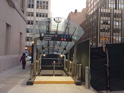
- at all four corners of Church Street and Park Place; there is also an elevator to the local platform at the southeastern corner[27]
- at the southwestern corner of Church and Barclay Streets[27]
- at the northwestern and southeastern corners of Church and Vesey Streets[27]
- at the northeastern corner of Church and Fulton Streets[27]
There is also a passageway to the PATH station at the very southern end of the local IND platform (see § Accessibility), providing ADA-accessible access to the local platform.[28][29]

The IRT platform has its own entrance/exit at its extreme eastern (railroad south) end. Here, a staircase and two escalators, none of which are together, lead up to a mezzanine just beneath the street. The staircase splits into two separate staircases at an initial landing and each of those have another intermediate landing. On this mezzanine, there are turnstiles, both regular and HEET (from when the mezzanine had a part-time token booth and the regular turnstiles could not be left unstaffed). A single street stair leads out to the northwest corner of Broadway and Park Place. The signage for this entrance is the only one in the complex that says "Park Place" with bullets only for the 2 and 3 trains. This stair is very close to the BMT Broadway Line's City Hall station, an entrance to which is about 200 feet (61 m) away, on the other side of Broadway.[27] A short staircase in that mezzanine once led to an entrance to the lobby of the Woolworth Building. It has been closed since the September 11 attacks.
Both eastern corners of Church and Dey Streets contain a staircase exit from the northbound BMT platform, and a staircase to the northeast corner of Church and Cortlandt Streets leads to the same platform.[30] The BMT platform is ADA-accessible via the Dey Street Passageway, an underpass that runs to the World Trade Center Transportation Hub and the Fulton Center.[30] An underground passageway also leads to One Liberty Plaza.[30] An exit at the north end of the southbound BMT platform once led to the original World Trade Center's lower concourse, and now leads to the Westfield World Trade Center shopping mall and the World Trade Center subway station.[25]
| hide Lower Manhattan transit | ||||||||||||||||||||||||||||||||||||||||||||||||||||||||||||||||||||||||||||||||||||||||||||||||||
|---|---|---|---|---|---|---|---|---|---|---|---|---|---|---|---|---|---|---|---|---|---|---|---|---|---|---|---|---|---|---|---|---|---|---|---|---|---|---|---|---|---|---|---|---|---|---|---|---|---|---|---|---|---|---|---|---|---|---|---|---|---|---|---|---|---|---|---|---|---|---|---|---|---|---|---|---|---|---|---|---|---|---|---|---|---|---|---|---|---|---|---|---|---|---|---|---|---|---|
| ||||||||||||||||||||||||||||||||||||||||||||||||||||||||||||||||||||||||||||||||||||||||||||||||||
IND Eighth Avenue Line platforms[]
Chambers Street–World Trade Center on the IND Eighth Avenue Line is an express station with four tracks and two island platforms, but in an unusual layout: the station has separate island platforms for through and terminating trains.[31] Both island platforms can accommodate 600-foot (180 m) trains. There is a passenger connection between the two platforms at mezzanine level. This passageway also includes the in-system transfer to the IRT station. The only transfer between the local platform and the express platform is available only at the very tips of both platforms, where the two platforms are opposite each other for a few feet. Passengers must walk down the express platform to the southernmost staircase, go up to a different part of the mezzanine, crossover, and then go down a staircase to the northern end of the local platform. This complex transfer is to allow a continued underground mezzanine outside of fare control from the southern end at the World Trade Center, which is just one block west of the Fulton Street station on the IND Eighth Avenue Line, to the most northern street stairs at Chambers and Church Street, which is just one block east of the Chambers Street station of the IRT Broadway–Seventh Avenue Line.[27] The total length of the mezzanine is seven blocks.
Chambers Street[]
Chambers Street | |||
|---|---|---|---|
 Express platform | |||
| Station statistics | |||
| Address | Church Street between Chambers Street & Vesey Street New York, NY 10007 | ||
| Borough | Manhattan | ||
| Locale | Financial District | ||
| Division | B (IND)[32] | ||
| Line | IND Eighth Avenue Line | ||
| Services | A C | ||
| Platforms | 1 island platform | ||
| Tracks | 2 | ||
| Other information | |||
| Opened | September 10, 1932[5] | ||
| Station code | 170[2] | ||
| Accessible | |||
| Opposite- direction transfer | Yes | ||
| Station succession | |||
| Next north | Canal Street: A | ||
| Next south | Fulton Street: A | ||
| |||
Chambers Street is assigned to the through platform. Just north of Chambers Street is a third track between the uptown and downtown express tracks, with connecting switches at both ends, which was used to turn trains when Chambers Street was used as a terminal,[33] before the Broadway–Nassau Street (now Fulton Street) station opened on February 1, 1933.[34] It is served by the A and C trains. This platform is not wheelchair-accessible, although it can possibly gain accessibility in the future because the elevator to the local platform leads to the mezzanine that is shared with this station. However, it is one block away from the Chambers Street station on the IRT Broadway–Seventh Avenue Line, which is wheelchair-accessible.
| hide Track layout | |||||||||||||||||||||||||||||||||||||||||||||||||||||||||||||||||||||||||||||||||||||||||||||||||||||||||||||||||||||||||||||||||||||||||||||||||||
|---|---|---|---|---|---|---|---|---|---|---|---|---|---|---|---|---|---|---|---|---|---|---|---|---|---|---|---|---|---|---|---|---|---|---|---|---|---|---|---|---|---|---|---|---|---|---|---|---|---|---|---|---|---|---|---|---|---|---|---|---|---|---|---|---|---|---|---|---|---|---|---|---|---|---|---|---|---|---|---|---|---|---|---|---|---|---|---|---|---|---|---|---|---|---|---|---|---|---|---|---|---|---|---|---|---|---|---|---|---|---|---|---|---|---|---|---|---|---|---|---|---|---|---|---|---|---|---|---|---|---|---|---|---|---|---|---|---|---|---|---|---|---|---|---|---|---|---|
| |||||||||||||||||||||||||||||||||||||||||||||||||||||||||||||||||||||||||||||||||||||||||||||||||||||||||||||||||||||||||||||||||||||||||||||||||||
World Trade Center[]
World Trade Center | |||
|---|---|---|---|
 Local platform | |||
| Station statistics | |||
| Address | Church Street between Chambers Street & Vesey Street New York, NY 10007 | ||
| Borough | Manhattan | ||
| Locale | Financial District | ||
| Division | B (IND)[35] | ||
| Line | IND Eighth Avenue Line | ||
| Services | E | ||
| Platforms | 1 island platform | ||
| Tracks | 2 | ||
| Other information | |||
| Opened | September 10, 1932[5] | ||
| Station code | 171[2] | ||
| Accessible | |||
| Opposite- direction transfer | N/A | ||
| Former/other names | Hudson Terminal | ||
| Station succession | |||
| Next north | Canal Street: E | ||
| Next south | (Terminal): E | ||
| |||
World Trade Center is the name given to the terminating platform.[33] It is served by the E train. Southbound local trains reach the platform by ramping underneath the express tracks south of Canal Street station. The northern end of the World Trade Center station has a signal tower and a diamond crossover switch that are roughly at the middle of the through-platform.
The local tracks end at bumper blocks at the south end of the platform. In addition, there is a platform-level passageway on the western side of the station toward the platform's south end, evidence of a former half-length side platform for the western track; while in passenger use as a connection to the rest of the station, the former platform is now fenced off from the rest of the local platform level, and passengers must now use the mezzanine to access the island platform.[36] A connection to the World Trade Center Transportation Hub is also available at the station's south end;[28] this, in turn, gives access to the Fulton Center (via the Dey Street Passageway), the Cortlandt Street station of the BMT Broadway Line, and the WTC Cortlandt Street station on the IRT Broadway–Seventh Avenue Line.[37] Another passageway also leads directly to the southbound BMT Broadway Line platform.
The station was formerly named Hudson Terminal or H&M, after the nearby Hudson Terminal of the Hudson and Manhattan Railroad (now the PATH). Since 1973, this station has been named after the two World Trade Centers. Wall tiles reading "H AND M" remained on the walls of the World Trade Center station as late as December 1974,[38] a year after the first World Trade Center was completed. The tiles were initially painted over, but since the station's renovation, they have been covered over.
Accessibility[]

At the extreme southern end of the station is the exit to the Cortlandt Street station,[28][29] along with a few High Entrance-Exit Turnstiles (HEETs). Only this platform is ADA-accessible via a ramp installed in 1987, making the station one of the earliest in the New York City Subway system to be accessible to disabled users.
The doors and original ADA-accessible ramp, as well as the structure from the first World Trade Center leading into the station, survived the September 11 attacks.[29] The station itself was not damaged, but it was covered by dust and was subsequently closed.[39] The passageway reopened for a while to provide an ADA-connection from the New York City Subway station to the temporary World Trade Center PATH station, but was closed again when the temporary PATH station closed for a reconstruction.[39] The passageway was then covered in plywood for preservation purposes.[28]
The renovated entrance, leading from the New York City Subway station to the newly rebuilt PATH station's Oculus headhouse as well as to the Westfield World Trade Center, opened on December 19, 2016.[29][39] The newly reopened passageway retained its pre-9/11 design, save for a door on display that has the words "MATF 1 / 9 13" spray-painted on it (a message from Urban Search and Rescue Massachusetts Task Force 1 of Beverly, Massachusetts, who searched the World Trade Center site on September 13, 2001). There is a plaque above the spray-painting, explaining the message on the door.[28] PATH was required to preserve the passageway's original design as per Section 106 of the National Historic Preservation Act, as a condition for getting funding to construct the Oculus and new stations. The passageway was not made ADA-accessible again until 2017, as there are twenty-six steps down from the mezzanine to the Oculus headhouse's lobby.[28]
The MTA's elevator to the local platform, at the southeast corner of Church Street and Park Place, connects to the local platform via a long ramp from the main mezzanine shared with Chambers Street, but it was out of service between 2001 and 2018 due to long-term construction on the current World Trade Center.[40]
Presentation on maps[]
The station has been portrayed in a variety of ways on New York City Subway maps since 1932. Originally, it was shown as a single station called Chambers Street–Hudson Terminal. Starting in about 1948, two stations were shown, Chambers Street–Hudson Terminal for the express trains continuing to Brooklyn, and Hudson Terminal for the local trains terminating at the station. A 1959 map showed two stations enclosed in a box, but a single label. The 1964 and 1966 maps were similar.
On the 1972 map, it once again appeared to be a single station, with the label showing Chambers Street, Hudson Terminal, World Trade Center, and PATH, although the Hudson Terminal office building complex had already been demolished by this time.
On the current map[41] published by the Metropolitan Transportation Authority, it is shown as two separate stations with a free transfer—Chambers Street (served by the A and C trains) and World Trade Center (served by the E train). Signs in the Fulton Center only show the E when pointing toward the World Trade Center station, as the A, C, 2 and 3 trains serve both station complexes.
Oculus mosaics []
There are over 300 mosaics dispersed throughout the IND and IRT stations, which are part of the 1998 installation Oculus created by Kristin Jones and Andrew Ginzel. These eyes were modeled on photographs of the eyes of hundreds of New Yorkers.[42]
According to Jones and Ginzel,
Oculus is a constellation of stone and glass mosaics in the underground labyrinth of interconnected subway stations of lower Manhattan. Over three hundred mosaic eyes, drawn from a photographic study of more than twelve hundred young New Yorkers, are set into the white tile walls of the World Trade Center/Park Place/Chamber Street Stations. The work's centerpiece is a large exquisitely detailed, elliptical glass and stone mosaic floor (38 ft 8 in x 20'8") at the heart of the Park Place Station. The continents of the earth, interwoven with the City of New York amidst an ultramarine pool, surround a large eye in the middle of the mosaic. The mosaic is at once a vision of the world, a reflecting pool of water and a representation New York City in its proper geographical orientation.
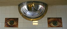 The eyes of "Oculus"
The work's detailed renderings of the eye–the most telling, fragile and vulnerable human feature–offer a profound sense of intimacy within a public place. Together, the images create a sense of unity and flow: animating, orienting and humanizing the station. Oculus invites a dialogue between the site and those who move through it.
Oculus was realized in collaboration with the Roman mosaicist, Rinaldo Piras, Sectile.[43]

IRT Broadway–Seventh Avenue Line platform[]
Park Place | |||
|---|---|---|---|
 | |||
| Station statistics | |||
| Address | Park Place & Broadway New York, NY 10007 | ||
| Borough | Manhattan | ||
| Locale | Financial District | ||
| Division | A (IRT)[44] | ||
| Line | IRT Broadway–Seventh Avenue Line | ||
| Services | 2 3 | ||
| Platforms | 1 island platform | ||
| Tracks | 2 | ||
| Other information | |||
| Opened | July 1, 1918 | ||
| Station code | 331[2] | ||
| Accessible | |||
| Opposite- direction transfer | Yes | ||
| Station succession | |||
| Next north | Chambers Street: 2 | ||
| Next south | Fulton Street: 2 | ||
| |||
| |||
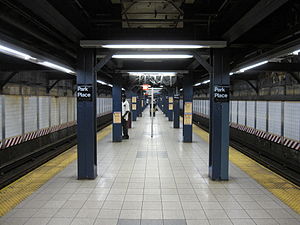
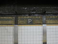
The Park Place station on the IRT Broadway–Seventh Avenue Line was built on the portion of the line built as part of the Dual Contracts, which is the section south of Times Square–42nd Street. It has two tracks and a single island platform with a line of blue i-beam columns with alternating ones having the standard black name plate in white lettering. Both track walls have a mostly gold trim line along with the "P" tablets at regular intervals.
Northwest (railroad north) of the station, the tracks of this station become the express tracks of the IRT Broadway–Seventh Avenue Line, curving sharply northeast under West Broadway.[33] The station is very close to the next stop north, Chambers Street at West Broadway, and the northernmost entrances of this station at Church and Chambers Streets are less than 400 feet (120 m) from the entrances to the station at Chambers Street and West Broadway.[27]
The station has a mezzanine at each end. Towards the western end of the platform, two long staircases lead up to an intermediate landing where another, shorter staircase leads up to the main IND mezzanine near the full Oculus mosaic. From here, there is a bank of turnstiles leading to the street stair that goes to the northwest corner of Park Place and Church Street. A staircase in this mezzanine leads down to the very southern end of the IND express platform, where transfer to the local platform is via another set of stairs.[27]
Track wall mosaic
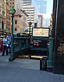
Entrance at Park Place & Broadway


BMT Broadway Line platforms[]
Cortlandt Street | |||
|---|---|---|---|
 Downtown platform | |||
| Station statistics | |||
| Address | Cortlandt Street & Church Street New York, NY 10280 | ||
| Borough | Manhattan | ||
| Locale | Financial District, World Trade Center | ||
| Division | B (BMT)[45] | ||
| Line | BMT Broadway Line | ||
| Services | N R W | ||
| Structure | Underground | ||
| Platforms | 2 side platforms | ||
| Tracks | 2 | ||
| Other information | |||
| Opened | January 5, 1918[16] (original) September 15, 2002 (first reopening) | ||
| Closed | September 11, 2001 (first closing) August 20, 2005 (second closing) | ||
| Rebuilt | November 25, 2009 (northbound platform)[46] September 6, 2011 (southbound platform)[22][23] | ||
| Station code | 021[2] | ||
| Accessible | |||
| Opposite- direction transfer | Yes | ||
| Former/other names | Cortlandt Street–World Trade Center | ||
| Station succession | |||
| Next north | City Hall: N | ||
| Next south | Rector Street: N | ||
| |||
| |||
Cortlandt Street is a local station on the BMT Broadway Line. The station is located under Church Street, between Fulton and Cortlandt Streets. It has two tracks and two side platforms.[33] It is the closest station on the BMT Broadway Line to the World Trade Center.[30] Immediately north of this station, the line utilizes a sharp reverse curve, first turning east under Vesey Street, then turning north under Broadway toward City Hall.[33]
Passageways link this station to three others outside fare control: the World Trade Center PATH station, the WTC Cortlandt station, and the Fulton Street station, all through the Dey Street Passageway underneath the station. The station also contains a free transfer to the Chambers Street–World Trade Center and Park Place stations via the southbound platform.

Name tablet mosaic
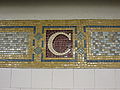
Monogram mosaic
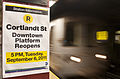
Poster announcing opening of the southbound platform
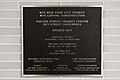
Plaque on the Dey Street Underpass

Dey Street Passageway entrance


| Fulton St to Cortlandt St subway cross-section | |||||||||
| Greenwich St | WTC Transportation Hub (Oculus) / Westfield Shops |
Church St | Broadway | Fulton Center / Westfield Shops |
Nassau St | William St | |||
| 1 | R / W | 4 / 5 | J / Z south | mezzanine | |||||
| underpass | underpass | Dey Street Passageway | underpass | mezzanine | J / Z north | mezzanine | 2 / 3 | ||
| mezzanine | ← A / C → | ||||||||
| PATH | |||||||||
Nearby points of interest[]
- Brookfield Place (formerly World Financial Center)[27]
- Battery Park City[27]
- Century 21 (also near the adjacent Fulton Street station)[27]
- Church Street Post Office[27]
- New York Public Library New Amsterdam Branch[27]
- Saks Fifth Avenue Downtown division[27]
- St. Paul's Chapel[27]
- Woolworth Building[27]
- World Trade Center buildings (see also World Trade Center site)[27]
Notes[]
References[]
- ^ "Glossary". Second Avenue Subway Supplemental Draft Environmental Impact Statement (SDEIS) (PDF). 1. Metropolitan Transportation Authority. March 4, 2003. pp. 1–2. Archived from the original (PDF) on February 26, 2021. Retrieved January 1, 2021.
- ^ Jump up to: a b c d e "Station Developers' Information". Metropolitan Transportation Authority. Retrieved June 13, 2017.
- ^ Jump up to: a b "Facts and Figures: Annual Subway Ridership 2014–2019". Metropolitan Transportation Authority. 2020. Retrieved May 26, 2020.
- ^ Jump up to: a b "Facts and Figures: Annual Subway Ridership 2014–2019". Metropolitan Transportation Authority. 2020. Retrieved May 26, 2020.
- ^ Jump up to: a b c "List of the 28 Stations on the New 8th Av. Line". The New York Times. September 10, 1932. p. 6. ISSN 0362-4331. Retrieved April 21, 2020.
- ^ Crowell, Paul (September 10, 1932). "Gay Midnight Crowd Rides First Trains In The New Subway: Throngs at Station an Hour Before Time, Rush Turnstiles When Chains are Dropped" (PDF). The New York Times. Retrieved November 8, 2015.
- ^ "Signal Room Fire Reroutes Trains on 3 Subway Lines". The New York Times. January 24, 2005. Retrieved July 6, 2016.
- ^ Jump up to: a b Chan, Sewell (January 25, 2006). "Year After Subway Fire, Damaged Equipment Is Still Not Replaced". The New York Times. Retrieved October 27, 2015.
- ^ "Three New Links of the Dual Subway System Opened, Including a Shuttle Service from Times Square to Thirty-Fourth Street — Service on the Jerome Avenue Branch From 149th Street North to About 225th Street Began Yesterday Afternoon — The Event Celebrated by Bronx Citizens and Property Owners — The Seventh Avenue Connection Opened This Morning" (PDF). The New York Times. June 3, 1917. p. 1. Retrieved November 6, 2016.
- ^ "Annual report. 1916-1917". HathiTrust. Interborough Rapid Transit Company. December 12, 2013. p. 22. Retrieved September 5, 2016.
- ^ "Open New Subway to Regular Traffic — First Train on Seventh Avenue Line Carries Mayor and Other Officials — To Serve Lower West Side — Whitney Predicts an Awakening of the District — New Extensions of Elevated Railroad Service" (PDF). The New York Times. July 2, 1918. p. 11. Retrieved November 6, 2016.
- ^ "Open New Subway Lines to Traffic; Called a Triumph — Great H System Put in Operation Marks an Era in Railroad Construction — No Hitch in the Plans — But Public Gropes Blindly to Find the Way in Maze of New Stations — Thousands Go Astray — Leaders in City's Life Hail Accomplishment of Great Task at Meeting at the Astor" (PDF). The New York Times. August 2, 1918. p. 1. Retrieved November 6, 2016.
- ^ Whitney, Travis H. (March 10, 1918). "The Seventh and Lexington Avenue Subways Will Revive Dormant Sections — Change in Operation That Will Transform Original Four-Tracked Subway Into Two Four-Tracked Systems and Double Present Capacity of the Interborough" (PDF). The New York Times. p. 12. Retrieved August 26, 2016.
- ^ Annual Report 1964–1965. New York City Transit Authority. 1965.
- ^ 2 3 All Times Park Place station closed Sat Apr 3 to Fri Oct 1. New York City Transit. April 1999.
- ^ Jump up to: a b "Open New Subway to Times Square". The New York Times. January 6, 1918. Retrieved April 12, 2007.
- ^ U.S. Department of Transportation, Research and Special Programs Administration, Volpe National Transportation Systems Center (April 2002). "Effects of Catastrophic Events on Transportation System Management and Operations: New York City- September 11". Archived from the original on March 5, 2013. Retrieved November 5, 2013.CS1 maint: multiple names: authors list (link)
- ^ "Cortlandt St station remains closed" (PDF). New York City Transit Authority. Archived from the original (PDF) on September 26, 2007. Retrieved April 12, 2007.
- ^ "MTA Chairman Reopens R/W Cortlandt Street Station". NY1 News. Archived from the original on June 30, 2012. Retrieved November 25, 2009.
- ^ "Cortlandt St Northbound Subway Platform Reopens". Lower Manhattan Construction Command Center/LMDC. Archived from the original on November 30, 2009. Retrieved November 22, 2009.
- ^ Fermino, Jennifer (August 3, 2011). "G. Zero station set to reopen". New York Post. Retrieved September 6, 2011.
- ^ Jump up to: a b "Cortlandt St. R Station Re-Opens". MTA.info. September 6, 2011. Retrieved September 7, 2011.
- ^ Jump up to: a b Fink, Zack (September 6, 2011). "Lower Manhattan Subway Stop Fully Reopened". NY1. Retrieved September 7, 2011.
- ^ "Fulton Street Transit Center, Final Environmental Impact Statement and Section 4(f) Evaluation, Ch. 3, p. 3-21" (PDF).
- ^ Jump up to: a b "Getting to the Oculus Just Got Much Easier". Tribeca Citizen. December 30, 2017. Retrieved January 3, 2018.
- ^ Jump up to: a b c d Dunlap, David W. (December 16, 2004). "Blocks; At Site of New Tower, a Game of Inches". The New York Times. Retrieved February 19, 2018 (a diagram is available here).CS1 maint: postscript (link)
- ^ Jump up to: a b c d e f g h i j k l m n o p q r s t "MTA Neighborhood Maps: Lower Manhattan" (PDF). mta.info. Metropolitan Transportation Authority. 2015. Retrieved October 1, 2018.
- ^ Jump up to: a b c d e f Dunlap, David W. (December 18, 2016). "A Vestige of the Original World Trade Center Returns to Duty". The New York Times. Retrieved December 19, 2016.
- ^ Jump up to: a b c d *Higgs, Larry (December 13, 2016). "When will the E Train be connected to WTC hub?". NJ.com. Retrieved December 16, 2016.
- "WTC Oculus E train access opens Monday". am New York. December 18, 2016. Retrieved December 19, 2016.
- ^ Jump up to: a b c d "MTA Neighborhood Maps: Lower Manhattan" (PDF). mta.info. Metropolitan Transportation Authority. 2015. Retrieved August 21, 2015.
- ^ Dougherty, Peter (2006) [2002]. Tracks of the New York City Subway 2006 (3rd ed.). Dougherty. OCLC 49777633 – via Google Books.
- ^ "Glossary". Second Avenue Subway Supplemental Draft Environmental Impact Statement (SDEIS) (PDF). 1. Metropolitan Transportation Authority. March 4, 2003. pp. 1–2. Archived from the original (PDF) on February 26, 2021. Retrieved January 1, 2021.
- ^ Jump up to: a b c d e Dougherty, Peter (2020). Tracks of the New York City Subway 2020 (16th ed.). Dougherty. OCLC 1056711733.
- ^ "City Opens Subway to Brooklyn Today". The New York Times. February 1, 1933. p. 19.
- ^ "Glossary". Second Avenue Subway Supplemental Draft Environmental Impact Statement (SDEIS) (PDF). 1. Metropolitan Transportation Authority. March 4, 2003. pp. 1–2. Archived from the original (PDF) on February 26, 2021. Retrieved January 1, 2021.
- ^ Photo of side platform in use, dated September 1, 1990
- ^ Yee, Vivian (November 9, 2014). "Out of Dust and Debris, a New Jewel Rises". The New York Times.
- ^ NYCSubway.org: Photograph of H&M/World Trade Center station dated December 12, 1974
- ^ Jump up to: a b c Tirella, Talia (December 18, 2016). "Long-closed passageway from original WTC to reopen on Monday". New York's PIX11 / WPIX-TV. Retrieved December 19, 2016.
- ^ "Transit and Bus Committee February 2017" (PDF). mta.info. Metropolitan Transportation Authority. February 21, 2017. Archived from the original (PDF) on February 22, 2017. Retrieved February 21, 2017.
- ^ "Subway Map" (PDF). Metropolitan Transportation Authority. July 2021. Retrieved January 18, 2018.
- ^ "www.nycsubway.org: IND 8th Avenue Line". www.nycsubway.org. Retrieved July 4, 2016.
- ^ Jones, Kristin; Ginzel, Andrew, Oculus, archived from the original on December 19, 2015, retrieved June 4, 2012
- ^ "Glossary". Second Avenue Subway Supplemental Draft Environmental Impact Statement (SDEIS) (PDF). 1. Metropolitan Transportation Authority. March 4, 2003. pp. 1–2. Archived from the original (PDF) on February 26, 2021. Retrieved January 1, 2021.
- ^ "Glossary". Second Avenue Subway Supplemental Draft Environmental Impact Statement (SDEIS) (PDF). 1. Metropolitan Transportation Authority. March 4, 2003. pp. 1–2. Archived from the original (PDF) on February 26, 2021. Retrieved January 1, 2021.
- ^ "Cortlandt Street R/W Subway Station Reopens". New York City Transit Authority. Retrieved November 26, 2009.
External links[]
| Wikimedia Commons has media related to Chambers Street – World Trade Center / Park Place / Cortlandt Street (New York City Subway). |
| External video | |
|---|---|
- nycsubway.org – IRT West Side Line: Park Place
- nycsubway.org – IND 8th Avenue: Chambers Street/World Trade Center
- nycsubway.org – New York City Subway Historical Maps:
- nycsubway.org – Oculus Artwork by Jones and Ginzel (1998)
- nycsubway.org – BMT Broadway Subway: Cortlandt Street – World Trade Center
- MTA's Arts For Transit – Chambers Street/Park Place
- MTA's Arts For Transit — Cortlandt Street (BMT Broadway Line)
| show Stations of the New York City Subway, by line (physical trackage) |
|---|
| show Stations of the New York City Subway, by service |
|---|
- Accessible New York City Subway stations
- 1918 establishments in New York (state)
- 1932 establishments in New York (state)
- BMT Broadway Line stations
- Financial District, Manhattan
- IND Eighth Avenue Line stations
- IRT Broadway–Seventh Avenue Line stations
- New York City Subway stations in Manhattan
- New York City Subway stations located underground
- New York City Subway terminals
- New York City Subway transfer stations
- Railway stations in the United States opened in 1918
- Railway stations in the United States opened in 1932
- Tribeca
- World Trade Center