Winthrop Street station
Winthrop Street | ||||||||||||||||||||||||||||||||||||||||||||||||||||||||||||||||||||
|---|---|---|---|---|---|---|---|---|---|---|---|---|---|---|---|---|---|---|---|---|---|---|---|---|---|---|---|---|---|---|---|---|---|---|---|---|---|---|---|---|---|---|---|---|---|---|---|---|---|---|---|---|---|---|---|---|---|---|---|---|---|---|---|---|---|---|---|---|
 Platform level | ||||||||||||||||||||||||||||||||||||||||||||||||||||||||||||||||||||
| Station statistics | ||||||||||||||||||||||||||||||||||||||||||||||||||||||||||||||||||||
| Address | Winthrop Street & Nostrand Avenue Brooklyn, NY 11225 | |||||||||||||||||||||||||||||||||||||||||||||||||||||||||||||||||||
| Borough | Brooklyn | |||||||||||||||||||||||||||||||||||||||||||||||||||||||||||||||||||
| Locale | Prospect Lefferts Gardens | |||||||||||||||||||||||||||||||||||||||||||||||||||||||||||||||||||
| Coordinates | 40°39′25″N 73°57′01″W / 40.657039°N 73.950262°WCoordinates: 40°39′25″N 73°57′01″W / 40.657039°N 73.950262°W | |||||||||||||||||||||||||||||||||||||||||||||||||||||||||||||||||||
| Division | A (IRT)[1] | |||||||||||||||||||||||||||||||||||||||||||||||||||||||||||||||||||
| Line | IRT Nostrand Avenue Line | |||||||||||||||||||||||||||||||||||||||||||||||||||||||||||||||||||
| Services | 2 5 | |||||||||||||||||||||||||||||||||||||||||||||||||||||||||||||||||||
| Transit | ||||||||||||||||||||||||||||||||||||||||||||||||||||||||||||||||||||
| Structure | Underground | |||||||||||||||||||||||||||||||||||||||||||||||||||||||||||||||||||
| Platforms | 2 side platforms | |||||||||||||||||||||||||||||||||||||||||||||||||||||||||||||||||||
| Tracks | 2 | |||||||||||||||||||||||||||||||||||||||||||||||||||||||||||||||||||
| Other information | ||||||||||||||||||||||||||||||||||||||||||||||||||||||||||||||||||||
| Opened | August 23, 1920 | |||||||||||||||||||||||||||||||||||||||||||||||||||||||||||||||||||
| Station code | 355[2] | |||||||||||||||||||||||||||||||||||||||||||||||||||||||||||||||||||
| Opposite- direction transfer | No | |||||||||||||||||||||||||||||||||||||||||||||||||||||||||||||||||||
| Traffic | ||||||||||||||||||||||||||||||||||||||||||||||||||||||||||||||||||||
| 2019 | 1,882,065[4] | |||||||||||||||||||||||||||||||||||||||||||||||||||||||||||||||||||
| Rank | 250 out of 424[4] | |||||||||||||||||||||||||||||||||||||||||||||||||||||||||||||||||||
| Station succession | ||||||||||||||||||||||||||||||||||||||||||||||||||||||||||||||||||||
| Next north | Sterling Street: 2 | |||||||||||||||||||||||||||||||||||||||||||||||||||||||||||||||||||
| Next south | Church Avenue: 2 | |||||||||||||||||||||||||||||||||||||||||||||||||||||||||||||||||||
| ||||||||||||||||||||||||||||||||||||||||||||||||||||||||||||||||||||
| ||||||||||||||||||||||||||||||||||||||||||||||||||||||||||||||||||||
| ||||||||||||||||||||||||||||||||||||||||||||||||||||||||||||||||||||
| ||||||||||||||||||||||||||||||||||||||||||||||||||||||||||||||||||||


The Winthrop Street station is a station on the IRT Nostrand Avenue Line of the New York City Subway, located in Brooklyn at the intersection of Winthrop Street and Nostrand Avenue. The station is served by the 2 train at all times and the 5 train on weekdays.
History[]
The Dual Contracts, which were signed on March 19, 1913, were contracts for the construction and/or rehabilitation and operation of rapid transit lines in the City of New York. The Dual Contracts promised the construction of several lines in Brooklyn. As part of Contract 4, the IRT agreed to build a subway line along Nostrand Avenue in Brooklyn.[5][6][7] The construction of the subway along Nostrand Avenue spurred real estate development in the surrounding areas.[8] The Nostrand Avenue Line opened on August 23, 1920, and the Winthrop Street station opened along with it.[9]
From 1962 to 1964, the platforms at Winthrop Street were extended at either end to 510 feet (160 m) so that they could accommodate 10-car trains. Platforms at other stations along the Nostrand Avenue Line were extended at this time.[10][11][12]
The Flatbush Avenue-bound platform closed from March 18, 2019, and reopened to the public on July 1, 2019.[13] This was so a staircase to the platform could be replaced.[14][15] Upon the Flatbush Avenue-bound platform's reopening, the Manhattan-bound platform closed until July 29, 2019.
Station layout[]
| G | Street level | Exit/entrance |
| P Platform level |
Side platform | |
| Northbound | ← ← | |
| Southbound | | |
| Side platform | ||

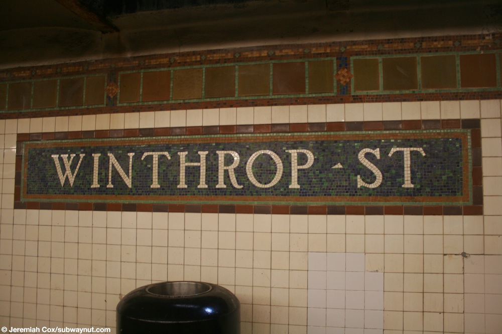
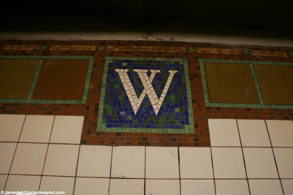
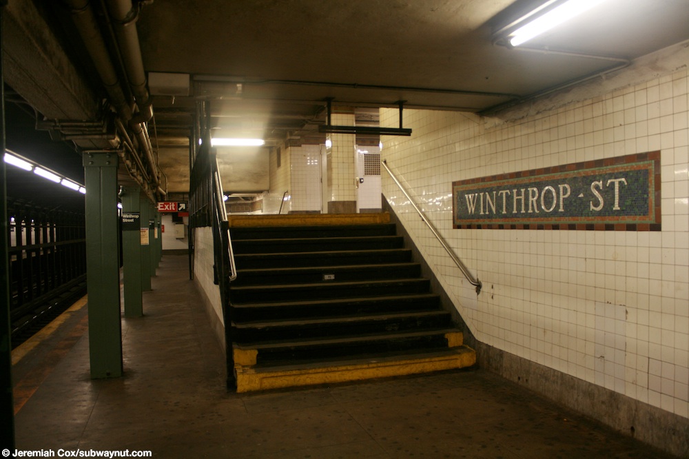
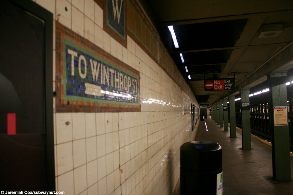
This underground station has two tracks and two side platforms which are slightly offset.[16] Both platforms have their original 1920s Dual Contracts era tiling. The name tablets read "WINTHROP ST." in gold lettering on a blue background with a green and brown border. The trim line consists of a light brown center surrounded by green lines and a darker brown border.[17] "W" tablets on a blue background and brown border run along the trim line at regular intervals.[18]
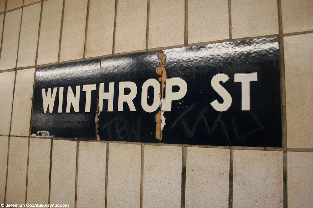
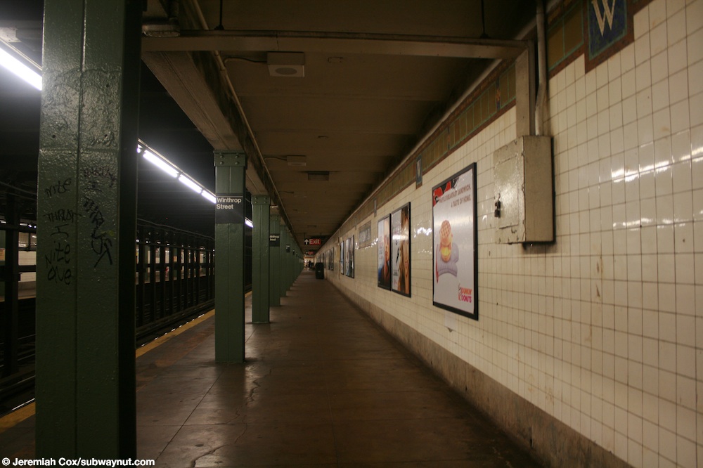
At either ends of each platform, where they were extended in the 1960s to accommodate the current standard "A" Division train length of 510 feet (160 m), there are white tiles with name tablets reading "WINTHROP ST" in white sans serif face spelled on a blue background at regular intervals.[19] All columns in the station are I-beams and are painted green.[20]
Exits[]
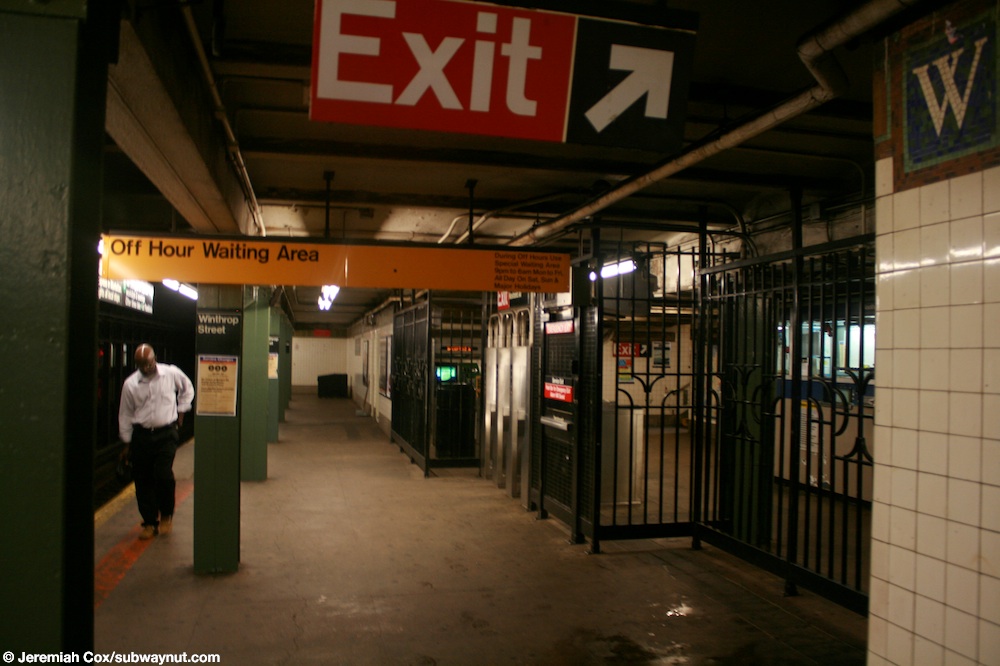
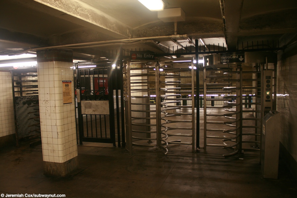
Each platform has one fare control area one block apart from each other and there are no crossovers or crossunders to allow free transfers between directions.[21] The one on the Manhattan-bound side, located on platform level, has a turnstile bank, token booth, and one staircase going up to the northeast corner of Winthrop Street and Nostrand Avenue.[22][23][24]
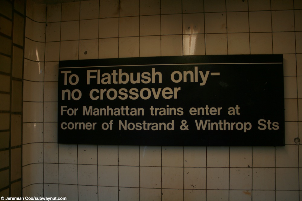
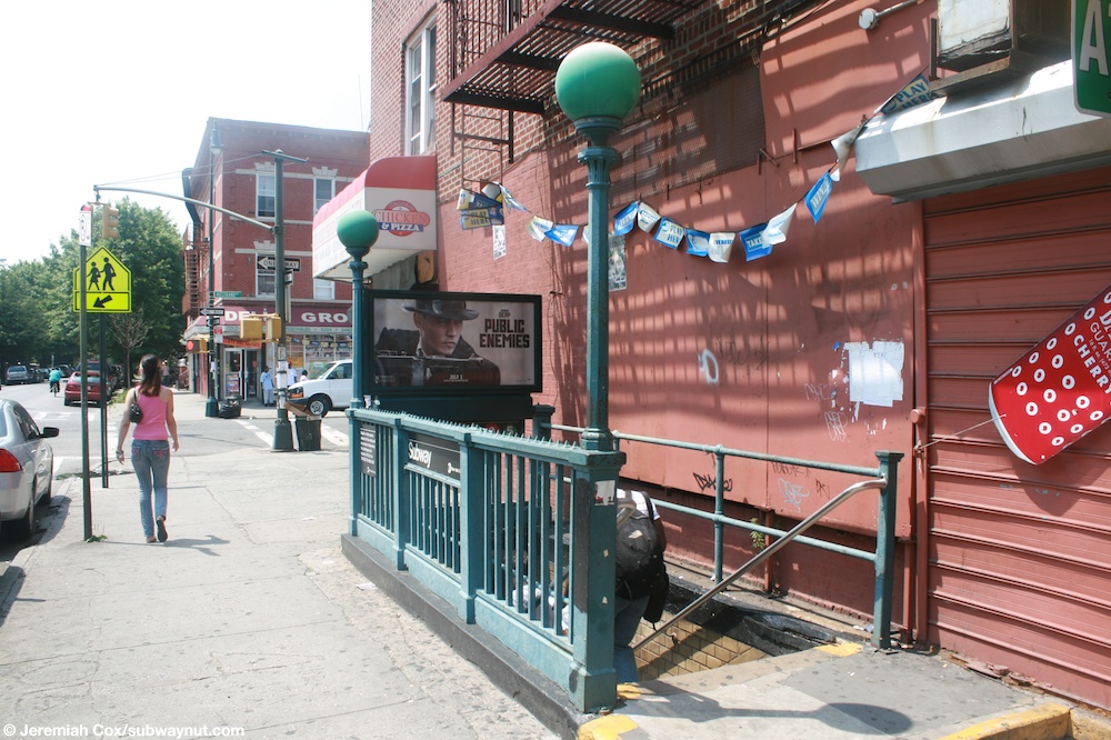
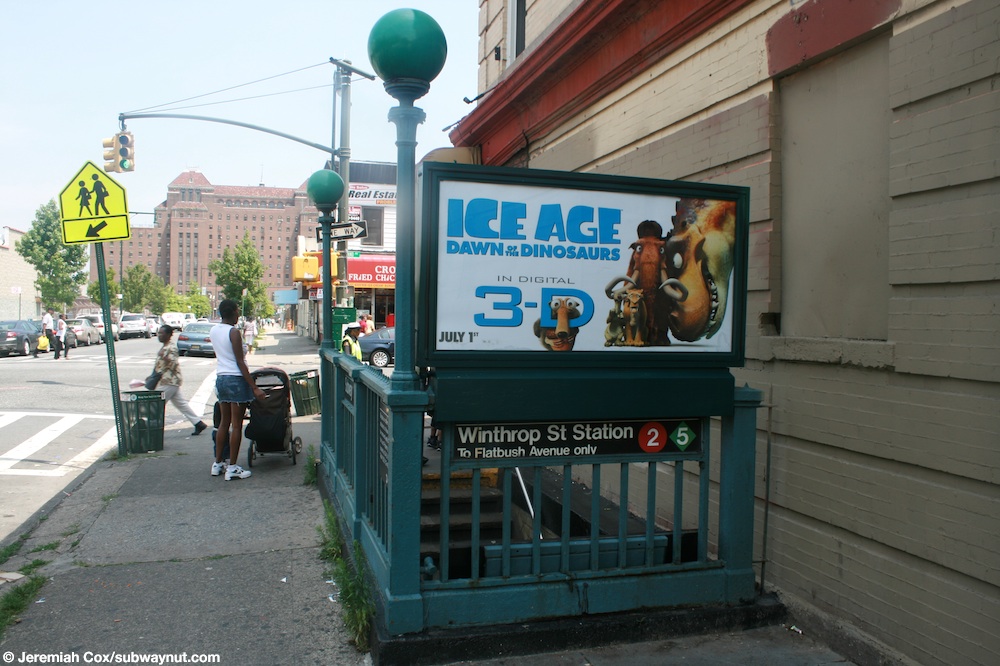
The fare control area on the Flatbush Avenue-bound platform is unstaffed. Two ten-step staircases go up to a mezzanine[25] where two exit-only turnstiles and one High Entry/Exit Turnstiles provides access to/from the station.[26] Outside fare control, there is a single staircase going up to the southwest corner of Parkside and Nostrand Avenues, one block south of the staircase to the Manhattan-bound fare control area.[27] Mosaic directional signs on the southbound platform indicate that it used to have an exit to Winthrop Street as well.[22][28]
| Exit location[22] | Exit type | Number of exits | Platform served |
|---|---|---|---|
| SW corner of Nostrand Avenue and Parkside Avenue | Staircase | 1 | Southbound |
| NE corner of Nostrand Avenue and Winthrop Street | Staircase | 1 | Northbound |
References[]
- ^ "Glossary". Second Avenue Subway Supplemental Draft Environmental Impact Statement (SDEIS) (PDF). Vol. 1. Metropolitan Transportation Authority. March 4, 2003. pp. 1–2. Archived from the original (PDF) on February 26, 2021. Retrieved January 1, 2021.
- ^ "Station Developers' Information". Metropolitan Transportation Authority. Retrieved June 13, 2017.
- ^ "Facts and Figures: Annual Subway Ridership 2014–2019". Metropolitan Transportation Authority. 2020. Retrieved May 26, 2020.
- ^ a b "Facts and Figures: Annual Subway Ridership 2014–2019". Metropolitan Transportation Authority. 2020. Retrieved May 26, 2020.
- ^ "Terms and Conditions of Dual System Contracts". nycsubway.org. Retrieved February 16, 2015.
- ^ "The Dual System of Rapid Transit (1912)". nycsubway.org.
- ^ "Most Recent Map of the Dual Subway System WhIch Shows How Brooklyn Borough Is Favored In New Transit Lines". Brooklyn Daily Eagle. September 9, 1917. Retrieved August 23, 2016 – via Brooklyn Newspapers.
- ^ "Big Eastern Parkway Deal". Brooklyn Daily Eagle. July 1, 1915. Retrieved August 23, 2016 – via Brooklyn Newspapers.
- ^ "Brooklyn Tube Extensions Open: I.R.T. Begins Service on Eastern Parkway and Nostrand Avenue Lines" (PDF). New York Times. August 23, 1920. Retrieved February 28, 2010.
- ^ Authority, New York City Transit (1967). Minutes and Proceedings. p. 152.
- ^ Annual Report For The Year Ending June 30, 1963. New York City Transit Authority. 1963. p. 14.
- ^ Annual Report For The Year Ending June 30, 1964. New York City Transit Authority. 1964. p. 10.
- ^ "5 Line - Weekday and Weekend Planned Service Change Update". mymtaalerts.com. Metropolitan Transportation Authority. July 1, 2019. Archived from the original on July 1, 2019. Retrieved July 1, 2019.
- ^ "Service Alert: Southbound Winthrop Street Train Station To Close For Three Months". BKLYNER. March 4, 2019. Retrieved March 14, 2019.
- ^ "Service Information". MTA. March 14, 2019. Archived from the original on March 14, 2019. Retrieved March 14, 2019.
- ^ Dougherty, Peter (2006) [2002]. Tracks of the New York City Subway 2006 (3rd ed.). Dougherty. OCLC 49777633 – via Google Books.
- ^ Cox, Jeremiah (July 22, 2009). "A Winthrop St name tablet". subwaynut.com. Retrieved February 18, 2018.
- ^ Cox, Jeremiah (July 22, 2009). "A close up of a W in the trimline at Winthrop Street". subwaynut.com. Retrieved February 18, 2018.
- ^ Cox, Jeremiah (July 22, 2009). "A close up of 1950s blocky Winthrop St text on the extreme southern end of the Manhattan-bound platform". subwaynut.com. Retrieved February 18, 2018.
- ^ Cox, Jeremiah (July 22, 2009). "Looking down the long Manhattan-bound platform at Winthrop Street, the platform's single exit is nowhere in site". subwaynut.com. Retrieved February 18, 2018.
- ^ Cox, Jeremiah (July 22, 2009). "A sign at the bottom of the street stair warns passengers again, it says To Flatbush only-no crossover: For Manhattan trains enter at corner of Nostrand & Winthrop Sts". subwaynut.com. Retrieved February 18, 2018.
- ^ a b c "MTA Neighborhood Maps: Crown Heights" (PDF). mta.info. Metropolitan Transportation Authority. 2015. Retrieved January 1, 2017.
- ^ Cox, Jeremiah (July 22, 2009). "On the street at the corner of Winthrop Street & Nostrand Avenue, the single street stair for Manhattan-bound trains". subwaynut.com. Retrieved February 18, 2018.
- ^ Cox, Jeremiah (July 22, 2009). "Approaching the single bank of turnstiles and exit to street from the Manhattan-bound platform at Winthrop St". subwaynut.com. Retrieved February 18, 2018.
- ^ Cox, Jeremiah (July 22, 2009). "Looking up one of two short staircases from the platform to the small upper level where the exit from the Flatbush-bound platform at Winthrop Street". subwaynut.com. Retrieved February 18, 2018.
- ^ Cox, Jeremiah (July 22, 2009). "The single High Entrance Turnstile provides the only way to board Flatbush Av-bound trains at Winthrop Street, there also two High Exit Turnstiles for passengers leaving the subway system". subwaynut.com. Retrieved February 18, 2018.
- ^ Cox, Jeremiah (July 22, 2009). "The street stair at the corner of Winthrop St & Prospect Av. It's the only entrance to Flatbush Avenue 2 <5> trains". subwaynut.com. Retrieved February 18, 2018.
- ^ Cox, Jeremiah (July 22, 2009). "An arrow beneath a sign for a functional exit 'To Winthrop Street' on the Flatbush-bound platform points towards a No Exit: Exit at other end sign". subwaynut.com. Retrieved February 18, 2018.
External links[]
| Wikimedia Commons has media related to Winthrop Street (IRT Nostrand Avenue Line). |
- nycsubway.org – Brooklyn IRT: Winthrop Street
| Nostrand Ave. Line | |
|---|---|
| |
- IRT Nostrand Avenue Line stations
- New York City Subway stations in Brooklyn
- Railway stations in the United States opened in 1920
- 1920 establishments in New York City
- Flatbush, Brooklyn
- New York City Subway stations located underground