Borough Hall/Court Street station
Borough Hall/Court Street | |||
|---|---|---|---|
 | |||
| Station statistics | |||
| Address | Court Street between Joralemon Street & Montague Street Brooklyn, NY 11201 | ||
| Borough | Brooklyn | ||
| Locale | Downtown Brooklyn, Brooklyn Heights | ||
| Coordinates | 40°41′37″N 73°59′25″W / 40.69361°N 73.99028°WCoordinates: 40°41′37″N 73°59′25″W / 40.69361°N 73.99028°W | ||
| Division | A (IRT), B (BMT)[1] | ||
| Line | BMT Fourth Avenue Line IRT Broadway–Seventh Avenue Line IRT Eastern Parkway Line | ||
| Services | 2 3 4 5 N R W | ||
| Transit | |||
| Levels | 3 | ||
| Other information | |||
| Opened | July 1, 1948[2] | ||
| Station code | 620[3] | ||
| Accessible | |||
| Traffic | |||
| 2019 | 10,135,722[4] | ||
| Rank | 28 out of 424[4] | ||
| |||
| |||
| |||


Borough Hall/Court Street is an underground New York City Subway station complex shared by the BMT Fourth Avenue Line, the IRT Broadway–Seventh Avenue Line and the IRT Eastern Parkway Line. The complex comprises three stations: Borough Hall on the IRT lines and Court Street on the BMT line. Located at the intersection of Court, Joralemon and Montague Streets at the border of Downtown Brooklyn and Brooklyn Heights, it is served by the 2, 4 and R trains at all times; the 3 train all times except late nights; the 5 train on weekdays the N train during late nights; and limited rush hour W trains.
The Borough Hall station of the Eastern Parkway Line was built for the Interborough Rapid Transit Company (IRT) as part of the city's first subway line. The station opened on January 9, 1908, as part of an extension of the original IRT into Brooklyn. The Borough Hall station of the Broadway–Seventh Avenue Line opened on April 15, 1919, as part of the Dual Contracts. The Court Street station of the Fourth Avenue Line was built for the Brooklyn Rapid Transit Company (later the Brooklyn–Manhattan Transit Corporation, or BMT) as part of the Dual Contracts, and opened on August 1, 1920. Several modifications have been made to both stations over the years, and they were connected within a single fare control area in 1948.
The Eastern Parkway Line station under Joralemon Street has two side platforms and two tracks on the same level. The Broadway–Seventh Avenue Line station under Brooklyn Borough Hall also has two side platforms and two tracks, but with the platforms on different levels. The Fourth Avenue Line station has one island platform and two tracks. Part of the complex is compliant with the Americans with Disabilities Act of 1990. The original portion of the interior of the Eastern Parkway Line's Borough Hall station is a New York City designated landmark and listed on the National Register of Historic Places.
History[]
First subway[]
Planning for a subway line in New York City dates to 1864.[5]: 21 However, development of what would become the city's first subway line did not start until 1894, when the New York State Legislature authorized the Rapid Transit Act.[5]: 139–161 The subway plans were drawn up by a team of engineers led by William Barclay Parsons, chief engineer of the Rapid Transit Commission.[6]: 3 The Rapid Transit Construction Company, organized by John B. McDonald and funded by August Belmont Jr., signed the initial Contract 1 with the Rapid Transit Commission in February 1900,[7] in which it would construct the subway and maintain a 50-year operating lease from the opening of the line.[5]: 165 In 1901, the firm of Heins & LaFarge was hired to design the underground stations.[6]: 4 Belmont incorporated the Interborough Rapid Transit Company (IRT) in April 1902 to operate the subway.[5]: 162–191
Several days after Contract 1 was signed, the Board of Rapid Transit Railroad Commissioners instructed Parsons to evaluate the feasibility of extending the subway south to South Ferry, and then to Brooklyn. On January 24, 1901, the Board adopted a route that would extend the subway from City Hall to the Long Island Rail Road (LIRR)'s Flatbush Avenue terminal station (now known as Atlantic Terminal) in Brooklyn, via the Joralemon Street Tunnel under the East River.[8]: 83–84 [9]: 260–261 Contract 2, giving a lease of 35 years, was executed between the commission and the Rapid Transit Construction Company on September 11, 1902. Construction began at State Street in Manhattan on November 8, 1902.[5]: 162–191 Construction of the Joralemon Street Tunnel began in 1903.[10]
The Borough Hall station was the first underground subway station in Brooklyn. It opened on January 9, 1908, as the terminal for the extension of the IRT Lexington Avenue Line from Lower Manhattan.[11][12] The extension to Atlantic Avenue opened on May 1, 1908, completing the Contract 2 IRT line.[13]: 194 [14] Initially, the station was served by express trains along both the West Side (now the Broadway–Seventh Avenue Line to Van Cortlandt Park–242nd Street) and East Side (now the Lenox Avenue Line). The express trains, running to Atlantic Avenue, had their northern terminus at 242nd Street or West Farms (180th Street).[15] Lenox local trains to 145th Street served the station during late nights.[16]
To address overcrowding, in 1909, the New York Public Service Commission proposed lengthening platforms at stations along the original IRT subway.[17]: 168 As part of a modification to the IRT's construction contracts, made on January 18, 1910, the company was to lengthen station platforms to accommodate ten-car express and six-car local trains. In addition to $1.5 million (equivalent to $41.7 million in 2020) spent on platform lengthening, $500,000 (equivalent to $13,887,500 in 2020) was spent on building additional entrances and exits. It was anticipated that these improvements would increase capacity by 25 percent.[18]: 15 The northbound platform at the Borough Hall station was extended 125 feet (38 m) to the east, while the southbound platform was extended 140 feet (43 m) to the east.[18]: 116 On January 23, 1911, ten-car express trains began running on the East Side Line, and the next day, ten-car express trains began running on the West Side Line.[17]: 168 [19]
Dual Contracts[]
After the original IRT opened, the city began planning new lines. In 1913, as part of the Dual Contracts, the New York City Public Service Commission planned to split the original IRT system into three segments: two north-south lines, carrying through trains over the Lexington Avenue and Broadway–Seventh Avenue Lines, and a west-east shuttle under 42nd Street. This would form a roughly "H"-shaped system.[20] The Broadway–Seventh Avenue Line would split into two branches south of Chambers Street, one of which would turn eastward through Lower Manhattan, run under the East River via a new Clark Street Tunnel, and connect with the existing Contract 2 IRT Brooklyn Line at Borough Hall.[21][22] Construction of the Clark Street Tunnel began in 1914.[23]
The Lexington Avenue Line north of Grand Central–42nd Street opened on August 1, 1918, and all Eastern Parkway Line services were sent via the Lexington Avenue Line.[24] Less than a year later, on April 15, 1919, the Broadway–Seventh Avenue Line station opened when the Brooklyn branch of that line was extended from Wall Street in Manhattan to Atlantic Avenue in Brooklyn. Through service between the Brooklyn Line and the Broadway–Seventh Avenue Line was inaugurated with this extension.[25] In 1920, a project to construct a new entrance at the northwestern corner of Joralemon Street and Court Street was completed.[26] That year, the Eastern Parkway Line was extended east of Atlantic Avenue. The Joralemon Street Tunnel services, which had previously served all stops on the Eastern Parkway Line, became express services, while the Broadway–Seventh Avenue Line services ran local on the Eastern Parkway Line.[27][28]
Also planned under the Dual Contracts was the Broadway Line and Fourth Avenue Line of the Brooklyn Rapid Transit Company (BRT), subsequently the Brooklyn–Manhattan Transit Corporation (BMT). Under the Dual Contracts, the Whitehall–Montague Street route and the Montague Street Tunnel were to be built, connecting the Broadway Line in Manhattan and the Fourth Avenue subway under the Flatbush Avenue Extension to the west of the DeKalb Avenue station.[29] Construction of the tunnel began in 1914.[30] Service via the Montague Tunnel began on August 1, 1920, along with the opening of the Court Street station.[31][32]
Later years[]
Transfer passageways between the three stations were placed inside fare control on July 1, 1948.[2] The Eastern Parkway Line platforms were extended eastward in 1964, allowing the station to accommodate 10-car trains.[33]
In 1976, with funding from the Exxon Corporation, the Broadway–Seventh Avenue Line station, as well as three others citywide, received new "artfully humorous graffiti" murals and artwork.[34] Local designer Samuel Lebowitz received $5,000 to "improve the level of lighting in an exciting and light hearted way." Some "multicolored animated neon signs" were placed underneath transparent plastic screens; such signs included "an abstract eye that winks every five seconds" and another that looked to be "blow[ing] smoke rings."[34]
On weekdays between August 2, 2013 and September 15, 2014,[35][36] this station served as the northern terminal of the Brooklyn half of the divided R. Service ran in two sections: one section between Forest Hills and Whitehall Street–South Ferry, and the other between Court Street-Borough Hall and Bay Ridge–95th Street. This change was necessary to repair damage on the Montague Street Tunnel resulting from Hurricane Sandy.[37][38][39]
In June 2018, part of the Eastern Parkway Line station's ceiling collapsed, injuring a bystander.[40] The collapse necessitated expensive emergency repairs that would set the MTA back $8.3 million. A report found that the staff sent to inspect the station verified the defect existed in 2017, but underestimated its severity due to a lack of expertise in terracotta ceilings, nor was the issue escalated to engineers who were familiar with terracotta. The ceiling was over 100 years old. The MTA report suggested that special care be taken in the inspection of the thirteen subway stations that have terracotta ceilings due to the different properties when compared to concrete or steel.[40]
Station layout[]
| G | Street level | Exit/entrance |
| M | Mezzanine | Fare control, station agent |
| B2 | Northbound local | ← ← |
| Side platform | ||
| Side platform | ||
| Northbound express | ← ← | |
| Southbound express | | |
| Side platform | ||
| B3 | Southbound local | |
| Side platform | ||
| B4 | Northbound | ← ← ← |
| Island platform | ||
| Southbound | | |
There are three overpasses of the IRT Eastern Parkway Line platforms at the mezzanine level above the center of that station. The outer two overpasses have two fare control areas, one each on the north and south sides. The middle overpass is apassageway connecting the unpaid areas on the north and south sides, and has no access to the platforms. The central mezzanine has two bronze plaques commemorating the subway's arrival in Brooklyn: a plaque to the PSC on the west and a plaque celebrating the station's opening on the east. The plaques are installed within mosaic tablets with swag and floral designs.[41]: 4–5 A fourth overpass is at the extreme west end of the IRT Eastern Parkway Line platforms.[41]: 16
The center of the northbound Eastern Parkway Line platform has a passageway leading to the southern end of the northbound IRT Broadway–Seventh Avenue Line platform.[41]: 16 [42][43] At the northern end of the IRT Broadway–Seventh Avenue Line platform, there is another mezzanine above the upper platform level. This leads to the BMT platform and two public restrooms inside fare control. Two escalators and two staircases from this passageway go down to a landing above the eastern part of the platform.

The BMT Fourth Avenue Line platform has another exit at its extreme western end. From a landing above the platform, two elevators and a staircase go up to the western BMT mezzanine. The mezzanine has a part-time turnstile bank and customer assistance booth. Full height turnstiles provide entrance/exit from the mezzanine at all times.
Both Broadway–Seventh Avenue Line platforms are fully accessible under the Americans with Disabilities Act of 1990 (ADA). The northbound Eastern Parkway Line platform is ADA-accessible via the passageway connecting with the northbound Broadway–Seventh Avenue Line platform. However, the southbound Eastern Parkway Line platform and the Fourth Avenue Line platform are not accessible.[44] Accessibility for the southbound Eastern Parkway Line platform was proposed in February 2019 as part of the MTA's "Fast Forward" program.[45]
Exits[]
The main fare control for the IRT Broadway–Seventh Avenue Line and BMT Fourth Avenue Line platforms is at the west end of the platforms. Outside fare control, there is a token booth, two staircases going up to the southeast corner of Court and Montague Streets, and a staircase and elevator going up to Columbus Park, the entrance plaza of Brooklyn Borough Hall, on the east side of Court Street.[46]
The main fare control for the IRT Eastern Parkway Line platforms is at the center of the station. On the northbound side, the overpasses have full height turnstiles leading to two staircases, one each flanking Borough Hall's main entrance on the northeast corner of Court and Joralemon Streets.[46] The stairs flanking Borough Hall retain cast-iron hoods atop granite bases, which are part of the original design. The Borough Hall station is one of two stations to retain such hoods, the other being the Wall Street station in Manhattan.[41]: 6 On the southbound side, the overpasses have small turnstile banks, leading to a token booth and two staircases, going up to the southeast corner of Court and Joralemon Streets.[41]: 4 [46] The banisters on these staircases are made of concrete since they are outside the Brooklyn Municipal Building. The mezzanine has a large set of doors leading into the Municipal Building (this entrance was closed in February 1996 due to security concerns), and a now defunct bank teller window. On the northwest corner of the mezzanine, a passage led to Borough Hall.[41]: 4
The secondary fare control area for the IRT Eastern Parkway Line is at the extreme west end. Outside fare control, there is a token booth. Past the booth, one stair each goes up to the northwest and southwest corners of Court and Joralemon Streets.[41]: 16 [46]
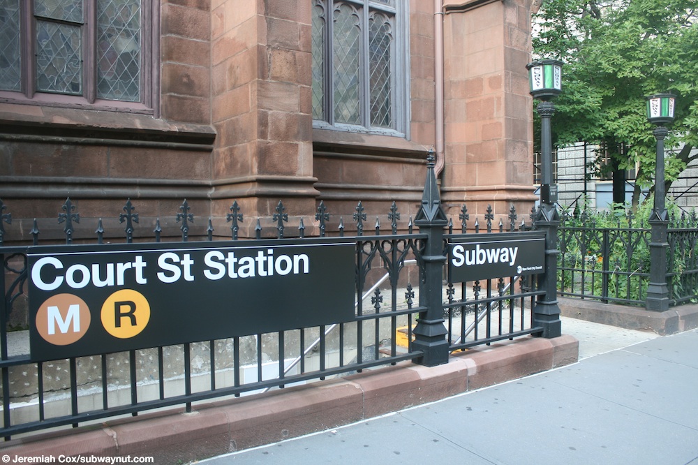
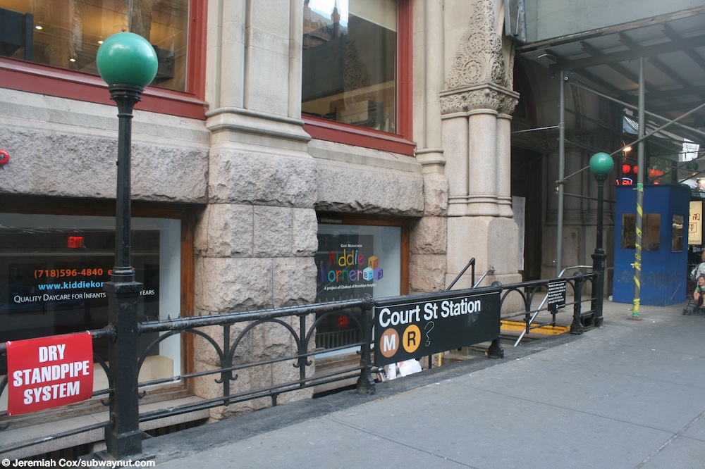
The unstaffed fare control area for the BMT Fourth Avenue Line is at the extreme west end. Outside fare control, two staircases go up to either western corner of Livingston and Court Streets.[46] The northwest staircase has an antique "SUBWAY" white and green globe sign since it is in the front yard of St. Ann's and Holy Trinity Church (the mezzanine has a mosaic sign with the church's name on it).[47] The southwest staircase is next to the basement entrance of a Kiddie Korner daycare.[46][48]
Station entrance at Columbus Park with view of Brooklyn Borough Hall, before the M train was rerouted

The street elevator only connects with the IRT Broadway–Seventh Avenue Line and the northbound platform of the IRT Eastern Parkway Line.
Another view of the elevator from the side
Entrance in front of Brooklyn Borough Hall

Former entrance to the Brooklyn Municipal Building


IRT Broadway–Seventh Avenue Line platforms[]
Borough Hall | |||
|---|---|---|---|
 Northbound R62 3 train arriving | |||
| Station statistics | |||
| Division | A (IRT)[49] | ||
| Line | IRT Broadway–Seventh Avenue Line | ||
| Services | 2 3 | ||
| Structure | Underground | ||
| Levels | 2 | ||
| Platforms | 2 side platforms (1 on each level) | ||
| Tracks | 2 (1 on each level) | ||
| Other information | |||
| Opened | April 15, 1919 | ||
| Station code | 335[3] | ||
| Accessible | |||
| Opposite- direction transfer | Yes | ||
| Station succession | |||
| Next north | Clark Street: 2 | ||
| Next south | Hoyt Street: 2 | ||
| |||
| |||

Borough Hall on the IRT Broadway–Seventh Avenue Line has two levels. Each level has one track with a side platform on the south side. Manhattan-bound trains use the upper level while southbound trains use the lower one.[50] The 2 train stops here at all times,[51] while the 3 train stops here at all times except late nights.[52] The IRT Broadway–Seventh Avenue Line platforms are connected by stairs, an escalator, and an elevator. At the eastern end of both platforms, a staircase from the lower level goes up to the upper level, near the passageway to the northbound IRT Eastern Parkway Line platform. At the western end of both platforms, a staircase from the lower level goes up to the upper level before another staircase goes up to a mezzanine. The lower level also has an up-only escalator that bypasses the upper level, leading directly to the mezzanine. A single elevator stops at all three levels.
At the eastern (railroad south) end of the platforms, the southbound track crosses under the tracks of the Eastern Parkway Line, and both tracks become the local tracks for the line.[50]
Design[]
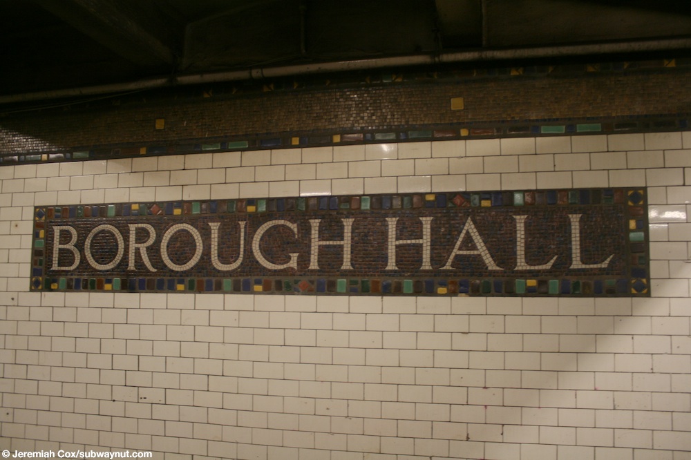
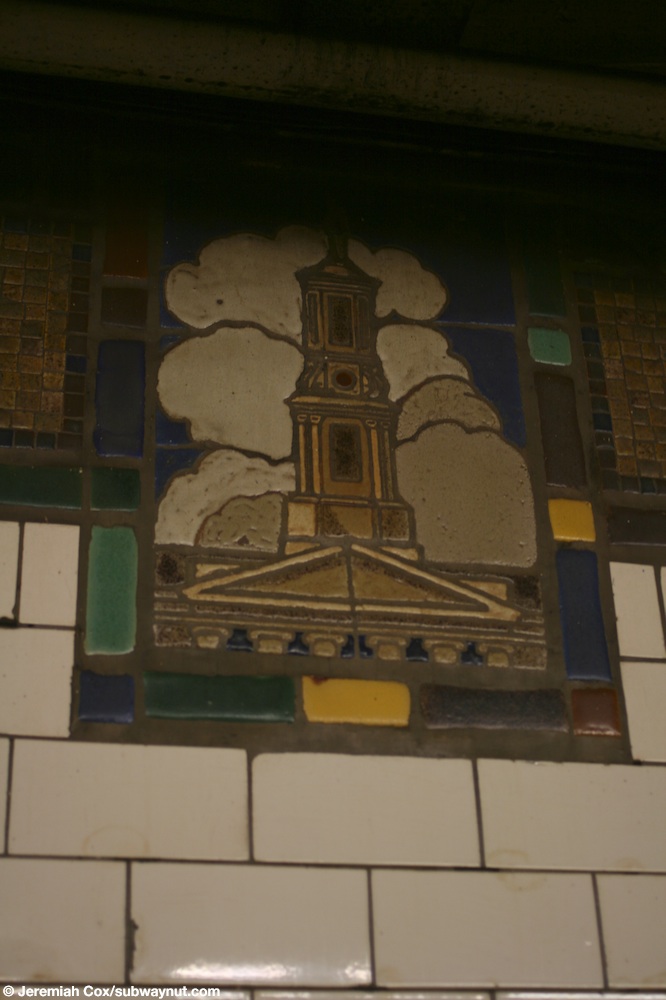
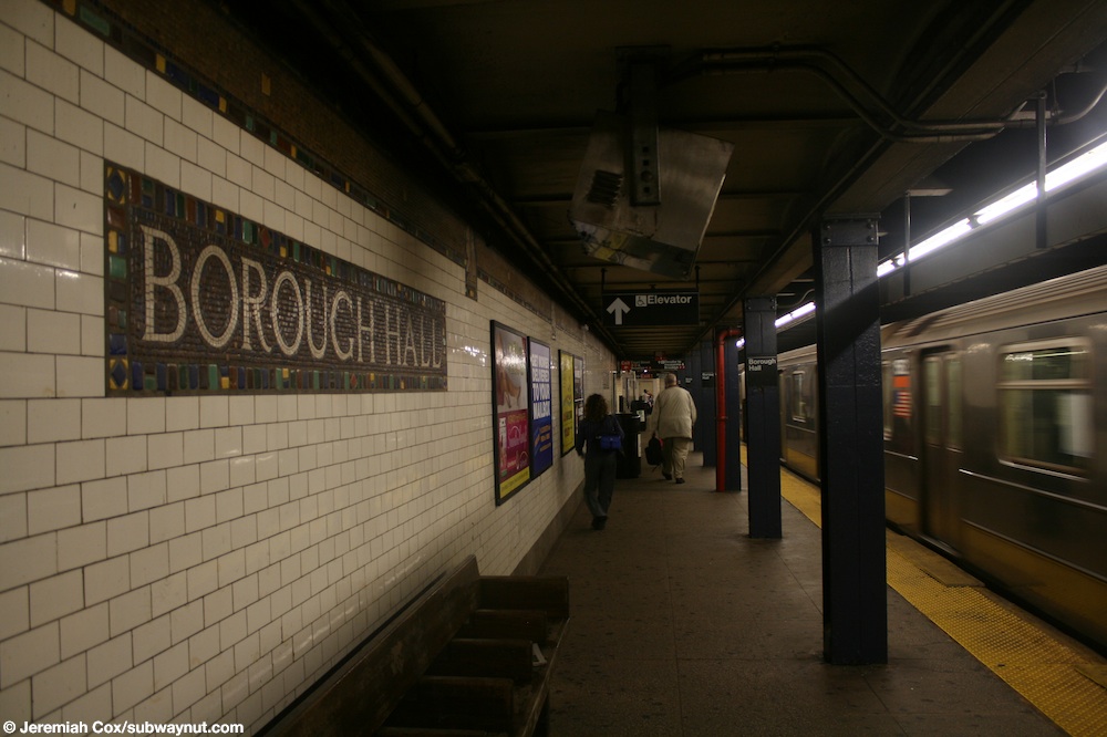
Both platforms have their original IRT trim line and name tablets reading "BOROUGH HALL" in a serif lettering style.[53] Tablets showing images of Borough Hall are located at regular intervals on the trim line.[54] Dark blue I-beam columns line both platforms at regular intervals with alternating ones having the standard black station name plate in white lettering.[55]
IRT Eastern Parkway Line platforms[]
Borough Hall | |||
|---|---|---|---|
 View from northbound platform | |||
| Station statistics | |||
| Division | A (IRT)[56] | ||
| Line | IRT Eastern Parkway Line | ||
| Services | 4 5 | ||
| Structure | Underground | ||
| Platforms | 2 side platforms | ||
| Tracks | 2 | ||
| Other information | |||
| Opened | January 9, 1908 | ||
| Station code | 415[3] | ||
| Accessible | |||
| Opposite- direction transfer | Yes | ||
| Station succession | |||
| Next north | Bowling Green: 4 | ||
| Next south | Nevins Street: 4 | ||
| |||
| |||
Borough Hall Subway Station (IRT) | |||
U.S. National Register of Historic Places | |||
New York City Landmark No. 1096 | |||
| MPS | New York City Subway System MPS | ||
| NRHP reference No. | 04001022[41] | ||
| NYCL No. | 1096 | ||
| Significant dates | |||
| Added to NRHP | September 17, 2004 | ||
| Designated NYCL | October 23, 1979[6] | ||
Borough Hall on the IRT Eastern Parkway Line has two tracks and two side platforms. The 4 train stops here at all times,[57] while the 5 train stops here at all times except late nights.[58] The platforms were originally 350 feet (110 m) long, as at other Contract 2 stations,[6]: 4 [41]: 3 but were lengthened to 520 feet (160 m) by 1964.[citation needed] Two staircases from each platform lead to each of the two overpasses at the center of the station, while one staircase from each platform leads to the overpass at the extreme west end.[41]: 6
In 1979, the New York City Landmarks Preservation Commission designated the space within the boundaries of the original station, excluding expansions made after 1904, as a city landmark. The station was designated along with eleven others on the original IRT.[6][59] The original interiors were listed on the National Register of Historic Places in 2004.[41]
East of this station, the two tracks become the express tracks of the IRT Eastern Parkway Line and the two tracks of the IRT Broadway–Seventh Avenue Line become the local tracks.[50]
Design[]

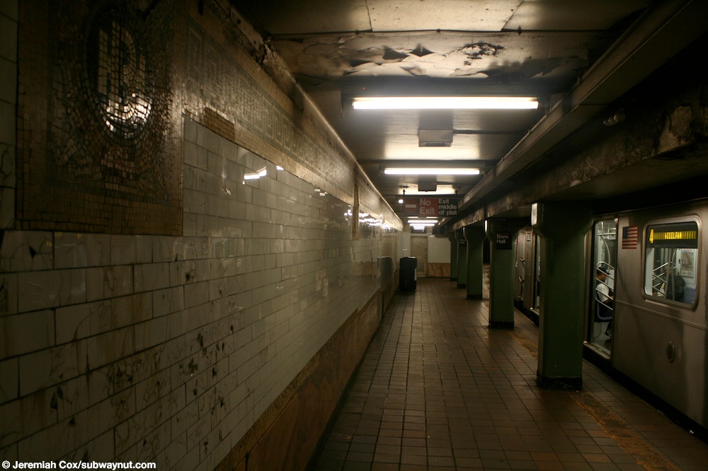
As with other stations built as part of the original IRT, the station was constructed using a cut-and-cover method.[9]: 237 The tunnel is covered by a "U"-shaped trough that contains utility pipes and wires. The bottom of this trough contains a foundation of concrete no less than 4 inches (100 mm) thick.[41]: 3–4 [60]: 9 Each platform consists of 3-inch-thick (7.6 cm) concrete slabs, beneath which are drainage basins.[41]: 3–4 [6]: 4 The platforms contain green I-beam columns,[61] spaced every 15 feet (4.6 m). Additional columns between the tracks, spaced every 5 feet (1.5 m), support the jack-arched concrete station roofs.[41]: 3–4 [6]: 4 [60]: 9 The ceiling height varies based on whether there are utilities in the ceiling.[41]: 5–6 There is a 1-inch (25 mm) gap between the trough wall and the platform walls, which are made of 4-inch (100 mm)-thick brick covered over by a tiled finish.[41]: 3–4 [60]: 9
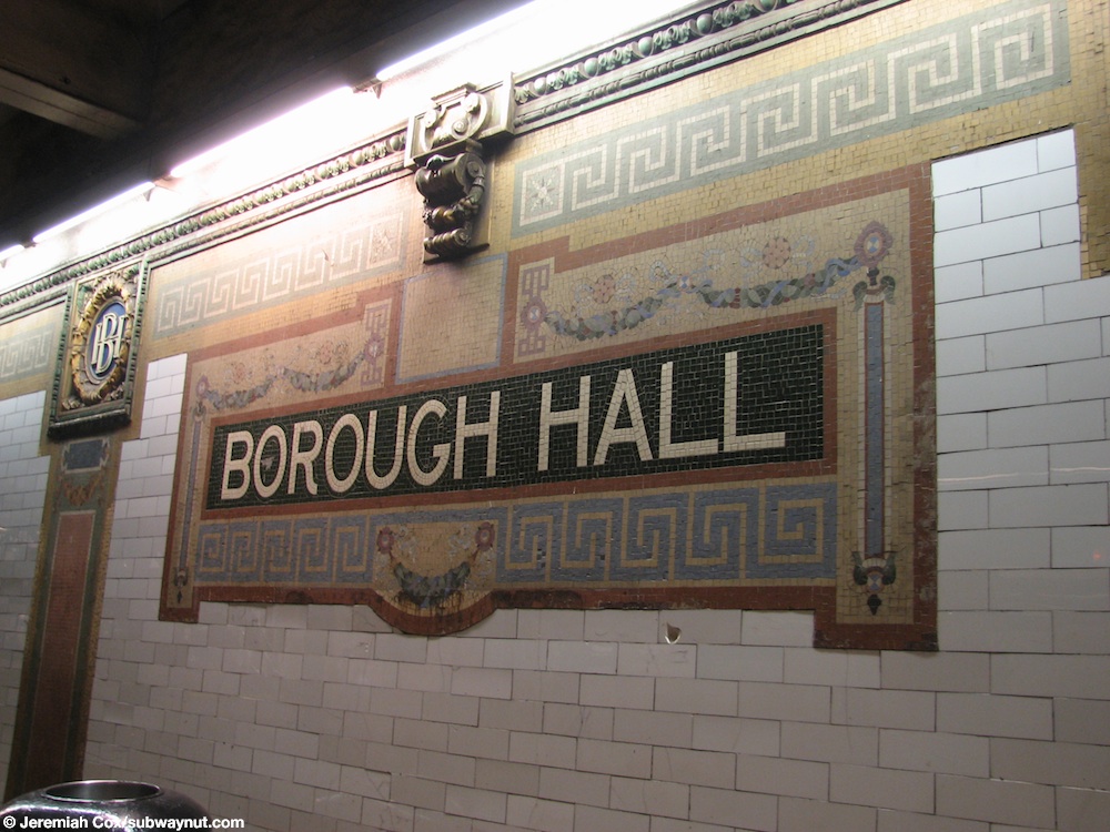
The walls along the platforms consist of a pink marble wainscoting on the lowest part of the wall, with bronze air vents along the wainscoting, and white glass tiles above. The platform walls are divided at 15-foot (4.6 m) intervals by green and rose pilasters, or vertical bands, with brown and buff-colored swags. In the original portion of the station, each pilaster is topped by blue, green, and yellow faience plaques with the letters "BH". White-on-green tile plaques with the words "Borough Hall", containing red, green, blue, buff, violet, and pink mosaic borders, are also placed on the walls.[41]: 5–6 [6]: 6–7 [62] The platform extensions contain similar decorative elements.[41]: 5 The ceilings contain plaster molding.[41]: 5 [60]: 10
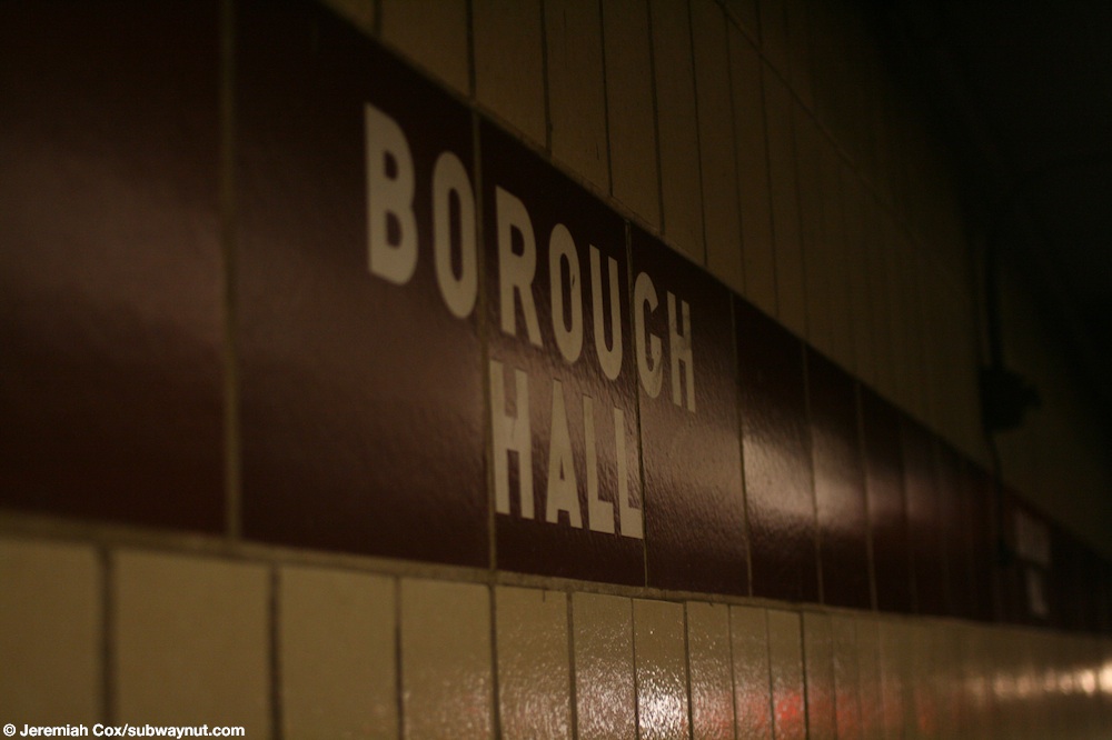
At the extreme east end of the platforms, where they were extended in the 1950s to accommodate the current standard "A" Division train length, there is a brown trim line on beige tiles with "BOROUGH HALL" in white sans serif lettering.[63]
BMT Fourth Avenue Line platform[]
Court Street | |||
|---|---|---|---|
 Platform view | |||
| Station statistics | |||
| Division | B (BMT)[64] | ||
| Line | BMT Fourth Avenue Line | ||
| Services | N R W | ||
| Structure | Underground | ||
| Platforms | 1 island platform | ||
| Tracks | 2 | ||
| Other information | |||
| Opened | August 1, 1920 | ||
| Station code | 024[3] | ||
| Accessible | |||
| Opposite- direction transfer | Yes | ||
| Station succession | |||
| Next north | Broad Street (Nassau Street): no regular service Whitehall Street–South Ferry (Broadway): N | ||
| Next south | Jay Street–MetroTech: N | ||
| |||
| |||
Court Street on the BMT Fourth Avenue Line has two tracks and one island platform.[50] The R stops here at all times;[65] some rush-hour W trains stop here;[66] and the N stops here during late nights.[67] A single staircase from the western end of the platform goes up to the elevators to the western BMT mezzanine. Two staircases from the eastern end of the platform go up to the escalators and stairs to the IRT passageway.
West of the station, the line goes through the Montague Street Tunnel under the East River to connect to the BMT Broadway Line and the BMT Nassau Street Line. All trains use the former connection;[50] the latter was last used by the M train in June 2010 before it was rerouted to run via the IND Sixth Avenue Line.[68][69]
Design[]
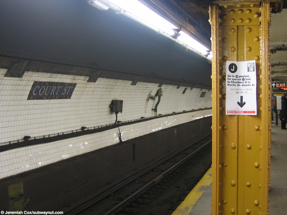
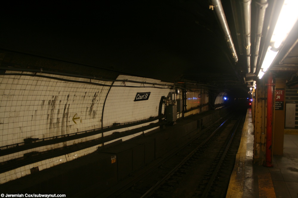
Since the tunnel descends to go underneath the East River, it was constructed with a deep-bore tunnel, making both track walls curved.[70] The walls also still have their original Dual Contracts mosaic tablets and trim line. The name tablets have "COURT ST." in serif lettering, and tablets showing scenes of Borough Hall are located along the trim line at regular intervals.[71] The western end (railroad north) of the walls is plain white.[72] Yellow I-beam columns line both sides of the island platform at regular intervals with alternating ones having the standard black station name plate in white lettering.[73] Some of these show the name "Carnegie", from Carnegie Steel (predecessor of United States Steel).[citation needed]
Image gallery[]
Mosaics on the track wall

An R46 R train leaving the station

An elevator to the Clinton Street mezzanine


Surface connections[]
In 1916, a single-track counterclockwise trolley loop was built around Borough Hall with both ends at Joralemon Street and access from westbound Fulton Street to the loop and from the loop to southbound Court Street.[citation needed] Passengers on lines that used the loop, Court Street, or Fulton Street could transfer to the entrance of this station complex bounded by those two streets and the loop, north of Borough Hall. The lines that used this loop included:[74]
- to Prospect Park
- to Greenwood Cemetery and the
- Hicks Street Line to Erie Basin
- to Flatbush
- St. Johns Place Line to Ocean Hill
- Third Avenue Line to Fort Hamilton
- to New Utrecht
There were other lines that passed Borough Hall and thus served the station. On Court Street, such lines included:
- to Gowanus
- Flatbush Avenue Line to Bergen Beach
- Greenpoint Line to Greenpoint (also on Joralemon Street)
- to
- to Greenwood Cemetery, , and Coney Island
On Fulton Street:
- DeKalb Avenue Line to Ridgewood
- Fulton Street Line to Cypress Hills
- Greene and Gates Avenues Line to Ridgewood
- Myrtle Avenue Line to Ridgewood
- Putnam Avenue Line to Ridgewood
On Joralemon Street:
- Crosstown Line to Erie Basin and Long Island City
- Erie Basin Line to Erie Basin
On April 7, 1930, the Brooklyn–Manhattan Transit Corporation eliminated the loop to relieve congestion.[75][76] Several lines were moved to a loop on Washington Street north of Tillary Street or a clockwise loop on Livingston Street, Court Street, Joralemon Street, Fulton Street, and Boerum Place.[citation needed]
References[]
- ^ "Glossary". Second Avenue Subway Supplemental Draft Environmental Impact Statement (SDEIS) (PDF). 1. Metropolitan Transportation Authority. March 4, 2003. pp. 1–2. Archived from the original (PDF) on February 26, 2021. Retrieved January 1, 2021.
- ^ Jump up to: a b "Transfer Points Under Higher Fare; Board of Transportation Lists Stations and Intersections for Combined Rides". The New York Times. June 30, 1948. p. 19. ISSN 0362-4331. Retrieved April 21, 2020.
- ^ Jump up to: a b c d "Station Developers' Information". Metropolitan Transportation Authority. Retrieved June 13, 2017.
- ^ "Facts and Figures: Annual Subway Ridership 2014–2019". Metropolitan Transportation Authority. 2020. Retrieved May 26, 2020.
- ^ Jump up to: a b c d e Walker, James Blaine (1918). Fifty Years of Rapid Transit — 1864 to 1917. New York, N.Y.: Law Printing. Retrieved November 6, 2016.
- ^ Jump up to: a b c d e f g h "Interborough Rapid Transit System, Underground Interior" (PDF). New York City Landmarks Preservation Commission. October 23, 1979. Retrieved November 19, 2019.
- ^ Report of the Board of Rapid Transit Railroad Commissioners for the City of New York For The Year Ending December 31, 1904 Accompanied By Reports of the Chief Engineer and of the Auditor. Board of Rapid Transit Railroad Commissioners. 1905. pp. 229–236.
- ^ Report of the Board of Rapid Transit Railroad Commissioners For And In The City of New York Up to December 31, 1901. Board of Rapid Transit Railroad Commissioners. 1902.
- ^ Jump up to: a b Scott, Charles (1978). "Design and Construction of the IRT: Civil Engineering" (PDF). Historic American Engineering Record. pp. 208–282 (PDF pp. 209–283). Retrieved December 20, 2020.
 This article incorporates text from this source, which is in the public domain.CS1 maint: postscript (link)
- ^ "Statistics of East River Tunnel". The Brooklyn Daily Eagle. January 9, 1908. p. 26. Retrieved January 1, 2021 – via newspapers.com
 .
.
- ^ "Construction of the Tunnel Presented Difficult Problems". The Brooklyn Daily Eagle. January 9, 1908. pp. 26, 27 – via Brooklyn Public Library; newspapers.com .
- ^ "Brooklyn Joyful Over Its Tunnel". The New York Times. January 10, 1908. Retrieved March 6, 2010.
- ^ Report of the Public Service Commission For The First District of the State of New York For The Year Ending December 31, 1908. New York State Public Service Commission. 1908.
- ^ "Brooklyn Joyful Over New Subway; Celebrates Opening of Extension With Big Parade and a Flow of Oratory". The New York Times. May 2, 1908. ISSN 0362-4331. Retrieved January 5, 2021.
- ^ The Merchants' Association of New York Pocket Guide to New York. Merchants' Association of New York. March 1906. pp. 19–26.
- ^ "Tunnel to Brooklyn to Open Next Week; Subway Extension Under East River May Begin Carrying Passengers on Thursday" (PDF). The New York Times. January 4, 1908. p. 1. ISSN 0362-4331. Retrieved January 5, 2021.
- ^ Jump up to: a b Hood, Clifton (1978). "The Impact of the IRT in New York City" (PDF). Historic American Engineering Record. pp. 146–207 (PDF pp. 147–208). Retrieved December 20, 2020. This article incorporates text from this source, which is in the public domain.CS1 maint: postscript (link)
- ^ Jump up to: a b Report of the Public Service Commission for the First District of the State of New York For The Year Ending December 31, 1910. Public Service Commission. 1911.
- ^ "Ten-car Trains in Subway to-day; New Service Begins on Lenox Av. Line and Will Be Extended to Broadway To-morrow". The New York Times. January 23, 1911. ISSN 0362-4331. Retrieved April 5, 2018.
- ^ "MONEY SET ASIDE FOR NEW SUBWAYS; Board of Estimate Approves City Contracts to be Signed To-day with Interboro and B.R.T." (PDF). The New York Times. March 19, 1913. ISSN 0362-4331. Retrieved November 10, 2017.
- ^ Whitney, Travis H. (March 10, 1918). "The Seventh and Lexington Avenue Subways Will Revive Dormant Sections — Change in Operation That Will Transform Original Four-Tracked Subway Into Two Four-Tracked Systems and Double Present Capacity of the Interborough" (PDF). The New York Times. p. 12. ISSN 0362-4331. Retrieved August 26, 2016.
- ^ "Public Service Commission Fixes July 15 For Opening of The New Seventh and Lexington Avenue Subway Lines — Will Afford Better Service and Less Crowding — Shuttle Service for Forty-Second Street — How the Various Lines of the Dual System Are Grouped for Operation and List of Stations on All Lines" (PDF). The New York Times. May 19, 1918. p. 32. ISSN 0362-4331. Retrieved November 6, 2016.
- ^ "Work Begins on New Tubes Under River — Engineer Tells How Subway Tunnels Will Be Cut Through to Brooklyn — Will Burrow in Shield — Steel Ring Pushed Forward Under Hydraulic Pressure of 6,000,000 Pounds". The New York Times. October 11, 1914. p. 2. ISSN 0362-4331. Retrieved February 28, 2010.
- ^ "Open New Subway Lines to Traffic; Called a Triumph — Great H System Put in Operation Marks an Era in Railroad Construction — No Hitch in the Plans — But Public Gropes Blindly to Find the Way in Maze of New Stations — Thousands Go Astray — Leaders in City's Life Hail Accomplishment of Great Task at Meeting at the Astor" (PDF). The New York Times. August 2, 1918. p. 1. Retrieved November 6, 2016.
- ^ "Open Clark Street Line — New Route Doubles Subway Service Between the Two Boroughs" (PDF). The New York Times. April 16, 1919. p. 18. Retrieved November 6, 2016.
- ^ 1920-1921 Annual Report of the Interborough Rapid Transit Company For The Year Ended June 30, 1921. Interborough Rapid Transit Company. 1921. p. 10.
- ^ "More Interborough Service for Brooklyn 2 New Lines". pudl.princeton.edu. Interborough Rapid Transit Company. August 23, 1920. Retrieved September 19, 2016.
- ^ "Brooklyn Tube Extensions Open: I.R.T. Begins Service on Eastern Parkway and Nostrand Avenue Lines" (PDF). New York Times. August 23, 1920. Retrieved December 20, 2015.
- ^ Fourth Avenue Subway, Brooklyn's New Transportation Line: A Part of the Dual System of Rapid Transit of the City of New York. New York State Public Service Commission. June 19, 1915.
- ^ "Work Begins on New Tubes Under River". The New York Times. October 11, 1914. Retrieved February 28, 2010.
- ^ "Two River Tunnels Opened 90 Years Ago". The Bulletin. New York Division, Electric Railroaders' Association. 53 (8). August 2010. Retrieved August 26, 2016 – via Issuu.
- ^ District, New York (State) Public Service Commission First (January 1, 1921). Annual Report for the Year Ended ... The Commission.
- ^ Brennan, Joseph (January 1996). "www.nycsubway.org: Brooklyn IRT Map - Contract 2 Construction". www.nycsubway.org. Retrieved August 6, 2017.
- ^ Jump up to: a b Burks, Edward C. (November 18, 1976). "A Subway Elongatomus? Why, It's Preposterous!". The New York Times. Retrieved September 21, 2016.
- ^ McGeehan, Patrick (September 12, 2014). "Subway Tunnel to Open, Storm Repairs Finished". The New York Times. Retrieved September 13, 2014.
- ^ Newman, Andy; Goodman, J. David (September 15, 2014). "The R Roars Back". The New York Times. Retrieved October 30, 2016.
- ^ "R Montague Tunnel Closure Map" (PDF). mta.info. Metropolitan Transportation Authority. June 2013. Archived from the original on June 16, 2013. Retrieved October 30, 2016.CS1 maint: bot: original URL status unknown (link)
- ^ "mta.info - R Service affected by 14 month closure of Montague Under River Tube". mta.info. Metropolitan Transportation Authority. July 2013. Archived from the original on June 9, 2013. Retrieved October 30, 2016.CS1 maint: bot: original URL status unknown (link)
- ^ Flegenheimer, Matt (August 4, 2013). "On R Train, Unwelcome Reminder of Storm's Impact". The New York Times. ISSN 0362-4331. Retrieved July 26, 2017.
- ^ Jump up to: a b "MTA Inspector General: Brooklyn Borough Hall Ceiling Collapse Could Have Been Avoided". Archived from the original on November 20, 2019. Retrieved November 21, 2019.
- ^ Jump up to: a b c d e f g h i j k l m n o p q r s "New York MPS Borough Hall Subway Station (IRT)". Records of the National Park Service, 1785 - 2006, Series: National Register of Historic Places and National Historic Landmarks Program Records, 2013 - 2017, Box: National Register of Historic Places and National Historic Landmarks Program Records: New York, ID: 75313349. National Archives.
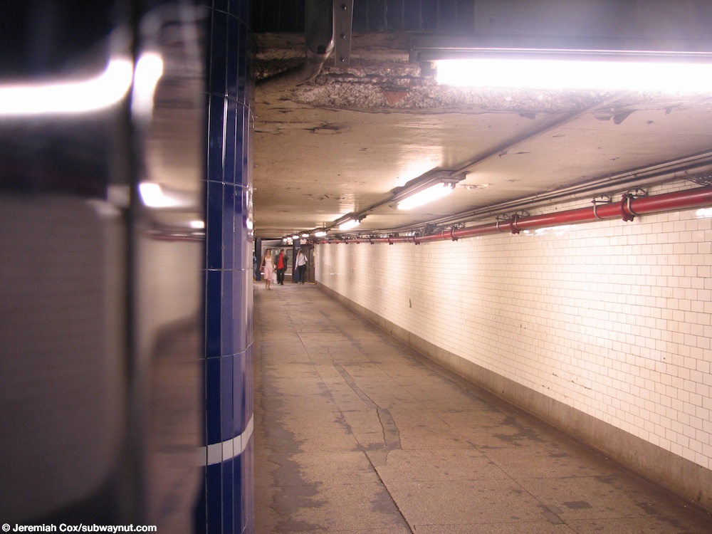
- ^ Cox, Jeremiah (May 12, 2007). "Looking down the passageway between the Manhattan-bound 2,3 and 4,5 platforms at Borough Hall". subwaynut.com. Retrieved August 6, 2017.
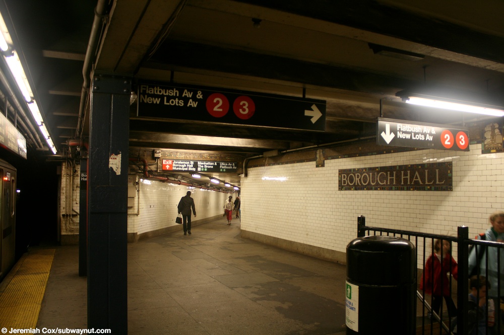
- ^ Cox, Jeremiah (June 18, 2009). "The back of the Manhattan-bound platform at Borough Hall, the passageway to the East Side 4,5 Line is visible up-ahead, one of the two staircases down to the Flatbush & New Lots 2,3 platform is down below". subwaynut.com. Retrieved August 6, 2017.
- ^ "Accessibility". web.mta.info. Metropolitan Transportation Authority. Retrieved August 6, 2017.
- ^ mtainfo (February 6, 2019). NYCT Public Event - Discussion About the Next Accessible Subway Stations - 02/06/2019 (video) – via YouTube.
- ^ Jump up to: a b c d e f "MTA Neighborhood Maps: Downtown Brooklyn and Borough Hall" (PDF). mta.info. Metropolitan Transportation Authority. 2015. Retrieved August 2, 2015.
- ^ Cox, Jeremiah (July 6, 2009). "One of the entrance staircases to Court Street, it is extremely unusual, in front of St. Ann's and the Holy Trinity Church". subwaynut.com. Retrieved August 6, 2017.
- ^ Cox, Jeremiah (July 6, 2009). "Another unusual entrance staircase to the Clinton Street exit at Court Street". subwaynut.com. Retrieved August 6, 2017.
- ^ "Glossary". Second Avenue Subway Supplemental Draft Environmental Impact Statement (SDEIS) (PDF). 1. Metropolitan Transportation Authority. March 4, 2003. pp. 1–2. Archived from the original (PDF) on February 26, 2021. Retrieved January 1, 2021.
- ^ Jump up to: a b c d e Dougherty, Peter (2006) [2002]. Tracks of the New York City Subway 2006 (3rd ed.). Dougherty. OCLC 49777633 – via Google Books.
- ^ "2 Subway Timetable, Effective September 13, 2020". Metropolitan Transportation Authority. Retrieved December 9, 2020.
- ^ "3 Subway Timetable, Effective September 13, 2020". Metropolitan Transportation Authority. Retrieved December 9, 2020.
- ^ Cox, Jeremiah (June 18, 2009). "A Borough Hall name tablet, it has a fairly colorful border". subwaynut.com. Retrieved August 6, 2017.
- ^ Cox, Jeremiah (June 28, 2008). "A close-up of an intricate Vickers dual-contracts era representation of a Brooklyn Building that is the trimline for the platform trim line at Borough Hall". subwaynut.com. Retrieved August 6, 2017.
- ^ Cox, Jeremiah (June 18, 2009). "Looking down the Manhattan-bound platform at Borough Hall, by a name tablet". subwaynut.com. Retrieved August 6, 2017.
- ^ "Glossary". Second Avenue Subway Supplemental Draft Environmental Impact Statement (SDEIS) (PDF). 1. Metropolitan Transportation Authority. March 4, 2003. pp. 1–2. Archived from the original (PDF) on February 26, 2021. Retrieved January 1, 2021.
- ^ "4 Subway Timetable, Effective September 13, 2020". Metropolitan Transportation Authority. Retrieved December 9, 2020.
- ^ "5 Subway Timetable, Effective September 13, 2020". Metropolitan Transportation Authority. Retrieved December 9, 2020.
- ^ "12 IRT Subway Stops Get Landmark Status". The New York Times. October 27, 1979. ISSN 0362-4331. Retrieved December 26, 2020.
- ^ Jump up to: a b c d Framberger, David J. (1978). "Architectural Designs for New York's First Subway" (PDF). Historic American Engineering Record. pp. 1-46 (PDF pp. 367-412). Retrieved December 20, 2020. This article incorporates text from this source, which is in the public domain.CS1 maint: postscript (link)
- ^ Cox, Jeremiah (June 18, 2009). "Another view down the Manhattan-bound side platform at Borough Hall with its green columns and a Woodlawn-bound R142 4 train stopped in the station". subwaynut.com. Retrieved August 6, 2017.
- ^ Cox, Jeremiah (May 12, 2007). "A mosaic Borough Hall name tablet, there is a decorative terra-cotta wall reliefs above it". subwaynut.com. Retrieved August 6, 2017.
- ^ Cox, Jeremiah (June 9, 2008). "Painted on Borough Hall text in the 1950s tiled portion of the extreme eastern (southern) end of the station at Borough Hall". subwaynut.com. Retrieved August 6, 2017.
- ^ "Glossary". Second Avenue Subway Supplemental Draft Environmental Impact Statement (SDEIS) (PDF). 1. Metropolitan Transportation Authority. March 4, 2003. pp. 1–2. Archived from the original (PDF) on February 26, 2021. Retrieved January 1, 2021.
- ^ "R Subway Timetable, Effective November 8, 2020" (PDF). Metropolitan Transportation Authority. Retrieved December 9, 2020.
- ^ "W Subway Timetable, Effective November 8, 2020" (PDF). Metropolitan Transportation Authority. Retrieved December 9, 2020.
- ^ "N Subway Timetable, Effective November 8, 2020" (PDF). Metropolitan Transportation Authority. Retrieved December 9, 2020.
- ^ "Major Subway Changes Set for Monday". mta.info. Metropolitan Transportation Authority. June 24, 2010. Archived from the original on December 28, 2015. Retrieved October 20, 2016.
- ^ "Evaluation of 2010 Service Reductions" (PDF). mta.info. Metropolitan Transportation Authority. September 23, 2011. Archived (PDF) from the original on December 8, 2015. Retrieved October 20, 2016.
- ^ Cox, Jeremiah (January 15, 2005). "Looking out along one of the tracks at Court Street, at a name tablet on the track walls, there is also a sign on a platform column saying that special J trains stop at this platform that are replacing 4 train service between Brooklyn Bridge and Brooklyn". subwaynut.com. Retrieved August 6, 2017.
- ^ Cox, Jeremiah (July 6, 2009). "The tiling of the platform walls at Court Street are extremely decorative and colorful, with rainbow colored borders around the name tablets and trim-lines". subwaynut.com. Retrieved August 6, 2017.
- ^ Cox, Jeremiah (July 6, 2009). "Approaching the northern (western) end of the platform at Court Street, the walls become single white tiles with simple station name signs". subwaynut.com. Retrieved August 6, 2017.
- ^ Cox, Jeremiah (April 2, 2006). "Looking down the single island platform at Court Street towards a staircase up to the small lower-mezzanine landing that leads up to the escalators and the IRT transfer". subwaynut.com. Retrieved August 6, 2017.
- ^ Brooklyn Daily Eagle Almanac. The Brooklyn Daily Eagle. 1916.
- ^ The New York Times, Reroute Cars to Aid Brooklyn Traffic, April 1, 1930, page 14
- ^ The New York Times, Brooklyn Accepts New Traffic Rules, April 8, 1930, page 24
Further reading[]
- Lee Stokey. Subway Ceramics: A History and Iconography. 1994. ISBN 978-0-9635486-1-0.
External links[]
| Wikimedia Commons has media related to Court Street – Borough Hall (New York City Subway). |
- nycsubway.org – Brooklyn IRT: Borough Hall (West Side Branch)
- nycsubway.org – Brooklyn IRT: Borough Hall (East Side Branch)
- nycsubway.org – BMT Broadway Subway: Court Street
- nycsubway.org – Brooklyn IRT Contract 2 map: Map 1 (includes current and former track configurations, and provisions for future connections)
| show Stations of the New York City Subway, by service |
|---|
| show Stations of the New York City Subway, by line (physical trackage) |
|---|
| show U.S. National Register of Historic Places in New York |
|---|

- Accessible New York City Subway stations
- Future accessible New York City Subway stations
- IRT Broadway–Seventh Avenue Line stations
- IRT Eastern Parkway Line stations
- BMT Fourth Avenue Line stations
- New York City Subway transfer stations
- Railway and subway stations on the National Register of Historic Places in New York City
- New York City Subway stations in Brooklyn
- Railway stations in the United States opened in 1920
- 1920 establishments in New York (state)
- Downtown Brooklyn
- Brooklyn Heights
- National Register of Historic Places in Brooklyn
- New York City Subway stations located underground