59th Street–Columbus Circle station
59 Street–Columbus Circle | |||
|---|---|---|---|
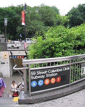 Station entrance north of Columbus Circle | |||
| Station statistics | |||
| Address | Intersection of West 59th Street, Eighth Avenue & Broadway New York, NY 10023[1] | ||
| Borough | Manhattan | ||
| Locale | Columbus Circle, Midtown Manhattan | ||
| Coordinates | 40°46′05″N 73°58′55″W / 40.767997°N 73.981934°WCoordinates: 40°46′05″N 73°58′55″W / 40.767997°N 73.981934°W | ||
| Division | A (IRT), B (IND)[2] | ||
| Line | IND Eighth Avenue Line IRT Broadway–Seventh Avenue Line | ||
| Services | 1 2 A B C D | ||
| Transit | |||
| Levels | 2 | ||
| Other information | |||
| Opened | July 1, 1948[3] | ||
| Station code | 614[4] | ||
| Accessible | |||
| Traffic | |||
| 2019 | 23,040,650[6] | ||
| Rank | 8 out of 424[6] | ||
| |||
| |||
| |||


59th Street–Columbus Circle is a New York City Subway station complex shared by the IRT Broadway–Seventh Avenue Line and the IND Eighth Avenue Line. It is the eighth-busiest station complex in the system.[5] It is located at Columbus Circle in Manhattan, where 59th Street, Broadway and Eighth Avenue intersect, and serves Central Park, the Upper West Side, Hell's Kitchen, and Midtown Manhattan. The station is served by the 1, A, and D trains at all times; the C train at all times except late nights; the B train during weekdays until 11:00 p.m.; and the 2 train during late nights.
The Broadway–Seventh Avenue Line station was built for the Interborough Rapid Transit Company (IRT), and was a local station on the city's first subway line, which was approved in 1900. The station opened on October 27, 1904, as one of the original 28 stations of the New York City Subway. The Eighth Avenue Line station was built as an express station for the Independent Subway System (IND) and opened on September 10, 1932, as part of the IND's first segment. The complex was renovated in the 2000s.
The IRT station has two side platforms and four tracks; express trains use the inner two tracks to bypass the station. The IND station has three island platforms and four tracks, but only two of the platforms are in use. The transfer between the IRT platforms and the IND platforms has been within fare control since July 1, 1948. The station complex contains elevators, which make it compliant with the Americans with Disabilities Act of 1990. The original portion of the IRT station's interior is a New York City designated landmark and listed on the National Register of Historic Places.
History[]
The IRT Broadway–Seventh Avenue Line and IND Eighth Avenue Line stations are connected by passageways, which were placed inside fare control on July 1, 1948.[7]
In 2002, as part of the construction of the nearby Hearst Tower, a renovation of the station complex was proposed. This project added elevators and improved circulation at the congested station.[8] When work started in 2006, the project was expected to cost $108 million.[9] After the project was completed in 2012, parts of the complex were converted to retail space.[10]
IRT Broadway–Seventh Avenue Line[]
Construction and opening[]
Planning for a subway line in New York City dates to 1864.[11]: 21 However, development of what would become the city's first subway line did not start until 1894, when the New York State Legislature authorized the Rapid Transit Act.[11]: 139–140 The subway plans were drawn up by a team of engineers led by William Barclay Parsons, chief engineer of the Rapid Transit Commission. It called for a subway line from New York City Hall in lower Manhattan to the Upper West Side, where two branches would lead north into the Bronx.[12]: 3 A plan was formally adopted in 1897,[11]: 148 and all legal conflicts concerning the route alignment were resolved near the end of 1899.[11]: 161 The Rapid Transit Construction Company, organized by John B. McDonald and funded by August Belmont Jr., signed the initial Contract 1 with the Rapid Transit Commission in February 1900,[13] in which it would construct the subway and maintain a 50-year operating lease from the opening of the line.[11]: 165 In 1901, the firm of Heins & LaFarge was hired to design the underground stations.[12]: 4 Belmont incorporated the Interborough Rapid Transit Company (IRT) in April 1902 to operate the subway.[11]: 182
The 59th Street station was constructed as part of the IRT's West Side Line (now the Broadway–Seventh Avenue Line) from 60th Street to 82nd Street, for which work had begun on August 22, 1900. These sections had been awarded to William Bradley.[13]
The 59th Street station opened on October 27, 1904, as one of the original 28 stations of the New York City Subway from City Hall to 145th Street on the West Side Branch.[14][11]: 186 The opening of the first subway line, and particularly the 59th Street station, helped contribute to the development of Columbus Circle and the Upper West Side.[15]: 9 After the first subway line was completed in 1908,[16] the station was served by local trains along both the West Side (now the Broadway–Seventh Avenue Line to Van Cortlandt Park–242nd Street) and East Side (now the Lenox Avenue Line). Local trains ran from City Hall to 242nd Street in the Bronx during rush hours, continuing south from City Hall to South Ferry at other times. East side local trains ran from City Hall to Lenox Avenue (145th Street).[17] In 1918, the Broadway–Seventh Avenue Line opened south of Times Square–42nd Street, thereby dividing the original line into an "H"-shaped system. The original subway north of Times Square thus became part of the Broadway–Seventh Avenue Line, and all local trains were sent to South Ferry.[18]
Later years[]
To address overcrowding, in 1909, the New York Public Service Commission proposed lengthening platforms at stations along the original IRT subway.[19]: 168 As part of a modification to the IRT's construction contracts, made on January 18, 1910, the company was to lengthen station platforms to accommodate ten-car express and six-car local trains. In addition to $1.5 million (equivalent to $41.7 million in 2020) spent on platform lengthening, $500,000 (equivalent to $13,888,000 in 2020) was spent on building additional entrances and exits. It was anticipated that these improvements would increase capacity by 25 percent.[20]: 15 Platforms at local stations, such as the 59th Street–Columbus Circle station, were lengthened by between 20 to 30 feet (6.1 to 9.1 m). The northbound platform was extended to the south, while the southbound platform was extended to the north and south.[20]: 110
The IRT station was constructed as a local stop prior to the IND's construction. As a result, during the early 1950s, the New York City Transit Authority (NYCTA; now an agency of the Metropolitan Transportation Authority, or MTA) considered converting the 59th Street–Columbus Circle station, a major transfer point to the IND Eighth Avenue Line, from a local stop to an express stop. This would serve the anticipated rise of ridership at the stop resulting from the under-construction New York Coliseum and the expected redevelopment of the area. In conjunction with that project, the NYCTA considered converting the to a local station by walling off the express tracks from the platforms.[21] While the work was never completed, the firm Edwards, Kelcey and Beck was hired as Consulting Engineers in 1955 for the construction of the express station.[22]

The IRT routes were given numbered designations with the introduction of "R-type" rolling stock, which contained rollsigns with numbered designations for each service. The first such fleet, the R12, was put into service in 1948.[23] The Broadway route to 242nd Street became known as the 1 and the Lenox Avenue route as the 3.[24] In 1959, all 1 trains became local and all 3 trains became express.[25]
In 1979, the New York City Landmarks Preservation Commission designated the space within the boundaries of the original IRT station, excluding expansions made after 1904, as a city landmark. The station was designated along with eleven others on the original IRT.[12][26]
In April 1988,[27] the New York City Transit Authority (NYCTA) unveiled plans to speed up service on the Broadway–Seventh Avenue Line through the implementation of a skip-stop service: the 9 train.[28] When skip-stop service started in 1989, it was only implemented north of 137th Street–City College on weekdays, and 59th Street was served by both the 1 and the 9.[29][30][31]
The IRT station's original interiors were listed on the National Register of Historic Places in 2004.[15] Skip-stop service ended on May 27, 2005.[32][33]
IND Eighth Avenue Line[]
The Eighth Avenue Line station opened on September 10, 1932, as part of the city-operated Independent Subway System (IND)'s initial segment, the Eighth Avenue Line between Chambers Street and 207th Street.[34] When the Eighth Avenue Line was being built, the station was originally planned to be located at 57th Street, with entrances extending up to 61st Street. The IND and IRT stations were designed as a major transit hub under Columbus Circle.[35]
The center platform between the IND's express tracks was originally built along with the other platforms, but was first used in passenger service in 1959. It served the purpose of a Spanish solution, allowing passengers to exit both sides of subway cars as the express trains would open the doors on both sides. Newer subway cars' door controls made it more difficult to open doors on both sides of the train simultaneously; thus this solution became impractical and the platform was closed on November 8, 1973. In 2007–2010, it was converted to a crossunder between the IRT side platforms. Large metal fences have been erected to keep people away from the edges.
Station layout[]
| G | Street level | Exits/entrances |
| B1 | Mezzanine | Fare control, station agent, MetroCard vending machines Shops, to exits |
| Side platform | ||
| Northbound local | ← ← | |
| Northbound express | ← | |
| Southbound express | | |
| Southbound local | | |
| Side platform | ||
| B2 | IND mezzanine | Transfers between lines and platforms |
| B3 | Northbound local | ← ← ← |
| Island platform | ||
| Northbound express | ← ← | |
| Island platform, not in service, used as passageway between IRT Broadway–Seventh Avenue Line platforms | ||
| Southbound express | | |
| Island platform | ||
| Southbound local | | |
Entrances and exits[]

This station complex has many entrances/exits from the streets. The one at the north end of Columbus Circle leads to the Trump International Hotel and Tower. It has a double wide staircase going down to an intermediate level before another double-wide staircase goes down to fare control, where a now unused token booth and turnstile bank lead to the IND mezzanine as well as the north end of the northbound IRT platform. There is also one elevator from the back of the staircase that goes down to fare control.[36]
Two staircases from the northwest corner of Broadway and West 60th Street go down to an unstaffed fare control area, where three full height turnstiles and a short staircase provide direct access to the north end of the southbound IRT platform. Another staircase at the southern median of the same intersection go down to a bank of turnstiles leading to the center of the same platform.[36]
The Time Warner Center at the northwest corner of West 58th Street and Eighth Avenue has a set of elevators, escalators, and staircases going down to fare control, where a token booth and turnstile bank provide entrance/exit to the station. A single staircase goes down to each IND platform at their extreme south end while a passageway leads to the southbound IRT platform. The mezzanine also has a staircase going up to the northeast corner of West 58th Street and Eighth Avenue. There is a passageway leading to another staircase that goes up to the northwest corner of West 57th Street and Eighth Avenue, as well as staircases within the Hearst Tower to the southwest corner of that intersection.[36] A complex of restaurants and shops called "Turnstyle" opened in this passageway in April 2016.[37]
The south end of the northbound IRT platform has a same-level unstaffed fare control area containing full height turnstiles and two staircases that ascend to the southeastern corner of Central Park South and Broadway, just outside 240 Central Park South.[36]
In October 1992, at a public hearing, New York City Transit proposed closing street staircase S6 to the northwest corner of 61st Street and Central Park West (outside what is now 15 Central Park West) and reopening street staircase S2 at 60th Street and Central Park West, located to the east of the circular stair, in order to expand the Transit Police District Command to accommodate more officers and increase the efficiency of the operation. The circular staircase was expected to be reconstructed to provide more direct access. The 61st Street exit was operated part-time, closing at nights, consisted of a high exit turnstile and was used by 2400 daily passengers. It was located in a remote unmonitored portion of the station, making safety an added consideration for its closure. Four staircases to the two platforms that led to the passageway leading to the exit were removed.[38][39]
IRT Broadway–Seventh Avenue Line platforms[]
59 Street–Columbus Circle | |||
|---|---|---|---|
 Uptown platform | |||
| Station statistics | |||
| Division | A (IRT)[40] | ||
| Line | IRT Broadway–Seventh Avenue Line | ||
| Services | 1 2 | ||
| Structure | Underground | ||
| Platforms | 2 side platforms | ||
| Tracks | 4 | ||
| Other information | |||
| Opened | October 27, 1904[14] | ||
| Station code | 315[4] | ||
| Accessible | |||
| Opposite- direction transfer | Yes | ||
| Station succession | |||
| Next north | 66th Street–Lincoln Center: 1 | ||
| Next south | 50th Street: 1 | ||
| |||
| |||
59th Street – Columbus Circle (IRT) | |||
U.S. National Register of Historic Places | |||
New York City Landmark No. 1096 | |||
| MPS | New York City Subway System MPS | ||
| NRHP reference No. | 04001015[15] | ||
| NYCL No. | 1096 | ||
| Significant dates | |||
| Added to NRHP | September 17, 2004 | ||
| Designated NYCL | October 23, 1979[12] | ||
59th Street–Columbus Circle on the IRT Broadway–Seventh Avenue Line has four tracks and two side platforms. The two express tracks are used by the 2 train during daytime hours and the 3 train at all times.[41] The platforms were originally 200 feet (61 m) long, as at other local stations on the original IRT,[15]: 3 [12]: 4 [42]: 8 but as a result of the 1958–1959 platform extension, became 520 feet (160 m) long.[43]
Design[]
As with other stations built as part of the original IRT, the station was constructed using a cut-and-cover method.[44]: 237 The tunnel is covered by a "U"-shaped trough that contains utility pipes and wires. The bottom of this trough contains a foundation of concrete no less than 4 inches (100 mm) thick.[15]: 3–4 [42]: 9 Each platform consists of 3-inch-thick (7.6 cm) concrete slabs, beneath which are drainage basins. The original platforms contain circular, cast-iron Doric-style columns spaced every 15 feet (4.6 m), while the platform extensions contain I-beam columns. Additional columns between the tracks, spaced every 5 feet (1.5 m), support the jack-arched concrete station roofs.[15]: 3–4 [12]: 4 [42]: 9 The ceiling height varies based on whether there are utilities in the ceiling; the areas without utilities are about 15 feet (4.6 m) above platform level. There is a 1-inch (25 mm) gap between the trough wall and the platform walls, which are made of 4-inch (100 mm)-thick brick covered over by a tiled finish.[15]: 3–4 [42]: 9
There are fare control areas at platform level, and both platforms are adjacent to mezzanines connecting to the IND part of the station.[15]: 4 The walls along the southbound platform and a short stretch of the northbound platform consist of a brick wainscoting on the lowest part of the wall and white glass tiles above, while the rest of the nortbound platform has ceramic tile walls. The platform walls are divided at 15-foot (4.6 m) intervals by green and red tile pilasters, or vertical bands. Atop each pilaster are faience plaques in blue, green, brown, and cream, with motifs depicting the Santa María, one of Christopher Columbus's ships. The walls contain two varieties of mosaic tile plaques, with the name "Columbus Circle" in white letters, alternating with each other. One variety of name plaques contains a green-mosaic background, while the other has a green faience background with half-circle motifs and Renaissance style moldings.[15]: 4 [12]: 8 Various doorways lead off both platforms.[15]: 4–5 The mosaic tiles at all original IRT stations were manufactured by the American Encaustic Tile Company, which subcontracted the installations at each station.[42]: 31 The decorative work was performed by faience contractor Grueby Faience Company.[42]: 36 The ceilings of the original platforms and fare control areas contain plaster molding.[42]: 10 The mezzanines leading off either platform contain ceramic tiles and flooring.[15]: 4–5
When the station opened, there was an underpass between the downtown and uptown platforms. In 1991, it was closed and the staircase entrances covered over. Today, passengers use the IND mezzanine and platforms to transfer between directions.
Image gallery[]

Name in mosaics
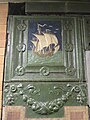
Original cartouche featuring Columbus's ship the Santa Maria
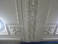
Detailed view of the ceiling

The uptown platform in 1978


IND Eighth Avenue Line platforms[]
59 Street–Columbus Circle | |||
|---|---|---|---|
 Uptown platform | |||
| Station statistics | |||
| Division | B (IND)[45] | ||
| Line | IND Eighth Avenue Line | ||
| Services | A B C D | ||
| Structure | Underground | ||
| Platforms | 3 island platforms (2 in passenger service) cross-platform interchange | ||
| Tracks | 4 | ||
| Other information | |||
| Opened | September 10, 1932[34] | ||
| Station code | 161[4] | ||
| Accessible | |||
| Opposite- direction transfer | Yes | ||
| Station succession | |||
| Next north | 125th Street (express): A 72nd Street (local): A | ||
| Next south | Seventh Avenue (6th): B 50th Street (8th local): A 42nd Street–Port Authority Bus Terminal (8th express): A | ||
| |||
| |||
59th Street–Columbus Circle on the IND Eighth Avenue Line is a large express station. There are four tracks and three island platforms with the outer two in revenue service.
South of the station, trains can either continue on Eighth Avenue or diverge east to the Seventh Avenue station via the IND Sixth Avenue Line. North of the station are crossovers in both directions, and the northbound tracks cross over the southbound tracks to form a two-level configuration to 103rd Street. The next express station to the north, 125th Street, is 3.35 miles (5.4 km) away with seven local stations in between. This is the longest distance between two express stops in the system.
At the middle of each open platform, there are two staircases and one elevator that connect with the northbound platform of IRT Broadway–Seventh Avenue Line. There is also one staircase from each platform at the north end leading to the same area. A single staircase at the extreme south end connects to the southbound IRT platform. There are two newsstands, one each at the center of both platforms.
This station formerly had a 1992 artwork called Hello Columbus, made by various New York City artists and public school students. Sol LeWitt created tile work on the stairway from the IND platforms to the uptown IRT platform entitled Whirls and Twirls, installed in 2009.[38] Large white "59"s are placed over the blue stripes–similar to the "42"s at 42nd Street–Port Authority.
Nearby points of interest[]
- Church of St. Paul the Apostle[36]
- Museum of Arts & Design[36]
- New York Institute of Technology[36]
- Professional Children's School[36]
- John Jay College of Criminal Justice[36]
- Fordham University[36]
References[]
- ^ "Borough of Manhattan, New York City". Government of New York City. Retrieved December 28, 2020.
- ^ "Glossary". Second Avenue Subway Supplemental Draft Environmental Impact Statement (SDEIS) (PDF). 1. Metropolitan Transportation Authority. March 4, 2003. pp. 1–2. Archived from the original (PDF) on February 26, 2021. Retrieved January 1, 2021.
- ^ "Transfer Points Under Higher Fare". The New York Times. June 30, 1948. p. 19.
- ^ Jump up to: a b c "Station Developers' Information". Metropolitan Transportation Authority. Retrieved June 13, 2017.
- ^ Jump up to: a b "Facts and Figures: Annual Subway Ridership 2014–2019". Metropolitan Transportation Authority. 2020. Retrieved May 26, 2020.
- ^ Jump up to: a b "Facts and Figures: Annual Subway Ridership 2014–2019". Metropolitan Transportation Authority. 2020. Retrieved May 26, 2020.
- ^ "Transfer Points Under Higher Fare; Board of Transportation Lists Stations and Intersections for Combined Rides". The New York Times. June 30, 1948. ISSN 0362-4331. Retrieved December 24, 2020.
- ^ Dunlap, David W. (September 26, 2002). "Blocks; Trade-Offs and Reminders at 59th St". The New York Times. ISSN 0362-4331. Retrieved February 11, 2021.
- ^ Chan, Sewell (July 17, 2008). "2 New Subway Entrances Open at Columbus Circle". The New York Times. ISSN 0362-4331. Retrieved February 11, 2021.
- ^ Chaban, Matt A. V. (October 7, 2014). "In Depths of Columbus Circle, a Retail Hub Blooms". The New York Times. ISSN 0362-4331. Retrieved February 11, 2021.
- ^ Jump up to: a b c d e f g Walker, James Blaine (1918). Fifty Years of Rapid Transit — 1864 to 1917. New York, N.Y.: Law Printing. Retrieved November 6, 2016.
- ^ Jump up to: a b c d e f g "Interborough Rapid Transit System, Underground Interior" (PDF). New York City Landmarks Preservation Commission. October 23, 1979. Retrieved November 19, 2019.
- ^ Jump up to: a b Report of the Board of Rapid Transit Railroad Commissioners for the City of New York For The Year Ending December 31, 1904 Accompanied By Reports of the Chief Engineer and of the Auditor. Board of Rapid Transit Railroad Commissioners. 1905. pp. 229–236.
- ^ Jump up to: a b "Our Subway Open: 150,000 Try It; Mayor McClellan Runs the First Official Train". The New York Times. October 28, 1904. p. 1. ISSN 0362-4331. Retrieved April 21, 2020.
- ^ Jump up to: a b c d e f g h i j k "New York MPS 59th Street--Columbus Circle Subway Station (IRT)". Records of the National Park Service, 1785 - 2006, Series: National Register of Historic Places and National Historic Landmarks Program Records, 2013 - 2017, Box: National Register of Historic Places and National Historic Landmarks Program Records: New York, ID: 75313889. National Archives.
- ^ "Our First Subway Completed At Last — Opening of the Van Cortlandt Extension Finishes System Begun in 1900 — The Job Cost $60,000,000 — A Twenty-Mile Ride from Brooklyn to 242d Street for a Nickel Is Possible Now". The New York Times. August 2, 1908. p. 10. Retrieved November 6, 2016.
- ^ Brooklyn Daily Eagle Almanac. Brooklyn Daily Eagle. 1916. p. 119.
- ^ "Open New Subway Lines to Traffic; Called a Triumph" (PDF). The New York Times. August 2, 1918. p. 1. ISSN 0362-4331. Retrieved October 4, 2011.
- ^ Hood, Clifton (1978). "The Impact of the IRT in New York City" (PDF). Historic American Engineering Record. pp. 146–207 (PDF pp. 147–208). Retrieved December 20, 2020.
 This article incorporates text from this source, which is in the public domain.CS1 maint: postscript (link)
- ^ Jump up to: a b Report of the Public Service Commission for the First District of the State of New York For The Year Ending December 31, 1910. Public Service Commission. 1911.
- ^ Authority, New York City Transit (1953). Report.
- ^ Minutes and Proceedings. New York City Transit Authority. 1955. pp. 3, 254, 1457.
- ^ Brown, Nicole (May 17, 2019). "How did the MTA subway lines get their letter or number? NYCurious". amNewYork. Retrieved January 27, 2021.
- ^ Friedlander, Alex; Lonto, Arthur; Raudenbush, Henry (April 1960). "A Summary of Services on the IRT Division, NYCTA" (PDF). New York Division Bulletin. Electric Railroaders' Association. 3 (1): 2–3.
- ^ "Wagner Praises Modernized IRT — Mayor and Transit Authority Are Hailed as West Side Changes Take Effect". The New York Times. February 7, 1959. p. 21. Retrieved November 6, 2016.
- ^ "12 IRT Subway Stops Get Landmark Status". The New York Times. October 27, 1979. ISSN 0362-4331. Retrieved December 26, 2020.
- ^ Brozan, Nadine (June 4, 1989). "'Skip-Stop' Subway Plan Annoys No. 1 Riders". The New York Times. ISSN 0362-4331. Retrieved June 15, 2016.
- ^ Moore, Keith (June 10, 1988). "TA's skip-stop plan hit". New York Daily News. Retrieved November 8, 2018.
- ^ "#1 Riders: Your Service is Changing". New York Daily News. August 20, 1989. Retrieved November 8, 2018.
- ^ "Announcing 1 and 9 Skip-Stop Service on the Broadway-Seventh Avenue Line" (PDF). New York City Transit Authority. August 1989. Archived from the original (PDF) on June 26, 2020. Retrieved August 1, 2009.
- ^ Lorch, Donatella (August 22, 1989). "New Service For Subways On West Side". The New York Times. ISSN 0362-4331. Retrieved June 15, 2016.
- ^ Chan, Sewell (May 25, 2005). "On Its Last Wheels, No. 9 Line Is Vanishing on Signs". The New York Times. ISSN 0362-4331. Retrieved August 29, 2016.
- ^ "Noteworthy – 9 discontinued". mta.info. Metropolitan Transportation Authority. May 7, 2005. Archived from the original on May 7, 2005. Retrieved September 18, 2016.
- ^ Jump up to: a b "List of the 28 Stations on the New 8th Av. Line". The New York Times. September 10, 1932. p. 6. ISSN 0362-4331. Retrieved April 21, 2020.
- ^ "PLAN HUGE CENTRE OF SUBWAY TRAFFIC; Transit Lines Will Build Dual Station at Columbus Circle Four Blocks in Length. 16 ENTRANCES PROPOSED Growth of Section From 1905 to 1926 Is Indicated by Rise of 7,167,592 Fares". The New York Times. April 24, 1927. Retrieved October 6, 2018.
- ^ Jump up to: a b c d e f g h i j "MTA Neighborhood Maps: Midtown West" (PDF). mta.info. Metropolitan Transportation Authority. 2015. Retrieved December 11, 2015.
- ^ Kral, Georgia (April 19, 2016). "Inside TurnStyle, the food and retail hub under Columbus Circle". am New York. Retrieved November 28, 2017.
- ^ Jump up to: a b Review of the A and C Lines (PDF) (Report). Metropolitan Transportation Authority. December 11, 2015. Archived from the original (PDF) on February 3, 2020. Retrieved January 19, 2016.
- ^ * NYC Transit Committee Agenda September 1994. New York City Transit. September 16, 1994. pp. D.70.
- NYC Transit Committee Agenda September 1994. New York City Transit. September 16, 1994. pp. D.71.
- NYC Transit Committee Agenda September 1994. New York City Transit. September 16, 1994. pp. D.72.
- NYC Transit Committee Agenda September 1994. New York City Transit. September 16, 1994. pp. D.73.
- NYC Transit Committee Agenda September 1994. New York City Transit. September 16, 1994. pp. D.74.
- NYC Transit Committee Agenda September 1994. New York City Transit. September 16, 1994. pp. D.75.
- ^ "Glossary". Second Avenue Subway Supplemental Draft Environmental Impact Statement (SDEIS) (PDF). 1. Metropolitan Transportation Authority. March 4, 2003. pp. 1–2. Archived from the original (PDF) on February 26, 2021. Retrieved January 1, 2021.
- ^ Dougherty, Peter (2006) [2002]. Tracks of the New York City Subway 2006 (3rd ed.). Dougherty. OCLC 49777633 – via Google Books.
- ^ Jump up to: a b c d e f g Framberger, David J. (1978). "Architectural Designs for New York's First Subway" (PDF). Historic American Engineering Record. pp. 1-46 (PDF pp. 367-412). Retrieved December 20, 2020. This article incorporates text from this source, which is in the public domain.CS1 maint: postscript (link)
- ^ "High-Speed Broadway Local Service Began in 1959". The Bulletin. New York Division, Electric Railroaders' Association. 52 (2). February 2009. Retrieved August 26, 2016 – via Issuu.
- ^ Scott, Charles (1978). "Design and Construction of the IRT: Civil Engineering" (PDF). Historic American Engineering Record. pp. 208–282 (PDF pp. 209–283). Retrieved December 20, 2020. This article incorporates text from this source, which is in the public domain.CS1 maint: postscript (link)
- ^ "Glossary". Second Avenue Subway Supplemental Draft Environmental Impact Statement (SDEIS) (PDF). 1. Metropolitan Transportation Authority. March 4, 2003. pp. 1–2. Archived from the original (PDF) on February 26, 2021. Retrieved January 1, 2021.
Further reading[]
- Stookey, Lee (1994). Subway ceramics : a history and iconography of mosaic and bas relief signs and plaques in the New York City subway system. Brattleboro, Vt: L. Stookey. ISBN 978-0-9635486-1-0. OCLC 31901471.
External links[]
| Wikimedia Commons has media related to 59th Street – Columbus Circle (New York City Subway). |
- nycsubway.org – IRT West Side Line: 59th Street/Columbus Circle
- nycsubway.org – IND 8th Avenue: 59th Street/Columbus Circle
- nycsubway.org – Whirls and Twirls Artwork by Sol Lewitt (2007)
- nycsubway.org – Hello Columbus Artwork by the NYC Artists & Public School Students (1992)
- Forgotten NY – Original 28 - NYC's First 28 Subway Stations
- MTA's Arts For Transit – 59th Street–Columbus Circle
| show Stations of the New York City Subway, by service |
|---|
| show Stations of the New York City Subway, by line (physical trackage) |
|---|
| show Central Park |
|---|
| show U.S. National Register of Historic Places in New York |
|---|

- Accessible New York City Subway stations
- IRT Broadway–Seventh Avenue Line stations
- Broadway (Manhattan)
- IND Eighth Avenue Line stations
- Eighth Avenue (Manhattan)
- Columbus Circle
- Railway and subway stations on the National Register of Historic Places in Manhattan
- New York City Subway stations in Manhattan
- Railway stations in the United States opened in 1904
- Railway stations in the United States opened in 1932
- New York City Subway transfer stations
- 1904 establishments in New York (state)
- 1932 establishments in New York (state)
- New York City Subway stations located underground
- New York City Designated Landmarks in Manhattan
- New York City interior landmarks
- 59th Street (Manhattan)