Broadway–Lafayette Street/Bleecker Street station
Broadway–Lafayette Street/ Bleecker Street | |||
|---|---|---|---|
 One of the two street stairs along the south side of East Houston Street between Broadway and Crosby Street | |||
| Station statistics | |||
| Address | Houston Street & Lafayette Street New York, NY 10012[1] | ||
| Borough | Manhattan | ||
| Locale | NoHo, SoHo, Greenwich Village | ||
| Coordinates | 40°43′33″N 73°59′41″W / 40.72583°N 73.99472°WCoordinates: 40°43′33″N 73°59′41″W / 40.72583°N 73.99472°W | ||
| Division | A (IRT), B (IND)[2] | ||
| Line | IND Sixth Avenue Line IRT Lexington Avenue Line | ||
| Services | 4 6 B D F M | ||
| Transit | |||
| Other information | |||
| Opened | May 19, 1957 (IND–southbound IRT) September 25, 2012 (IND–northbound IRT) | ||
| Station code | 619[3] | ||
| Accessible | |||
| Traffic | |||
| 2019 | 12,455,155[5] | ||
| Rank | 22 out of 424[5] | ||
| |||
| |||
| |||


Broadway–Lafayette Street/Bleecker Street is a New York City Subway station complex in the NoHo neighborhood of Manhattan on the IRT Lexington Avenue Line and the IND Sixth Avenue Line. It is served by the 6, D, and F trains at all times; the B and M trains on weekdays; the <6> and <F> trains during rush hours in the peak direction; and the 4 train during late nights.
The complex comprises two stations, Bleecker Street and Broadway–Lafayette Street. The Bleecker Street station was built for the Interborough Rapid Transit Company (IRT), and was a local station on the city's first subway line, which was approved in 1900. The station opened on October 27, 1904, as one of the original 28 stations of the New York City Subway. The Broadway–Lafayette Street station was built as an express station for the Independent Subway System (IND) and opened on January 1, 1936.
The Bleecker Street station has two side platforms and four tracks; express trains use the inner two tracks to bypass the station. The Broadway–Lafayette Street station has two island platforms and four tracks. The transfer between the downtown IRT platform and the IND platform has been within fare control since May 19, 1957, and the corresponding free transfer from the uptown IRT platform to the rest of the station opened on September 25, 2012. The station complex contains elevators, which make it compliant with the Americans with Disabilities Act of 1990. The original portion of the Bleecker Street station's interior is a New York City designated landmark and listed on the National Register of Historic Places.
History[]
IRT Lexington Avenue Line[]
Planning for a subway line in New York City dates to 1864.[6]:21 However, development of what would become the city's first subway line did not start until 1894, when the New York State Legislature authorized the Rapid Transit Act.[6]:139–140 The subway plans were drawn up by a team of engineers led by William Barclay Parsons, chief engineer of the Rapid Transit Commission. It called for a subway line from New York City Hall in lower Manhattan to the Upper West Side, where two branches would lead north into the Bronx.[7]:3 A plan was formally adopted in 1897,[6]:148 and all legal conflicts concerning the route alignment were resolved near the end of 1899.[6]:161 The Rapid Transit Construction Company, organized by John B. McDonald and funded by August Belmont Jr., signed the initial Contract 1 with the Rapid Transit Commission in February 1900,[8] in which it would construct the subway and maintain a 50-year operating lease from the opening of the line.[6]:165 In 1901, the firm of Heins & LaFarge was hired to design the underground stations.[7]:4 Belmont incorporated the Interborough Rapid Transit Company (IRT) in April 1902 to operate the subway.[6]:182
The Bleecker Street station was constructed as part of the route segment from Chambers Street to Great Jones Street. Construction on this section of the line began on July 10, 1900, and was awarded to Degnon-McLean Contracting Company.[8] In the vicinity of the Bleecker Street station, the subway was to run under Lafayette Street,[9][10]:17 a new thoroughfare constructed between 1897[11] and 1905.[12] This involved widening, connecting, and renaming two formerly unconnected streets: Elm Street, which ran south of Houston Street, and Lafayette Place, which ran north of Great Jones Street to an intersection with Astor Place.[9][10]:17–18[13] The southward extension of Lafayette Street and the construction of the subway required the demolition or underpinning of several buildings in the street's path. This resulted in the creation of narrow land lots on either side of Lafayette Street between Houston and Great Jones Streets, an area that included the Bleecker Street station's site.[9][10]:18
The Bleecker Street station opened on October 27, 1904, as one of the original 28 stations of the New York City Subway from City Hall to 145th Street on the Broadway–Seventh Avenue Line.[14][6]:186 The opening of the first subway line, and particularly the Bleecker Street station, helped contribute to more development in the East Village, which at the time was already densely populated.[15]:8 After the first subway line was completed in 1908,[16] the station was served by local trains along both the West Side (now the Broadway–Seventh Avenue Line to Van Cortlandt Park–242nd Street) and East Side (now the Lenox Avenue Line). West Side local trains had their southern terminus at City Hall during rush hours and South Ferry at other times, and had their northern terminus at 242nd Street. East Side local trains ran from City Hall to Lenox Avenue (145th Street).[17] In 1918, the Lexington Avenue Line opened north of Grand Central–42nd Street, thereby dividing the original line into an "H"-shaped system. All local trains were sent via the Lexington Avenue Line, running along the Pelham Line in the Bronx.[18]
To address overcrowding, in 1909, the New York Public Service Commission proposed lengthening platforms at stations along the original IRT subway.[19]:168 As part of a modification to the IRT's construction contracts, made on January 18, 1910, the company was to lengthen station platforms to accommodate ten-car express and six-car local trains. In addition to $1.5 million (equivalent to $41.7 million in 2020) spent on platform lengthening, $500,000 (equivalent to $13,888,000 in 2020) was spent on building additional entrances and exits. It was anticipated that these improvements would increase capacity by 25 percent.[20]:15 The Bleecker Street station's northbound platform was extended north by 30 feet (9.1 m), while the southbound platform was extended south by 25 feet (7.6 m).[20]:107
IND Sixth Avenue Line[]
New York City mayor John Francis Hylan's original plans for the Independent Subway System (IND), proposed in 1922, included building over 100 miles (160 km) of new lines and taking over nearly 100 miles (160 km) of existing lines, which would compete with the IRT and the Brooklyn–Manhattan Transit Corporation (BMT), the two major subway operators of the time.[21][22] The IND Sixth Avenue Line was designed to replace the elevated IRT Sixth Avenue Line.[23] The first portion of the line to be constructed was then known as the Houston–Essex Street Line, which ran under Houston, Essex, and Rutgers Streets. The contract for the line was awarded to Corson Construction in January 1929,[24] and construction of this section officially started in May 1929.[25]
The Broadway–Lafayette Street station opened on January 1, 1936, as one of four stations on the first part of the Sixth Avenue Line. Two local tracks split from a junction with the Eighth Avenue Line south of West Fourth Street–Washington Square, running east under Houston Street and south under Essex Street to a temporary terminal at East Broadway.[26] The station was initially served by E trains to Church Avenue.[27][28] When further sections of the Sixth Avenue Line opened on December 15, 1940, the F train replaced the E train at the Broadway–Lafayette Street station.[29] On November 26, 1967, the first part of the Chrystie Street Connection opened, connecting the express tracks at the Broadway–Lafayette Street station to the Manhattan Bridge, and the express tracks started to be used by the B and D trains.[30] On July 1, 1968, the portion of the Chrystie Street Connection connecting the station's local tracks with the Williamsburg Bridge opened.[31] The Williamsburg Bridge connection has been used by the M train since 2010.[32]
Modifications and transfers[]
In late 1959, contracts were awarded to extend the platforms at Bowling Green, Wall Street, Fulton Street, Canal Street, Spring Street, Bleecker Street, Astor Place, Grand Central–42nd Street, 86th Street, and 125th Street to 525 feet (160 m).[33] A free transfer passageway from the downtown IRT platform to the IND platform opened on May 19, 1957, after the IRT station's platforms were lengthened by two cars to accommodate 10-car trains.[34][35] This "one-way" transfer was purely coincidental, and was not intended in the original construction.[35] The construction of a connection from the northbound platform would have required more extensive construction, including knocking down support walls and digging a tunnel. The northbound platform was extended two car lengths to the north because it was easier to do and cost less.[36] As a result, a free transfer was not available to the northbound platform and access to it required a one-block walk north to Bleecker Street and payment of an additional fare except to Unlimited-Ride MetroCard holders.[37] In April 1960, work began on a $3,509,000 project (equivalent to $30.7 million in 2020) to lengthen platforms at seven IRT Lexington Avenue Line stations to accommodate ten-car trains. The northbound platforms at Canal Street, Spring Street, Bleecker Street, and Astor Place were lengthened from 225 to 525 feet (69 to 160 m); the platform extensions at these stations opened on February 19, 1962.[38]
A transfer between the IND platforms and the uptown IRT platform had been planned since 1989, with its inclusion in the Metropolitan Transportation Authority (MTA)'s Third Capital Program.[37] Construction on the transfer would have started in 1992 pending the approval of the program by the State Legislature. The MTA estimated that 15,000 daily passengers would use the free transfer.[36] However, it was not built until the MTA's 2005–2009 capital program allocated $50 million to renovate the complex, which included installation of ADA-accessible elevators and a free transfer to the uptown IRT platform. Prior to the reconstruction, the Broadway–Lafayette Street station connected only to the southbound platform of Bleecker Street at the extreme south end.[39] On March 26, 2012, the uptown platform was shifted 300 feet (91 m) south to the newly constructed extension and the 1950s northern extension closed at the same time. On the same day, the MTA had stated that the transfer project to the uptown Bleecker Street platform would be completed at the end of June.
The uptown transfer did not fully open until September 25, 2012. The overall cost of the rehabilitation project had climbed to $135 million.[40] On the same day, an escalator connected the uptown platform of the Broadway-Lafayette Street station with a new transfer mezzanine that connected riders to the uptown platform of the Bleecker Street station. In addition, elevators were installed to connect the various platforms of the IND station, and those of Bleecker Street.[41][42][43] The transfer contained new elevators and escalators to the IND station below. The street-level elevator accesses the southbound IRT platform directly, while four other elevators in the station connect each IND platform with each IRT platform.[44]
Station layout[]
| G | Street level | Exits/entrances |
| B1 | East mezzanine | Fare control, exits to east side of Lafayette Street |
| Side platform | ||
| Northbound local | ← ← | |
| Northbound express | ← | |
| Southbound express | | |
| Southbound local | | |
| Side platform | ||
| West mezzanine | Fare control, station agent, exits to Houston Street and west side of Lafayette Street | |
| B2 | Mezzanine | Transfer between platforms |
| B3 | Northbound local | ← ← |
| Island platform | ||
| Northbound express | ← ← | |
| Southbound express | | |
| Island platform | ||
| Southbound local | | |
A passageway connects the downtown IRT platform under Lafayette Street and the mezzanine at Broadway. There is a lower level mezzanine for the IND underneath the IRT platforms.
Exits[]

The station has a total of 12 staircase entrances and 1 elevator entrance. They are clustered in three locations: the intersection of Broadway and Houston Street, the intersection of Lafayette and Houston Streets, and the intersection of Lafayette and Bleecker Streets, The exits at Houston Street primarily serve the IND platforms while the exits at Lafayette Street primarily serve the IRT platforms. The northbound IRT platform's exits are on the eastern side of Lafayette Street while the southbound platform's exits are on the western side.[45]
There are two stairs at Broadway and Houston Street, one at either eastern corner.[45] The southeastern one is built inside an alcove of an Adidas Sport Performance Center. It leads to the full-time entrance to the IND station, above the center of that station, which contains a turnstile bank and token booth.[46] There are closed staircases from the extreme western ends of both platforms that lead to a western mezzanine with exits to the west side of Broadway and Houston Street. It is currently used by employees.
The upper IND mezzanine has two fare control areas that are shared with the southbound IRT platform. A set of turnstiles on the south side leads to two staircases at the southeast corner of Lafayette and Houston Streets. Another set of turnstiles on the north side leads to a stair and an elevator on the northwest corner of Lafayette and Houston Streets. The extreme east end of the IND station contains stairs and escalators to the eastern mezzanine, which is shared with the northbound IRT platform. This mezzanine contains two stairs, one to each eastern corner of Houston and Lafayette Streets.[45]
There are five stairs near Lafayette and Bleecker Streets. One stair each goes to the northwestern and southwestern corners of Lafayette and Bleecker Streets, and serve the southbound IRT platform. One stair each goes to the northeastern, southwestern, and southeastern corners of Mulberry and Bleecker Streets, and serve the northbound IRT platform.[15]:4[45]
IRT Lexington Avenue Line platforms[]
Bleecker Street | |||
|---|---|---|---|
 Platform for the uptown local 6 train | |||
| Station statistics | |||
| Division | A (IRT)[47] | ||
| Line | IRT Lexington Avenue Line | ||
| Services | 4 6 | ||
| Structure | Underground | ||
| Platforms | 2 side platforms | ||
| Tracks | 4 | ||
| Other information | |||
| Opened | October 27, 1904[14] | ||
| Station code | 408[3] | ||
| Accessible | |||
| Opposite- direction transfer | Yes | ||
| Station succession | |||
| Next north | Astor Place: 4 | ||
| Next south | Spring Street: 4 | ||
| |||
| |||
Bleecker Street Subway Station (IRT) | |||
U.S. National Register of Historic Places | |||
New York City Landmark No. 1096 | |||
| MPS | New York City Subway System MPS | ||
| NRHP reference No. | 04001012[15] | ||
| NYCL No. | 1096 | ||
| Significant dates | |||
| Added to NRHP | September 17, 2004 | ||
| Designated NYCL | October 23, 1979[7] | ||
Bleecker Street is a local station on the IRT Lexington Avenue Line with four tracks and two side platforms. The 6 stops here at all times,[48] rush-hour and midday <6> trains stop here in the peak direction;[48] and the 4 stops here during late nights.[49] The two express tracks are used by the 4 train during daytime hours and the 5 train at all times.[50] The platforms were originally 200 feet (61 m) long, as at other local stations on the original IRT,[7]:4[15]:3 but as a result of the 1959 platform extensions, became 525 feet (160 m) long.[33] The platform extensions were originally at the front ends of the original platforms: the southbound platform was extended southward and the northbound platform was extended northward.[51]:33 After the 2012 renovation, the northbound platform was extended to the south, and the northern extension of that platform was closed.[40]
In 1979, the New York City Landmarks Preservation Commission designated the space within the boundaries of the original station, excluding expansions made after 1904, as a city landmark. The station was designated along with eleven others on the original IRT.[7][52] The original interiors were listed on the National Register of Historic Places in 2004.[15]
Design[]
As with other stations built as part of the original IRT, the station was constructed using a cut-and-cover method.[53]:237 The tunnel is covered by a "U"-shaped trough that contains utility pipes and wires. The bottom of this trough contains a foundation of concrete no less than 4 inches (100 mm) thick.[15]:3–4[51]:9 Each platform consists of 3-inch-thick (7.6 cm) concrete slabs, beneath which are drainage basins. The original platforms contain circular, cast-iron Tuscan-style columns spaced every 15 feet (4.6 m), while the platform extensions contain I-beam columns. Additional columns between the tracks, spaced every 5 feet (1.5 m), support the jack-arched concrete station roofs.[15]:3–4[7]:4[51]:9 The ceiling height varies based on whether there are utilities in the ceiling; the areas without utilities is about 15 feet (4.6 m) above platform level. There is a 1-inch (25 mm) gap between the trough wall and the platform walls, which are made of 4-inch (100 mm)-thick brick covered over by a tiled finish.[15]:3–4[51]:9
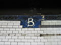
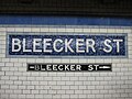
The fare control areas are at platform level.[15]:4 The crossunder between the platforms is via the IND station.[40] The walls along the platforms near the fare control areas consist of a brick wainscoting on the lowest part of the wall, with bronze air vents along the wainscoting, and white glass tiles above. Bands of blue mosaic tiles run above the wainscoting. A cornice with foliate motifs runs above each wall, with faience plaques containing the "B" placed at 15-foot (4.6 m) interval. On the walls are placed large oval tablets with the white letters "Bleecker Street" on a blue frame.[15]:4–5[7]:7 The mosaic tiles at all original IRT stations were manufactured by the American Encaustic Tile Company, which subcontracted the installations at each station.[51]:31 The decorative work was performed by faience contractor Grueby Faience Company.[51]:33 The ceilings of the original platforms and fare control areas contain plaster molding.[15]:4–5[51]:10 The northbound platform contains doorways that formerly led to men's and women's restrooms, with corresponding marble lintels.[15]:5
The northern platform extension of the northbound platform, now walled off, had green tiles and a darker green trim line with "BLEECKER ST" written on it in black sans serif font at regular intervals. These tiles were installed during the late 1950s renovation. The platform extension of the southbound platform had similar tiles, which were removed in the 2012 extension.
Gallery[]

Faience name tablet, Heins & LaFarge/Grueby Faience Company, from 1904
Original cartouche
Pre-renovation Mosaic station tablets by Vickers

Southbound stairway at street
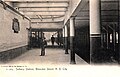
The station used to have skylights to let in natural light (1905)


IND Sixth Avenue Line platforms[]
Broadway–Lafayette Street | |||
|---|---|---|---|
 | |||
| Station statistics | |||
| Division | B (IND)[54] | ||
| Line | IND Sixth Avenue Line | ||
| Services | B D F M | ||
| Structure | Underground | ||
| Platforms | 2 island platforms cross-platform interchange | ||
| Tracks | 4 | ||
| Other information | |||
| Opened | January 1, 1936 | ||
| Station code | 230[3] | ||
| Accessible | |||
| Opposite- direction transfer | Yes | ||
| Station succession | |||
| Next west | West Fourth Street–Washington Square: B | ||
| Next east | Second Avenue (local): F Grand Street (express): B Essex Street (local via Chyrstie St.): M | ||
| |||
| |||
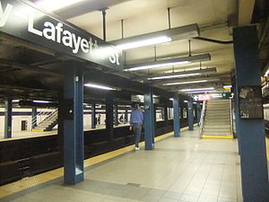
Broadway–Lafayette Street on the IND Sixth Avenue Line is an express station, located on East Houston Street between Broadway and Lafayette Street in Manhattan. It has four tracks and two island platforms.[50] The inner express tracks are served by the B during weekdays[55] and the D at all times.[56] The outer local tracks are served by the F at all times, the <F> during rush hours in the peak direction,[57] and the M during weekdays.[58]
The centers of both platforms have three staircases that go up to a mezzanine, where wide staircases on either side go up to the station's three fare control areas.
Design[]
Both outer track walls have a blue trim line on a black border and small "BROADWAY" signs beneath in white lettering on a black border. Large blue columns run along either side of both platforms at regular intervals with alternating ones having the standard black station name plate and white lettering.
Track layout[]
West (railroad north) of this station, there are crossovers between the two northbound tracks and a single one between the express tracks. The line turns north along Sixth Avenue and goes through a complex set of switches and crossovers with the IND Eighth Avenue Line before arriving at West Fourth Street–Washington Square.[50]
East (railroad south) of this station, there used to be a crossover between the two southbound tracks before they were reconfigured in 1967 by the Chrystie Street Connection. B and D trains turn south down Chrystie Street with a stop at Grand Street before crossing the Manhattan Bridge into Brooklyn. F trains continue directly east with a stop at Second Avenue, turn south on Essex Street with two more stops at Delancey Street and East Broadway, before passing under the East River through the Rutgers Street Tunnel into Brooklyn. M trains use a connection that leads to Essex Street on the BMT Nassau Street Line before crossing the Williamsburg Bridge into Brooklyn.[50]
Art []
The 1998 artwork in the IND station is called Signal by Mel Chin. It features stainless steel and glass sculptures with lights on the mezzanine walls and ceramic tiles on the platform walls.
A new MTA's Arts for Transit project was created in 2012, called Hive, by Leo Villareal. It is located at the newest section of the uptown platform in the mezzanine providing the transfer to the IND station.[59]
References[]
- ^ "Borough of Manhattan, New York City". Government of New York City. Retrieved December 28, 2020.
- ^ "Glossary". Second Avenue Subway Supplemental Draft Environmental Impact Statement (SDEIS) (PDF). 1. Metropolitan Transportation Authority. March 4, 2003. pp. 1–2. Archived from the original (PDF) on February 26, 2021. Retrieved January 1, 2021.
- ^ Jump up to: a b c "Station Developers' Information". Metropolitan Transportation Authority. Retrieved June 13, 2017.
- ^ "Facts and Figures: Annual Subway Ridership 2014–2019". Metropolitan Transportation Authority. 2020. Retrieved May 26, 2020.
- ^ Jump up to: a b "Facts and Figures: Annual Subway Ridership 2014–2019". Metropolitan Transportation Authority. 2020. Retrieved May 26, 2020.
- ^ Jump up to: a b c d e f g Walker, James Blaine (1918). Fifty Years of Rapid Transit — 1864 to 1917. New York, N.Y.: Law Printing. Retrieved November 6, 2016.
- ^ Jump up to: a b c d e f g "Interborough Rapid Transit System, Underground Interior" (PDF). New York City Landmarks Preservation Commission. October 23, 1979. Retrieved November 19, 2019.
- ^ Jump up to: a b Report of the Board of Rapid Transit Railroad Commissioners for the City of New York For The Year Ending December 31, 1904 Accompanied By Reports of the Chief Engineer and of the Auditor. Board of Rapid Transit Railroad Commissioners. 1905. pp. 229–236.
- ^ Jump up to: a b c Gray, Christopher (June 17, 2010). "Along Lafayette Street, Some Very Odd Lots". The New York Times. ISSN 0362-4331. Retrieved February 2, 2021.
- ^ Jump up to: a b c Presa, Donald G. (June 29, 1999). "NoHo Historic District" (PDF). New York City Landmarks Preservation Commission. Retrieved February 2, 2021.
- ^ Hanly, Thomas B. (November 7, 1897). "Elm Street Past and Present" (PDF). The New York Times. p. 32. ISSN 0362-4331. Retrieved February 2, 2021.
- ^ "Elm Street Off the Map" (PDF). The New York Times. April 26, 1905. p. 1. ISSN 0362-4331. Retrieved February 2, 2021.
- ^ Moscow, Henry (1978). The Street Book: An Encyclopedia of Manhattan's Street Names and Their Origins. New York: Hagstrom Company. p. 67. ISBN 978-0-8232-1275-0.
- ^ Jump up to: a b "Our Subway Open: 150,000 Try It; Mayor McClellan Runs the First Official Train". The New York Times. October 28, 1904. p. 1. ISSN 0362-4331. Retrieved April 21, 2020.
- ^ Jump up to: a b c d e f g h i j k l "New York MPS Bleecker Street Subway Station (IRT)". Records of the National Park Service, 1785 - 2006, Series: National Register of Historic Places and National Historic Landmarks Program Records, 2013 - 2017, Box: National Register of Historic Places and National Historic Landmarks Program Records: New York, ID: 75313929. National Archives.
- ^ "Our First Subway Completed At Last — Opening of the Van Cortlandt Extension Finishes System Begun in 1900 — The Job Cost $60,000,000 — A Twenty-Mile Ride from Brooklyn to 242d Street for a Nickel Is Possible Now". The New York Times. August 2, 1908. p. 10. Retrieved November 6, 2016.
- ^ Brooklyn Daily Eagle Almanac. Brooklyn Daily Eagle. 1916. p. 119.
- ^ "Open New Subway Lines to Traffic; Called a Triumph — Great H System Put in Operation Marks an Era in Railroad Construction — No Hitch in the Plans — But Public Gropes Blindly to Find the Way in Maze of New Stations — Thousands Go Astray — Leaders in City's Life Hail Accomplishment of Great Task at Meeting at the Astor" (PDF). The New York Times. August 2, 1918. p. 1. Retrieved November 6, 2016.
- ^ Hood, Clifton (1978). "The Impact of the IRT in New York City" (PDF). Historic American Engineering Record. pp. 146–207 (PDF pp. 147–208). Retrieved December 20, 2020.
 This article incorporates text from this source, which is in the public domain.CS1 maint: postscript (link)
- ^ Jump up to: a b Report of the Public Service Commission for the First District of the State of New York For The Year Ending December 31, 1910. Public Service Commission. 1911.
- ^ "Two Subway Routes Adopted by City". The New York Times. August 4, 1923. p. 9. ISSN 0362-4331. Retrieved August 1, 2019.
- ^ "Plans Now Ready to Start Subways". The New York Times. March 12, 1924. p. 1. ISSN 0362-4331. Retrieved August 1, 2019.
- ^ "Delaney For Razing Elevated Line Now; Work in 6th Av. Could Begin in Six Months if Condemnation Started at Once, He Says. Sees Cut In Subway Cost Eliminating Need for Underpinning Would Save $4,000,000 and Speed Construction, He Holds". The New York Times. January 11, 1930. ISSN 0362-4331. Retrieved April 27, 2018.
- ^ "East Side Subway Will Evict 10,000; Work on New Line, Likely to Begin in May, Will Force Many Tenants to Move. 200 Buildings Will Fall Transportation Board Notifies Property Owners—Condemnation to Coat Over $11,000,000. Expect Work to Start in May. Residents Recall Other Days". The New York Times. February 24, 1929. ISSN 0362-4331. Retrieved April 28, 2018.
- ^ "East Side Subway Started By Mayor; He Breaks Ground for Crosstown System at Second Av. and East Houston St. Miller Hails Project Sees Area Rejuvenated by Line and City's Plan to Raze Old Tenements". The New York Times. May 2, 1929. ISSN 0362-4331. Retrieved April 28, 2018.
- ^ "LaGuardia Opens New Subway Link". The New York Times. January 2, 1936. p. 1. ISSN 0362-4331. Retrieved October 7, 2011.
- ^ "Two Subway Links Start Wednesday". The New York Times. April 6, 1936. p. 23. ISSN 0362-4331. Retrieved October 7, 2011.
- ^ "New Subway Link Opened by Mayor". The New York Times. April 9, 1936. p. 23. ISSN 0362-4331. Retrieved October 7, 2011.
- ^ "The New Subway Routes". The New York Times. December 15, 1940. ISSN 0362-4331. Retrieved April 15, 2018.
- ^ Perlmutter, Emanuel (November 27, 1967). "BMT-IND Changes Bewilder Many – Transit Authority Swamped With Calls From Riders as New System Starts". The New York Times. ISSN 0362-4331. Retrieved August 23, 2015.
- ^ Hofmann, Paul (July 1, 1968). "Skip-Stop Subway Begins Run Today – KK Line Links 3 Boroughs – Other Routes Changed". The New York Times. ISSN 0362-4331. Retrieved November 27, 2016.
- ^ "Modifications to 2010 NYC Transit Service Reductions" (PDF). mta.info. New York City Transit. March 19, 2010. pp. 4–5. Retrieved August 30, 2016.
- ^ Jump up to: a b Annual Report For The Year Ending June 30, 1959 (PDF). New York City Transit Authority. 1959. p. 9.
- ^ "Passage Links Subways" (PDF). Retrieved October 10, 2016.
- ^ Jump up to: a b Chan, Sewell (May 7, 2005). "With Connection on No. 6 Line, a Manhattan Transfer Is Coming". The New York Times. Retrieved April 27, 2011.
- ^ Jump up to: a b "Only In New York: The Newsletter of the New York City Transit Authority". New York City Transit Authority. 1990. Retrieved April 7, 2019 – via Flickr.
- ^ Jump up to: a b The New York Transit Authority in the 1980s
- ^ "4 IRT Stops To Open Longer Platforms". The New York Times. February 18, 1962. ISSN 0362-4331. Retrieved January 4, 2021.
- ^ With connection to No 6 line, a Manhattan transfer is coming The New York Times Retrieved August 2, 2006
- ^ Jump up to: a b c "Bleecker Street Platform Shifts". MTA.info. March 26, 2012. Retrieved March 27, 2012.
- ^ Redwine, Tina (September 25, 2012). "Transfers At Bleecker Street Are No Longer A Bleak Situation". NY1. Archived from the original on January 30, 2013. Retrieved September 26, 2012.
- ^ Matt Flegenheimer (September 24, 2012). "A Vexing Flaw in the Subway Is Finally Fixed". The New York Times. pp. A18–A19. Retrieved September 28, 2012.
- ^ "Archived copy". Archived from the original on August 13, 2016. Retrieved October 28, 2015.CS1 maint: archived copy as title (link)
- ^ "Bleecker Street Platform Shifts". MTA.info. March 26, 2012. Retrieved March 27, 2012.
- ^ Jump up to: a b c d "MTA Neighborhood Maps: Bleecker St (6)". Metropolitan Transportation Authority. 2018. Retrieved December 25, 2020.
- ^ Downtown Bleecker Street/Broadway–Lafayette Street On NY Turf Retrieved August 28, 2008 Archived July 17, 2011, at the Wayback Machine
- ^ "Glossary". Second Avenue Subway Supplemental Draft Environmental Impact Statement (SDEIS) (PDF). 1. Metropolitan Transportation Authority. March 4, 2003. pp. 1–2. Archived from the original (PDF) on February 26, 2021. Retrieved January 1, 2021.
- ^ Jump up to: a b "6 Subway Timetable, Effective September 13, 2020". Metropolitan Transportation Authority. Retrieved December 9, 2020.
- ^ "4 Subway Timetable, Effective September 13, 2020". Metropolitan Transportation Authority. Retrieved December 9, 2020.
- ^ Jump up to: a b c d Dougherty, Peter (2006) [2002]. Tracks of the New York City Subway 2006 (3rd ed.). Dougherty. OCLC 49777633 – via Google Books.
- ^ Jump up to: a b c d e f g Framberger, David J. (1978). "Architectural Designs for New York's First Subway" (PDF). Historic American Engineering Record. pp. 1–46 (PDF pp. 367–412). Retrieved December 20, 2020. This article incorporates text from this source, which is in the public domain.CS1 maint: postscript (link)
- ^ "12 IRT Subway Stops Get Landmark Status". The New York Times. October 27, 1979. ISSN 0362-4331. Retrieved December 26, 2020.
- ^ Scott, Charles (1978). "Design and Construction of the IRT: Civil Engineering" (PDF). Historic American Engineering Record. pp. 208–282 (PDF pp. 209–283). Retrieved December 20, 2020. This article incorporates text from this source, which is in the public domain.CS1 maint: postscript (link)
- ^ "Glossary". Second Avenue Subway Supplemental Draft Environmental Impact Statement (SDEIS) (PDF). 1. Metropolitan Transportation Authority. March 4, 2003. pp. 1–2. Archived from the original (PDF) on February 26, 2021. Retrieved January 1, 2021.
- ^ "B Subway Timetable, Effective November 8, 2020" (PDF). Metropolitan Transportation Authority. Retrieved December 9, 2020.
- ^ "D Subway Timetable, Effective November 8, 2020" (PDF). Metropolitan Transportation Authority. Retrieved December 9, 2020.
- ^ "F Subway Timetable, Effective November 8, 2020" (PDF). Metropolitan Transportation Authority. Retrieved December 9, 2020.
- ^ "M Subway Timetable, Effective November 8, 2020" (PDF). Metropolitan Transportation Authority. Retrieved December 9, 2020.
- ^ Redwine, Tina (July 21, 2012). "MTA Unveils Digital Art At Bleecker Street Station". NY1. Archived from the original on July 24, 2012. Retrieved July 22, 2012.
External links[]
| External video | |
|---|---|
![]() Media related to Bleecker Street / Broadway – Lafayette Street (New York City Subway) at Wikimedia Commons
Media related to Bleecker Street / Broadway – Lafayette Street (New York City Subway) at Wikimedia Commons
- Forgotten NY – Original 28 - NYC's First 28 Subway Stations
nycsubway.org
- nycsubway.org – IRT East Side Line: Bleecker Street
- nycsubway.org – IND 6th Avenue: Broadway/Lafayette
- nycsubway.org – Signal Artwork by Mel Chin (1998)
Station Reporter
MTA's Arts For Transit
Google Maps Street View
| show Stations of the New York City Subway, by service |
|---|
| show Stations of the New York City Subway, by line (physical trackage) |
|---|
| show U.S. National Register of Historic Places in New York |
|---|

- Accessible New York City Subway stations
- IND Sixth Avenue Line stations
- New York City Subway stations in Manhattan
- New York City Subway stations located underground
- Railway stations in the United States opened in 1936
- New York City Subway transfer stations
- IRT Lexington Avenue Line stations
- Railway and subway stations on the National Register of Historic Places in Manhattan
- Railway stations in the United States opened in 1904
- 1904 establishments in New York (state)
- 1936 establishments in New York (state)
- West Village
- SoHo, Manhattan
- New York City Designated Landmarks in Manhattan
- New York City interior landmarks