Hewes Street station
Hewes Street | ||||||||||||||||||||||||||||||||||||||||||||||||||||||||||||||||||||
|---|---|---|---|---|---|---|---|---|---|---|---|---|---|---|---|---|---|---|---|---|---|---|---|---|---|---|---|---|---|---|---|---|---|---|---|---|---|---|---|---|---|---|---|---|---|---|---|---|---|---|---|---|---|---|---|---|---|---|---|---|---|---|---|---|---|---|---|---|
 Northbound platform | ||||||||||||||||||||||||||||||||||||||||||||||||||||||||||||||||||||
| Station statistics | ||||||||||||||||||||||||||||||||||||||||||||||||||||||||||||||||||||
| Address | Hewes Street & Broadway Brooklyn, NY 11211 | |||||||||||||||||||||||||||||||||||||||||||||||||||||||||||||||||||
| Borough | Brooklyn | |||||||||||||||||||||||||||||||||||||||||||||||||||||||||||||||||||
| Locale | Williamsburg | |||||||||||||||||||||||||||||||||||||||||||||||||||||||||||||||||||
| Coordinates | 40°42′24″N 73°57′11″W / 40.706669°N 73.953009°WCoordinates: 40°42′24″N 73°57′11″W / 40.706669°N 73.953009°W | |||||||||||||||||||||||||||||||||||||||||||||||||||||||||||||||||||
| Division | B (BMT)[1] | |||||||||||||||||||||||||||||||||||||||||||||||||||||||||||||||||||
| Line | BMT Jamaica Line | |||||||||||||||||||||||||||||||||||||||||||||||||||||||||||||||||||
| Services | J M | |||||||||||||||||||||||||||||||||||||||||||||||||||||||||||||||||||
| Transit | ||||||||||||||||||||||||||||||||||||||||||||||||||||||||||||||||||||
| Structure | Elevated | |||||||||||||||||||||||||||||||||||||||||||||||||||||||||||||||||||
| Platforms | 2 side platforms | |||||||||||||||||||||||||||||||||||||||||||||||||||||||||||||||||||
| Tracks | 3 | |||||||||||||||||||||||||||||||||||||||||||||||||||||||||||||||||||
| Other information | ||||||||||||||||||||||||||||||||||||||||||||||||||||||||||||||||||||
| Opened | June 25, 1888[2] | |||||||||||||||||||||||||||||||||||||||||||||||||||||||||||||||||||
| Station code | 100[3] | |||||||||||||||||||||||||||||||||||||||||||||||||||||||||||||||||||
| Opposite- direction transfer | Yes | |||||||||||||||||||||||||||||||||||||||||||||||||||||||||||||||||||
| Traffic | ||||||||||||||||||||||||||||||||||||||||||||||||||||||||||||||||||||
| 2019 | 1,117,566[5] | |||||||||||||||||||||||||||||||||||||||||||||||||||||||||||||||||||
| Rank | 343 out of 424[5] | |||||||||||||||||||||||||||||||||||||||||||||||||||||||||||||||||||
| Station succession | ||||||||||||||||||||||||||||||||||||||||||||||||||||||||||||||||||||
| Next east | Lorimer Street: J | |||||||||||||||||||||||||||||||||||||||||||||||||||||||||||||||||||
| Next west | Marcy Avenue: J | |||||||||||||||||||||||||||||||||||||||||||||||||||||||||||||||||||
| ||||||||||||||||||||||||||||||||||||||||||||||||||||||||||||||||||||
| ||||||||||||||||||||||||||||||||||||||||||||||||||||||||||||||||||||
| ||||||||||||||||||||||||||||||||||||||||||||||||||||||||||||||||||||
| ||||||||||||||||||||||||||||||||||||||||||||||||||||||||||||||||||||


The Hewes Street station is a local station on the BMT Jamaica Line of the New York City Subway. Located at the intersection of Hewes Street and Broadway in Brooklyn, it is served by the J train at all times except weekdays in the peak direction and the M train at all times except late nights. The Z train skips this station when it operates.
History[]
The Union Elevated Railroad, leased to the Brooklyn Elevated Railroad, opened an elevated line above Broadway from Gates Avenue northwest to Driggs Avenue in Williamsburg on June 25, 1888, with a station at Hewes Street.[2]
Station layout[]
| P Platform level |
Side platform | |
| Westbound local[6] | ← ← | |
| Peak-direction express | ← | |
| Eastbound local[6] | | |
| Side platform | ||
| M | Mezzanine | Fare control, station agent, MetroCard machines |
| G | Street level | Entrances/exits |

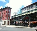
This elevated station, built four stories above street level, has two side platforms and three tracks. The center track is used by the J and Z trains in the peak direction weekday midday and rush hours.[7] Each platform has beige windscreens, green canopies, and red roofs that run from end to end.
The artwork here is called El in 16 Notes by Mara Held. It features sixteen panels of art glass, each containing random geometric shapes and is based on shapes found in dress patterns.
Exits[]
The station has exits on both the west (railroad north) end and the east (railroad south) end of its platforms.
On the west end, each platform has a single staircase leading to an elevated station house beneath the tracks. It has a turnstile bank and token booth. Outside of fare control, two staircases lead to the western corners of Broadway and Hooper Street.[8] Each staircase landing has an exit-only turnstile to allow passengers to exit without having to go through the station house.
On the east end, each platform has a single staircase leading to a turnstile bank. Outside of fare control, a single staircase from each side leads to the eastern corners of Broadway and Hewes Street. The station house has been removed.[9][8] These exits were closed in the 1980s due to high crime and served as emergency exits until 2018.[9][10][11] They were reopened on November 16, 2018 to accommodate L train riders who would be displaced during the 14th Street Tunnel shutdown in 2019–2020.[12] As part of the tunnel shutdown plans, these exits would also contain a temporary MetroCard transfer to the nearby Broadway station on the G train, during weekends and late nights. The transfer was honored through the end of May 2020, even though L train tunnel work was completed on April 26.[13][14]
Gallery[]
Hooper Street stationhouse

Exit-Only Turnstile

Hooper Street entrances

Platform stairs


References[]
- ^ "Glossary". Second Avenue Subway Supplemental Draft Environmental Impact Statement (SDEIS) (PDF). Vol. 1. Metropolitan Transportation Authority. March 4, 2003. pp. 1–2. Archived from the original (PDF) on February 26, 2021. Retrieved January 1, 2021.
- ^ a b "The Broadway Line Opened". Brooklyn Daily Eagle. Brooklyn, NY. June 25, 1888. p. 6.
- ^ "Station Developers' Information". Metropolitan Transportation Authority. Retrieved June 13, 2017.
- ^ "Facts and Figures: Annual Subway Ridership 2014–2019". Metropolitan Transportation Authority. 2020. Retrieved May 26, 2020.
- ^ a b "Facts and Figures: Annual Subway Ridership 2014–2019". Metropolitan Transportation Authority. 2020. Retrieved May 26, 2020.
- ^ a b This is a wrong-way concurrency in railroad direction.
- ^ Dougherty, Peter (2006) [2002]. Tracks of the New York City Subway 2006 (3rd ed.). Dougherty. OCLC 49777633 – via Google Books.
- ^ a b "MTA Neighborhood Maps: Williamsburg & Bedford-Stuyvesant" (PDF). Metropolitan Transportation Authority. 2015. Retrieved July 3, 2015.
- ^ a b Muessig, Ben; Foretek, Jared; Geis, Shannon (August 24, 2009). "MTA still has no 'Hewes' for station entrances". Brooklyn Paper. Retrieved July 15, 2016.
- ^ Harshbarger, Rebecca; De La Hoz, Felipe (October 12, 2015). "Williamsburg, Bushwick subway entrances sealed despite ridership spike". AM New York. Retrieved July 4, 2016.
- ^ "Closed subway entrances". WNYC (AM). October 31, 2015. Retrieved July 4, 2016.
- ^ "New York City Transit and Bus Committee Meeting 11/13/2018" (PDF). mta.info. Metropolitan Transportation Authority. November 2018. p. 94. Retrieved November 17, 2018.
- ^ "Service information for L, M, G, 7, M14 SBS and free transfers". Metropolitan Transit Authority. April 26, 2020. Retrieved May 10, 2020.
- ^ Guse, Clayton (June 1, 2020). "MTA ends free transfer between overlapping Brooklyn subway stations". New York Daily News. Retrieved June 2, 2020.
External links[]
| Wikimedia Commons has media related to Hewes Street (BMT Jamaica Line). |
- nycsubway.org – BMT Jamaica Line: Hewes Street
- Station Reporter — J Train
- Station Reporter — M Train
- The Subway Nut — Hewes Street Pictures
- MTA's Arts For Transit — Hewes Street (BMT Jamaica Line)
- Hooper Street entrance from Google Maps Street View
- Hewes Street entrance from Google Maps Street View
- Platforms from Google Maps Street View
| Jamaica Line |
|
|---|---|
| |
- BMT Jamaica Line stations
- 1888 establishments in New York (state)
- New York City Subway stations in Brooklyn
- New York City Subway stations located aboveground
- Railway stations in the United States opened in 1888
- Williamsburg, Brooklyn