Bowery station
Bowery | |||||||||||||||||||||||||||||||||||||||||||||||||||||||||||||
|---|---|---|---|---|---|---|---|---|---|---|---|---|---|---|---|---|---|---|---|---|---|---|---|---|---|---|---|---|---|---|---|---|---|---|---|---|---|---|---|---|---|---|---|---|---|---|---|---|---|---|---|---|---|---|---|---|---|---|---|---|---|
 | |||||||||||||||||||||||||||||||||||||||||||||||||||||||||||||
| Station statistics | |||||||||||||||||||||||||||||||||||||||||||||||||||||||||||||
| Address | Bowery & Delancey Street New York, NY 10002 | ||||||||||||||||||||||||||||||||||||||||||||||||||||||||||||
| Borough | Manhattan | ||||||||||||||||||||||||||||||||||||||||||||||||||||||||||||
| Locale | Lower East Side, Little Italy | ||||||||||||||||||||||||||||||||||||||||||||||||||||||||||||
| Coordinates | 40°43′13″N 73°59′39″W / 40.720299°N 73.994079°WCoordinates: 40°43′13″N 73°59′39″W / 40.720299°N 73.994079°W | ||||||||||||||||||||||||||||||||||||||||||||||||||||||||||||
| Division | B (BMT)[1] | ||||||||||||||||||||||||||||||||||||||||||||||||||||||||||||
| Line | BMT Nassau Street Line | ||||||||||||||||||||||||||||||||||||||||||||||||||||||||||||
| Services | J Z | ||||||||||||||||||||||||||||||||||||||||||||||||||||||||||||
| Transit | |||||||||||||||||||||||||||||||||||||||||||||||||||||||||||||
| Structure | Underground | ||||||||||||||||||||||||||||||||||||||||||||||||||||||||||||
| Platforms | 2 island platforms (1 in regular service) | ||||||||||||||||||||||||||||||||||||||||||||||||||||||||||||
| Tracks | 3 (2 in regular service; 1 not in regular service; 1 removed) | ||||||||||||||||||||||||||||||||||||||||||||||||||||||||||||
| Other information | |||||||||||||||||||||||||||||||||||||||||||||||||||||||||||||
| Opened | August 4, 1913[2] | ||||||||||||||||||||||||||||||||||||||||||||||||||||||||||||
| Station code | 103[3] | ||||||||||||||||||||||||||||||||||||||||||||||||||||||||||||
| Opposite- direction transfer | Yes | ||||||||||||||||||||||||||||||||||||||||||||||||||||||||||||
| Traffic | |||||||||||||||||||||||||||||||||||||||||||||||||||||||||||||
| 2019 | 1,325,244[5] | ||||||||||||||||||||||||||||||||||||||||||||||||||||||||||||
| Rank | 322 out of 424[5] | ||||||||||||||||||||||||||||||||||||||||||||||||||||||||||||
| Station succession | |||||||||||||||||||||||||||||||||||||||||||||||||||||||||||||
| Next east | Essex Street: J | ||||||||||||||||||||||||||||||||||||||||||||||||||||||||||||
| Next west | Canal Street: J | ||||||||||||||||||||||||||||||||||||||||||||||||||||||||||||
| |||||||||||||||||||||||||||||||||||||||||||||||||||||||||||||
| |||||||||||||||||||||||||||||||||||||||||||||||||||||||||||||
| |||||||||||||||||||||||||||||||||||||||||||||||||||||||||||||
| |||||||||||||||||||||||||||||||||||||||||||||||||||||||||||||


The Bowery station is a station on the BMT Nassau Street Line of the New York City Subway. Located at the intersection of Bowery and Delancey Street in the Lower East Side and Little Italy neighborhoods, it is served by the J train at all times and the Z train during rush hours in the peak direction.
History[]
Construction contracts for the Nassau Street main line in Manhattan were awarded in early 1907, despite no determination of the operator once completed. The line was assigned to a proposed Tri-borough system in early 1908 and to the Brooklyn Rapid Transit Company (BRT) in the Dual Contracts, adopted on March 4, 1913.[6][7] Construction of this underground station began in August 1907 and was almost completed by the end of 1910. However, the BMT Nassau Street Line to the south did not open until August 4, 1913, when Chambers Street was ready for service, and the Centre Street Loop was opened.[2]
This station was originally configured like a typical express station with two island platforms and four tracks; express service ran on the inner tracks and local service on the outer tracks. When it was built, the station was an important connection point for elevated and streetcar lines. With those lines long gone, a four-track station was no longer considered necessary.
As part of the Metropolitan Transportation Authority's 2000–2004 Capital Program, the reconfiguration of the Nassau Street Line between Canal Street and Essex Street took place. As part of the plan, northbound trains were rerouted via the second track from the west, and the former northbound platforms at Canal Street and Bowery were closed. The second track from the east was removed. Work on the project started in 2001. This change took effect on September 20, 2004. The reconfiguration provided additional operational flexibility by providing a third through track (previously the center two tracks stub-ended at Canal Street), which was equipped with reverse signaling. The consolidation of the Bowery and Canal Street stations was intended to enhance customer security while consolidating passengers onto what used to be the southbound platforms.[8][9][10]: 29 The project was completed in May 2005, seven months behind its scheduled completion.[11] The project cost $36 million.[12]
The closed platform has been used for fashion shows, a police terrorist drill, and for dozens of movie and television shoots yearly.[13]
Station layout[]
| G | Street level | Exit/entrance |
| M | Mezzanine | Fare control, station agent |
| P Platform level |
Westbound | ← ← |
| Island platform | ||
| Eastbound (former westbound) |
| |
| Former eastbound | Trackbed | |
| Island platform, not in service | ||
| Former eastbound | No regular service | |

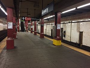
The station has three tracks and two island platforms. The fourth track, the former northbound express on the abandoned side, was removed in the aforementioned 2004 renovations.
Mosaics include the name tablet, "B," "newsstand," "Women," and "Men" in raised letters. A unique feature of the station is the arched wall niches at the north end, rather than the standard rectangular niches. The station featured a news-stand and restrooms, all of which have long been closed.

The station has two mezzanine areas on each side of Bowery. Only the eastern mezzanine is open today; the western mezzanine has long been closed, and stairways to it are blocked. The eastern mezzanine is reached via three flights of stairs or a single escalator from the open platform.
Provisions[]
The east end of the station has a high ceiling; this was to allow for a proposed subway to pass through it. This section had an opening in the wall separating both platforms to bracket the subway, but has been covered with plywood. At the curve between Bowery and Canal Street, there is a small provision for a line into Spring Street, for which no definite plan was ever provided. Due to the depth, there were escalators that were provided in the original construction, one on each platform running to the east mezzanine. The escalator on the south platform was either not installed or removed long ago.
Exits[]
Two exits go from the east mezzanine to either eastern corner of Delancey Street and Bowery. These are the only open entrances to the station.[14] The original exit from the east mezzanine led to the median of Delancey Street just east of Bowery; it has since been demolished and sealed.
In addition to the open exits, there are two exits from the closed west mezzanine that go to either western corner of Kenmare Street and Bowery from inside buildings. The exit to the northwestern corner was completely destroyed, while the exit to the southwestern corner was partly repurposed; part of the southwestern exit remains under MTA property as an emergency exit.[15] It is located immediately to the east of the 10 Kenmare Street storefront, behind a red red door.[13]
References[]
- ^ "Glossary". Second Avenue Subway Supplemental Draft Environmental Impact Statement (SDEIS) (PDF). Vol. 1. Metropolitan Transportation Authority. March 4, 2003. pp. 1–2. Archived from the original (PDF) on February 26, 2021. Retrieved January 1, 2021.
- ^ a b The New York Times, Passenger Killed on Loop's First Day, August 5, 1913, page 2
- ^ "Station Developers' Information". Metropolitan Transportation Authority. Retrieved June 13, 2017.
- ^ "Facts and Figures: Annual Subway Ridership 2014–2019". Metropolitan Transportation Authority. 2020. Retrieved May 26, 2020.
- ^ a b "Facts and Figures: Annual Subway Ridership 2014–2019". Metropolitan Transportation Authority. 2020. Retrieved May 26, 2020.
- ^ James Blaine Walker, Fifty Years of Rapid Transit, 1864–1917, published 1918, pp. 203–239
- ^ Engineering News, A New Subway Line for New York City, Volume 63, No. 10, March 10, 1910
- ^ Joseph Brennan, Abandoned Stations: Canal St platform, accessed April 18, 2007
- ^ Peter Dougherty, Tracks of the New York City Subway, Centennial Commemorative Edition 3.7a, 2004, page 65
- ^ Update, the MTA Plan for 2000–2004: Strategic Business Plan, Agency 2001 Operating Budgets, Financial Plan. The Authority. 2000.
- ^ Committee, New York City Transit Authority Transit (2006). Transit Committee Meeting. MTA New York City Transit Committee. pp. 95, 96.
- ^ "Capital Program 2000–2004 MTA New York City Transit". mta.info. Archived from the original on February 9, 2005. Retrieved November 12, 2017.
- ^ a b Fleming, Kirsten (2021-04-06). "This abandoned subway station is Hollywood's best-kept secret film set". New York Post. Retrieved 2021-04-21.
- ^ "MTA Neighborhood Maps: Lower East Side" (PDF). Metropolitan Transportation Authority. 2015. Retrieved August 6, 2015.
- ^ "Bowery".
External links[]
 Media related to Bowery (BMT Nassau Street Line) at Wikimedia Commons
- nycsubway.org – BMT Nassau Street Line: Bowery
- Station Reporter — J Train
- Bowery entrance from Google Maps Street View
- Platform from Google Maps Street View
- Abandoned Stations - Bowery
| Nassau St. Line | |
|---|---|
| |
- BMT Nassau Street Line stations
- New York City Subway stations in Manhattan
- New York City Subway stations located underground
- Railway stations in the United States opened in 1913
- Bowery
- Lower East Side
- 1913 establishments in New York City