Marcy Avenue station
Marcy Avenue | |||
|---|---|---|---|
 Manhattan-bound platform | |||
| Station statistics | |||
| Address | Marcy Avenue & Broadway Brooklyn, NY 11211 | ||
| Borough | Brooklyn | ||
| Locale | Williamsburg | ||
| Coordinates | 40°42′30″N 73°57′29″W / 40.708361°N 73.957944°WCoordinates: 40°42′30″N 73°57′29″W / 40.708361°N 73.957944°W | ||
| Division | B (BMT)[1] | ||
| Line | BMT Jamaica Line | ||
| Services | J M Z | ||
| Transit | ⛴ NYC Ferry: East River Route (at South Tenth Street west of Kent Avenue) | ||
| Structure | Elevated | ||
| Platforms | 2 side platforms | ||
| Tracks | 3 (2 in passenger service) | ||
| Other information | |||
| Opened | June 25, 1888[2] | ||
| Station code | 101[3] | ||
| Accessible | |||
| Opposite- direction transfer | No | ||
| Traffic | |||
| 2019 | 4,717,791[5] | ||
| Rank | 98 out of 424[5] | ||
| Station succession | |||
| Next east | Myrtle Avenue (express): J Hewes Street (local): J | ||
| Next west | Essex Street: J Driggs Avenue: no service; demolished | ||
| |||
| |||
| |||
| |||


Marcy Avenue is a station on the BMT Jamaica Line of the New York City Subway. Located at the intersection of Marcy Avenue and Broadway in Brooklyn, it is served by the J train at all times, the M train at all times except late nights, and the Z train during rush hours in the peak direction.
History[]

Marcy Avenue opened on June 25, 1888 as a part of the Broadway Elevated, one of the first elevated lines in New York City. Trains traveled westbound to the Broadway Ferry terminal on the East River in Brooklyn and eastbound services ran to Canarsie (this routing is no longer used due to the later building of the Canarsie Line) and a connection over the Williamsburg Bridge to Delancey Street/Essex Street in Manhattan opened in 1908.[6] In 1913, trains were extended farther down the newly opened Nassau Street Line to Chambers Street. A year later, a connection was built to allow Myrtle Avenue trains to run on the Broadway Elevated.
The Dual Contracts expansion projects radically changed operations at Marcy Avenue. A third track was added, allowing trains to run express, although the track remains as a stub-end at Marcy Avenue for storage and turn-arounds. The Contracts also provided for the merger of the Jamaica Line from Broadway Junction to 168th Street with the Broadway Elevated, in turn making the Broadway Elevated part of the Jamaica Line and giving trains three eastern terminals.
On April 13, 1954, the enlarged station platform at Marcy Avenue was opened, as well as the expanded stairway facilities.[7]
As part of the 2015–2019 Metropolitan Transportation Authority's Capital Program, station capacity enhancements will be made at the station. The project will assess the feasibility of widening and reconstructing the stairs at Havemeyer Street, widening the westerly outbound platform, and widening the platform level fare control areas to fit in an additional low-level turnstile. Design work started in April 2017 and will be finished in December 2017, with construction set to begin in April 2018.[8]
Station layout[]
| P Platform level |
Side platform | |
| Westbound[9] | ← ← ← | |
| Stub-end center track | No service | |
| Eastbound[9] | | |
| Side platform | ||
| G | Street level | Entrances/exits |

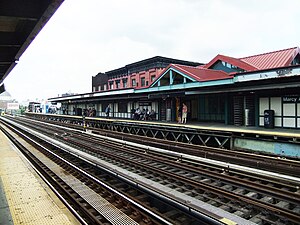
This station has two side platforms and three tracks and is the westernmost station on the Jamaica Line. The center track dead ends at the west end at a bumper block and is unusable for service. Both platforms have beige windscreens and red canopies with green frames that run along the entire length except for a section at the southeast (railroad south), where they have waist-high black steel fences. During the 1999 reconstruction of the Williamsburg Bridge, a temporary platform was erected over the center track for the station's use as a terminal station.
The 2005 artwork here is called A Space Odyssey by Ellsworth Ausby. It consists of stained glass windows depicting space travel on the platform windscreens.
Just west of this station, there is a short section of trackway continuing straight which once led to the Broadway Ferry Spur. As now configured, westbound trains run over the Williamsburg Bridge, connecting to the BMT Nassau Street Line in Manhattan. To the east, there are switches that are used to access the center express track, which is used by the J and Z trains in the peak direction weekday midday and rush hours.
Exits[]
All four fare control areas of the station are on platform level. As a result, there is no free transfer between directions. The primary ones, are elevated station houses adjacent to the platforms. Each station house has doors leading to the stairs and platform, turnstile bank, token booth, and two stairs and one ADA-accessible elevator to the street. The stairs from the Manhattan-bound station house go down to either northern corner of Marcy Avenue and Broadway while the stair from the Queens-bound station house go down to either southern corners.[10] The elevators go down to either western corner of Marcy Avenue and Broadway, with the Queens-bound elevator on the southwest corner and the Manhattan-bound elevator on the northwest corner.[11]
Both platforms have a HEET turnstile entrance/exit at their extreme west end that was added during a 1990s renovation. Each leads to a canopied staircase that goes down to either side of Broadway near Havemeyer Street.[10]
In popular culture[]

The home of the character Dave Stutler in the 2010 film The Sorcerer's Apprentice is located near this station. Stutler is also attacked by a wolf in this station.[citation needed]
The fictional neighborhood of "Little Wadiya", from the 2012 film The Dictator, is located near to this station. The choice may be related[12] to the presence of the Hasidic Jewish Community in Williamsburg.
Flight of the Conchords are seen emerging from Marcy Avenue station singing the song during season 1, episode 2 of their eponymous TV show.[citation needed]
References[]
- ^ "Glossary". Second Avenue Subway Supplemental Draft Environmental Impact Statement (SDEIS) (PDF). 1. Metropolitan Transportation Authority. March 4, 2003. pp. 1–2. Archived from the original (PDF) on February 26, 2021. Retrieved January 1, 2021.
- ^ "The Broadway Line Opened". Brooklyn Daily Eagle. Brooklyn, NY. June 25, 1888. p. 6.
- ^ "Station Developers' Information". Metropolitan Transportation Authority. Retrieved June 13, 2017.
- ^ "Facts and Figures: Annual Subway Ridership 2014–2019". Metropolitan Transportation Authority. 2020. Retrieved May 26, 2020.
- ^ Jump up to: a b "Facts and Figures: Annual Subway Ridership 2014–2019". Metropolitan Transportation Authority. 2020. Retrieved May 26, 2020.
- ^ 1912 BMT system map NYCSubway Retrieved August 10, 2009
- ^ Authority, New York City Transit (1953). Report.
- ^ "T7160519 Station Capacity Enhancements at Marcy Avenue on the Jamaica Line". web.mta.info. Metropolitan Transportation Authority. Retrieved September 3, 2017.
- ^ Jump up to: a b This is a wrong-way concurrency in railroad direction.
- ^ Jump up to: a b "MTA Neighborhood Maps: Williamsburg and Bedford Stuyvesant" (PDF). mta.info. Metropolitan Transportation Authority. 2018. Retrieved October 1, 2018.
- ^ "Accessible Stations in the MTA Network". web.mta.info. Metropolitan Transportation Authority. Retrieved November 29, 2016.
- ^ Genna Rivieccio aka Smoking Barrel (May 18, 2012). "The Dictator: Less of a Dick Than You Might Think". Behind the Hype. Retrieved June 26, 2012.
External links[]
| Wikimedia Commons has media related to Marcy Avenue (BMT Jamaica Line). |
- nycsubway.org – BMT Jamaica Line: Marcy Avenue
- Station Reporter — J Train
- Station Reporter — M Train
- The Subway Nut — Marcy Avenue Pictures
- MTA's Arts For Transit — Marcy Avenue (BMT Jamaica Line)
- Marcy Avenue entrance from Google Maps Street View
- Havemeyer Street entrance from Google Maps Street View
- Platforms from Google Maps Street View
- Accessible New York City Subway stations
- BMT Jamaica Line stations
- 1888 establishments in New York (state)
- New York City Subway stations in Brooklyn
- New York City Subway stations located aboveground
- Railway stations in the United States opened in 1888
- Williamsburg, Brooklyn