York Street station (IND Sixth Avenue Line)
York Street | |||||||||||||||||||||||||||||||||||||||||||||||||||||||||||||||||||||||||||||||||||||||||
|---|---|---|---|---|---|---|---|---|---|---|---|---|---|---|---|---|---|---|---|---|---|---|---|---|---|---|---|---|---|---|---|---|---|---|---|---|---|---|---|---|---|---|---|---|---|---|---|---|---|---|---|---|---|---|---|---|---|---|---|---|---|---|---|---|---|---|---|---|---|---|---|---|---|---|---|---|---|---|---|---|---|---|---|---|---|---|---|---|---|
 Station platform | |||||||||||||||||||||||||||||||||||||||||||||||||||||||||||||||||||||||||||||||||||||||||
| Station statistics | |||||||||||||||||||||||||||||||||||||||||||||||||||||||||||||||||||||||||||||||||||||||||
| Address | York Street & Jay Street Brooklyn, NY 11201 | ||||||||||||||||||||||||||||||||||||||||||||||||||||||||||||||||||||||||||||||||||||||||
| Borough | Brooklyn | ||||||||||||||||||||||||||||||||||||||||||||||||||||||||||||||||||||||||||||||||||||||||
| Locale | Dumbo | ||||||||||||||||||||||||||||||||||||||||||||||||||||||||||||||||||||||||||||||||||||||||
| Coordinates | 40°42′06″N 73°59′12″W / 40.701529°N 73.986783°WCoordinates: 40°42′06″N 73°59′12″W / 40.701529°N 73.986783°W | ||||||||||||||||||||||||||||||||||||||||||||||||||||||||||||||||||||||||||||||||||||||||
| Division | B (IND)[1] | ||||||||||||||||||||||||||||||||||||||||||||||||||||||||||||||||||||||||||||||||||||||||
| Line | IND Sixth Avenue Line | ||||||||||||||||||||||||||||||||||||||||||||||||||||||||||||||||||||||||||||||||||||||||
| Services | F | ||||||||||||||||||||||||||||||||||||||||||||||||||||||||||||||||||||||||||||||||||||||||
| Transit | ⛴ NYC Ferry: East River and South Brooklyn routes (at Old Fulton Street and Furman Street) | ||||||||||||||||||||||||||||||||||||||||||||||||||||||||||||||||||||||||||||||||||||||||
| Structure | Underground | ||||||||||||||||||||||||||||||||||||||||||||||||||||||||||||||||||||||||||||||||||||||||
| Platforms | 1 island platform | ||||||||||||||||||||||||||||||||||||||||||||||||||||||||||||||||||||||||||||||||||||||||
| Tracks | 2 | ||||||||||||||||||||||||||||||||||||||||||||||||||||||||||||||||||||||||||||||||||||||||
| Other information | |||||||||||||||||||||||||||||||||||||||||||||||||||||||||||||||||||||||||||||||||||||||||
| Opened | April 9, 1936 | ||||||||||||||||||||||||||||||||||||||||||||||||||||||||||||||||||||||||||||||||||||||||
| Station code | 235[2] | ||||||||||||||||||||||||||||||||||||||||||||||||||||||||||||||||||||||||||||||||||||||||
| Opposite- direction transfer | Yes | ||||||||||||||||||||||||||||||||||||||||||||||||||||||||||||||||||||||||||||||||||||||||
| Traffic | |||||||||||||||||||||||||||||||||||||||||||||||||||||||||||||||||||||||||||||||||||||||||
| 2019 | 3,927,129[4] | ||||||||||||||||||||||||||||||||||||||||||||||||||||||||||||||||||||||||||||||||||||||||
| Rank | 124 out of 424[4] | ||||||||||||||||||||||||||||||||||||||||||||||||||||||||||||||||||||||||||||||||||||||||
| Station succession | |||||||||||||||||||||||||||||||||||||||||||||||||||||||||||||||||||||||||||||||||||||||||
| Next north | East Broadway: F | ||||||||||||||||||||||||||||||||||||||||||||||||||||||||||||||||||||||||||||||||||||||||
| Next south | Jay Street–MetroTech: F | ||||||||||||||||||||||||||||||||||||||||||||||||||||||||||||||||||||||||||||||||||||||||
| |||||||||||||||||||||||||||||||||||||||||||||||||||||||||||||||||||||||||||||||||||||||||
| |||||||||||||||||||||||||||||||||||||||||||||||||||||||||||||||||||||||||||||||||||||||||
| |||||||||||||||||||||||||||||||||||||||||||||||||||||||||||||||||||||||||||||||||||||||||
| |||||||||||||||||||||||||||||||||||||||||||||||||||||||||||||||||||||||||||||||||||||||||


The York Street station is a station on the IND Sixth Avenue Line of the New York City Subway. It is served by the F train at all times and the <F> train during rush hours in the peak direction. It is located at York Street and Jay Street in Dumbo and is the only Sixth Avenue Line station in Brooklyn.
History[]
Background[]
More than 50 years before the construction of the IND Sixth Avenue Line, the intersection of York and Jay Streets was between two stations on the original BMT Lexington Avenue Line. West of the intersection was , which had a connection to the Brooklyn Bridge via the New York and Brooklyn Bridge Railway. One block east of the station was the . The line and the two stations ran west to east, were built by Brooklyn Elevated Railroad on May 13, 1885[5] and closed by Brooklyn Rapid Transit on April 11, 1904.[6]
Construction and opening[]
New York City mayor John Francis Hylan's original plans for the Independent Subway System (IND), proposed in 1922, included building over 100 miles (160 km) of new lines and taking over nearly 100 miles (160 km) of existing lines, which would compete with the IRT and the Brooklyn–Manhattan Transit Corporation (BMT), the two major subway operators of the time.[7][8] The IND Sixth Avenue Line was designed to replace the elevated IRT Sixth Avenue Line.[9] The first portion of the line to be constructed was then known as the Houston–Essex Street Line, which ran under Houston, Essex, and Rutgers Streets. The contract for the line was awarded to Corson Construction in January 1929,[10] and construction of this section officially started in May 1929.[11]
The York Street station opened on January 1, 1936, as the southern terminus of the first four stations to open on the Sixth Avenue Line. Two local tracks split from a junction with the Eighth Avenue Line south of West Fourth Street–Washington Square, running east under Houston Street and south under Essex Street to a temporary terminal at East Broadway.[12] The station was initially served by E trains to Church Avenue.[13][14] Just after midnight on April 9, 1936, trains began running under the East River via the Rutgers Street Tunnel, which connected the Houston-Essex Street Line with the north end of the Culver Line at a junction with the Eighth Avenue Line north of Jay Street–Borough Hall. E trains were sent through the connection to Church Avenue.[15][16] When further sections of the Sixth Avenue Line opened on December 15, 1940, the F train replaced the E train at the East Broadway station.[17]
Station layout[]
| G | Street level | Exit/entrance |
| B1 | Mezzanine | Fare control, station agent |
| B2 | Northbound | ← |
| Island platform | ||
| Southbound | | |
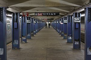
This underground, deep-level station has two tracks and one narrow island platform. Located at the southern end of the Rutgers Street Tunnel, it has round deep-bore walls with matte-finish white brick tiling and purple tile border; this tiling scheme is also present on the large, circular platform columns at the center of the station. The standard I-beam columns are painted blue with alternating ones having black name plates in white lettering.
To the north of the station, the Sixth Avenue Line continues via the Rutgers Street Tunnel to Manhattan; to the south, it converges with the IND Eighth Avenue Line and ends north of Jay Street. The Sixth Avenue Line tracks continue south as the IND Culver Line.[18]
Exit[]

The only exit, located at the station's north end, leads to the Rutgers Street tunnel ventilation tower at the intersection of York Street and Jay Street. It has a turnstile bank and long passageway and staircase to the platform.[19]
There were proposals for a mezzanine at the station's south end. This mezzanine would have had an entrance leading to the intersection of High Street and Jay Street. The entrance was never built. In 2016, Delson or Sherman Architects proposed a new accessible entrance at the south end of the York Street station, as well as station upgrades, but these have yet to receive any official support.[20]
Points of interest[]
References[]
- ^ "Glossary". Second Avenue Subway Supplemental Draft Environmental Impact Statement (SDEIS) (PDF). Vol. 1. Metropolitan Transportation Authority. March 4, 2003. pp. 1–2. Archived from the original (PDF) on February 26, 2021. Retrieved January 1, 2021.
- ^ "Station Developers' Information". Metropolitan Transportation Authority. Retrieved June 13, 2017.
- ^ "Facts and Figures: Annual Subway Ridership 2014–2019". Metropolitan Transportation Authority. 2020. Retrieved May 26, 2020.
- ^ a b "Facts and Figures: Annual Subway Ridership 2014–2019". Metropolitan Transportation Authority. 2020. Retrieved May 26, 2020.
- ^ "Done at Last". Brooklyn Daily Eagle. Brooklyn, NY. May 13, 1885. p. 1.
- ^ "www.nycsubway.org". www.nycsubway.org.
- ^ "Two Subway Routes Adopted by City". The New York Times. August 4, 1923. p. 9. ISSN 0362-4331. Retrieved August 1, 2019.
- ^ "Plans Now Ready to Start Subways". The New York Times. March 12, 1924. p. 1. ISSN 0362-4331. Retrieved August 1, 2019.
- ^ "Delaney For Razing Elevated Line Now; Work in 6th Av. Could Begin in Six Months if Condemnation Started at Once, He Says. Sees Cut In Subway Cost Eliminating Need for Underpinning Would Save $4,000,000 and Speed Construction, He Holds". The New York Times. January 11, 1930. ISSN 0362-4331. Retrieved April 27, 2018.
- ^ "East Side Subway Will Evict 10,000; Work on New Line, Likely to Begin in May, Will Force Many Tenants to Move. 200 Buildings Will Fall Transportation Board Notifies Property Owners—Condemnation to Coat Over $11,000,000. Expect Work to Start in May. Residents Recall Other Days". The New York Times. February 24, 1929. ISSN 0362-4331. Retrieved April 28, 2018.
- ^ "East Side Subway Started By Mayor; He Breaks Ground for Crosstown System at Second Av. and East Houston St. Miller Hails Project Sees Area Rejuvenated by Line and City's Plan to Raze Old Tenements". The New York Times. May 2, 1929. ISSN 0362-4331. Retrieved April 28, 2018.
- ^ "LaGuardia Opens New Subway Link". The New York Times. January 2, 1936. p. 1. ISSN 0362-4331. Retrieved October 7, 2011.
- ^ "Two Subway Links Start Wednesday". The New York Times. April 6, 1936. p. 23. ISSN 0362-4331. Retrieved October 7, 2011.
- ^ "New Subway Link Opened by Mayor". The New York Times. April 9, 1936. p. 23. ISSN 0362-4331. Retrieved October 7, 2011.
- ^ "Two Subway Links Start Wednesday". The New York Times. April 6, 1936. p. 23. ISSN 0362-4331. Retrieved October 7, 2011.
- ^ "New Subway Link Opened by Mayor". The New York Times. April 9, 1936. p. 23. ISSN 0362-4331. Retrieved October 7, 2011.
- ^ "The New Subway Routes". The New York Times. December 15, 1940. ISSN 0362-4331. Retrieved April 15, 2018.
- ^ Dougherty, Peter (2020). Tracks of the New York City Subway 2020 (16th ed.). Dougherty. OCLC 1056711733.
- ^ a b c d e "MTA Neighborhood Maps: Downtown Brooklyn and Borough Hall" (PDF). mta.info. Metropolitan Transportation Authority. 2015. Retrieved August 2, 2015.
- ^ "F yeah! Architect designs second York Street subway exit". Brooklyn Paper. September 24, 2016. Retrieved October 25, 2019.
- For the plan, see: "A new design and a second entrance for the York Street subway station". DELSON OR SHERMAN ARCHITECTS PC. Retrieved October 25, 2019.
External links[]
| Wikimedia Commons has media related to York Street (IND Sixth Avenue Line). |
- nycsubway.org – IND 6th Avenue: York Street
- Station Reporter — F Train
- The Subway Nut — York Street Pictures
- York Street entrance from Google Maps Street View
- Platform from Google Maps Street View
| Sixth Ave. Line |
| ||||
|---|---|---|---|---|---|
| |||||
- IND Sixth Avenue Line stations
- New York City Subway stations in Brooklyn
- New York City Subway stations located underground
- Railway stations in the United States opened in 1936
- 1936 establishments in New York City
- Brooklyn Heights