Manhattan Bridge
Manhattan Bridge | |
|---|---|
 Seen from Brooklyn in July 2017 | |
| Coordinates | 40°42′25″N 73°59′26″W / 40.7070°N 73.9905°WCoordinates: 40°42′25″N 73°59′26″W / 40.7070°N 73.9905°W |
| Carries | 7 lanes of roadway, 4 tracks of the |
| Crosses | East River |
| Locale | New York City (Manhattan-Brooklyn) |
| Maintained by | New York City Department of Transportation |
| ID number | 2240028 (upper) 2240027 (lower)[1] |
| Characteristics | |
| Design | Suspension bridge |
| Total length | 6,855 ft (2,089 m) |
| Width | 120 feet (37 m)[2] |
| Height | 336 ft (102 m) (towers)[2] |
| Longest span | 1,480 feet (451 m)[3] |
| Clearance below | 135 ft (41.1 m)[2] |
| History | |
| Designer | Leon Solomon Moisseiff[2] |
| Constructed by | Othniel Foster Nichols[2] |
| Construction start | 1901[2] |
| Construction end | 1909[4] |
| Opened | December 31, 1909[4] |
| Statistics | |
| Daily traffic | 85,084 (2016)[5] |
| Toll | Free both ways |
| Designated | August 30, 1983 |
| Reference no. | 83001694[6] |
| Designated entity | Manhattan Bridge |
New York City Landmark | |
| Designated | November 25, 1975 |
| Reference no. | 0899 |
| Designated entity | Manhattan Bridge Arch and Colonnade |
| Location | |
 | |

The Manhattan Bridge is a suspension bridge that crosses the East River in New York City, connecting Lower Manhattan at Canal Street with Downtown Brooklyn at the Flatbush Avenue Extension. The main span is 1,480 ft (451 m) long, with the suspension cables being 3,224 ft (983 m) long. The bridge's total length is 6,855 ft (2,089 m). It is one of four toll-free vehicular bridges connecting Manhattan Island to Long Island; the nearby Brooklyn Bridge is just slightly further downtown, while the Queensboro and Williamsburg bridges are to the north.
The bridge was designed by Leon Moisseiff,[2] built by The Phoenix Bridge Company, and opened to traffic on December 31, 1909. An innovative design, it was the first suspension bridge to employ Josef Melan's deflection theory for deck stiffening, resulting in the first use of a lightly-webbed weight-saving Warren truss[7] for its construction. Considered the forerunner of modern suspension bridges, it served as the model for many of the record-breaking spans built in the first half of the twentieth century.
History[]
The bridge was the last of the three suspension spans built across the lower East River, following the Brooklyn and Williamsburg Bridges. In the earliest plans it was to have been called "Bridge No. 3", but was given the name Manhattan Bridge in 1902.[8] When the name was confirmed in 1904, The New York Times criticized it as "meaningless", lobbied for one after Brooklyn's Wallabout Bay, and railed that the span "would have geographical and historical significance if it were known as the Wallabout Bridge".[9] In 1905, the Times renewed its campaign, stating, "All bridges across the East River are Manhattan bridges. When there was only one, it was well enough to call it the Brooklyn Bridge, or the East River Bridge".[10]
Planning and construction[]
Planning and initial work[]
The earliest plans for what became the Manhattan Bridge were designed by R. S. Buck.[11][12]:548 These plans called for a suspension bridge with carbon steel wire cables and a suspended stiffening truss, supported by a pair of towers with eight braced legs. This design would have consisted of a main span of 1,470 feet (450 m) and approaches of 725 feet (221 m) each.[13] Construction on the foundations for the suspension towers had commenced by at least 1901.[14] A plan for the suspension bridge was announced in 1903. Elevated and trolley routes would use the Manhattan Bridge, and there would be large balconies and enormous spaces within the towers' anchorages.[15] By 1903, three workers had died while working on the Brooklyn-side tower's caisson.[16] A $10 million grant for the bridge's construction was granted in May 1904 with the expectation that work on the bridge would start later that year.[17]
The raised objections to one of the bridge's plans in June 1904, which delayed the start of construction for the span.[18] Another set of plans was unveiled that month by New York City Bridge Commissioner Gustav Lindenthal, in conjunction with Henry Hornbostel.[19] The proposal also called for each of the suspension towers to be made of four columns, to be braced transversely and hinged to the bottom of the abutments longitudinally. The same span dimensions from Buck's plan were used because work on the masonry pier foundations had already begun.[13] Additionally, the towers would have contained Modern French detail, while the anchorages would have been used for functions such as meeting halls.[11]
Lindenthal's plan was also rejected,[20] over a dispute which revolved around whether his plan using eyebars was better than the more established practice of using wire cables.[21] The MAC voted to use wire cables in the bridge in September 1904.[22] Lindenthal was ultimately dismissed and a new design was commissioned from Leon Moisseiff.[2][11] Lindenthal was also replaced by George Best as bridge commissioner.[11][23] Hornbostel was replaced by Carrère and Hastings as architectural consultants.[24] Because of this dispute, the plans for Manhattan Bridge are sometimes mistakenly attributed to Lindenthal.[25] Other delays arose over the proposed placement of the bridge's termini on either side.[26]
Subsequent construction[]
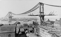
The first temporary wire between the Manhattan Bridge's two towers was strung in June 1908. It was to be replaced later with two sets of permanent, thicker main cables, each 21.5 inches (55 cm) thick, in pairs on both sides of the bridge's deck. By this time, the construction cost had increased to $22 million.[27] During the stringing of the anchorages, one of the cables on the Brooklyn side broke loose, injuring two people.[28][29] The last of the suspender ropes supporting the main cables was strung in December of that year. The cables had been strung in four months,[30] The construction of the bridge span required 30,000 tons of steel.[31] Erection of the superstructure and steel fabrication were contracted to The Phoenix Bridge Company.[32][33] The first girder for the new bridge was installed in February 1909.[34] By April, the majority of the span had been fitted into place between the main cables.[35]
The recommended the construction of a subway line across the Manhattan Bridge in 1905.[36] This line was approved in 1907.[37] The New York City Public Service Commission requested permission to start constructing the subway tracks in March 1908.[38] This plan was approved in May.[39]
Opening and early history[]
A group of 100 "leading citizens of Brooklyn" walked over the bridge on December 5, 1909, marking the unofficial completion of the bridge.[40] The bridge was officially opened by outgoing Mayor George B. McClellan Jr. on December 31, 1909.[4] Shortly after opening, a fire on the Brooklyn side of the Manhattan Bridge damaged the structure.[41]
In 1910, the year after the bridge opened, Carrère and Hastings drew up preliminary plans for an elaborate Greek Revival grand entry to the bridge on the Manhattan side as part of the "City Beautiful" movement (see § Arch and colonnade), as well as a smaller approach on the Brooklyn side. These approaches would hide the bridge.[42] Construction began that year, and plans were finalized in 1912. A plot of 400 by 750 feet (120 by 230 m), bounded by the Bowery and Canal, Forsyth, and Bayard Streets, was cleared for the arch and colonnade's construction.[43][44] The arch and colonnade were completed in 1915,[45] while a pair of pylons on the Brooklyn side were installed in November 1916.[42][46]

An upper-deck roadway on the bridge was installed in 1922.[47] The bridge was the subject of American artist Edward Hopper's 1928 painting Manhattan Bridge Loop.[48]
Floodlights and barbed-wire fences were installed at the bases of the bridge's anchorages in 1951, during the Cold War. The installations were fortified to protect against "possible sabotage attempts under wartime conditions". The anchorages themselves were sealed.[29][49] The pylons on the Brooklyn side were removed in 1963 to accommodate a widened roadway, and they were moved to the Brooklyn Museum.[46]
Reconstruction[]
The subway trains crossing the Manhattan Bridge had a major impact on its condition (see § Trackage history), and the bridge started to tilt to one side based on how many trains used that side. This had supposedly been a problem since the tracks opened in 1917.[29][50] In 1956, the bridge was renovated in order to rectify this tilt.[51] However, by 1978, the Manhattan Bridge had deteriorated to such a point that the United States Congress voted to allocate money to repair the bridge, as well as several others in New York City.[52] Minor repair work started in 1982.[53] A discretionary grant for $50 million was allocated to these bridges' repairs in 1985.[54] The first phase of repairs started that year.[55] The bridge's condition was blamed on the imbalance in the number of trains crossing the bridge, as well as deferred maintenance during the New York City fiscal crisis of the 1970s.[50]
In April 1986, workers temporarily closed the Manhattan-bound roadway on the upper level in order to repair the deck there.[56] The north-side subway tracks, underneath the Manhattan-bound roadway, were also closed during this time.[57] In December 1987, inspectors also shut one lane of the lower level due to a crack in the deck.[58] The New York City Department of Transportation published a list of 17 structurally deficient bridges in the city. Among them was the Manhattan Bridge, which needed $166 million in repairs to fix "cable anchors and torsion of steel members as subways cross".[59] Repairs on the northern side of the Manhattan Bridge were complete by the end of 1988,[55] and the subway tracks on the north side were reopened. Simultaneous with the reopening of the north side, the south-side tracks were closed.[60] In 1991, trucks were banned from the lower level because they were too heavy for the decaying bridge.[61]
Major repair work on the southern side began in 1992.[55] The Yonkers Construction Company was awarded a $97.8 million contract for the repair project in August 1992.[62] City Comptroller Elizabeth Holtzman originally denied the contract to the company because of concerns about corruption,[63] but she was overridden by Mayor David Dinkins, who wanted to complete repairs quickly.[62] At the same time, the NYCDOT increased the frequency of maintenance inspections for the bridge, after inspectors found holes in beams that had been deemed structurally sound during previous inspections.[64] The Brooklyn-bound roadway on the upper level was closed from 1993 to 1996 so that side of the bridge could be repaired.[65] The bridge repairs were repeatedly delayed as the renovation process uncovered more serious structural problems underlying the bridge. The original plans had been to complete the renovations by 1995 for $150 million, but by 1996, the renovation was slated to be complete in 2003 at a cost of $452 million.[53] By 2001, it was estimated that the total cost of the renovations had reached half a billion dollars, including $260 million for the south side and another $175 million for the north side. At the time, the NYCDOT had set a January 2004 deadline for the renovation.[66]
The arch and colonnade had also become deteriorated, having become covered with graffiti and dirt. The enclosed plaza within the colonnade had been used as a parking lot by the New York City Police Department, while the only remaining portion of the large park surrounding the arch and colonnade, at Canal and Forsyth Streets, had accumulated trees. The arch and colonnade themselves had open joints in the stonework, as well as weeds, bushes, and small trees growing at their top.[43] The arch and colonnade were restored starting in the late 1990s, with the restoration being completed in April 2001 for $11 million. The project entailed cleaning the structures and installing 258 floodlights.[67]
21st century[]
The original pedestrian walkway on the south side of the bridge was reopened after forty years in June 2001.[68] It was shared with bicycles until late summer 2004, when a dedicated bicycle path was opened on the north side of the bridge. The northern bridge bike path is notable for poor signage that leads to cyclist and pedestrian conflicts.[69] By the time work on the bridge was completed in 2004, the final cost of the renovation totaled $800 million.[29] The lower-level roadway was then renovated between 2004 and 2008.[70]
To celebrate the bridge's centennial, a series of events and exhibits were organized by the New York City Bridge Centennial Commission in October 2009. These included a ceremonial parade across the Manhattan Bridge on the morning of October 4 and a fireworks display in the evening.[71] In 2009, the bridge was designated as a National Historic Civil Engineering Landmark by the American Society of Civil Engineers.[7]
An $834 million project to replace the Manhattan Bridge's suspension cable was announced in 2010. The work was scheduled to take two years.[72] In late 2018, after rubble was found in Brooklyn Bridge Park under the Brooklyn approach, Skanska was given a contract to repair parts of the Manhattan Bridge at a cost of $75.9 million. The renovation was scheduled to finish in early 2021. The work entailed replacing some fencing, installing some new steel beams on the spans, and refurbishing ornamental elements on the towers.[73][74] For instance, the spherical finials atop the suspension towers were replaced with cast-iron copies.[75]
Description[]

The Manhattan Bridge has four vehicle lanes on the upper level, split between two roadways carrying opposite directions of traffic. The lower level has three reversible vehicle lanes, four subway tracks, two under each of the upper roadways; a walkway on the west; and a bikeway on the east. The bridge once carried New York State Route 27 and later was planned to carry Interstate 478.[76]
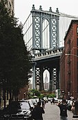
The main span between the two suspension towers is 1,470 or 1,480 feet (450 or 450 m) long and 160 feet (49 m) wide.[3][77] Including approach spans, the bridge is about 6,375 feet (1,943 m) long.[77] Navigational clearance is 134 ft (40.8 m) above mean high water (MHW).[78]
Both of the steel suspension towers contain little decorative detail, except for spherical finials, and rest on masonry piers.[77] Each suspension tower contains an iron and copper hood over the pedestrian or bike path on either side, as well as iron cornices just below the tops of the towers.[79] The Manhattan Bridge contains four main cables, which descend from the tops of the suspension towers and help support the deck.[77] The cables are attached to stone suspension anchorages on each side, measuring 225 feet (69 m) long and 175 feet (53 m) wide, with a pedestrian area 120 feet (37 m) high. The anchorages were made wider than the main or approach spans to give pedestrians a place to rest.[80] Each anchorage is designed with a colonnade on either side, beneath which is a large arch. These are the only portions of the anchorage that are decorated.[81]
Approach plazas[]
Carrère and Hastings designed approach plazas on both ends of the bridge. At the time of the bridge's opening, these plazas were meant to conceal views of the Manhattan Bridge from the streets on either end.[42][77]
Arch and colonnade[]

The arch and colonnade on the Manhattan end of the bridge were completed in 1915.[45] They surround an elliptical plaza facing northwest toward the Bowery.[44] The arch was based on Paris's Porte Saint-Denis while the colonnade and enclosing plaza was modeled after the one surrounding St. Peter's Square in Vatican City.[42][43][77] The design was chosen because the Manhattan Bridge continued as Flatbush Avenue on the Brooklyn side, which ran south to the Atlantic Ocean, and so the arch signified the Manhattan Bridge's role as an ocean "gateway". The plaza was influenced by the New York Improvement Plan of 1907, which sought to create plazas and other open spaces at large intersections; a massive circular plaza was ultimately supposed to connect the Brooklyn and Manhattan Bridges, but was never built.[82]
The Manhattan Bridge arch is one of the city's three remaining triumphal arches, the others being the Washington Square Arch and the Soldiers' and Sailors' Arch. Its opening measures 36 feet (11 m) high and 40 feet (12 m) wide.[82][44][77] The interior of the arch contains a coffered ceiling.[77] There are rosettes on the arch's soffit. The southern side of the arch, facing Brooklyn, is less decorated but has rusticated stone blocks indicative of a Parisian or Florentine bank.[43] The colonnade is elliptical and rises to 38 feet (12 m), supported by six pairs of 31-foot (9.4 m) Tuscan columns on either side, with each pair of columns flanking rusticated piers inside the colonnade. There is an entablature above the columns, as well as a cornice and balustrade at the top of the colonnade.[83][44][77] The decoration includes groups of allegorical sculptures sculpted by Carl Augustus Heber and a frieze called "Buffalo Hunt" by Charles Cary Rumsey.[82][43][45] The stonework of the arch and colonnade is made of white, fine-grained granite.[44] The arch and colonnade were initially bordered by granite retaining walls that contained decorative balustrades surrounding parkland on either side of the arch and colonnade.[43][44] Only a small segment of parkland remains at Canal and Forsyth Streets, while the south side of the park became Confucius Plaza.[43]
American Architect and Architecture described the arch and colonnade in 1912 as "worthy of one of the principal gateways of a great modern city".[44] The arch and colonnade were described as a "complete, dignified and monumental ensemble, worthy of one of the principal gateways of a great modern city" in a New York Times article.[43] From the bridge's completion, the arch was highly used by vehicular traffic.[84] Part of the colonnade's eastern arm was removed and replaced in the 1970s for the construction of the incomplete Second Avenue Subway.[85][83] The arch and colonnade were designated a New York City landmark on November 25, 1975.[86] After many years of neglect and several attempts by traffic engineers to remove the structure (including a proposal for the unbuilt Lower Manhattan Expressway that would have required removing the arch), the arch and colonnade were repaired and restored in 2000.[45][87]
Pylons in Brooklyn[]

Daniel Chester French designed two 12-foot-high (3.7 m), 20-short-ton (18-long-ton; 18 t) pylons named "Brooklyn" and "Manhattan" on the Brooklyn side of the Manhattan Bridge. These were installed in November 1916.[42][46][77] The pylons on the Brooklyn side were relocated to the Brooklyn Museum in 1963.[46] The pylons never constituted a true portal, even when they were in place. Following their removal, the Brooklyn approach did not contain a formal entrance.[77]
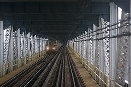
Subway tracks[]
Four subway tracks are located on the lower deck of the bridge, two on each side of the roadway. The two tracks on the south side are used by the Q train at all times and the N train at all times except late nights, when they use the Montague Street Tunnel. The tracks on the north side are used by the D train at all times and the B train on weekdays. On the Manhattan side, the south side tracks connect to Canal Street and become the express tracks of the BMT Broadway Line, while the north side tracks connect to the Chrystie Street Connection through Grand Street and become the express tracks on the IND Sixth Avenue Line. On the Brooklyn side, the two pairs merge under Flatbush Avenue to a large junction with the BMT Fourth Avenue Line and BMT Brighton Line at DeKalb Avenue. For 18 years, between 1986 and 2004, one or the other set of tracks was closed to repair structural damage.[88]
The feeder lines for the Brooklyn side of the tracks have not changed since subway service began on the bridge. It has always been fed by tracks from the BMT Fourth Avenue Line and the BMT Brighton Line, although the junction between the lines was reconstructed starting in 1956.[89][90] On the Manhattan side, however, the two north tracks originally connected to the BMT Broadway Line (where the south tracks now connect) while the two south tracks curved south to join the BMT Nassau Street Line towards Chambers Street.[91] As a result of the Chrystie Street Connection, which linked the north tracks to the Sixth Avenue Line upon completion in 1967,[92] the Nassau Street connection was severed.[91]
Trackage history[]
When the bridge first opened, its tracks did not connect to any others. In 1910, the Manhattan Bridge Three Cent Line, a streetcar company, began operations on those tracks.[93] This was followed by the Brooklyn and North River Line in 1912.[94] The trolley arrangement continued until 1915 when the subway tracks of the BRT (later BMT), which also had two tracks each over the Brooklyn and Williamsburg Bridges, was connected to the bridge.[95] The trolleys were moved to the upper-level roadways until 1929, when service was discontinued.[96] In the bridge's early years, the design was intended to contain four BRT subway tracks on the lower level, as well as two trolley and two elevated railway tracks on the upper level. The trolley tracks were carried around the Manhattan side's colonnade, while the subway tracks did not emerge from street level until south of the colonnade.[44][84]
The subway tracks on the Manhattan Bridge opened on June 22, 1915, along with the Fourth Avenue Line and the Sea Beach Line to Coney Island–Stillwell Avenue station.[97] The north tracks carried Fourth Avenue and, later, Brighton trains that continued to Midtown Manhattan via the Broadway Line. The south tracks carried Sea Beach trains that terminated at Chambers Street, initially the only stop on the Manhattan side of the bridge.[98] The Nassau Street Loop opened on May 29, 1931, extending the Nassau Street Line southward to the Montague Street Tunnel with two stations at Fulton Street and Broad Street.[99] Service on that side became relatively low afterward as the only trains that normally crossed it were The Bankers’ Special, which ran from either the Sea Beach and/or Fourth Avenue Line, crossed the Manhattan Bridge or Montague Street Tunnel into Manhattan, and then returned to Brooklyn via the opposite crossing.[citation needed]
Since the tracks are on the outer part of the bridge, passing trains caused the structure to tilt and sway. The wobble worsened as train cars became longer and heavier. Eventually, when one train moved over the bridge one side would be three feet lower than the other side, severely damaging the structure. In 1956, a repair program was begun at a cost of $30 million. Trains still crossed the bridge, but many times one of the tracks had to be closed with both routes using a single-track, which further restricted the number and size of the trains crossing.[51] Concurrent with the completion of the Chrystie Street Connection (opened November 26, 1967) to connect to the north tracks, the south tracks were rerouted to the Broadway Line, while the Nassau Line was disconnected from the bridge. The connection and its related projects added express service on the IND Sixth Avenue Line. The Sixth Avenue B and D trains were routed via the north side of the bridge, while the N and Q routes were moved to the south side of the bridge for service to Broadway. At the time, the B train continued to Brooklyn using the BMT West End Line, while the D and Q trains used the Brighton Line and the N used the BMT Sea Beach Line.[100]
Even after the 1956 repairs, the New York City Department of Transportation failed to maintain the bridge properly, and a major repair program began in the 1980s (see also § Later history). Changes to subway service patterns started in 1983.[101] Because of the large scope of these repairs, there was limited train access to the bridge, reducing the number of trains that could cross the span. The north tracks, which had been more heavily used, were closed first in April 1986. This split B and D service into two sections: trains from the Bronx and upper Manhattan terminated at 34th Street–Herald Square station, thus suspending express service on Sixth Avenue, while trains from Brooklyn were rerouted to the BMT Broadway Line express via the south side of the bridge. The N was rerouted via the Montague Street Tunnel.[57]
The north tracks were reopened and the south tracks were closed simultaneously in December 1988, merging the B and D services, rerouting the Q train to Sixth Avenue in Manhattan. Broadway Line express service was suspended while Sixth Avenue express service was restored.[60] After an 18-month delay for procuring contracts, the New York City Transit Authority and politicians pressured the DOT to resume N train service on the bridge's south side on September 30, 1990, despite warnings from engineers that the structure was unsafe and major repairs still had to be made.[102][103] On December 27, state inspectors forced south side service to be rerouted via the tunnel again after discovery of corroded support beams and missing steel plates.[102] The city's deputy commissioner for bridges and his administrative assistant were fired after this incident. Following the controversial decision to do so, the New York City Council's Transportation committee held an inquiry into the decision to restore subway service on the Manhattan Bridge's south side, as well as an inquiry into the safety of all New York City bridges.[103][104][105][106] They found that the Transportation Department and Transit Authority's lack of cooperative inspection were a major contributor for the deteriorating conditions.[107][108][50]
A projection for a reopening date was initially made for 1995.[109] That year, the north side was closed during off-peak hours for six months, rerouting the Q to Broadway and cutting D service from Brooklyn and B service from Manhattan. The south side finally reopened on July 22, 2001, whereby the north side was again closed, returning the Q to the express tracks on the Broadway Line; introducing the new W train to run on the West End Line; and cutting B and D service from Brooklyn. The south side was closed on weekends from April to November 2003, and the Q was rerouted via the Montague Street Tunnel.[110] On February 22, 2004, the north side reopened, and all four tracks were in service simultaneously for the first time in 18 years. B and D trains returned to Brooklyn, but switched routes in that borough (the B on the Brighton Line and D on the Fourth Avenue and West End Lines). Additionally, daytime N trains once again used the bridge for travel and the W train service in Brooklyn was discontinued.[111][112][113]
Between August 2, 2013, and September 14, 2014, weekend R trains and late-night N trains also used the south tracks due to the Montague Street Tunnel being closed for Hurricane Sandy-related repairs.[114]
Tracks used[]
|
1967–1986
1986–1988: North tracks closed
1988–2001: South tracks closed
|
2001–2004: North tracks closed
2013–2014: Montague Street Tunnel closed
2004–2013: 2014–Present
| |||||||||||||||||||||||||||||||||||||||||||||||||||||||||||||||||||||||||||||||||||||||||||||||||||||||||||||||||||||||||||||||||||||||||||||||||
Exits and entrances[]
Access to the Manhattan Bridge is provided by a series of ramps on both the Manhattan and Brooklyn sides of the river.
| Borough | Location | mi[115] | km | Destinations | Notes |
|---|---|---|---|---|---|
| Brooklyn | Brooklyn Heights | 0.0 | 0.0 | Flatbush Avenue Extension | Continuation south |
| 0.1 | 0.16 | Nassau Street | Northbound upper level entrance and southbound upper level exit | ||
| 0.2 | 0.32 | Northbound upper level entrance only | |||
| 0.2 | 0.32 | Jay Street to | Southbound upper level exit only | ||
| East River | 0.4– 1.0 | 0.64– 1.6 | Suspension span | ||
| Manhattan | Chinatown | 1.3 | 2.1 | Bowery | Slip ramp from northbound Bowery to northbound upper level |
| 1.4 | 2.3 | Bowery and Canal Street to | Northbound lower level exit and southbound upper level entrance; at-grade intersection | ||
| Chrystie Street to | Continuation of northbound upper level | ||||
| 1.000 mi = 1.609 km; 1.000 km = 0.621 mi | |||||
Proposed I-478 designation[]
As part of the construction of the Lower Manhattan Expressway, there were plans to make the Manhattan Bridge I-178, but since this interstate would have led to a crosstown expressway and the existing Brooklyn-Queens Expressway, the FHWA stated that the first digit should be even, so the designation I-478 was chosen.[116] However, with the cancellation of I-78 through New York City, the spur neither qualified to be part of the Interstate Highway System nor connected to any existing highways (though ramps directly from I-278 (Brooklyn-Queens Expressway) are accessible on the Brooklyn side). A fragment of the never-built expressway's onramp still exists above the Manhattan side of the bridge's center roadway.[117]

Gallery[]
View from Washington Street, Brooklyn

Cross section of the bridge

Manhattan-bound lower level

One of the pedestrian walkways

Manhattan bikeway


See also[]
- List of bridges and tunnels in New York City
- List of New York City Designated Landmarks in Manhattan below 14th Street
- National Register of Historic Places listings in Brooklyn
- National Register of Historic Places listings in Manhattan below 14th Street
References[]
Citations[]
- ^ http://www.nyc.gov/html/dot/downloads/pdf/dot_bridgereport15.pdf[bare URL]
- ^ Jump up to: a b c d e f g h Manhattan Bridge at Structurae
- ^ Jump up to: a b Jackson, Donald C. (1988). Great American Bridges and Dams. Wiley. p. 136. ISBN 0-471-14385-5.
- ^ Jump up to: a b c "Manhattan Bridge Opened to Traffic – Mayor McClellan's Last Act in Public Was to Lead a Procession on Wheels Across – Brooklyn Men Celebrate – New Structure Has the Largest Carrying Capacity of Any Crossing the River – The Span Is 1,470 Feet" (PDF). The New York Times. January 1, 1910. ISSN 0362-4331. Retrieved December 24, 2017.
- ^ "New York City Bridge Traffic Volumes" (PDF). New York City Department of Transportation. 2016. p. 9. Retrieved March 16, 2018.
- ^ "National Register Information System". National Register of Historic Places. National Park Service. November 2, 2013.
- ^ Jump up to: a b American Society of Civil Engineers Metropolitan Section (2016). "Manhattan Bridge". Historic Landmarks. New York City: American Society of Civil Engineers Metropolitan Section. Retrieved November 12, 2016.
- ^ "Aldermen's Lively War – New East River Bridges Named by the Board ��� Commissioner Woodbury Attacked and His Resolution for a Brooklyn Deputy Lost – The Chairman Denounced" (PDF). The New York Times. March 19, 1902. ISSN 0362-4331. Retrieved December 23, 2017.
- ^ "Manhattan Bridge" (PDF). The New York Times. June 19, 1904. ISSN 0362-4331. Retrieved December 23, 2017.
- ^ "Manhattan Bridge" (PDF). The New York Times. December 9, 1905. ISSN 0362-4331. Retrieved December 23, 2017.
- ^ Jump up to: a b c d Stern, Gilmartin & Massengale 1983, p. 51.
- ^ "The New Manhattan Bridge; A Bridge Beautiful As Well As Useful". Architects' and Builder's Magazine. 36 (12): 547–554. September 1904.
- ^ Jump up to: a b Architects' and Builders' Magazine 1904, p. 548.
- ^ "Bids On Bridge No. 3. – All the Propositions for Building Tower Foundations Will Be Rejected" (PDF). The New York Times. March 26, 1901. ISSN 0362-4331. Retrieved December 23, 2017.
- ^ "Plans for Third Bridge – The Manhattan to be Ornamental as Well as Useful – Halls in Anchorages to be Larger Than Cooper Union Auditorium – Globular Lights on High Pinnacles" (PDF). The New York Times. February 4, 1903. ISSN 0362-4331. Retrieved December 24, 2017.
- ^ "Work in the Caisson of Third East River Bridge – Death of Three Laborers Employed in Making Foundations for the Brooklyn Tower Causes Contractors to Desist from Their Attempt to Reach the Actual Rock Bottom" (PDF). The New York Times. February 22, 1903. ISSN 0362-4331. Retrieved December 24, 2017.
- ^ "Grants $10,000,000 for World's Biggest Bridge – Board of Estimate Authorizes Expenditure for Manhattan Span – Aldermen Will Act Next Week – Work on Superstructure Will Begin July 1 – Will Be Finished in 1909 – Most Capacious Bridge on Earth" (PDF). The New York Times. May 7, 1904. ISSN 0362-4331. Retrieved December 24, 2017.
- ^ "Manhattan Bridge" (PDF). The New York Times. June 25, 1904. ISSN 0362-4331. Retrieved December 23, 2017.
- ^ "Manhattan Bridge Plans – Lindenthal Design Promises Structure of Lasting Credit to City (letter)" (PDF). The New York Times. June 30, 1904. ISSN 0362-4331. Retrieved December 23, 2017.
- ^ "Manhattan Bridge Plans" (PDF). The New York Times. July 14, 1904. ISSN 0362-4331. Retrieved December 23, 2017.
- ^ "Lindenthal Objects to Wire Gable Plan – Should Not Be Used on Manhattan Bridge – Warns Art Commission – Says New Plan Would Cost More, Would Make Bridge Less Rigid, and Be Inferior in Many Ways" (PDF). The New York Times. July 14, 1904. ISSN 0362-4331. Retrieved December 23, 2017.
- ^ "Adopts Wire Cables for Manhattan Bridge – Art Commission Sustains Commissioner Best – Turns Down Eye-Bar Plan – John De Witt Warner Protests Against Action – Bids to be Advertised For at Once" (PDF). The New York Times. September 16, 1904. ISSN 0362-4331. Retrieved December 23, 2017.
- ^ National Park Service 1983, p. 3.
- ^ Stern, Gilmartin & Massengale 1983, pp. 51–52.
- ^ Jackson, Kenneth T., ed. (2010). The Encyclopedia of New York City (2nd ed.). New Haven: Yale University Press. p. 791. ISBN 978-0-300-11465-2.
- ^ "The Manhattan Bridge Terminals" (PDF). The New York Times. December 20, 1905. ISSN 0362-4331. Retrieved December 23, 2017.
- ^ "New Bridge Towers Joined – First Rope of Temporary Cable for Manhattan Structure Hits a Schooner" (PDF). The New York Times. June 16, 1908. ISSN 0362-4331. Retrieved December 24, 2017.
During the next fortnight sixteen steel wire ropes will be stretched across the East River. They will be passed over the towers and, after being bound together in four cables, will be cleated to the anchorages. From the four cables temporary foot bridges will be suspended. Then the record-breaking 21½ inch permanent cables will be strung.
- ^ "Bridge Cable Falls, Injuring Two Men – Lashing End Strikes Them as Heavy Wire Spins Over Top of Tower – Runaway Hits a Horse, Too – Workmen Capture It Just in Time to Save It from Slipping Full Length Into the River" (PDF). The New York Times. June 17, 1908. ISSN 0362-4331. Retrieved December 24, 2017.
- ^ Jump up to: a b c d Gray, Christopher (January 18, 2004). "Streetscapes/The Giant Granite Anchorages of the Manhattan Bridge; A Moody, Craggy Majesty, Like That of Lost Ruins". The New York Times. ISSN 0362-4331. Retrieved December 24, 2017.
- ^ "Mayor Completes Last Bridge Strand – Pulls a Lever Which Spins It on Its Journey on the Great Manhattan Structure – Workmen Make a Record – When Completed, It Will Be the Largest Bridge of Its Kind in the World" (PDF). The New York Times. December 11, 1908. ISSN 0362-4331. Retrieved December 24, 2017.
- ^ "Steel for Manhattan Bridge – 60,000,000 Pounds Now Stored in Bayonne" (PDF). The New York Times. February 28, 1909. ISSN 0362-4331. Retrieved December 23, 2017.
- ^ Winpenny, Thomas R. (1996). Without fitting, filing, or chipping: an illustrated history of the Phoenix Bridge Company. Easton, PA: Canal History and Technology Press. pp. 82–83. ISBN 0-930973-15-1.
- ^ Yanve, Bojidar; Gill, Brian (2016). Alampalli, Sreenivas; Moreau, William J. (eds.). Inspection, evaluation and maintenance of suspension bridges: case studies. Boca Raton, FL: CRC Press, Taylor and Francis Group. p. 10. ISBN 978-1-4665-9689-4.
- ^ "Engineers Assured Lock Plan Will Fail – H.G. Granger Attacks President's Board and the Report in Favor of Lock Canal – Schwab Wants a Sea Level – Tells Institute of Mining Engineers the Lock Type Is Inferior, and Business World Wants the Best" (PDF). The New York Times. February 25, 1909. ISSN 0362-4331. Retrieved December 24, 2017.
- ^ "Big Bridge Spans Near Completion – Engineers Expect to Close the Gaps on Manhattan Bridge This Week – Record Job in 22 Days – Perfect Scale Balance Maintained in Extending the Steel Structure from Each Side of the Towers" (PDF). The New York Times. April 4, 1909. ISSN 0362-4331. Retrieved December 24, 2017.
- ^ "$250,000,000 Subway Plans Recommended – Committee to Report General Scheme to Rapid Transit Board – For Baxter Street Loop – Alternative Plans for Bridge Relief Submitted – Three Routes Proposed for East Side Subway" (PDF). The New York Times. March 1, 1905. ISSN 0362-4331. Retrieved December 23, 2017.
- ^ "Subway Loop Approved; Will Have Four Tracks" (PDF). The New York Times. 1907. ISSN 0362-4331. Retrieved December 24, 2017.
- ^ "Asks to Start Work on Bridge Subway – Service Board Says Metz's Figures Show City Able to Build All of Fourth Ave. Route – Bridge Loop for the City – Board Would Retain Control Owing to Its Strategic Advantages – $1,500,000 More Would Add Greatly to Its Capacity" (PDF). The New York Times. March 1, 1909. ISSN 0362-4331. Retrieved December 24, 2017.
- ^ "Now Ready to Build Tri-Borough Subway – Bradley-Gaffney-Steers Syndicate Incorporates to Join Brooklyn and Bronx – Canal Street Link First – Thence to Flatbush Over Manhattan Bridge – Broadway and Lexington Avenue Line to Come Later" (PDF). The New York Times. May 1, 1909. ISSN 0362-4331. Retrieved December 24, 2017.
- ^ "One Hundred Cross Manhattan Bridge – Brooklyn Inspection Party Walks Over the New Twenty-Million-Dollar Link – A Remarkable Structure – Official Opening Set for Three Weeks Hence – Interesting Facts About Its Building" (PDF). The New York Times. December 5, 1909. ISSN 0362-4331. Retrieved December 24, 2017.
- ^ "Fire Weakens New Manhattan Bridge – Steel Work and Cables, Warped and Twisted, May Have to Be Replaced – Damage $50,000" (PDF). The New York Times. March 26, 1910. ISSN 0362-4331. Retrieved December 24, 2017.
- ^ Jump up to: a b c d e Landmarks Preservation Commission 1975, p. 1.
- ^ Jump up to: a b c d e f g h Gray, Christopher (June 23, 1996). "Streetscapes/Manhattan Bridge Plaza;Noble Monument to the City Is in Ignoble Condition". The New York Times. ISSN 0362-4331. Retrieved August 5, 2020.
- ^ Jump up to: a b c d e f g h "The Borough of Manhattan Approach to Manhattan Bridge No. 3, New York; Messrs. Carrere & Hastings, Architects". American Architect and Architecture. 102 (1): 61–62. July 1912.
- ^ Jump up to: a b c d New York City Landmarks Preservation Commission; Dolkart, Andrew S.; Postal, Matthew A. (2009). Postal, Matthew A. (ed.). Guide to New York City Landmarks (4th ed.). New York: John Wiley & Sons. pp. 45–46. ISBN 978-0-470-28963-1.
- ^ Jump up to: a b c d "Bridge Traffic Was Too Much, So the Ladies Moved to a Museum". The New York Times. April 8, 1964. ISSN 0362-4331. Retrieved August 5, 2020.
- ^ "New Roadway Opened on Manhattan Bridge – Mayor and Other City Officials Attend Event—Only Passenger Cars Allowed" (PDF). The New York Times. June 16, 1922. ISSN 0362-4331. Retrieved December 24, 2017.
- ^ Berman, Avis (March 27, 2005). "Unblinking Witness to a Moody Town". The New York Times. ISSN 0362-4331. Retrieved August 7, 2020.
- ^ Eckenberg, William C. (April 11, 1951). "War Barricades Set Up on Bridges – Floodlights Are Also Being Installed There to Thwart Possible Sabotage – Barbed Wire for Cables – Chief Attention Given Vital Manhattan-Brooklyn Spans, Close to Naval Ship Yard" (PDF). The New York Times. ISSN 0362-4331. Retrieved December 24, 2017.
- ^ Jump up to: a b c Sims, Calvin (March 1, 1991). "Bridge Troubles Are Linked To a Lack of Coordination". The New York Times. ISSN 0362-4331. Retrieved December 24, 2017.
- ^ Jump up to: a b "First Aid For An Ailing Bridge." Popular Mechanics, February 1956, pp. 126–130.
- ^ Goldman, Ari L. (November 1, 1981). "U.S. Picks up a Repair Bill for 2 Bridges". The New York Times. ISSN 0362-4331. Retrieved December 24, 2017.
- ^ Jump up to: a b Pierre-Pierre, Garry (April 10, 1996). "Neglect of Manhattan Bridge Takes Toll in Time and Money". The New York Times. ISSN 0362-4331. Retrieved December 24, 2017.
- ^ "$60 Million Given For Bridge Repairs". The New York Times. October 7, 1985. ISSN 0362-4331. Retrieved December 24, 2017.
- ^ Jump up to: a b c "Repairs Planned for the Manhattan Bridge". The New York Times. 1992. ISSN 0362-4331. Retrieved December 24, 2017.
- ^ "Repairs to Close Part Of Manhattan Bridge". The New York Times. April 14, 1986. ISSN 0362-4331. Retrieved December 24, 2017.
- ^ Jump up to: a b "Subway Track Work To Divert BMT Lines". The New York Times. April 26, 1986. ISSN 0362-4331. Retrieved December 24, 2017.
- ^ "A Lane on the Manhattan Bridge Is Closed". The New York Times. December 18, 1987. ISSN 0362-4331. Retrieved December 24, 2017.
- ^ "17 Key Bridges With Structural Problems". The New York Times. April 18, 1988. ISSN 0362-4331. Retrieved December 24, 2017.
- ^ Jump up to: a b Lyall, Sarah (December 12, 1988). "All Aboard. . .Somewhere. . .for Subway Changes!". The New York Times. ISSN 0362-4331. Retrieved December 24, 2017.
- ^ Sims, Calvin (January 4, 1991). "Truck Ban Is Announced For a Bridge". The New York Times. ISSN 0362-4331. Retrieved December 24, 2017.
- ^ Jump up to: a b Fritsch, Jane (August 3, 1992). "Company In Bid-Rig Suit To Fix Bridge". The New York Times. ISSN 0362-4331. Retrieved December 24, 2017.
- ^ Sims, Calvin (May 13, 1992). "Contractor Is Labeled As Corrupt". The New York Times. ISSN 0362-4331. Retrieved December 24, 2017.
- ^ Weber, Bruce (August 1, 1992). "City Prepares Closer Watch On a Bridge". The New York Times. ISSN 0362-4331. Retrieved December 24, 2017.
- ^ Pierre-Pierre, Garry (August 30, 1996). "After 3 Years Of Repairs, Deck of Bridge Set to Reopen". The New York Times. ISSN 0362-4331. Retrieved December 24, 2017.
- ^ Kennedy, Randy (December 3, 2001). "On the East River, A Big Fixer-Upper; Repair Work Is Monumental On an Oddly Designed Bridge". The New York Times. ISSN 0362-4331. Retrieved December 24, 2017.
- ^ Lee, Denny (May 13, 2001). "Neighborhood Report: Lower East Side; For This Arch, the Triumph Was to Hide the Bridge". The New York Times. ISSN 0362-4331. Retrieved August 5, 2020.
- ^ Newman, Andy (June 26, 2001). "Cyclists and Walkers Regain a Bridge". The New York Times. ISSN 0362-4331. Retrieved April 24, 2010.
- ^ Robbins, Christopher (June 4, 2014). "Even The DOT Is Confused About Where To Walk On The Manhattan Bridge". Gothamist. Archived from the original on November 21, 2015. Retrieved January 30, 2016.
- ^ "Manhattan Bridge Rehabilitation of the Lower Roadway - Contract 11". www.usa.skanska.com. Retrieved April 12, 2021.
- ^ "Manhattan Bridge Centennial Celebration Events and Exhibits". NYC Bridge Centennial Commission. Archived from the original on February 28, 2012. Retrieved February 21, 2010.
- ^ Campbell, Andy (July 20, 2010). "Bridge Two Far! Manhattan, Like Brooklyn, Span to Undergo Long Renovation". Brooklyn Paper. Retrieved April 12, 2021.
- ^ Gannon, Devin (October 5, 2018). "$80M in additional repairs planned for 109-year-old Manhattan Bridge". 6sqft. Retrieved April 12, 2021.
- ^ "New York awards Manhattan Bridge refurb to Skanska". www.theconstructionindex.co.uk. October 4, 2018. Retrieved April 12, 2021.
- ^ Young, Michelle (November 18, 2019). "The Manhattan Bridge Globes Have Begun to Reappear". Untapped New York. Retrieved April 12, 2021.
- ^ "NYC DOT – Manhattan Bridge". www1.nyc.gov. Retrieved August 5, 2020.
- ^ Jump up to: a b c d e f g h i j k National Park Service 1983, p. 2.
- ^ "NOAA National Ocean Service Coast Survey Navigational Chart #12335: Hudson and East Rivers, Governors Island to 67th Street" (PDF). National Oceanic and Atmospheric Administration. October 1, 2019. Retrieved January 24, 2020.
- ^ Architects' and Builders' Magazine 1904, p. 553.
- ^ Architects' and Builders' Magazine 1904, p. 550.
- ^ Architects' and Builders' Magazine 1904, p. 551.
- ^ Jump up to: a b c Landmarks Preservation Commission 1975, p. 2.
- ^ Jump up to: a b Landmarks Preservation Commission 1975, p. 3.
- ^ Jump up to: a b Stern, Gilmartin & Massengale 1983, p. 52.
- ^ "Subway Excavation Weakens Project". The New York Times. May 22, 1975. ISSN 0362-4331. Retrieved August 5, 2020.
- ^ "Landmark Status Voted For 5 Places in City". The New York Times. November 26, 1975. ISSN 0362-4331. Retrieved August 5, 2020.
- ^ White, Norval & Willensky, Elliot (2000). AIA Guide to New York City (4th ed.). New York: Three Rivers Press. p. 82. ISBN 978-0-8129-3107-5.
- ^ nycsubway.org—The New York Transit Authority in the 1980s
- ^ "Brooklyn Tie-up to Last Till 1961; Flatbush Avenue Extension Is Bane for Drivers but Boon for BMT Riders". The New York Times. July 4, 1959. ISSN 0362-4331. Retrieved December 25, 2020.
- ^ "Dekalb Ave Escalators 1961".
- ^ Jump up to: a b Dougherty, Peter (2006) [2002]. Tracks of the New York City Subway 2006 (3rd ed.). Dougherty. OCLC 49777633 – via Google Books.
- ^ Perlmutter, Emanuel (November 16, 1967). "Subway Changes to Speed Service: Major Alterations in Maps, Routes and Signs Will Take Effect Nov. 26" (PDF). The New York Times. p. 1. ISSN 0362-4331. Retrieved July 7, 2015.
- ^ "Three-Cent-Fare Line Wins – Transit Committee Willing to Grant a Manhattan Bridge Franchise" (PDF). The New York Times. March 4, 1910. ISSN 0362-4331. Retrieved December 24, 2017.
- ^ "Two 3-Cent Bridge Lines – Brooklyn & North River Railroad Also to Cross Manhattan Bridge" (PDF). The New York Times. April 3, 1912. ISSN 0362-4331. Retrieved December 24, 2017.
- ^ "First Sea Beach Express – Will Carry Sunday School Children to Coney Island Today" (PDF). The New York Times. June 10, 1915. ISSN 0362-4331. Retrieved December 24, 2017.
- ^ "Three-Cent Trolleys Make Last Manhattan Bridge Trip" (PDF). The New York Times. November 14, 1929. ISSN 0362-4331. Retrieved December 24, 2017.
- ^ "Through Tube to Coney, 48 Minutes: First Train on Fourth Avenue Route Beats West End Line Eleven Minutes". Brooklyn Daily Eagle. June 22, 1915. Retrieved June 29, 2015.
- ^ The Bankers' and Investors' Manual. Commercial Newspaper Company. 1924. p. 839.
- ^ Cunningham, Joseph; DeHart, Leonard O. (January 1, 1993). A History of the New York City Subway System. J. Schmidt, R. Giglio, and K. Lang.
- ^ "www.nycsubway.org".
- ^ Goldman, Ari L. (August 4, 1983). "Brooklyn Trains Will Be Delayed in Bridge Repair". The New York Times. ISSN 0362-4331. Retrieved December 24, 2017.
- ^ Jump up to: a b Hevesi, Dennis (December 28, 1990). "Hazards Halt Manhattan Bridge Subway Line". The New York Times. ISSN 0362-4331. Retrieved March 18, 2010.
- ^ Jump up to: a b Sims, Calvin (January 8, 1991). "New York Reopened Bridge Subway Line In Spite of Warnings". The New York Times. ISSN 0362-4331. Retrieved March 18, 2010.
- ^ Sims, Calvin (January 11, 1991). "New York Dismisses Official Who Attacked Bridge Cuts". The New York Times. ISSN 0362-4331. Retrieved March 18, 2010.
- ^ Sims, Calvin (January 12, 1991). "2d Official In Bridge Unit Is Discharged". The New York Times. ISSN 0362-4331. Retrieved May 22, 2010.
- ^ Stanley, Alessandra; Sims, Calvin (January 14, 1991). "Bridge Battle: Clashes and Flurry of Memos". The New York Times. ISSN 0362-4331. Retrieved May 22, 2010.
- ^ Lee, Felicia R. (January 30, 1991). "Council Given Data It Sought, Deputy Mayor Says". The New York Times. ISSN 0362-4331. Retrieved March 18, 2010.
- ^ Sims, Calvin (January 31, 1991). "Memos Not Released by Dinkins Are Said to Call Bridges Unsafe". The New York Times. ISSN 0362-4331. Retrieved March 18, 2010.
- ^ "Update: Those Weeklong Repairs May Be Done by '95". The New York Times. May 17, 1992. ISSN 0362-4331. Retrieved March 18, 2010.
- ^ "Manhattan Bridge Service Changes". The New York Times. July 21, 2001. ISSN 0362-4331. Retrieved January 19, 2021.
- ^ Four-track Service Returns To Manhattan Bridge Archived July 14, 2014, at the Wayback Machine, MTA Employee Newsletter.
- ^ "The JoeKorNer Brochures".
- ^ "B D M N Q R W Weekday Service Manhattan Bridge Map" (PDF). mta.info. Metropolitan Transportation Authority. February 2004. Archived from the original on February 5, 2004. Retrieved September 18, 2016.CS1 maint: bot: original URL status unknown (link)
- ^ McGeehan, Patrick (September 12, 2014). "Subway Tunnel to Open, Storm Repairs Finished". The New York Times. ISSN 0362-4331. Retrieved September 13, 2014.
- ^ Google (June 25, 2018). "Manhattan Bridge" (Map). Google Maps. Google. Retrieved June 25, 2018.
- ^ "3-digit Interstates from I-78". kurumi.com. Retrieved December 19, 2006.
- ^ "MANHATTAN BRIDGE WALKWAY". forgotten-ny.com. Retrieved August 31, 2020.
Sources[]
- "Manhattan Bridge" (PDF). National Register of Historic Places, National Park Service. July 13, 1981. Retrieved April 12, 2021.
- "The Arch and Colonnade of the Manhattan Bridge Approach" (PDF). New York City Landmarks Preservation Commission. November 25, 1975.
- "The New Manhattan Bridge; A Bridge Beautiful As Well As Useful". Architects' and Builders' Magazine. 36 (12): 547–554. September 1904.
- Stern, Robert A. M.; Gilmartin, Gregory; Massengale, John Montague (1983). New York 1900: Metropolitan Architecture and Urbanism, 1890-1915. New York: Rizzoli. ISBN 0-8478-0511-5. OCLC 9829395.
External links[]
| Wikimedia Commons has media related to Manhattan Bridge. |
- Historic American Engineering Record (HAER) No. NY-127, "Manhattan Bridge"
- Manhattan Bridge at New York City DOT
- Manhattan Bridge at NYCsubway.org
| show Authority control |
|---|
- Bike paths in New York City
- Bridges completed in 1909
- Bridges in Brooklyn
- Bridges in Manhattan
- Bridges on the National Register of Historic Places in New York City
- Bridges over the East River
- Brooklyn–Manhattan Transit Corporation
- Buildings and structures on the National Register of Historic Places in Manhattan
- Double-decker bridges
- Historic American Engineering Record in New York City
- Historic Civil Engineering Landmarks
- Interstate 78
- National Register of Historic Places in Brooklyn
- New York City Designated Landmarks in Manhattan
- Pedestrian bridges in New York City
- Railroad bridges in New York City
- Railroad bridges on the National Register of Historic Places in New York City
- Rapid transit bridges
- Road bridges in New York City
- Road bridges on the National Register of Historic Places in New York City
- Road-rail bridges in the United States
- Steel bridges in the United States
- Suspension bridges in New York City
- Warren truss bridges in the United States