Goethals Bridge
Goethals Bridge | |
|---|---|
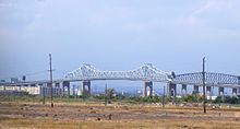
 Aerial view of the Goethals Bridge (top left) with the Arthur Kill Vertical Lift Bridge at bottom right | |
| Coordinates | 40°38′10″N 74°11′49″W / 40.636°N 74.197°WCoordinates: 40°38′10″N 74°11′49″W / 40.636°N 74.197°W |
| Carries | 6 lanes of |
| Crosses | Arthur Kill |
| Locale | Elizabeth, New Jersey and Howland Hook, Staten Island, New York, United States |
| Maintained by | Port Authority of New York and New Jersey |
| ID number | 3800072 |
| Characteristics | |
| Design | Cantilever bridge (Original) dual-span cable-stayed twin bridge (New span) |
| Total length | 7,109 ft (2,167 m)[1] |
| Width | 62 ft (19 m)[1] |
| Longest span | 672 ft (205 m)[1] |
| Clearance above | 14 ft (4.3 m) |
| Clearance below | 140 ft (43 m)[1] |
| History | |
| Opened | June 29, 1928 (original span) June 10, 2017 (new eastbound span) May 21, 2018 (new westbound span) |
| Closed | June 9, 2017 (original span) |
| Statistics | |
| Daily traffic | 82,852 (2016)[2] |
| Toll | (Eastbound only) As of January 5, 2020:
|
| Location | |
 | |

The Goethals Bridge /ˈɡɒθəlz/ is the name of a pair of cable-stayed bridge spans connecting Elizabeth, New Jersey, to Staten Island, New York, in the United States. The spans cross a strait known as Arthur Kill, and replace a cantilever bridge span built in 1928. The bridge is operated by the Port Authority of New York and New Jersey.
The original cantilever span was one of the first structures built by the Port Authority. The New Jersey side is about 2.5 miles (4 km) south of Newark Liberty International Airport. The bridge was grandfathered into Interstate 278, and named for Major General George Washington Goethals, who supervised construction of the Panama Canal and was the first consulting engineer of the Port Authority.
In 2013, two new cable-stayed crossings, running parallel to the old cantilever bridge and replacing it, were approved. The new eastbound span opened on June 10, 2017, at which time the original span was closed. The old cantilever span was dismantled in January 2018 and the new westbound span opened on May 21, 2018.
Original bridge[]

A steel truss cantilever design by John Alexander Low Waddell, who also designed the Outerbridge Crossing, the original Goethals was 672 ft (205 m) long central span, 7,109 feet (2,168 m) long in total, 62 feet (19 m) wide, had a clearance of 135 feet (41.1 m) and had four lanes for traffic.[3]
The Port Authority had $3 million of state money and raised $14 million in bonds to build the Goethals Bridge and the Outerbridge Crossing; the Goethals bridge construction began on September 1, 1925 and cost $7.2 million (equivalent to $84,971,000 in 2019). It and the Outerbridge Crossing opened on June 29, 1928.[4]
The original Goethals Bridge replaced three ferries and was the immediate neighbor of the Arthur Kill Rail Bridge. Its unusual[3] mid-span height was a requirement of the New Jersey ports. The bridge was named for Major General George Washington Goethals, who supervised construction of the Panama Canal and was the first consulting engineer of the Port Authority.[5]
Connecting onto the New Jersey Turnpike, it served as one of the main routes for traffic between New Jersey and Brooklyn via the Staten Island Expressway and the Verrazzano-Narrows Bridge. The original Goethals Bridge did not recoup its construction costs until the Verrazzano-Narrows Bridge was completed in 1964, facilitating regional through-traffic across Staten Island to Brooklyn. The same was true of the Outerbridge Crossing. The original Goethals Bridge had two 10-foot-wide (3.0 m) lanes in each direction, which did not meet the 12-foot (3.7 m) requirement of modern highway design standards. The bridge also had no shoulders for emergency access, or pedestrian walkways or bike paths. By 2002, the bridge carried 15.68 million vehicles per year.
An initial study in 1997 concluded that the optimal solution would be a parallel span. However, a more recent study suggested that the original span had only 10 years of life left, even with the recent deck rehabilitation, and that the optimal solution was an entirely new span. The choosing of the full replacement option was followed by the submittal of several design alternatives, alongside a "no build" option. The new bridge design, upon the completion of the westbound span, also include additional lanes of traffic, high-speed E-ZPass lanes, and a reconstruction and widening of Interstate 278 from exit 4 in New York (NY 440 South) to Route 439 in New Jersey. The span was demolished starting in January 2018, after the opening of the replacement bridges.[6]
New bridge[]


The initial alternatives put forth in mid-2006 included the option of twin three-lane replacement bridges north and south of the original alignment, which was completely eliminated; and twin three-lane replacement bridges (one south, and one along the original alignment), with the latter being built after the demolition of the original bridge, which was refined to be a single-span bridge instead of twin bridges. The twin-bridge alternative was dropped because of a height restriction set up by the FAA to prevent interferences with flights at Newark Liberty International Airport. The Goethals Bridge towers were not to exceed 272 feet in height and required to slant outwards because of aircraft flight patterns. This would also prevent ice from falling onto the roadway during winter months.[7] Public open houses were held in Staten Island and Elizabeth, and the Draft Environmental Impact Statement (DEIS) was issued. Formal public hearings on the DEIS were held in July 2009.[8]
All alternatives proposed that the bridge be single level, cable-stayed, double spans, separated by towers with a height of 135 feet (41 m) above the high-water mark of the Arthur Kill shipping channel. The 900 ft (270 m) main span[7] of each bridge holds three 12 ft (3.7 m) lanes with a 12 ft (3.7 m) outer shoulder and 5 ft (1.5 m) inner shoulder. The westbound span features a new 10 ft (3.0 m) walkway for pedestrians and cyclists. In addition, permanent access roads would be built under the bridge on land for maintenance, security, and construction purposes.[9] Lastly, space would be left in between the two bridges to accommodate potential mass-transit services.[10][11] For mass transit, studies indicated that a bus-only lane was not economically viable but that a high-occupancy vehicle lane open to buses as well as high-occupancy autos would be appropriate during rush hours if traffic supported it. Provision for rail transit was rejected; however, planners decided that whatever alternative was constructed, the design and structural integrity should ideally be able to be retrofitted for such at a later date. The suggestion for a freight rail connection was dismissed as uneconomic.[12]

Also as part of the construction, improvements to approaches and nearby interchanges were made. These include the New Jersey Turnpike exit 13 toll plaza, the Staten Island toll plaza, and the Interstate 278/NY 440 interchange. In addition, while separate from the bridge replacement project, the New Jersey Department of Transportation may construct full movements at the Interstate 278/U.S. Route 1/9 junction to coincide with the bridge's replacement.[13]
On April 24, 2013, the Port Authority approved the $1.5-billion Goethals Bridge Project[7] for preliminary funding, and broke ground in May 2014.[14] The old bridge was closed on June 9, 2017, with eastbound traffic using the new eastbound bridge starting on June 10[15] and westbound traffic opening the next day.[16] Initially, the new eastbound span carried 2 lanes of traffic in each direction, with each lane 11 feet wide until the new westbound span is complete. Once completed, the new westbound span would restore pedestrian and bicycle access.[17][11] Westbound traffic was shifted from the new eastbound span to the newly opened westbound span on May 21, 2018.[18][19] The bikeway and pedestrian walkway was set to open by mid-2018[20] but was then pushed back to an undetermined date.[21] The bike path and pedestrian walkway finally opened on March 4, 2020.[22]
The Goethals Bridge Replacement Project was given several prestigious awards upon its completion. In the highway/bridge category, the project won an ENR New York Best Projects and the Excellence in safety award, and it received the ENR New York's Project of the Year for 2018.[7]
Tolls[]
As of January 5, 2020, the tolls-by-mail rate going from New Jersey to New York are $16 for cars and motorcycles; there is no toll for passenger vehicles going from New York to New Jersey. New Jersey and New York-issued E-ZPass users are charged $11.75 for cars and $10.75 for motorcycles during off-peak hours, and $13.75 for cars and $12.75 for motorcycles during peak hours. Users with E-ZPass issued from agencies outside of New Jersey and New York are charged the cash rate.[23]
Tolls are only collected for eastbound traffic. Originally, tolls were collected in both directions. In August 1970, the toll was abolished for westbound drivers, and at the same time, eastbound drivers saw their tolls doubled. The tolls of eleven other New York–New Jersey and Hudson River crossings along a 130-mile (210 km) stretch, from the Outerbridge Crossing in the south to the Rip Van Winkle Bridge in the north, were also changed to south- or eastbound-only at that time.[24]
Open-road cashless tolling began on September 4, 2019. The tollbooths were dismantled, and drivers are no longer able to pay cash at the bridge. Instead, there are cameras mounted onto new overhead gantries located on the Staten Island side. A vehicle without E-ZPass has a picture taken of its license plate and a bill for the toll is mailed to its owner. For E-ZPass users, sensors detect their transponders wirelessly.[25][26]
See also[]
 Transport portal
 Engineering portal
 New Jersey portal
 New York (state) portal
 New York City portal
- List of bridges documented by the Historic American Engineering Record in New Jersey
- List of bridges documented by the Historic American Engineering Record in New York (state)
References[]
- ^ Jump up to: a b c d "Facts & Info - Goethals Bridge". Port Authority of New York & New Jersey. Retrieved February 27, 2010.
- ^ "New York City Bridge Traffic Volumes" (PDF). New York City Department of Transportation. 2016. p. 11. Retrieved March 16, 2018.
- ^ Jump up to: a b Jackson, Kenneth T., ed. (1995). The Encyclopedia of New York City. New Haven: Yale University Press. p. 471. ISBN 0300055366.
- ^ "Two Bridges Open Over Arthur Kill. Traffic Between Staten Island and New Jersey Begins at 5 A.M. Without Ceremony. New Bus Service Starts. Borough President Lynch Will Ask Legal Action to Bar It as Bad for Business". The New York Times. June 30, 1928. p. 35. Retrieved February 27, 2010.
- ^ "Happy Bridge Birthday". Staten Island Advance. June 27, 2008. Retrieved September 16, 2010.
The Goethals Bridge, which links Elizabeth, N.J., with Mariners Harbor across the Arthur Kill, was named in memory of Major General George Washington Goethals. Goethals was the builder of the Panama Canal, and served as the first consulting engineer of the Port Authority.
- ^ "Time-lapse video shows dismantling of local bridge". WABC-TV. January 20, 2018. Retrieved June 13, 2018.
- ^ Jump up to: a b c d Stabile, Tom. "Goethals Bridge: ENR New York's Project of the Year". www.enr.com. Engineering News-Record. Retrieved September 28, 2020.
- ^ "Draft EIS Published". Archived from the original on December 7, 2012. Retrieved December 4, 2012.
- ^ "Refinement of Alternatives for EIS Analysis" (PDF). Retrieved December 4, 2012.
- ^ "Goethals Bridge Replacement". Retrieved December 4, 2012.
- ^ Jump up to: a b Lore, Diane C. (June 10, 2017). "5 facts you need to know about the new Goethals Bridge". Staten Island Advance. Retrieved October 5, 2017.
- ^ "New York State Assembly | Bill Search and Legislative Information". assembly.state.ny.us. Retrieved April 11, 2020.
- ^ "Goethals Bridge Interchange Ramps – "Missing Links"". The Port Authority of New York and New Jersey: Bridges and Tunnels. The Port Authority of New York and New Jersey. Retrieved April 27, 2017.
- ^ "An interactive map of planned developments in the next decade". Retrieved June 12, 2018.
- ^ Fugallo, Nick (June 11, 2017). "First span of new Goethals Bridge opens". New York Post. Retrieved June 12, 2017.
- ^ Porpora, Tracey (June 11, 2017). "Goethals Bridge now open in both directions". SILive.com. Retrieved June 12, 2017.
- ^ "Bridges and Tunnels". Retrieved December 4, 2012.
- ^ Grunlund, Maura (May 21, 2018). "First a.m. rush hour for new Goethals Bridge to New Jersey". SILive.com. Retrieved May 21, 2018.
- ^ "New Goethals Bridge Westbound Span Now Open". CBS New York. May 21, 2018. Retrieved May 21, 2018.
- ^ Bascome, Erik (May 21, 2018). "Goethals Bridge walkway/bikeway to open by end of summer". SILive.com. Retrieved May 21, 2018.
- ^ Strunsky, Steve (November 10, 2018). "or bike - to Staten Island". nj.com. Retrieved May 30, 2019.
- ^ Bascome, Erik (March 4, 2020). "First Staten Islander bikes across Goethals Bridge as shared-use path opens". silive. Retrieved March 5, 2020.
- ^ "Tolls". Port Authority of New York & New Jersey. Retrieved February 2, 2020.
- ^ Moran, Nancy (August 13, 1970). "One‐Way Tolls Confusing Some Drivers". The New York Times. Retrieved April 9, 2018.
- ^ Bascome, Erik (June 28, 2018). "Goethals, Outerbridge to get cashless tolling in 2019". silive.com. Retrieved March 21, 2019.
- ^ Bascome, Erik (March 15, 2019). "Cashless tolling for Outerbridge Crossing expected by end of April". silive.com. Retrieved March 21, 2019.
External links[]
| Wikimedia Commons has media related to Goethals Bridge. |
- Goethals Bridge
- Goethals Bridge Replacement
- Historic American Engineering Record (HAER) No. NY-305, "Goethals Bridge"
- Goethals Bridge at Structurae
| hide Bridges of the Arthur Kill | ||||
|---|---|---|---|---|
| ||||
- 1928 establishments in New York (state)
- 1928 establishments in New Jersey
- 2017 establishments in New York (state)
- 2017 establishments in New Jersey
- Buildings and structures in Elizabeth, New Jersey
- Bridges in Staten Island
- Bridges in Union County, New Jersey
- Bridges completed in 1928
- Bridges completed in 2017
- Bridges on the Interstate Highway System
- Cantilever bridges in the United States
- Cable-stayed bridges in the United States
- Historic American Engineering Record in New Jersey
- Historic American Engineering Record in New York City
- Interstate 78
- Interstate vehicle bridges in the United States
- Port Authority of New York and New Jersey
- Road bridges in New York City
- Road bridges in New Jersey
- Steel bridges in the United States
- Toll bridges in New York City
- Toll bridges in New Jersey
- Tolled sections of Interstate Highways
- Transportation in Elizabeth, New Jersey
- Transportation projects in New York City
- Truss bridges in the United States