Queensboro Bridge
Ed Koch Queensboro Bridge | |
|---|---|
 (2010) | |
| Coordinates | 40°45′25″N 73°57′18″W / 40.757°N 73.955°WCoordinates: 40°45′25″N 73°57′18″W / 40.757°N 73.955°W |
| Carries | 9 lanes (4 upper, 5 lower) of |
| Crosses | East River |
| Locale | New York City (Manhattan–Queens) |
| Other name(s) | Queensboro Bridge, 59th Street Bridge |
| Maintained by | New York City Department of Transportation |
| ID number | 2240048 |
| Characteristics | |
| Design | Double-decked Cantilever bridge |
| Total length | 3,724 ft 6 in (1,135.2 m) |
| Width | 100 ft (30 m) |
| Height | 350 ft (110 m) |
| Longest span | 1,182 ft (360 m) (west span) 984 ft (300 m) (east span) 630 ft (192 m) (center span) |
| Clearance above | 12 ft (3.7 m) (upper level) |
| Clearance below | 130 ft (40 m) |
| History | |
| Architect | Henry Hornbostel |
| Designer | Gustav Lindenthal |
| Engineering design by | Leffert L. Buck |
| Opened | March 30, 1909 |
| Statistics | |
| Daily traffic | 170,277 (2016)[1] |
| Toll | Free |
Queensboro Bridge | |
| Location | 59th Street Manhattan, New York City |
| Built | 1909 |
| Architect | Gustav Lindenthal (designer) Henry Hornbostel (architect) |
| Architectural style | Beaux-Arts; through cantilever truss |
| NRHP reference No. | 78001879[2] |
| Significant dates | |
| Added to NRHP | December 20, 1978 |
| Designated NYCL | April 16, 1974 |
| Location | |
 | |

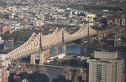
The Queensboro Bridge, officially named the Ed Koch Queensboro Bridge, is a cantilever bridge over the East River in New York City. Completed in 1909, it connects the neighborhood of Long Island City in the borough of Queens with the Upper East Side in Manhattan, passing over Roosevelt Island. The bridge is also known as the 59th Street Bridge because its Manhattan end is located between 59th and 60th streets.
The Queensboro Bridge carries New York State Route 25 (NY 25), which terminates at the bridge's western end in Manhattan, and also once carried NY 24 and NY 25A. The western leg of the Queensboro Bridge is flanked on its northern side by the freestanding Roosevelt Island Tramway. The bridge was, for a long time, simply called the Queensboro Bridge, but in March 2011, the bridge was officially renamed in honor of former New York City mayor Ed Koch.
The Queensboro Bridge is the northernmost of four toll-free vehicular bridges connecting Manhattan Island to Long Island, along with the Williamsburg, Manhattan, and Brooklyn bridges to the south. It is the first entry point into Manhattan in the course of the New York City Marathon and the last exit point out of Manhattan in the Five Boro Bike Tour.
Description[]


The Queensboro Bridge is a two-level double cantilever bridge, with separate cantilevered spans over channels on each side of Roosevelt Island joined by a fixed central truss.[3] In all it has five spans, including approaches between the cantilevered sections and each terminus. Their lengths are as follows:[4]
- Manhattan to Roosevelt Island span length (cantilever): 1,182 ft (360 m)
- Roosevelt Island span length: 630 ft (190 m)
- Roosevelt Island to Queens span length (cantilever): 984 ft (300 m)
- Manhattan approach span 469.5 ft (143.1 m)
- Queens approach span 459 ft (140 m)
- Total length between anchorages: 3,724 ft (1,135 m)
- Total length including approaches: 7,449 ft (2,270 m)
Until it was surpassed by the Quebec Bridge in 1917, the span between Manhattan and Roosevelt Island was the longest cantilever in North America.[5]
Levels[]
The upper level of the bridge has four lanes of automobile traffic, consisting of two roadways with two lanes in each directions. It provides a view of the bridge's cantilever truss structure and the New York skyline. Although the two upper level roadways both end at Thomson Avenue on the Queens side, they diverge in opposite directions on the Manhattan side. The lanes used by westbound traffic, located on the northern side of the bridge, lead north to 62nd and 63rd Streets. On the other hand, the lanes normally used by eastbound traffic are located on the southern side of the bridge lead south to 57th and 58th Streets. The roadway to 57th and 58th Streets is used as a westbound high-occupancy vehicle lane during rush hours.[6]
The lower level has five vehicular lanes, the inner four for automobile traffic and the southern outer lane for automobile traffic as well, used exclusively for Queens-bound traffic. The North Outer Roadway was converted into a permanent pedestrian walk and bicycle path in September 2000.[7]
Manhattan approach[]
The Manhattan approach to the bridge is supported on a series of Guastavino tile vaults which formed the elegant ceiling of the former Food Emporium Bridge Market and the restaurant Guastavino's, located under the bridge. Originally, this open air promenade was known as Bridgemarket and was part of Hornbostel's attempt to make the bridge more hospitable in the city.[8] In February 2020, it was announced that Trader Joe's is planning to open a supermarket in this space.[9]
History[]
Construction[]
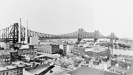
Serious proposals for a bridge linking Manhattan to Long Island City were first made as early as 1838, and attempts to finance such a bridge were made by a private company beginning in 1867. Its efforts never came to fruition and the company went bankrupt in the 1890s.[10] Successful plans finally came about in 1903 – after the creation in 1898 of Greater New York City through the amalgamation of Manhattan (New York City), Brooklyn, Queens, the Bronx and Staten Island[11] – under the new city's Department of Bridges, led by Gustav Lindenthal, who was appointed to the new position of Commissioner of Bridges in 1902, in collaboration with Leffert L. Buck and Henry Hornbostel, designers of the Williamsburg Bridge.
Construction soon began, but it would take until 1909 for the bridge to be completed due to delays from the collapse of an incomplete span during a windstorm, and from labor unrest, which included an attempt to dynamite one span. The bridge opened for public use on March 30, 1909,[12] having cost about $18 million and 50 lives. There was a ten-cent toll to drive over the bridge.[13] The bridge's ceremonial grand opening was held on June 12, 1909.[14] At the time, it was the fourth longest bridge in the world.[12] The grand opening included a fireworks display.[14] The bridge was then known as the Blackwell's Island Bridge, from an earlier name for Roosevelt Island.[15]
Early days[]
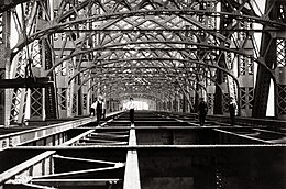

The bridge's upper level originally contained two pedestrian walkways and two elevated railway tracks (which connected a spur of the IRT Second Avenue Elevated Line in Manhattan to the Queensboro Plaza station in Queens).[12] Three lanes of roadway were installed on the south side of the upper level in 1931, replacing the former upper-level walkway.[16] All service on the Second Avenue Elevated was discontinued in 1942.[17] From 1955 to 1958, two additional lanes were built on the upper level. The upper-level ramps on the Queens end of the bridge were built during the same time.[18]
The lower deck originally hosted four motor traffic lanes, and what is now the "outer roadway" and pedestrian walk were two trolley lanes.[12] A trolley connected passengers from Queens and Manhattan to a stop in the middle of the bridge, where passengers could take an elevator or the stairs down to Roosevelt Island.[19] The trolley operated from the bridge's opening until April 7, 1957.[20] The trolley lanes and mid-bridge station, as well as the stairs, were removed in the 1950s following the trolley's discontinuation,[21] and for the next few decades the bridge carried 11 lanes of automobile traffic.
In 1919, an elevator building called the elevator storehouse was built adjacent to the bridge on the north side located about where the current tram station is to transport cars and passengers to what was then called Welfare Island, now Roosevelt Island. It was known as the "upside-down" building because its main entrance was on the 10th floor, the height of the bridge deck. This provided access to the hospitals on the island. This building has now been demolished.[21][22] Then, in 1955, the Welfare Island Bridge from Queens opened, allowing automobile and truck access to the island and the only non-aquatic means in and out of the island; the vehicular elevator to Queensboro Bridge then closed,[22] but wasn't demolished until 1970.[citation needed] However, as late as August 1973, a separate passenger elevator ran during the work week from near the Queens end of the bridge to Welfare Island via the Welfare Island Elevator Storehouse, which was described at the time as "clean but gloomy".[23][24]
Since the 1980s[]
After years of decay and corrosion, an extensive renovation of the bridge began in 1987 and completed in 2012, having cost over $300 million.
For a brief period in 1997, the traffic directions of the upper-level roadways were reversed during rush hours so that the upper level used a left-hand traffic pattern. Manhattan-bound traffic used the southern roadway while Queens-bound traffic used the northern roadway.[25] After residents of the Upper East Side voiced concerns about severe rush-hour congestion, this traffic pattern was discontinued, and the south-side walkway on the lower level was converted to a Queens-bound vehicular lane during the evening rush hour.[26] The outer roadway was later opened to vehicles at all times, but after a series of fatal crashes in 2013, officials decided to close the ramp during the nighttime.[27]
In March 2009, the New York City Bridge Centennial Commission sponsored events marking the centennial of the bridge's opening.[28] The bridge was also designated as a National Historic Civil Engineering Landmark by the American Society of Civil Engineers during the year of its centennial anniversary.[5]
In December 2010, the city announced that the bridge would be renamed in honor of former Mayor Ed Koch from the Queensboro Bridge to the Ed Koch Queensboro Bridge.[29] The new name became official in March 2011. The renaming decision was unpopular among Queens residents and business leaders, and many local residents continue to refer to the bridge by its older name.[30][31][32] New York City Council member Peter Vallone Jr. from Queens vowed to remove Koch's name from the bridge. Vallone said, "Never in a million years would they think to rename the Brooklyn or Manhattan bridges, but for some reason, it was OK to slap Queens around."[31]
In January 2021, the city decided to install a two-way protected bike path on the northern outer roadway of the lower level, to be completed by 2022. The southern outer roadway, which at the time was used by vehicular traffic, would be used exclusively by pedestrians.[33][34]
Public transportation[]

Rail tracks[]
In addition to the two elevated railway tracks, the bridge also had four streetcar tracks. The following Queens lines operated over the bridge:
- Queensboro Bridge Local, 1909–1957 (last streetcar line in the city)
- Astoria Line (Queens surface), 1910–1939
- Steinway Line, 1910–1939
- College Point Line, 1910–1925
- Corona Line (surface), 1910–1922
- Queens Boulevard Line (surface), 1913–1937
One Manhattan line operated over the bridge, the Third Avenue Railway's 42nd Street Crosstown Line from 1910 to 1950.
Buses[]
The bridge carries the Q32 local bus route operated by MTA New York City Transit and the Q60 and Q101 local bus routes operated by the MTA Bus Company. The bridge also carries 20 express bus routes in the eastbound direction only: the MTA Bus Company's QM1, QM2, QM3, QM4, QM5, QM6, QM10, QM15, QM16, QM17, QM18, QM20, QM21, QM24, QM31, QM32, QM34, QM35, QM36, QM40, QM42 and QM44, and New York City Transit's X63, X64, and X68. (These bus routes use the Queens-Midtown Tunnel for westbound travel.)[35]
In popular culture[]


Literature
- In F. Scott Fitzgerald's novel The Great Gatsby, Jay Gatsby and Nick Carraway traverse the bridge on their way from Long Island to Manhattan. "The city seen from the Queensboro Bridge," Nick says, "is always the city seen for the first time, in its first wild promise of all the mystery and the beauty in the world".[15]
- In E.B. White's novel Charlotte's Web, Charlotte tells Wilbur that the bridge took eight years to build, while she could have built a web in a night.
- In the climax of Truman Capote's novel Summer Crossing, the main character commits suicide and murders three passengers by crashing her car into the Queensboro Bridge.
- In the climax of Norm Macdonald's memoir Based on a True Story, Adam Eget is found, making a living underneath the Queensboro Bridge, jerking off punks for fifteen dollars a man.
Music
- The title of the Simon & Garfunkel song "The 59th Street Bridge Song (Feelin' Groovy)" refers to the Queensboro Bridge.[15] Harpers Bizarre covered the song in 1967, with the record rising to No. 13 on the US Billboard Hot 100 chart, making it the musical group's best-selling hit.
- The Australian group, The Seekers, covered the Simon classic on their 1967 album, Seekers Seen in Green.
- It is also cited in the Jack's Mannequin song "Diane, the Skyscraper," on the Dear Jack EP.
- It is also mentioned by rapper and Queensbridge native MC Shan in his song "The Bridge".
- It is the title of a track from the album Indiana by singer-songwriter David Mead.
Music videos
- Billy Joel's video for his 1985 single "You're Only Human (Second Wind)" was primarily filmed on the bridge.
- Pink Floyd's original video for "Us and Them" prominently features footage of the bridge.
- The Queensbridge, Queens Hip Hop group Mobb Deep filmed the music video for "Shook Ones (Part II)" on the bridge.
Film
- In the 1932 Paramount Pictures light comedy film No Man of Her Own, starring Clark Gable and Carole Lombard, Lombard's character looks out of her hotel window to a view across the East River and the Queensboro Bridge, and refers to "Blackwell's Island", now known as Roosevelt Island.
- In the 1936 screwball comedy My Man Godfrey, the bridge is seen several times as the location of the city dump where the "forgotten men" live.
- In the 1948 film Sorry, Wrong Number, Leona Stevenson (Barbara Stanwyck) is an invalid. Through her open bedroom window we see the bridge with frequent trains crossing, and on the telephone she overhears a murder plot in which the killer tells someone that he will wait till the train is crossing the bridge "in case her window is open and she should scream."
- In the 1958 Warner Brothers' film Auntie Mame, the bridge serves as a backdrop for Mame Dennis' Beekman Place apartment.
- The bridge appears prominently in several scenes of the 1966 comedy film Any Wednesday, which starred Jane Fonda, Jason Robards, and Dean Jones.
- In Woody Allen's 1979 film Manhattan, the characters played by Allen and Diane Keaton relax on a bench in front of the bridge at dawn. The shot became the film's poster image.
- The final chase in the 1981 film Escape From New York takes place on the bridge. It is previously named by the President's kidnappers in a ransom note left in his briefcase in Central Park as where they'll release the President if their terms are met.
- The climax of the 1985 film Turk 182! takes place on and around the Queensboro Bridge.
- The bridge is seen in the opening credits scene of the 1985 film Death Wish 3.
- In the 1991 film New Jack City, Nino Brown and the Duh Duh Man hang a man over the side of the bridge because of a drug debt he owes. Eventually they throw him off it to his death.
- In the 1992 family comedy film Home Alone 2: Lost in New York, the protagonist Kevin is seen taking a taxi over the bridge upon his entrance into New York City.
- In the 1993 romantic comedy film For Love or Money, the main protagonists Doug Ireland (Michael J. Fox) and Andy Hart (Gabrielle Anwar) reunite on opposite sides of the Queensboro Bridge and call out to each other on what they found out about unscrupulous billionaire Christian Hanover (Anthony Higgins).
- In the 1997 American action thriller film Conspiracy Theory, directed by Richard Donner, the bridge is crossed many times throughout the film.
- In the 2002 superhero film Spider-Man, the climax of the film where Spider-Man battles against his archenemy, the Green Goblin takes place around the bridge.
- In the 2003 slapstick comedy film Anger Management, Dave Buznik (Adam Sandler) and Dr. Buddy Rydell (played by Jack Nicholson), stop their car in the middle of the bridge to sing "I Feel Pretty".
- In the 2003 American comedy film Elf, when Buddy is ostracized by his father, he goes to the Queensboro Bridge to brood. It is from there that he sees Santa's sleigh out of control, on its way to Central Park.
- The 2010 movie Salt has a scene that takes place on, and was filmed on, the Queensboro Bridge.
- The Queensboro Bridge was featured in 2012 as one of the few remaining bridges in The Dark Knight Rises after Bane has taken control of the city.
- In the 2013 movie Now You See Me, a car chase across the bridge leads to a crash in which the death of a character is faked.
- The bridge was featured in the 2014 film A Most Violent Year, in which there is an attempted hijacking of a fuel truck on it, followed by a short shootout and foot chase that leads down one of the bridge's service staircases. The bridge is referred to as the "59th Street Bridge" in the film.
- In the 2018 film Avengers: Infinity War, Peter Parker is on a school bus driving over the Queensboro Bridge. When he sees an alien spaceship over Manhattan, he changes into Spider-Man and exits the bus, swinging towards the spaceship.
Television
- The Queensboro Bridge has been shown in the credits of the television series Archie Bunker's Place, The King of Queens, Rescue Me and Alphas. In addition, the opening sequence of Taxi depicts a Checker Taxi cab driving out of Manhattan on the upper deck of the bridge, and George and Louise Jefferson are shown riding in a taxi on the bridge's lower deck in the opening sequence of The Jeffersons.
- It is referred to in the opening theme of The King of Queens, in the line "...sitting here in traffic, on the Queensboro Bridge tonight."
- The bridge is also referred to in The Simpsons episode "You Only Move Twice", when Hank Scorpio destroys it to show that he's not bluffing (though there is a possibility that the bridge collapsed on its own).
- An illustration of the bridge by Aurore Giscard d'Estaing is used in the main title of the A&E TV series A Nero Wolfe Mystery.
- The bridge is referenced often on the Internet television program and podcast Norm Macdonald Live, when host Norm Macdonald tells his guest about how he discovered his cohost Adam Eget; the story goes that Eget would "jerk off punks for 15 bucks a man" under the bridge.
Video games
- The bridge was destroyed in the video game Crysis 2 when a facility on Roosevelt Island exploded, causing the bridge to violently collapse.
- The bridge appears in the game Driver: Parallel Lines and is able to be traveled on foot or by car. During the mission "Kidnap" the player must blow up a billboard on the Manhattan side to block traffic.
- The bridge is part of the Nintendo DS game C.O.P.: The Recruit.
- The bridge appears in The Crew and The Crew 2.
See also[]
References[]
Notes
- ^ "New York City Bridge Traffic Volumes" (PDF). New York City Department of Transportation. 2016. p. 9. Retrieved March 16, 2018.
- ^ "National Register Information System – (#78001879)". National Register of Historic Places. National Park Service. July 9, 2010.
- ^ "Project Page:2000 Biennial Bridge Inspection of the Queensboro Bridge over the East River". HAKS Corporation. Archived from the original on June 25, 2008. Retrieved June 15, 2008.
- ^ Queensborough (59th Street) Bridge, nycroads.com
- ^ Jump up to: a b "Queensboro Bridge". ASCE Metropolitan Section. Retrieved November 12, 2016.
- ^ "HOV Lanes". www.nyc.gov. Retrieved December 18, 2017.
- ^ "Queensboro Bridge Rehabilitation Program". New York City Department of Transportation. Archived from the original on March 30, 2008. Retrieved March 13, 2010.
- ^ Dunlap, David W. (March 7, 1999). "Bridgemarket Emerging, After 22 Years". The New York Times. Retrieved February 20, 2010.
- ^ Cuozzo, Steve (February 17, 2020). "Trader Joe's to fill in old Food Emporium store under Queensboro Bridge". New York Post. Retrieved August 16, 2020.
- ^ Queensboro Bridge (Historic Overview)
- ^ Eldredge & Horenstein (2014), p.125
- ^ Jump up to: a b c d Staff (March 31, 1909). "Queensboro Bridge Opens to Traffic" (PDF). The New York Times. p. 2. Retrieved February 20, 2010.
- ^ Staff (April 4, 1909) "White Maps New Bridge; Issues Bulletin of Instructions for Reaching Structure" The New York Times p.S4
- ^ Jump up to: a b Staff (June 13, 1909). "300,000 See Queens Linked to Old City" (PDF). The New York Times. p. 1. Retrieved February 20, 2010.
- ^ Jump up to: a b c Barron, James (March 29, 2009). "To Fans, Queensboro Bridge Is a Steel Swan, Not an 'Ugly Duckling'". The New York Times. p. A22. Retrieved March 29, 2009.
- ^ "Mayor Opens Deck on Queens Bridge; the Mayor Opens Another Bridge Remodeled for Traffic Needs" (PDF). The New York Times. June 26, 1931. ISSN 0362-4331. Retrieved December 18, 2017.
- ^ "Manhattan East Side Transit Alternatives (MESA): Major Investment Study/Draft Environmental Impact Statement, August 1999". Metropolitan Transportation Authority, United States Department of Transportation, Federal Transit Administration. August 1999. Retrieved July 11, 2016.
- ^ Feron, James (1958). "QUEENS SPAN JOB NEAR COMPLETION; 2 Lanes and New Ramps on Queensboro Bridge Due to Be Finished in May" (PDF). The New York Times. ISSN 0362-4331. Retrieved December 18, 2017.
- ^ "Roosevelt Island Tramway". New York Correction History Society. Retrieved February 20, 2010.
- ^ Phillips, McCandlish (April 7, 1957). "City's Last Trolley at End of Line; Buses Will Replace 49-Year Route on Queensboro Span" (PDF). The New York Times. p. 1. Retrieved August 17, 2008.
- ^ Jump up to: a b Eldredge & Horenstein (2014), p.126
- ^ Jump up to: a b McCandlish, Phillips (April 7, 1957). "City's Last Trolley at End of Line; Buses Will Replace 49-Year Route on Queensboro Span" (PDF). The New York Times. p. 1. Retrieved August 17, 2008.
- ^ Welch, Mary Scott (July 2, 1973). "Walking the City's Bridges". New York. p. 31. Retrieved March 7, 2015.
- ^ Petroff, John (August 27, 1973). "Bridge Bits" (letter to the editor)". New York. p. 5. Retrieved March 7, 2015.
- ^ Pierre-Pierre, Garry (October 31, 1996). "Queensboro Bridge Entrances Will Exit". The New York Times. ISSN 0362-4331. Retrieved December 18, 2017.
- ^ Kennedy, Randy (November 11, 1996). "Queensboro To Restore Old Routes As of Today". The New York Times. ISSN 0362-4331. Retrieved December 18, 2017.
- ^ Nir, Sarah Maslin (December 24, 2013). "Queensboro Bridge Lane to Be Closed Every Night". The New York Times. ISSN 0362-4331. Retrieved December 18, 2017.
- ^ "Queensboro Bridge Centennial Celebration Events and Exhibits". NYC Bridge Centennial Commission. Archived from the original on June 8, 2012. Retrieved February 20, 2010.
- ^ Bultman, Matthew & Fanelli, James (December 9, 2010). "Just call 59th Street Bridge the Ed Koch". New York Daily News. Retrieved December 9, 2010.
- ^ Lisberg, Adam (February 28, 2011). "Queensboro Bridge should not be renamed after former Mayor Ed Koch, 70% of Queens biz leaders say". New York Daily News. Archived from the original on June 12, 2012. Retrieved February 28, 2011.
- ^ Jump up to: a b Hernandez, Javier C. (March 23, 2011). "Council Votes to Rename Queensboro Bridge for Koch". The New York Times. Retrieved March 23, 2011.
- ^ Einhorn, Erin (March 23, 2011). "Queensborough renamed in honor of Koch". New York Daily News. Retrieved March 27, 2018.
- ^ Robbins, Christopher (January 28, 2021). "The Brooklyn Bridge Will Finally Get Its Own Bike Lane". Gothamist. Retrieved January 28, 2021.
- ^ Fitzsimmons, Emma G. (January 28, 2021). "Car Lanes to Become Bike Lanes on 2 Major New York City Bridges". The New York Times. ISSN 0362-4331. Retrieved January 28, 2021.
- ^ "Queens Bus Map" (PDF). Metropolitan Transportation Authority. September 2019. Retrieved December 1, 2020.
Bibliography
- "Abandoned Stations: Queensborough Bridge Railway Terminal"
- Eldredge, Niles and Horenstein, Sidney (2014). Concrete Jungle: New York City and Our Last Best Hope for a Sustainable Future. Berkeley, California: University of California Press. ISBN 978-0-520-27015-2.
- Greater Astoria Historical Society and Roosevelt Island Historical Society (2008). The Queensboro Bridge. USA: Arcadia Publishing. ISBN 978-0-7385-5488-4.
External links[]
| Wikimedia Commons has media related to Queensboro Bridge. |
- NYC DOT.gov
- NYCroads.com
- "Queensboro Bridge" on Transportation Alternatives
- Dave's Electric Railroads Thirty-three historic photographs of the Queensborough Bridge Railway trolley cars
- Historic American Engineering Record (HAER) No. NY-19, "Queensboro Bridge"
- Queensboro Bridge at Structurae
| hide Crossings of the East River | ||||
|---|---|---|---|---|
| ||||
| show Authority control |
|---|
- 1908 establishments in New York (state)
- Bike paths in New York City
- Bridges completed in 1909
- Bridges in Manhattan
- Bridges in Queens, New York
- Bridges on the National Register of Historic Places in New York City
- Bridges over the East River
- Buildings and structures on the National Register of Historic Places in Manhattan
- Cantilever bridges in the United States
- Double-decker bridges
- Henry Hornbostel buildings
- Historic American Engineering Record in New York City
- Historic Civil Engineering Landmarks
- Long Island City
- National Register of Historic Places in Queens, New York
- New York City Designated Landmarks in Manhattan
- New York City Designated Landmarks in Queens, New York
- Pedestrian bridges in New York City
- Railroad bridges in New York City
- Railroad bridges on the National Register of Historic Places in New York City
- Road bridges in New York City
- Road bridges on the National Register of Historic Places in New York City
- Roads with a reversible lane
- Roosevelt Island
- Steel bridges in the United States