Coney Island–Stillwell Avenue station
Coney Island–Stillwell Avenue | |||||||||||||||||||||||||||||||||||||||||||||||||||||||||||||||||||||||||||||||||||||||||||||||||||||||||||||||||||||||||||||||||||||||||||||||||||||||||||||||||||||||||||||||||||||||||||||||||||||||||||||||||
|---|---|---|---|---|---|---|---|---|---|---|---|---|---|---|---|---|---|---|---|---|---|---|---|---|---|---|---|---|---|---|---|---|---|---|---|---|---|---|---|---|---|---|---|---|---|---|---|---|---|---|---|---|---|---|---|---|---|---|---|---|---|---|---|---|---|---|---|---|---|---|---|---|---|---|---|---|---|---|---|---|---|---|---|---|---|---|---|---|---|---|---|---|---|---|---|---|---|---|---|---|---|---|---|---|---|---|---|---|---|---|---|---|---|---|---|---|---|---|---|---|---|---|---|---|---|---|---|---|---|---|---|---|---|---|---|---|---|---|---|---|---|---|---|---|---|---|---|---|---|---|---|---|---|---|---|---|---|---|---|---|---|---|---|---|---|---|---|---|---|---|---|---|---|---|---|---|---|---|---|---|---|---|---|---|---|---|---|---|---|---|---|---|---|---|---|---|---|---|---|---|---|---|---|---|---|---|---|---|---|
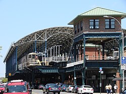
 Station building as seen from Surf Avenue | |||||||||||||||||||||||||||||||||||||||||||||||||||||||||||||||||||||||||||||||||||||||||||||||||||||||||||||||||||||||||||||||||||||||||||||||||||||||||||||||||||||||||||||||||||||||||||||||||||||||||||||||||
| Station statistics | |||||||||||||||||||||||||||||||||||||||||||||||||||||||||||||||||||||||||||||||||||||||||||||||||||||||||||||||||||||||||||||||||||||||||||||||||||||||||||||||||||||||||||||||||||||||||||||||||||||||||||||||||
| Address | 1243 Surf Avenue (near Stillwell Avenue) Brooklyn, NY 11224 | ||||||||||||||||||||||||||||||||||||||||||||||||||||||||||||||||||||||||||||||||||||||||||||||||||||||||||||||||||||||||||||||||||||||||||||||||||||||||||||||||||||||||||||||||||||||||||||||||||||||||||||||||
| Borough | Brooklyn | ||||||||||||||||||||||||||||||||||||||||||||||||||||||||||||||||||||||||||||||||||||||||||||||||||||||||||||||||||||||||||||||||||||||||||||||||||||||||||||||||||||||||||||||||||||||||||||||||||||||||||||||||
| Locale | Coney Island | ||||||||||||||||||||||||||||||||||||||||||||||||||||||||||||||||||||||||||||||||||||||||||||||||||||||||||||||||||||||||||||||||||||||||||||||||||||||||||||||||||||||||||||||||||||||||||||||||||||||||||||||||
| Coordinates | 40°34′38″N 73°58′52″W / 40.57722°N 73.98111°WCoordinates: 40°34′38″N 73°58′52″W / 40.57722°N 73.98111°W | ||||||||||||||||||||||||||||||||||||||||||||||||||||||||||||||||||||||||||||||||||||||||||||||||||||||||||||||||||||||||||||||||||||||||||||||||||||||||||||||||||||||||||||||||||||||||||||||||||||||||||||||||
| Division | B (BMT/IND)[1] | ||||||||||||||||||||||||||||||||||||||||||||||||||||||||||||||||||||||||||||||||||||||||||||||||||||||||||||||||||||||||||||||||||||||||||||||||||||||||||||||||||||||||||||||||||||||||||||||||||||||||||||||||
| Line | BMT Brighton Line IND Culver Line BMT Sea Beach Line BMT West End Line BMT Culver Line (formerly) | ||||||||||||||||||||||||||||||||||||||||||||||||||||||||||||||||||||||||||||||||||||||||||||||||||||||||||||||||||||||||||||||||||||||||||||||||||||||||||||||||||||||||||||||||||||||||||||||||||||||||||||||||
| Services | D F N Q | ||||||||||||||||||||||||||||||||||||||||||||||||||||||||||||||||||||||||||||||||||||||||||||||||||||||||||||||||||||||||||||||||||||||||||||||||||||||||||||||||||||||||||||||||||||||||||||||||||||||||||||||||
| Transit | |||||||||||||||||||||||||||||||||||||||||||||||||||||||||||||||||||||||||||||||||||||||||||||||||||||||||||||||||||||||||||||||||||||||||||||||||||||||||||||||||||||||||||||||||||||||||||||||||||||||||||||||||
| Structure | Elevated | ||||||||||||||||||||||||||||||||||||||||||||||||||||||||||||||||||||||||||||||||||||||||||||||||||||||||||||||||||||||||||||||||||||||||||||||||||||||||||||||||||||||||||||||||||||||||||||||||||||||||||||||||
| Platforms | 4 island platforms | ||||||||||||||||||||||||||||||||||||||||||||||||||||||||||||||||||||||||||||||||||||||||||||||||||||||||||||||||||||||||||||||||||||||||||||||||||||||||||||||||||||||||||||||||||||||||||||||||||||||||||||||||
| Tracks | 8 | ||||||||||||||||||||||||||||||||||||||||||||||||||||||||||||||||||||||||||||||||||||||||||||||||||||||||||||||||||||||||||||||||||||||||||||||||||||||||||||||||||||||||||||||||||||||||||||||||||||||||||||||||
| Other information | |||||||||||||||||||||||||||||||||||||||||||||||||||||||||||||||||||||||||||||||||||||||||||||||||||||||||||||||||||||||||||||||||||||||||||||||||||||||||||||||||||||||||||||||||||||||||||||||||||||||||||||||||
| Opened | September 5, 1917 (Sea Beach)[2] December 23, 1918 (West End)[3] May 29, 1919 (Brighton; formal opening)[3] May 1, 1920 (Culver)[3] | ||||||||||||||||||||||||||||||||||||||||||||||||||||||||||||||||||||||||||||||||||||||||||||||||||||||||||||||||||||||||||||||||||||||||||||||||||||||||||||||||||||||||||||||||||||||||||||||||||||||||||||||||
| Rebuilt | May 29, 2005[4] | ||||||||||||||||||||||||||||||||||||||||||||||||||||||||||||||||||||||||||||||||||||||||||||||||||||||||||||||||||||||||||||||||||||||||||||||||||||||||||||||||||||||||||||||||||||||||||||||||||||||||||||||||
| Station code | 058[5] | ||||||||||||||||||||||||||||||||||||||||||||||||||||||||||||||||||||||||||||||||||||||||||||||||||||||||||||||||||||||||||||||||||||||||||||||||||||||||||||||||||||||||||||||||||||||||||||||||||||||||||||||||
| Accessible | |||||||||||||||||||||||||||||||||||||||||||||||||||||||||||||||||||||||||||||||||||||||||||||||||||||||||||||||||||||||||||||||||||||||||||||||||||||||||||||||||||||||||||||||||||||||||||||||||||||||||||||||||
| Opposite- direction transfer | N/A; transfer between different platforms possible | ||||||||||||||||||||||||||||||||||||||||||||||||||||||||||||||||||||||||||||||||||||||||||||||||||||||||||||||||||||||||||||||||||||||||||||||||||||||||||||||||||||||||||||||||||||||||||||||||||||||||||||||||
| Former/other names | Coney Island Terminal Coney Island Stillwell Avenue West End Terminal Stillwell Terminal | ||||||||||||||||||||||||||||||||||||||||||||||||||||||||||||||||||||||||||||||||||||||||||||||||||||||||||||||||||||||||||||||||||||||||||||||||||||||||||||||||||||||||||||||||||||||||||||||||||||||||||||||||
| Traffic | |||||||||||||||||||||||||||||||||||||||||||||||||||||||||||||||||||||||||||||||||||||||||||||||||||||||||||||||||||||||||||||||||||||||||||||||||||||||||||||||||||||||||||||||||||||||||||||||||||||||||||||||||
| 2019 | 4,579,191[7] | ||||||||||||||||||||||||||||||||||||||||||||||||||||||||||||||||||||||||||||||||||||||||||||||||||||||||||||||||||||||||||||||||||||||||||||||||||||||||||||||||||||||||||||||||||||||||||||||||||||||||||||||||
| Rank | 104 out of 424[7] | ||||||||||||||||||||||||||||||||||||||||||||||||||||||||||||||||||||||||||||||||||||||||||||||||||||||||||||||||||||||||||||||||||||||||||||||||||||||||||||||||||||||||||||||||||||||||||||||||||||||||||||||||
| Station succession | |||||||||||||||||||||||||||||||||||||||||||||||||||||||||||||||||||||||||||||||||||||||||||||||||||||||||||||||||||||||||||||||||||||||||||||||||||||||||||||||||||||||||||||||||||||||||||||||||||||||||||||||||
| Next north | West Eighth Street–New York Aquarium (Brighton/Culver): F 86th Street: N Bay 50th Street (West End local): D Bay Parkway (West End express): no regular service | ||||||||||||||||||||||||||||||||||||||||||||||||||||||||||||||||||||||||||||||||||||||||||||||||||||||||||||||||||||||||||||||||||||||||||||||||||||||||||||||||||||||||||||||||||||||||||||||||||||||||||||||||
| Next south | (Terminal): D | ||||||||||||||||||||||||||||||||||||||||||||||||||||||||||||||||||||||||||||||||||||||||||||||||||||||||||||||||||||||||||||||||||||||||||||||||||||||||||||||||||||||||||||||||||||||||||||||||||||||||||||||||
| |||||||||||||||||||||||||||||||||||||||||||||||||||||||||||||||||||||||||||||||||||||||||||||||||||||||||||||||||||||||||||||||||||||||||||||||||||||||||||||||||||||||||||||||||||||||||||||||||||||||||||||||||
| |||||||||||||||||||||||||||||||||||||||||||||||||||||||||||||||||||||||||||||||||||||||||||||||||||||||||||||||||||||||||||||||||||||||||||||||||||||||||||||||||||||||||||||||||||||||||||||||||||||||||||||||||
| |||||||||||||||||||||||||||||||||||||||||||||||||||||||||||||||||||||||||||||||||||||||||||||||||||||||||||||||||||||||||||||||||||||||||||||||||||||||||||||||||||||||||||||||||||||||||||||||||||||||||||||||||
| |||||||||||||||||||||||||||||||||||||||||||||||||||||||||||||||||||||||||||||||||||||||||||||||||||||||||||||||||||||||||||||||||||||||||||||||||||||||||||||||||||||||||||||||||||||||||||||||||||||||||||||||||


Coney Island–Stillwell Avenue (also known as Coney Island Terminal and signed on some trains as either Coney Island or Stillwell Avenue) is a New York City Subway terminal in Coney Island, Brooklyn. It is the railroad-south terminus for the F, N, and Q trains at all times and for the <F> train during rush hours in the peak direction.
Coney Island–Stillwell Avenue has eight tracks and four island platforms, with trains entering from both compass north and south. Opened in 1919–20, the large facility was designed at a time when Coney Island was the primary summer resort area for the New York metropolitan area, with all of the rail lines in southern Brooklyn funneling service to the area. The station has seen many service patterns throughout its history, and was completely renovated from 2001 to 2004.
The station is located at the corner of Stillwell and Surf Avenues in Coney Island, the site of the former West End Terminal. Geographically, the station is the southernmost terminal in the New York City Subway system. In addition, it is one of the largest elevated transportation terminals in the world.
History[]
Origins[]
Rail transportation to Coney Island had been available since 1864. The Brooklyn, Bath and Coney Island Railroad was the first steam railroad to Coney Island. It ran from Fifth Avenue and 36th Street in what is now Sunset Park,[9] to its West End Terminal, at the present-day Coney Island Terminal's location,[10] along what is now the right-of-way of the West End Line.[9][11] The nearby Culver Depot, along the Atlantic Ocean waterfront near the site of the present-day West Eighth Street station, served the Brooklyn, Flatbush, and Coney Island Railway (now the Brighton Line) and Prospect Park and Coney Island Railroad (now the Culver Line).[10][12][13][14] Other rail transportation included the Manhattan Beach Railroad; the Sea Beach Railroad; the Coney Island and Brooklyn Railroad; a route to Long Island City via the Long Island Rail Road;[3][11] and the Norton's Point Line trolley to what is now Sea Gate.[15]
These railroads were not all connected to each other, resulting in a series of spur lines crossing the island.[12] However, the Brighton, Culver, Sea Beach, and West End railroads were acquired by the Brooklyn Rapid Transit Company (BRT) by the late 1890s, and the Dual Contracts, signed in 1913, allowed many more subway lines to be built within New York City, which had been incorporated fifteen years prior.[14][16]
New West End Terminal[]


In the late 1910s, a completely reconstructed New West End Terminal (which gradually became better known as Coney Island Terminal) was built on an elevated structure. The new terminal unified the terminals of most of the former steam railroad lines terminating at Coney Island,[17] aside from the Long Island Rail Road-controlled New York and Manhattan Beach Railway.[16] This new terminal could accommodate hundreds of thousands of passengers a day.[17] This project entailed rerouting the Brighton and Culver Lines from a ground-level alignment to an elevated structure with eight tracks and four platforms.[16]
The BRT-operated Sea Beach Line, which served the terminal, opened on September 5, 1917,[2] and the BRT West End Line had been similarly inaugurated on December 23, 1918.[3][16] The terminal officially opened on May 29, 1919, when the new Brighton Line opened.[3][16][17][18] With the opening of the Culver Line on May 1, 1920, the terminal was finally completed.[3][19][20][21]
As a result of the Culver Line extension, the BRT's fare was cut from 10 cents to 5 cents,[20][21] and Coney Island became a much more affordable vacation area compared to in previous years. In 1923, these lines came under the control of the Brooklyn–Manhattan Transit Corporation (BMT), the BRT's successor company.[3] Riders at the new station were promised trains that ran every three minutes during rush hours, but this quickly proved not to be true. In 1923, a reporter for the Brooklyn Standard Union observed that rush hour trains had headways of eight minutes on the Sea Beach Line and fifteen minutes on the West End Line, and that no direct Manhattan service was being run on either the Brighton or Culver Lines during rush hours.[22]
In 1929, the BMT announced a new entrance for the station. This new entrance would have retail space that would be "periodically inspected."[23] In June 1933, a new Brighton–Franklin weekday service was announced. This service would operate express (except in evening rush hours) providing a direct route from Franklin Avenue to Coney Island. Culver elevated trains would operate to either Sands Street or Park Row depending on the time of day.[24]
There was a transfer from the Coney Island Terminal to the Norton's Point Trolley to Sea Gate, via an elevated footbridge across Stillwell Avenue to the elevated trolley station.[10] In 1948, the trolley was discontinued because it duplicated another trolley along a similar route (namely the McDonald Avenue Line).[10][25] The trolley ramp spanning Stillwell Avenue and West 15th Street was torn down around this time.[26]
Matters became more complicated in 1954, when the Independent Subway System (IND) started operating D trains on the Culver Line.[27] At the time, the tracks had lettered names (i.e. Track A, Track B, all the way to Track H from east to west). However, the IND also used lettered designations for its routes (i.e. A, B, all the way to H as well).[28] The BMT had used numbered route designations up to this point, so this had not been a problem. However, the D route was now using the Culver Line, which departed from tracks E and F. To avoid confusion, the tracks were renamed with numbered designations, which they still carry.[28]
In 1956, residents of Coney Island protested against paying a transfer to the bus on Mermaid Avenue (now the B74 bus to Sea Gate), with some saying that the 15-cent fee for transferring should be abolished because the bus was essentially an adjunct to the station.[29] In 1979, the City Planning Commission proposed something similar, in that Coney Island residents would get a free transfer between the B36/B74 bus routes and the subway station.[30] It was noted that the station was the only one that did not get a free bus transfer after the corresponding subway transfer was discontinued (in sharp contrast to the BMT Culver Line, BMT Myrtle Avenue Line, and IRT Third Avenue Line, which were discontinued but replaced by bus transfers). The free transfers would allow a $200 million apartment complex nearby, funded by the government, to get more residents to move in, as well as diversify Mark Twain Junior High School and attract a stable middle class.[30] The experimental free transfer was instituted in November 1980, following three years of continuous advocacy by a Coney Island tenants' group. At the time, subway and bus fares were separate and cost a combined $1.20. The first phase of the program allowed riders to transfer for free, paying a 60-cent combined fare, while the second phase allowed for a half-price transfer, with the combined fare being 90 cents.[31]
Schedules showing trains' departure times were installed at the Coney Island Terminal in 1965.[32]
Station renovation[]

Once a grand hub, the Coney Island Terminal had started deteriorating by the 1960s.[10] By 1980, the entire system was in a state of disrepair, and the terminal was no exception. It was slated to be rebuilt that year. According to the New York Daily News, the renovated station would get "a bright, new airy look" as well as one of the system's first installations of continuously welded rail.[33] The steel and concrete station was badly corroded by the effects of salt water and poor maintenance.[34]
Plans to renovate the Coney Island–Stillwell Avenue station were brought up again in the late 1980s, after restaurant mogul Horace Bullard proposed rebuilding the nearby Steeplechase Park.[35] Even though the Steeplechase Park reconstruction was later canceled,[36]: 150 plans for the station renovation moved forward, and by the mid-1990s, the Metropolitan Transportation Authority (MTA) had finalized plans to overhaul the station completely.[37] In 1999, the MTA requested $125 million in federal funding for the renovation. As part of renovation, a group of satellite dishes was proposed for the station.[38] By this point, the New York City Transit Police were operating from a tent adjacent to the station, and there were vestiges of a carousel within the station.[38]
On December 23, 1992, a contract was awarded for $21.14 million to rehabilitate the viaduct at the station. As part of the project, the concrete on columns and beams were to be removed and replaced. Once work started on the project, the contractor discovered that the extent of the concrete deterioration was greater than expected. Work on the change proceeded on April 1, 1994, and additional workers, including asbestos and lead abatement, were retroactively approved on May 23, 1994.[39]: C-102, C-103 Renovation started in November 2001 with the closure of the Sea Beach platform, which was used by the N train.[34][37] During this time, Coney Island Terminal was given a full, $310 million reconstruction,[18] with one platform at a time remaining open during construction so the West End services (the W until February 2004 and the D afterward) could keep serving the station.[40] The Brighton and Culver Lines' platforms, hosting the F and Q services, were closed on September 8, 2002. The original BMT station building facade was restored, and a new roof with solar panels was installed, as part of this renovation.[18]

The new terminal opened on May 23, 2004, with the restoration of F and Q train service and the relocation of D service to tracks 1 and 2.[4][34] The project was completed on May 29, 2005, with full restoration of N service,[41] and reinstatement of all eight tracks in revenue service.[34] The accelerated 42-month schedule, as well as the partial service from the West End Line throughout construction, had been undertaken largely to minimize impact on the surrounding community.[18]
In May 2010, the station received four new electronic 32-inch (81 cm) train departure boards for each platform. These boards are controlled by dispatchers, based on the departure times posted on subway timetables.[42]
In the aftermath of Hurricane Sandy in 2012, the station house was flooded, and some electrical equipment was damaged.[18]
Station layout[]
| 3F | Crossover between platforms | |
| 2F Platform level |
Track 1 | ← ← (No service: 59th Street) |
| Island platform | ||
| Track 2 | ← ← (No service: 59th Street) | |
| Track 3 | | |
| Island platform | ||
| Track 4 | | |
| Track 5 | | |
| Island platform | ||
| Track 6 | | |
| Track 7 | No regular service | |
| Island platform | ||
| Track 8 | No regular service | |
| 1F | Mezzanine | To entrances/exits, station agent, MetroCard machines |
| G | Street level | Entrances/exits, station house, buses |

The station has eight tracks and four island platforms.[43] According to the New York City Transit Authority, this makes it one of the world's largest elevated transportation terminals.[18][34] The westernmost tracks, tracks 5–8, gradually slope downward, so tracks 1–4 are slightly higher than tracks 5–8 at the station's south end.[43] There are ADA-compliant ramps from the three easternmost platforms (served by the F and <F> trains, the Q train, and the N, Q trains, respectively) to the main station building below the platforms; a non-ADA-compliant ramp leads from the D train's (western) platform, with steps. ADA access to the D train's platform is provided by an elevator at the north end of that platform. The elevator leads to an overpass that connects to another ADA-compliant elevator at the northern end of the N, Q trains' platform. There are also stairways down to the station building.[43] The southern two-thirds of the station is under the solar-panel-covered roof, while the northern third of the station is in the open air, not covered by anything.[34] The shed is lit up by platform floodlights during the night hours.[34]
The solar-paneled roof was designed by Kiss and Cathcart Architects and the new station's structural engineering was designed by Jacobs Engineering Group.[44][45] Both the roof and the station itself were built by a joint venture between Granite Halmar Construction and Schiavone Construction.[34][37] The new station recycled 85% of the materials from the old station, and 2 million pounds (910,000 kg) of steel was salvaged from the old station for use in the new terminal.[34] However, the station was almost completely rebuilt, and a brick signal tower is all that remains of the old station. The station has train crew facilities at its north end.[34]
The 2004 artwork at this station is My Coney Island Baby by Robert Wilson.[34][46][47][48] The artwork consists of silk screen prints along a 370-foot (110 m) section of the station's glass bricks that feature beach-related scenes, especially scenes related to Coney Island's history.[46] North of the station, Tracks 1-2 and 7-8 lower to run at-grade adjacent to the yard.
Station house[]

The station house, called the Portal Building, was designed by di Domenico + Partners[37][44][48][49] and built by Vertex Engineering Services.[34][37] The three-floor, 34,000-square-foot (3,200 m2) Portal Building,[34][48] located at 1243 Surf Avenue, has a terra cotta facade in imitation of the former terminal, including restored BMT signs and logos, and a parapet salvaged from the original station house.[18][43] The building's design is supposed to evoke the area's amusement park-based history, with small lights hanging from the narrow, articulated tower that rises next to the station entrance. There are also art deco lamps and a semicircular window that fills an arch above the station entrance.[50]
The Portal Building's main entrance is on Surf Avenue past the station's south end.[51] From this entrance, there is a police precinct (Transit District 34 of the New York City Police Department[48][52]), retail space, and the station's fare control area.[43][48] There is also another entrance/exit to the bus shelter on Mermaid Avenue.[43][51] The retail space and the new station entrance were built during the 2001–2005 renovation.[40] There is also a side entrance from Stillwell Avenue itself.[43][51]
There are also High Entry-Exit Turnstiles that allow entry to the station during late night hours, when the station booth is closed.[43]
Solar panels[]
The new station's infrastructure includes a soaring roof with arches reminiscent of grand European railway stations such as the Gare Saint-Lazare and the Paddington railway station.[34] The roof is glazed with photovoltaic (solar electric) panels, consisting of 2,730 thin-film modules from Schott AG and covering a surface of 76,000 square feet (7,100 m2). The solar panel system has a nominal power of about 210 kWp, which generates an annual output of 250,000 kWh, which the station can use to offset power needs.[53] The solar panels provide about 15% of the station's power.[18]
Due to their location near the beachfront, the station roof's solar panels needed to meet stringent hurricane standards. To meet those standards, the panels for the station were rigorously tested in a laboratory in York, Pennsylvania.[53] This makes Stillwell Avenue the first solar-powered subway station in the New York City Subway system.[40] The solar panels were expected to last for at least 35 years, and a catwalk is located below the roof if any solar panel replacements were ever needed.[53] As a bonus feature, a low voltage current, which is emitted from the panels, serves as a deterrent against pigeons.[53]
At the time of the panels' installation, Con Edison did not generally allow solar systems to be designed to feed energy back into its grid. As a result, output never exceeds demand, and much of the power produced on sunny days is wasted.[53][54]
Services and tracks[]
| Bay 50th Street (BMT West End Line) | 86th Street (BMT Sea Beach Line) | ||
|---|---|---|---|
| North of the station | |||
| BMT West End Line Local: D Express: no regular service |
BMT Sea Beach Line Local: N Q Express: no regular service | ||
| In the station | |||
| tracks 7 and 8 D |
tracks 5 and 6 F |
tracks 3 and 4 Q |
tracks 1 and 2 N Q |
| East of the station | |||
| lower level | upper level | ||
| IND Culver Line Local: F Express: no regular service |
BMT Brighton Line Local: Q Express: no regular service | ||
| West Eighth Street–New York Aquarium (IND Culver/BMT Brighton Lines) | |||
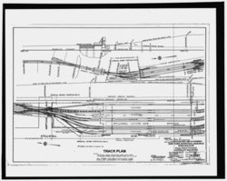
Each line has its own pair of tracks and a pair of double switches between these tracks, and each service has its own island platform serving these tracks. In regular operation, no service needs to cross over the tracks of another service. The tracks are numbered sequentially from east to west, with the N train at tracks 1 and 2; the Q at tracks 3 and 4; the F at tracks 5 and 6; and the D at tracks 7 and 8.[8] Tracks 1-6 can serve trains coming from both the north and south, while tracks 7-8 can only serve trains from the north, since they terminate at bumper blocks at the station's south end.[8][55] Until 1954, track 2 ended at a bumper block to the south, while track 7 merged with track 6 at the south end of the station.[55]
Though designed as a through station, service has rarely been provided between tracks. Aside from service changes, only two services have been scheduled to run through the station. These brief services ran as follows:
- 7 Brighton–Franklin service, via the BMT Franklin Avenue Line and BMT Brighton Line, through Stillwell Avenue to Manhattan (summer Sundays 1924–1952)[56][57]
- NX Sea Beach "super-express" service (rush hours 1967–1968)[58][59]
North of the station, tracks 7 and 6 merge into one track (with a switch from track 7 to track 8), tracks 5 through 2 merge into another track, and tracks 1 and 8 stay separate, so that there is a four-tracked structure when the BMT West End Line and BMT Sea Beach Line cross the Coney Island Creek. Before the structure crosses the creek, all four tracks have switches that connect the tracks to each other, before the West End and Sea Beach Lines split. Tracks from these lines then lead into Coney Island Yard.[8] South of the station, tracks 4, 5, and 6 stay separate from the other tracks (with a pair of switches between tracks 5 and 6) and tracks 1, 2, and 3 merge and have a diamond crossover with track 4. Tracks 3 and 4 (the Brighton Line tracks) are above tracks 5 and 6 (the Culver Line tracks) at this point.[8]
Bus terminal[]

Located underneath the subway station terminal is a set of bus stops that loop on Stillwell Avenue and Mermaid Avenue that make up a bus terminal for four New York City Bus lines. The bus terminal provides easier transfer to the subway and bus connections. One additional bus line is located near the station complex.[51][60]

| Lane | Route | Terminus[60] |
|---|---|---|
| North side opposite station entrance |
B68 | Windsor Terrace Bartel Pritchard Square |
| B82 Local |
Starrett City Pennsylvania Avenue and Seaview Avenue | |
| Station entrance | B74 | Sea Gate West 37th Street and Mermaid Avenue |
| B64, B68, B74, B82 |
Coney Island–Stillwell Avenue Terminating buses; drop-off only | |
| Stillwell Avenue and Mermaid Avenue (Western side) |
B64 | Bay Ridge Shore Road and 71st Street |
| Stillwell Avenue and Surf Avenue |
B36 | Westbound: Sea Gate West 37th Street and Surf Avenue |
| Eastbound: Sheepshead Bay Avenue U and Nostrand Avenue |
Subway–bus transfer coordination[]
To reduce missed connections and waiting time between the B36 and B82 buses and the Q route, New York City Transit began operating yellow holding lights to signal bus operators to wait for imminently arriving trains. The lights, which began operating March 10, 2014, are on the northeast corner of Surf and Stillwell Avenues and in the Mermaid Avenue Bus Loop. This system operates during late nights, from 11:00 p.m. to 5:00 a.m. daily.[61]
Nearby points of interest[]

The station is located across Surf Avenue from the Coney Island amusement area. It is close to the Luna Park amusement park, formerly the site of Astroland;[51] the Scream Zone area, operated by Luna Park;[51] Deno's Wonder Wheel Amusement Park;[10][51] the Cyclone[10][47][51] and Thunderbolt roller coasters;[51] and the amusement area on the site of Steeplechase Park, which includes the B&B Carousell.[51] Other nearby attractions include the original Nathan's Famous store and the Riegelmann Boardwalk along the Atlantic Ocean.[47][51] The New York Aquarium is a few blocks to the east, though the West Eighth Street–New York Aquarium station is closer to the aquarium than the Stillwell Avenue station is.[51]
Slightly to the west is Maimonides Park, home park of the Brooklyn Cyclones, a minor league baseball team. [51][47] The nearby area also has assorted amusement park attractions, such as bumper cars, carousels, and ice skating rinks, especially along Surf Avenue.[62] The Parachute Jump, a former parachute-drop ride later converted into a lighted tower,[63] is nearby and visible from the station.[51] In addition, the seasonal Coney Island Mermaid Parade is held every summer near the station.[47][64] The Nathan's Hot Dog Eating Contest, held on July 4 each year, also takes place at the Nathan's shop, diagonally across the intersection of Surf and Stillwell Avenues on the southwest corner.[65][66] The former Shore Theater is located on the northwest corner of that intersection, west of the station and north of Nathan's Famous.[51]
References[]
- ^ "Glossary". Second Avenue Subway Supplemental Draft Environmental Impact Statement (SDEIS) (PDF). 1. Metropolitan Transportation Authority. March 4, 2003. pp. 1–2. Archived from the original (PDF) on February 26, 2021. Retrieved January 1, 2021.
- ^ a b "OPEN FIRST SECTION OF BROADWAY LINE; Train Carrying 1,000 Passengers Runs from Fourteenth Street to Coney Island.REGULAR SERVICE BEGINSNew Road Is Expected to Relieve Old System of 15,000 PersonsDaily in Rush Hours. Service Commissioners Jubliant. Schedule Not Fully Arranged". The New York Times. September 5, 1917. ISSN 0362-4331. Retrieved August 15, 2016.
- ^ a b c d e f g h Stanton, Jeffrey (June 2, 1998). "Coney Island History -Development of Rail and Steamboat Lines to the resort". www.westland.net. Westland. Retrieved August 15, 2016.
- ^ a b "New York City Transit — History and Chronology". mta.info. Retrieved August 15, 2016.
The newly renovated Stillwell Avenue Terminal reopens and train service returns to Coney Island after a 21-month hiatus during construction
- ^ "Station Developers' Information". Metropolitan Transportation Authority. Retrieved June 13, 2017.
- ^ "Facts and Figures: Annual Subway Ridership 2014–2019". Metropolitan Transportation Authority. 2020. Retrieved May 26, 2020.
- ^ a b "Facts and Figures: Annual Subway Ridership 2014–2019". Metropolitan Transportation Authority. 2020. Retrieved May 26, 2020.
- ^ a b c d e Dougherty, Peter (2006) [2002]. Tracks of the New York City Subway 2006 (3rd ed.). Dougherty. OCLC 49777633 – via Google Books.
- ^ a b Huneke, Arthur John. "WEST END LINE". www.arrts-arrchives.com. Retrieved August 15, 2016.
- ^ a b c d e f g Walsh, Kevin (August 2002). "OLD STILLWELL AVE. TERMINAL — Forgotten New York". forgotten-ny.com. Forgotten NY. Retrieved August 15, 2016.
- ^ a b Matus, Paul (May 2003). "The New BMT Coney Island Terminal". thethirdrail.net. p. 1. Archived from the original on October 17, 2016. Retrieved August 15, 2016.
- ^ a b Matus, Paul (May 2003). "The New BMT Coney Island Terminal". thethirdrail.net. p. 2. Archived from the original on June 29, 2013. Retrieved August 15, 2016.
- ^ Huneke, Arthur John. "Coney Island CULVER Terminal". www.arrts-arrchives.com. Retrieved August 15, 2016.
- ^ a b "An Improved Terminal For Handling the Heavy Coney Island Crowds–Brooklyn Rapid Transit Company". Street Railway Journal. McGraw Publishing Company. 23 (24): 884–888. June 11, 1904. Retrieved September 4, 2016.
- "The Brooklyn Rapid Transit's New Culver Terminal". Brooklyn Daily Eagle. May 15, 1904. p. 8. Retrieved September 2, 2016 – via Newspapers.com.
- "The Rehabilitation of the Brooklyn Rapid Transit Company". Railroad Gazette. 42 (20): 670–673. May 17, 1907. Retrieved September 2, 2016.
- Feinman, Mark S. (February 17, 2001). "www.nycsubway.org: Early Rapid Transit in Brooklyn, 1878–1913". www.nycsubway.org. Retrieved November 12, 2015.
- ^ "Norton's Point Trolley". Forgotten New York. October 1999. Retrieved September 22, 2019.
- ^ a b c d e Matus, Paul (May 2003). "The New BMT Coney Island Terminal". thethirdrail.net. p. 4. Archived from the original on March 3, 2016. Retrieved August 15, 2016.
- ^ a b c Hoffman, Laura J. (June 9, 2014). Coney Island. Arcadia Publishing. p. 87. ISBN 9781467121316.
- ^ a b c d e f g h "Stillwell Terminal Remains a Sparkling Jewel a Decade after Full Rehabilitation". www.mta.info. Metropolitan Transportation Authority. May 20, 2014. Retrieved August 15, 2016.
- ^ Walsh, Kevin (February 2001). "THE NEW YORK STUBWAYS. Remnants of long-gone elevated lines". forgotten-ny.com. Forgotten New York. Retrieved August 15, 2016.
- ^ a b "CONEY FARE CUT SATURDAY.; One Nickel to Take Passenger Over Lines of the B.R.T." The New York Times. April 28, 1920. ISSN 0362-4331. Retrieved August 15, 2016.
- ^ a b "5-CENT FARE TO CONEY.; Change Is Effective Today on B.R. T. Elevated and Subway Lines". The New York Times. May 1, 1920. ISSN 0362-4331. Retrieved August 15, 2016.
- ^ "Weather Subdues Police of BRT". fultonhistory.com. Brooklyn Standard Union. January 18, 1923. Retrieved August 15, 2016.
- ^ "New Entrance Planned For West End Terminal". Brooklyn Daily Eagle. February 19, 1929. Retrieved August 15, 2016 – via newspapers.com.
- ^ "NEW B.M.T. SERVICE.; Brighton-Franklin Trains to Coney Island to Run Weekdays". The New York Times. June 25, 1933. ISSN 0362-4331. Retrieved August 16, 2016.
- ^ "NORTONS POINT TROLLEY, Brooklyn". Forgotten New York. March 3, 2012. Retrieved August 16, 2016.
- ^ "The Norton's Point Trolley Ramp". Coney Island History Project. May 4, 2009. Retrieved August 16, 2016.
- ^ "BRONX TO CONEY RIDE IN NEW SUBWAY LINK". The New York Times. October 18, 1954. ISSN 0362-4331. Retrieved August 16, 2016.
- ^ a b Matus, Paul (May 2003). "The New BMT Coney Island Terminal". thethirdrail.net. p. 5. Archived from the original on March 10, 2016. Retrieved August 15, 2016.
- ^ "Coney Bus Fare Protested". The New York Times. April 23, 1956. ISSN 0362-4331. Retrieved August 16, 2016.
- ^ a b The Bulletin, New York Division Electric Railroaders' Association, January 1987, page 5.
- ^ "Coney wins one-fare plan on 2 routes". New York Daily News. November 7, 1980. p. 434. Retrieved July 22, 2019 – via newspapers.com
 .
.
- ^ Perlmutter, Emanuel (April 14, 1965). "Subway Cars Here To Get Strip Maps Showing One Route; New Series of Maps, Signs and Schedules Are Designed to Take the Guesswork Out of Subway Travel". The New York Times. ISSN 0362-4331. Retrieved August 16, 2016.
- ^ "The Diamond Jubilee Brings Optimism". www.nycsubway.org. Retrieved August 15, 2016.
- ^ a b c d e f g h i j k l m n Chan, Sewell (May 28, 2005). "And Now for the Good News From the Subway System". The New York Times. ISSN 0362-4331. Retrieved August 15, 2016.
- ^ Glave, Judie (September 2, 1990). "Coney Island stages a comeback". The Journal-News. White Plains, NY. pp. 68, 69, 70 – via newspapers.com .
- ^ Judith N. DeSena; Timothy Shortell (2012). The World in Brooklyn: Gentrification, Immigration, and Ethnic Politics in a Global City. Lexington Books. pp. 147–176. ISBN 978-0-7391-6670-3.
- ^ a b c d e Matus, Paul (May 2003). "The New BMT Coney Island Terminal". thethirdrail.net. p. 6. Archived from the original on October 17, 2016. Retrieved August 15, 2016.
- ^ a b Liff, Bob (June 8, 1999). "SPRUCEUP FOR STILLWELL – 125M PLAN FOR CONEY TERMINAL". nydailynews.com. New York Daily News. Retrieved August 16, 2016.
- ^ NYC Transit Committee Agenda May 1994. New York City Transit. May 16, 1994.
- ^ a b c Bahrampour, Tara (August 25, 2002). "NEIGHBORHOOD REPORT: CONEY ISLAND; Trek to Beach Will Get Harder as Station Gets a Face-Lift". The New York Times. Retrieved August 15, 2016.
- ^ "Noteworthy – N restored to Coney Island". May 7, 2005. Archived from the original on May 7, 2005. Retrieved September 18, 2016.CS1 maint: bot: original URL status unknown (link)
- ^ Kabak, Benjamin (June 2, 2010). "At Coney Island, a new sign for the next train". secondavenuesagas.com. Second Avenue Sagas. Retrieved August 15, 2016.
- ^ a b c d e f g h Cox, Jeremiah. "Coney Island-Stillwell Avenue (D,F,N,Q) – The SubwayNut". www.subwaynut.com. Retrieved August 15, 2016.
- ^ a b Spellen, Suzanne (August 11, 2010). "Coney Island Brooklyn". Brownstoner. Retrieved August 16, 2016.
- ^ Matus, Paul (May 2003). "The New BMT Coney Island Terminal". thethirdrail.net. p. 7. Retrieved August 16, 2016.
- ^ a b "Coney Island-Stillwell Avenue: Robert Wilson: My Coney Island Baby, 2004". web.mta.info. Metropolitan Transportation Authority. Retrieved August 15, 2016.
- ^ a b c d e Knoke, Kyle (May 1, 2015). Subway Adventure Guide: New York City: To the End of the Line. Triumph Books. ISBN 9781629370774.
- ^ a b c d e Goodrich, John (September 8, 2005). "Fun House Meets Bauhaus". The New York Sun. Retrieved August 16, 2016.
- ^ "Stillwell Avenue Portal Building". ddp-ny.com. di Domenico + Partners. Archived from the original on October 17, 2016. Retrieved August 16, 2016.
- ^ "Whimsy Still Reigns in Coney Island". info.aia.org. American Institute of Architects. August 29, 2005. Retrieved August 16, 2016.
- ^ a b c d e f g h i j k l m n o "MTA Neighborhood Maps: Coney Island" (PDF). mta.info. Metropolitan Transportation Authority. 2015. Retrieved August 15, 2016.
- ^ "NYPD — Transit District 34". www.nyc.gov. Archived from the original on August 25, 2016. Retrieved August 15, 2016.
- ^ a b c d e "Coney Island's Stillwell Avenue Station is Covered with 2,730 Identical Solar Panels". Untapped Cities. October 22, 2013. Retrieved August 15, 2016.
- ^ Maniscalco, Joe (June 15, 2010). "Power outage! Coney station's solar array is fueling disappointment". brooklynpaper.com. Brooklyn Paper. Retrieved August 15, 2016.
- ^ a b "BRIGHTON LINE TRACK PLANS BRIGHTON LINE TRACK PLANS" (PDF). Electric Railroaders' Association Bulletin. 46 (7): 5. July 2003. Archived from the original (PDF) on September 7, 2018. Retrieved April 10, 2018.
- ^ "The Third Rail — The New Franklin Shuttle — Preface". www.thethirdrail.net. Archived from the original on March 14, 2016. Retrieved June 21, 2016.
- ^ Cudahy, Brian J. (January 1, 1999). The Malbone Street Wreck. Fordham Univ Press. ISBN 9780823219322.
- ^ Perlmutter, Emanuel (November 16, 1967). "SUBWAY CHANGES TO SPEED SERVICE: Major Alterations in Maps, Routes and Signs Will Take Effect Nov. 26" (PDF). The New York Times. Retrieved July 7, 2015.
- ^ Bernstein, Karl. "Brooklyn Brooklyn to the Bronx Zoo by the Coney Island Express and Third Avenue el". MyRecollection.com. Archived from the original on August 6, 2003. Retrieved August 15, 2016.
- ^ a b "Brooklyn Bus Map" (PDF). Metropolitan Transportation Authority. October 2020. Retrieved December 1, 2020.
- ^ "Holding the Bus for Trains at Coney Island". www.mta.info. Metropolitan Transportation Authority. March 7, 2014. Retrieved August 14, 2016.
- ^ "Tourist Information". coneyisland.com. Coney Island USA. Retrieved August 17, 2016.
- ^ Bredderman, Will (June 28, 2013). "Here's the bling: New, brighter lights for Parachute Jump". Brooklyn Paper. Archived from the original on July 20, 2019. Retrieved July 20, 2019.
- ^ "Coney Island Mermaid Parade: Photos, preview and more information". New York's PIX11 / WPIX-TV. June 17, 2016. Retrieved August 17, 2016.
- ^ "ESPN Locks In Hot Dog Eating Contest through 2024". Chicago Tribune. Retrieved March 10, 2017.
- ^ "Nathan's Famous Contest is Fourth of July Marketing Magic". Forbes.com. Retrieved March 10, 2017.
External links[]
| External images | |
|---|---|
| Wikimedia Commons has media related to Coney Island – Stillwell Avenue (New York City Subway). |
- nycsubway.org – Station: Coney Island/Stillwell Avenue
- The Subway Nut — Coney Island–Stillwell Avenue Pictures
- MTA's Arts For Transit — Coney Island–Stillwell Avenue
- Historic American Engineering Record (HAER) No. NY-325, "Stillwell Avenue Station, Intersection of Stillwell & Surf Avenues, Brooklyn, Kings County, NY", 53 photos, 40 data pages, 6 photo caption pages
Station Reporter:
Google Maps Street View
MTA Regional Bus Operations | ||
|---|---|---|
| Routes |
|   |
| Fleet |
| |
| Transit hubs |
| |
| Other |
| |
Coney Island | |||||||
|---|---|---|---|---|---|---|---|
Brooklyn, New York City | |||||||
| Parks |
|   | |||||
| Roller coasters |
| ||||||
| Other rides |
| ||||||
| Other attractions |
| ||||||
| Defunct |
| ||||||
| Community | |||||||
| Organizations | |||||||
| Neighborhoods |
| ||||||
| Subway stations | |||||||
| Cultural impact | |||||||
See also: Brooklyn Community Board 13 | |||||||
- Accessible New York City Subway stations
- 1919 establishments in New York City
- Coney Island
- BMT Brighton Line stations
- BMT Culver Line stations
- BMT Sea Beach Line stations
- BMT West End Line stations
- Historic American Engineering Record in New York City
- IND Culver Line stations
- New York City Subway stations in Brooklyn
- New York City Subway terminals
- New York City Subway stations located aboveground
- New York City Subway transfer stations
- Railway stations in the United States opened in 1919