Ocean Parkway station
Ocean Parkway | |||||||||||||||||||||||||||||||||||||||||||||||||||||||||||||||||||||||||||||||||||||||||||||||||||||||||||||||||||||||
|---|---|---|---|---|---|---|---|---|---|---|---|---|---|---|---|---|---|---|---|---|---|---|---|---|---|---|---|---|---|---|---|---|---|---|---|---|---|---|---|---|---|---|---|---|---|---|---|---|---|---|---|---|---|---|---|---|---|---|---|---|---|---|---|---|---|---|---|---|---|---|---|---|---|---|---|---|---|---|---|---|---|---|---|---|---|---|---|---|---|---|---|---|---|---|---|---|---|---|---|---|---|---|---|---|---|---|---|---|---|---|---|---|---|---|---|---|---|---|---|
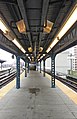
 View west from northbound platform | |||||||||||||||||||||||||||||||||||||||||||||||||||||||||||||||||||||||||||||||||||||||||||||||||||||||||||||||||||||||
| Station statistics | |||||||||||||||||||||||||||||||||||||||||||||||||||||||||||||||||||||||||||||||||||||||||||||||||||||||||||||||||||||||
| Address | Ocean Parkway & Brighton Beach Avenue Brooklyn, NY 11235 | ||||||||||||||||||||||||||||||||||||||||||||||||||||||||||||||||||||||||||||||||||||||||||||||||||||||||||||||||||||||
| Borough | Brooklyn | ||||||||||||||||||||||||||||||||||||||||||||||||||||||||||||||||||||||||||||||||||||||||||||||||||||||||||||||||||||||
| Locale | Brighton Beach | ||||||||||||||||||||||||||||||||||||||||||||||||||||||||||||||||||||||||||||||||||||||||||||||||||||||||||||||||||||||
| Coordinates | 40°34′35″N 73°58′07″W / 40.576252°N 73.968587°WCoordinates: 40°34′35″N 73°58′07″W / 40.576252°N 73.968587°W | ||||||||||||||||||||||||||||||||||||||||||||||||||||||||||||||||||||||||||||||||||||||||||||||||||||||||||||||||||||||
| Division | B (BMT)[1] | ||||||||||||||||||||||||||||||||||||||||||||||||||||||||||||||||||||||||||||||||||||||||||||||||||||||||||||||||||||||
| Line | BMT Brighton Line | ||||||||||||||||||||||||||||||||||||||||||||||||||||||||||||||||||||||||||||||||||||||||||||||||||||||||||||||||||||||
| Services | Q | ||||||||||||||||||||||||||||||||||||||||||||||||||||||||||||||||||||||||||||||||||||||||||||||||||||||||||||||||||||||
| Transit | |||||||||||||||||||||||||||||||||||||||||||||||||||||||||||||||||||||||||||||||||||||||||||||||||||||||||||||||||||||||
| Structure | Elevated | ||||||||||||||||||||||||||||||||||||||||||||||||||||||||||||||||||||||||||||||||||||||||||||||||||||||||||||||||||||||
| Platforms | 2 island platforms | ||||||||||||||||||||||||||||||||||||||||||||||||||||||||||||||||||||||||||||||||||||||||||||||||||||||||||||||||||||||
| Tracks | 4 (2 in regular service) | ||||||||||||||||||||||||||||||||||||||||||||||||||||||||||||||||||||||||||||||||||||||||||||||||||||||||||||||||||||||
| Other information | |||||||||||||||||||||||||||||||||||||||||||||||||||||||||||||||||||||||||||||||||||||||||||||||||||||||||||||||||||||||
| Opened | April 22, 1917 | ||||||||||||||||||||||||||||||||||||||||||||||||||||||||||||||||||||||||||||||||||||||||||||||||||||||||||||||||||||||
| Station code | 056[2] | ||||||||||||||||||||||||||||||||||||||||||||||||||||||||||||||||||||||||||||||||||||||||||||||||||||||||||||||||||||||
| Opposite- direction transfer | Yes | ||||||||||||||||||||||||||||||||||||||||||||||||||||||||||||||||||||||||||||||||||||||||||||||||||||||||||||||||||||||
| Traffic | |||||||||||||||||||||||||||||||||||||||||||||||||||||||||||||||||||||||||||||||||||||||||||||||||||||||||||||||||||||||
| 2019 | 1,033,340[4] | ||||||||||||||||||||||||||||||||||||||||||||||||||||||||||||||||||||||||||||||||||||||||||||||||||||||||||||||||||||||
| Rank | 357 out of 424[4] | ||||||||||||||||||||||||||||||||||||||||||||||||||||||||||||||||||||||||||||||||||||||||||||||||||||||||||||||||||||||
| Station succession | |||||||||||||||||||||||||||||||||||||||||||||||||||||||||||||||||||||||||||||||||||||||||||||||||||||||||||||||||||||||
| Next north | Brighton Beach (local): Q Brighton Beach (express): no regular service | ||||||||||||||||||||||||||||||||||||||||||||||||||||||||||||||||||||||||||||||||||||||||||||||||||||||||||||||||||||||
| Next south | West Eighth Street–New York Aquarium: Q | ||||||||||||||||||||||||||||||||||||||||||||||||||||||||||||||||||||||||||||||||||||||||||||||||||||||||||||||||||||||
| |||||||||||||||||||||||||||||||||||||||||||||||||||||||||||||||||||||||||||||||||||||||||||||||||||||||||||||||||||||||
| |||||||||||||||||||||||||||||||||||||||||||||||||||||||||||||||||||||||||||||||||||||||||||||||||||||||||||||||||||||||
| |||||||||||||||||||||||||||||||||||||||||||||||||||||||||||||||||||||||||||||||||||||||||||||||||||||||||||||||||||||||
| |||||||||||||||||||||||||||||||||||||||||||||||||||||||||||||||||||||||||||||||||||||||||||||||||||||||||||||||||||||||
Ocean Parkway Station (Dual System BRT) | |||||||||||||||||||||||||||||||||||||||||||||||||||||||||||||||||||||||||||||||||||||||||||||||||||||||||||||||||||||||
U.S. National Register of Historic Places | |||||||||||||||||||||||||||||||||||||||||||||||||||||||||||||||||||||||||||||||||||||||||||||||||||||||||||||||||||||||
| MPS | New York City Subway System MPS | ||||||||||||||||||||||||||||||||||||||||||||||||||||||||||||||||||||||||||||||||||||||||||||||||||||||||||||||||||||||
| NRHP reference No. | 05000749[5] | ||||||||||||||||||||||||||||||||||||||||||||||||||||||||||||||||||||||||||||||||||||||||||||||||||||||||||||||||||||||
| Added to NRHP | July 29, 2005 | ||||||||||||||||||||||||||||||||||||||||||||||||||||||||||||||||||||||||||||||||||||||||||||||||||||||||||||||||||||||


The Ocean Parkway station is an express station on the New York City Subway's BMT Brighton Line. It is located at Brighton Beach Avenue and Ocean Parkway in Brighton Beach, Brooklyn. The station is served by the Q train at all times.[6]
History[]

When the Ocean Parkway station opened on April 22, 1917, it was served only by a single-track shuttle that ran to Brighton Beach, which was the southern terminal for all trains on the Brighton Line.
When the West Eighth Street–New York Aquarium station opened in 1919, all four tracks were extended west to serve the two-level station. The local tracks remained at the same elevation and connected to the lower level (which was also served by the IND Culver Line) while the express tracks rose up and connected to the upper level. As a result, all Brighton Line service was extended to Coney Island–Stillwell Avenue.
A reconfiguration in 1954 resulted in the discontinuation of Brighton Line service on the lower level of West Eighth Street, as well as express service at Ocean Parkway. West of this station, the local tracks merge into the express tracks, which continue to serve the upper level of West Eighth Street. The structures connecting the Brighton Line to the lower level, which the Culver Line continues to serve, remain intact, but are trackless.
The station was closed in August 2002 in conjunction with the reconstruction of the Coney Island–Stillwell Avenue terminal.[7] Service was restored on May 23, 2004.[8]
Station layout[]

| P Platform level |
Northbound local | ← |
| Island platform | ||
| Northbound express | No regular service | |
| Southbound express | No regular service | |
| Island platform | ||
| Northbound local | | |
| M | Mezzanine | Fare control, station agent, MetroCard machines |
| G | Street level | Entrances/exits |
This elevated station has two curved island platforms and four tracks with the center express tracks not normally used.[9] It is built on a decorated masonry viaduct to keep with Ocean Parkway's status as a city parkway. Both platforms have red canopies with black frames and support columns along their entire length except for a section at their east (railroad north) end.
The station is geographically the closest Brighton Line station to the Brighton and Coney Island beaches, with the beachfront located roughly 500 feet (150 m) away from the station.
The 1996 artwork here is called Coney Island Reliefs by Deborah Masters. It was installed in 2009 and consists of 128 reliefs on the station's concrete structure.
Between this station and Brighton Beach, two layup tracks begin at bumper blocks adjacent to the platforms and run between the local and express tracks, making this section the only six-track elevated structure in the subway system. The two tracks merge with either adjacent track on approach to Brighton Beach.[9]
Exits[]
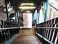
This station has two entrances/exits, both of which are elevated station houses beneath the tracks and platforms.
- The full-time one is at the east end. A single staircase from each platform goes down to a waiting area/crossunder, where a turnstile bank provides entrance/exit from the station. Outside fare control, there is a token booth and two staircases going down to each eastern corner of Brighton Beach Avenue and Ocean Parkway.[10]
- The other station house at the west end also has one staircase from each platform, a waiting area/crossunder, and two staircases facing in opposite directions and going down to the northwest corner of Brighton Beach Avenue and Ocean Parkway. However, it is un-staffed, containing two High Entry/Exit Turnstiles.[10]
Gallery[]
Looking eastward, toward Brighton Beach station

From northbound platform, looking toward Coney Island
From northbound platform, looking eastward

Driver cab's view, made during the Brighton train parade
One of the station entrances


References[]
- ^ "Glossary". Second Avenue Subway Supplemental Draft Environmental Impact Statement (SDEIS) (PDF). Vol. 1. Metropolitan Transportation Authority. March 4, 2003. pp. 1–2. Archived from the original (PDF) on February 26, 2021. Retrieved January 1, 2021.
- ^ "Station Developers' Information". Metropolitan Transportation Authority. Retrieved June 13, 2017.
- ^ "Facts and Figures: Annual Subway Ridership 2014–2019". Metropolitan Transportation Authority. 2020. Retrieved May 26, 2020.
- ^ a b "Facts and Figures: Annual Subway Ridership 2014–2019". Metropolitan Transportation Authority. 2020. Retrieved May 26, 2020.
- ^ "NPS Focus". National Register of Historic Places. National Park Service. Retrieved December 12, 2011.
- ^ "Q Subway Timetable, Effective November 8, 2020" (PDF). Metropolitan Transportation Authority. Retrieved December 9, 2020.
- ^ Bahrampour, Tara (2002-08-25). "NEIGHBORHOOD REPORT: CONEY ISLAND; Trek to Beach Will Get Harder as Station Gets a Face-Lift". The New York Times. ISSN 0362-4331. Retrieved 2020-03-14.
- ^ Chan, Sewell (2005-05-28). "And Now for the Good News From the Subway System". The New York Times. ISSN 0362-4331. Retrieved 2020-03-14.
- ^ a b Dougherty, Peter (2006) [2002]. Tracks of the New York City Subway 2006 (3rd ed.). Dougherty. OCLC 49777633 – via Google Books.
- ^ a b "MTA Neighborhood Maps: Sheepshead Bay" (PDF). mta.info. Metropolitan Transportation Authority. 2015. Retrieved 2 August 2015.
External links[]
| Wikimedia Commons has media related to Ocean Parkway (BMT Brighton Line). |
- nycsubway.org – BMT Brighton Line: Ocean Parkway
- Station Reporter — Q Train
- The Subway Nut — Ocean Parkway Pictures
- Brighton Beach Avenue entrance from Google Maps Street View
- West Brighton Avenue entrance from Google Maps Street View
- Platforms from Google Maps Street View
Broadway Express/ Brighton Local |
|
|---|---|
| |
| Brighton Line |
|
|---|---|
| |
Coney Island | |||||||
|---|---|---|---|---|---|---|---|
Brooklyn, New York City | |||||||
| Parks |
|   | |||||
| Roller coasters |
| ||||||
| Other rides |
| ||||||
| Other attractions | |||||||
| Defunct |
| ||||||
| Community | |||||||
| Organizations | |||||||
| Neighborhoods |
| ||||||
| Subway stations | |||||||
| Cultural impact | |||||||
See also: Brooklyn Community Board 13 | |||||||
U.S. National Register of Historic Places in New York | ||
|---|---|---|
| Topics |  | |
| Lists by county |
| |
| Lists by city | ||
| Other lists | ||
| ||
- BMT Brighton Line stations
- Railway and subway stations on the National Register of Historic Places in New York City
- New York City Subway stations in Brooklyn
- New York City Subway stations located aboveground
- Railway stations in the United States opened in 1917
- 1917 establishments in New York City
- Brighton Beach
- National Register of Historic Places in Brooklyn