Briarwood station
Briarwood | |||
|---|---|---|---|
 Eastbound platform | |||
| Station statistics | |||
| Address | Main Street & Queens Boulevard Queens, NY 11435 | ||
| Borough | Queens | ||
| Locale | Briarwood | ||
| Coordinates | 40°42′35″N 73°49′11″W / 40.70969°N 73.8196°WCoordinates: 40°42′35″N 73°49′11″W / 40.70969°N 73.8196°W | ||
| Division | B (IND)[1] | ||
| Line | IND Queens Boulevard Line | ||
| Services | E F | ||
| Transit | |||
| Structure | Underground | ||
| Platforms | 2 side platforms | ||
| Tracks | 4 | ||
| Other information | |||
| Opened | April 24, 1937[2] | ||
| Station code | 258[3] | ||
| Accessible | |||
| Accessibility | Same-platform wheelchair transfer available | ||
| Opposite- direction transfer | No | ||
| Former/other names | Van Wyck Boulevard (1937–1998) Briarwood–Van Wyck Boulevard (1998–2015) | ||
| Traffic | |||
| 2019 | 1,501,152[5] | ||
| Rank | 298 out of 424[5] | ||
| Station succession | |||
| Next east | Sutphin Boulevard: E Jamaica–Van Wyck (Archer): E | ||
| Next west | Kew Gardens–Union Turnpike: E | ||
| |||
| |||
| |||
| |||


Briarwood (formerly Briarwood–Van Wyck Boulevard or Van Wyck Boulevard) is a local station on the IND Queens Boulevard Line of the New York City Subway. Located at the intersection of 84th Drive, Main Street, Queens Boulevard, and the Van Wyck Expressway, in Briarwood, Queens, bordering Kew Gardens, it is served by the F train at all times, the E train at all times except rush hours and middays, and the <F> train during rush hours in the peak direction.
This station opened on April 24, 1937 as part of an extension of the Independent Subway System's Queens Boulevard Line. It has been renovated multiple times to accommodate the construction of and modifications to the Van Wyck Expressway.
History[]
Construction[]
The Queens Boulevard Line was one of the first built by the city-owned Independent Subway System (IND), and was planned to stretch between the IND Eighth Avenue Line in Manhattan and 178th Street and Hillside Avenue in Jamaica, Queens.[6][7] The line was first proposed in 1925.[8] Construction of the line was approved by the New York City Board of Estimate on October 4, 1928.[9] Approval of the section of the Queens Boulevard Line between the intersections of 137th Street (now the Van Wyck Expressway) and Hillside Avenue was held up by a month during late 1929 because of a dispute over a spur that would run south to Rockaway Boulevard. Some property owners wanted the spur to run under Van Wyck Boulevard, while others wanted it to run under Sutphin Boulevard to the east.[10] On December 23, 1930, the contract for the construction of the section between 137th Street and 178th Street—Route 108, Section 11—was let. This section included the stations at 169th Street, Parsons Boulevard, Sutphin Boulevard, and Van Wyck Boulevard.[11] The contract for this section was awarded to Triest Contracting Corporation.[12] The line was constructed using the cut-and-cover tunneling method, and to allow pedestrians to cross, temporary bridges were built over the trenches.[13]
The first section of the line opened on August 19, 1933 from the connection to the Eighth Avenue Line at 50th Street to Roosevelt Avenue in Jackson Heights.[14] Later that year, a $23 million loan was approved to finance the remainder of the line, along with other IND lines.[15] The remainder of the line was built by the Public Works Administration.[16] In summer 1933 work on this station and 169th Street were completed, far ahead of schedule.[12] In 1934 and 1935, construction of the extension to Jamaica was suspended for 15 months and was halted by strikes.[17] Construction was further delayed due to a strike in 1935, instigated by electricians opposing wages paid by the General Railway Signal Company.[18]
In August 1936, tracks were installed all the way to 178th Street, and the stations to Union Turnpike were completed. However, the stops to the east, including Van Wyck Boulevard, still needed to be tiled and did not have stairways, turnstiles and lighting installed.[17] Two additional contracts remained to be put up for bid, both the results of last minute changes; one such contract involved moving the eastern terminal from 178th to 169th Street.[19] In addition, a new tunnel roof and new side supports had to be constructed.[20] A 3.5-mile (5.6 km) extension from Roosevelt Avenue to Kew Gardens opened on December 31, 1936.[21] In March 1937, the extension to 169th Street was expected to be opened on May 1, requiring work to be finished by April 3, and fully approved and tested by April 20. As of this point, minor station work remained, including the installation of light bulbs, with the only major work left to be completed being the final 200 feet (61 m) of track in the 169th Street terminal.[20]
Opening[]
On April 9, 1937, Mayor Fiorello La Guardia announced that the operation of the $14.4 million extension to Jamaica and express service would begin on April 24. The extension to Hillside Avenue and 178th Street, with a terminal station at 169th Street, opened as planned on April 24, 1937.[22][23][2] Service was initially provided by E trains, which began making express stops from 71st–Continental Avenues to Queens Plaza during rush hours on the same date, and by EE local trains during non-rush hours. The express service operated between approximately 6:30 and 10:30 a.m. and from 3:00 p.m. to 7:00 p.m.,[16][24] and ran every three to five minutes.[25] This extension was celebrated with a ribbon-cutting ceremony at the Parsons Boulevard station and with a parade along Hillside Avenue.[26]
Changes[]
Archer Avenue changes[]
Before the Archer Avenue lines opened on December 11, 1988, all Queens Boulevard express trains (E and F trains) ran to 179th Street. The E ran express east of 71st Avenue during rush hours only, and the F ran local east of 71st Avenue.[27]
In conjunction with the opening of the Archer Avenue lines, service patterns were changed. E trains were rerouted via the new line, running to Jamaica Center, via the Queens Boulevard Line's express tracks, and began running express east of 71st Avenue.[27][28] However, some E trains continued to run from 179th Street as expresses during the morning rush hour.[29]: 9–10 Service at local stations, such as Briarwood–Van Wyck Boulevard, was replaced by the R, which was extended to 179th Street from Continental Avenue. The R extension allowed F trains to continue running express to 179th Street.[30][31] The changes in subway service angered riders at local stations east of 71st Avenue because they lost direct Queens Boulevard Express service. Local elected officials pressured the MTA to eliminate all-local service at these stations.[32] On September 30, 1990, the R was cut back to 71st Avenue outside of rush hours. Local service to 179th Street was replaced by F trains, which provided Queens Boulevard Express service, during middays, evenings, and weekends, and local G service during late nights.[33] In 1992, the MTA decided to have F trains run local east of 71st Avenue on a six-month trial basis to replace R service, which would be cut back to 71st Avenue at all times.[34] The test started on October 26, 1992 and was implemented on a permanent basis six months later, eliminating express service along Hillside Avenue.[35][36]
2010s renovations[]
The station's exits were rebuilt as part of the $147 million Kew Gardens Interchange reconstruction project, which includes bridge replacement of the Queens Boulevard overpass over Van Wyck Expressway. The contract for reconstruction of the station's exit was bid on and won by Ecco and cost $9.9 million.[37] In 2011, the north entrance was demolished as part of rebuilding the interchange, leaving the southern exit bordering Maple Grove Cemetery as the sole entrance and exit.[38] A new entrance was built next to Archbishop Molloy High School on Main Street; another exit on the same site had been closed since 2010.[39] Another new entrance currently exists on the south side of Queens Boulevard between the Van Wyck Expressway service and main roads.
The station renovation was started in 2010 and was to be completed by 2016, with a new elevator entrance and rebuilt, widened mezzanine corridors.[39] However, delays abounded, including the fact that the new Main Street exit was delayed, having been pushed back from August 2012, to October 2013, and then again to March 2014; lead paint needed to be removed, costing $300,000; and plans were changed during construction, costing $1.7 million.[40] The opening of the new Main Street exit was subsequently pushed forward to February 2014, then back again to May 2014 with elevator work to begin after the new entrance opened; the elevator was to be complete by late 2014 or early 2015.[41] A new staircase entrance, on the northwest corner of Queens Boulevard and Main Street, was opened in December 2014.[42] In May 2017, officials opened the new elevator entrance, which is next to the staircase entrance that opened in December 2014. The elevator runs only between the street and mezzanine with no additional elevators or ramps to the platforms, so it is not ADA-accessible.[43]
In 2019, the Metropolitan Transportation Authority announced that this station would become ADA-accessible as part of the agency's 2020–2024 Capital Program.[44]
Station layout[]
| G | Street level | Exit/entrance |
| M | Mezzanine | Fare control, station agent, MetroCard machines Elevator at northwest corner of Queens Boulevard and Main Street. Note: Platforms are not accessible |
| P Platform level |
Side platform | |
| Southbound local | ← ← | |
| Southbound express | ← | |
| Northbound express | | |
| Northbound local | | |
| Side platform | ||
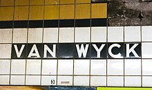
This local station, which is located directly under the Van Wyck Expressway's southbound service road, has four tracks and two side platforms.[45] The F train stops here at all times, while the E train uses the two center tracks to bypass this station weekdays (Manhattan-bound from approximately 6:00 a.m. to 6:30 p.m., Jamaica-bound from 7:30 a.m. to 8:00 p.m.).[46][47] The platforms have Slate blue I-beam columns, a Jasmine yellow tile trim with black borders, and name tablets reading "VAN WYCK BLVD." in white sans-serif lettering on a black background with a Jasmine yellow border. Small panels reading "BRIARWOOD" in white Copperplate font are centered underneath each name tablet; they were placed over the original directional exit tiling (in place at other IND stations) that pointed to Queens Boulevard or 85th Avenue, the latter of which has never existed. The small tile captions running below the trim line retain the original "VAN WYCK" name.
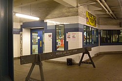
The full-length mezzanine is directly above the platforms; however the northern half was closed and The station mezzanine has hosted the NYPD Transit Bureau's District 20 station house since the mid-1990s. The open southern half is separated into three sections with chain-link fences; fare control is in the middle due to the need to have a pedestrian underpass under Queens Boulevard. As a result, there are no free transfers between directions.[48]
Exits[]


The full-time exit is via a long passageway to Main Street and Queens Boulevard, where there is an escalator and elevator to the north side of Queens Boulevard. The elevator leads only from the mezzanine level. Another pair of exits exists at the southwestern corner of Queens Boulevard and the Van Wyck Expressway service road, one on the west side of the service road next to Maple Grove Cemetery, the other on the east side of the service road adjoining the Van Wyck Expressway.[48]
Track layout[]
To the west of this station are track connections from both pairs of express and local tracks, which lead to Jamaica Yard.[49]
Just to the compass south (railroad north) of this station, the IND Archer Avenue Line splits from the Queens Boulevard Line in a flying junction; trains to/from the Archer Avenue line can serve the station as local trains or bypass it as express trains. At the split, the Archer Avenue tracks split from both pairs of express and local Queens Boulevard tracks. The connection uses trackways that were constructed at the same time as the station, part of the section of the Queens Boulevard Line from Kew Gardens–Union Turnpike to 169th Street.[49]
The provision (then known as the "Van Wyck Stub") was intended to be built as part of the IND Second System in the 1920s and 1930s. The original plans had a line diverging south of Briarwood, running down what is now the Van Wyck Expressway to Rockaway Boulevard near modern John F. Kennedy International Airport. The extension was never constructed due to lack of funding.[50] The current Archer Avenue plans emerged in the 1960s under the city and Metropolitan Transportation Authority (MTA)'s Program for Action. It was conceived as an expansion of Queens Boulevard service to a "Southeast Queens" line along the right-of-way of the Long Island Rail Road Atlantic Branch towards Locust Manor; a two-track spur from the Queens Boulevard Line would use the original Van Wyck Boulevard bellmouths.[51][50][52][53] However, the line was only completed to Jamaica Center–Parsons/Archer, and opened several years behind schedule in 1988.[54] There are punch boxes on the Jamaica-bound track of this station to allow trains to go to either the Hillside Avenue or Archer Avenue lines.
Naming[]

The station's original name was Van Wyck Boulevard. Van Wyck Boulevard was the name of the wide thoroughfare that existed when the station opened. The Van Wyck Expressway was built over the boulevard in the early 1950s. The name was changed to Briarwood–Van Wyck Boulevard in 1998[55] to avoid confusion with Jamaica–Van Wyck on the IND Archer Avenue Line.[56]
Since 2008, community members had been pushing to rename the station again to simply "Briarwood" since it better reflected the neighborhood of Briarwood, served by the station, and since "Van Wyck Boulevard" does not characterize the area well (the now-expressway runs through several other neighborhoods in Queens).[55] State Senator Tony Avella and local community groups pressed for the name change. The legislation, proposed in January 2013, passed the New York State Assembly on June 19, 2014.[57] In August 2014, it was announced that the station would be renamed Briarwood.[58] The station was formally renamed on April 17, 2015.[59][60]
In popular culture[]
In the 1988 comedy film Coming to America, Eddie Murphy's character, Akeem, tries to persuade his love interest to marry him and go to Zamunda, a fictional kingdom in Africa. He follows her onto the Briarwood station. When Akeem jumps the turnstile, "Van Wyck Boulevard" can be seen in the background above the token booth. They board the train which next stops at the Sutphin Boulevard station where she gets off.[61] This scene, however, was actually shot at the unused platform and tracks of Hoyt–Schermerhorn Streets station in Brooklyn.[citation needed]
References[]
- ^ "Glossary". Second Avenue Subway Supplemental Draft Environmental Impact Statement (SDEIS) (PDF). 1. Metropolitan Transportation Authority. March 4, 2003. pp. 1–2. Archived from the original (PDF) on February 26, 2021. Retrieved January 1, 2021.
- ^ Jump up to: a b "New Subway Link to Jamaica Opened; La Guardia, City Officials and Civic Groups Make Trial Run on 10-Car Train". The New York Times. April 25, 1937. ISSN 0362-4331. Retrieved March 8, 2019.
- ^ "Station Developers' Information". Metropolitan Transportation Authority. Retrieved June 13, 2017.
- ^ "Facts and Figures: Annual Subway Ridership 2014–2019". Metropolitan Transportation Authority. 2020. Retrieved May 26, 2020.
- ^ Jump up to: a b "Facts and Figures: Annual Subway Ridership 2014–2019". Metropolitan Transportation Authority. 2020. Retrieved May 26, 2020.
- ^ See:
- Duffus, R.L. (September 22, 1929). "Our Great Subway Network Spreads Wider; New Plans of Board of Transportation Involve the Building of More Than One Hundred Miles of Additional Rapid Transit Routes for New York". The New York Times. ISSN 0362-4331. Retrieved August 19, 2015.
- Board of Transportation of the City of New York Engineering Department, Proposed Additional Rapid Transit Lines And Proposed Vehicular Tunnel, dated August 23, 1929
- ^ "Queens Lauded as Best Boro By Chamber Chief". The Brooklyn Daily Eagle. September 23, 1929. p. 40. Retrieved October 4, 2015.
- ^ "New Subway Routes in Hylan Program to Cost $186,046,000" (PDF). The New York Times. 1925-03-21. p. 1. ISSN 0362-4331. Retrieved 2020-03-27.
- ^ "$17,146,500 Voted For New Subways; Estimate Board Appropriates More Than $9,000,000 for Lines in Brooklyn. $6,490,000 For The Bronx Smaller Items for Incidental Work --Approves the Proposed Queens Boulevard Route". The New York Times. October 5, 1928. ISSN 0362-4331. Retrieved August 4, 2016.
- ^ "Action on Queens Subway Delayed". Brooklyn Times-Union. November 14, 1929. p. 14. Retrieved October 4, 2015.
- ^ "178th Street Subway Stop Now Assured. Place Is Designated for Station by Transportation Board" (PDF). Long Island Daily Press. December 1, 1930. p. 1. Retrieved April 25, 2019.
- ^ Jump up to: a b "New Subway to Jamaica Ahead of Schedule Time". New York Daily News. September 17, 1933. Retrieved September 12, 2019.
- ^ Hirshon, Nicholas; Romano, Foreword by Ray (January 1, 2013). Forest Hills. Arcadia Publishing. ISBN 978-0-7385-9785-0.
- ^ "Two Subway Links Opened In Queens" (PDF). The New York Times. August 19, 1933. p. 13. ISSN 0362-4331. Retrieved December 11, 2016.
- ^ "Unfinished Sections of Subway Lines To Be Completed" (PDF). The New York Sun. December 13, 1933. p. 47. Retrieved July 30, 2016.
- ^ Jump up to: a b "Trains Testing Jamaica Link Of City Subway". The Brooklyn Daily Eagle. April 10, 1937. p. 3. Retrieved April 24, 2018.
- ^ Jump up to: a b Neufeld, Ernest (August 23, 1936). "Men Toil Under Earth to Build Subway" (PDF). Long Island Daily Press. p. 2 (Section 2). Retrieved August 12, 2016.
- ^ See:
- "500 More Quit Subway Work On Boulevard: General Strike Order Issued Today; 72 Walk Out in Jamaica" (PDF). Long Island Daily Press. April 2, 1935. p. 2. Retrieved July 30, 2016.
- "Aldermen Probe Strike on Subway" (PDF). Long Island Daily Press. April 3, 1935. p. 4. Retrieved July 30, 2016.
- ^ Neufeld, Ernest (August 23, 1936). "Men Toil Under Earth to Build Subway" (PDF). Long Island Daily Press. p. 2 (Section 2). Retrieved August 12, 2016.
- ^ Jump up to: a b "Two Crews Rush to Finish Last 200 Feet of Subwav: Work Must End April 3 to Allow Time for Tests" (PDF). Long Island Daily Press. March 19, 1937. p. 1. Retrieved April 25, 2019.
- ^ "City Subway Opens Queens Link Today". The New York Times. December 31, 1936. p. 3. ISSN 0362-4331. Retrieved April 26, 2016.
- ^ Kramer, Frederick A. (1990). Building the Independent Subway. Quadrant Press. ISBN 978-0-915276-50-9.
- ^
- "Subway Link Opens Soon: City Line to Jamaica Will Start About April 24" (PDF). The New York Times. March 17, 1937. ISSN 0362-4331. Retrieved June 27, 2015.
- "Trial Run to Jamaica on Subway Tomorrow: Section From Kew Gardens to 169th Street Will Open to Public in Two Weeks" (PDF). The New York Times. April 9, 1937. ISSN 0362-4331. Retrieved June 30, 2015.
- ^ "Jamaica Will Greet Subway" (PDF). The New York Sun. April 23, 1937. p. 8. Retrieved April 24, 2018.
- ^ "Transit Link Open Today; 8th Ave. Line Extended to Jamaica—Celebration Arranged". The New York Times. April 24, 1937. ISSN 0362-4331. Retrieved August 4, 2016.
- ^ "LaGuardia Heads Speakers Marking Subway Opening Ceremonies Planned Saturday Celebrating Hillside Avenue Extension" (PDF). North Shore Daily Journal. April 23, 2017. p. 3. Retrieved November 19, 2017.
- ^ Jump up to: a b Johnson, Kirk (December 9, 1988). "Big Changes For Subways Are to Begin". The New York Times. ISSN 0362-4331. Retrieved June 6, 2016.
- ^ Alternatives Analysis/Supplemental Draft Environmental Impact Statement for the Queens Subway Options Study. United States Department of Transportation, Metropolitan Transportation Authority, Urban Mass Transit Administration. May 1990. Retrieved August 13, 2016.
- ^ Archer Avenue Corridor Transit Service Proposal. New York City Transit Authority, Operations Planning Department. August 1988.
- ^ Polsky, Carol (December 11, 1988). "New Subway Line Finally Rolling Through Queens". Newsday.
- ^ "Archer Avenue Extension Opens December 11". Welcome Aboard: Newsletter of the New York City Transit Authority. New York City Transit Authority. 1 (4): 1. 1988.
- ^ "Service Change Monitoring Report Six Month Evaluation of F/R Queens Boulevard Line Route Restructure" (PDF). www.laguardiawagnerarchive.lagcc.cuny.edu. Metropolitan Transportation Authority. April 1993. Retrieved December 28, 2018.
- ^ "Service Changes September 30, 1990" (PDF). subwaynut.com. New York City Transit Authority. September 30, 1990. Archived from the original (PDF) on October 26, 2014. Retrieved May 1, 2016.
- ^ "Van Wyck Blvd Station" (PDF). www.laguardiawagnerarchive.lagcc.cuny.edu. Metropolitan Transportation Authority. May 1992. Retrieved December 28, 2018.
- ^ "October 1992 New York City Subway Map". Flickr. New York City Transit Authority. October 1992. Retrieved October 30, 2016.
- ^ "Service Change Monitoring Report Six Month Evaluation of F/R Queens Boulevard Line Route Restructure" (PDF). www.laguardiawagnerarchive.lagcc.cuny.edu. Metropolitan Transportation Authority. April 1993. Retrieved December 28, 2018.
- ^ Joe Marvilli (January 2, 2014). "Briarwood Construction End Date Pushed Back". Queens Tribune. Archived from the original on November 12, 2017. Retrieved August 27, 2014.
- ^ Melissa Chan. "Construction to close subway entrance". Queens Courier. Retrieved August 27, 2014.
- ^ Jump up to: a b Ewa Kern-Jedrychowska (May 28, 2013). "Entrance Slated To Open in Fall". DNA Info. Archived from the original on September 4, 2014. Retrieved August 27, 2014.
- ^ Ewa Kern-Jedrychowska (December 19, 2013). "Entrance Slated To Open in Fall". DNA Info. Archived from the original on September 4, 2014. Retrieved August 27, 2014.
- ^ Christopher Barca (January 23, 2014). "Subway station work continues in 2014". Queens Chronicle. Retrieved August 27, 2014.
- ^ Gannon, Michael (December 11, 2014). "Briarwood subway entrance now open". Queens Chronicle. Retrieved August 2, 2016.
- ^ Kern-Jedrychowska, Ewa (2017-05-01). "Residents Welcome Long-Delayed Elevator at Briarwood Subway Station". DNAinfo New York. Archived from the original on 2017-05-02. Retrieved 2017-05-05.
- ^ "Press Release - MTA Headquarters - MTA Announces 20 Additional Subway Stations to Receive Accessibility Improvements Under Proposed 2020-2024 Capital Plan". MTA. December 19, 2019. Retrieved December 20, 2019.
- ^ "Tracks of the New York City Subway". Tracks of the New York City Subway. Retrieved October 9, 2015.
- ^ "E Subway Timetable, Effective November 8, 2020" (PDF). Metropolitan Transportation Authority. Retrieved December 9, 2020.
- ^ "F Subway Timetable, Effective November 8, 2020" (PDF). Metropolitan Transportation Authority. Retrieved December 9, 2020.
- ^ Jump up to: a b "MTA Neighborhood Maps: Kew Gardens" (PDF). mta.info. Metropolitan Transportation Authority. 2015. Retrieved August 2, 2016.
- ^ Jump up to: a b "Tracks of the New York City Subway". Tracks of the New York City Subway. Retrieved October 9, 2015.
- ^ Jump up to: a b Raskin, Joseph B. (2013). The Routes Not Taken: A Trip Through New York City's Unbuilt Subway System. New York, New York: Fordham University Press. doi:10.5422/fordham/9780823253692.001.0001. ISBN 978-0-82325-369-2.
- ^ Burks, Edward C. (October 24, 1973). "Work Begun on Queens Subway Extension" (PDF). The New York Times. Retrieved September 26, 2015.
- ^ Archer Ave Route (proposed) Construction, Queens: Environmental Impact Statement. Urban Mass Transit Administration, United States Department of Transportation. August 1973. Retrieved August 6, 2016.
- ^ Dembart, Lee (September 9, 1977). "A Sentimental Journey on the BMT..." (PDF). The New York Times. Retrieved July 2, 2015.
- ^ Johnson, Kirk (December 9, 1988). "Big Changes For Subways Are to Begin". The New York Times. Retrieved July 5, 2009.
- ^ Jump up to: a b Kern-Jedrychowska, Ewa (March 17, 2014). "Change Could Be Next Stop for 'Briarwood/Van Wyck' Subway Station Name". DNAinfo New York. Archived from the original on August 21, 2016. Retrieved July 28, 2016.
- ^ A neighborhood association for the area in which the station lies campaigned for the name change in 1997 ("What's in a Name? All Aboard for Briarwood!". Newsday. April 13, 1997. Retrieved February 7, 2013.) A page on the Queens Boulevard line on New York City Subway Resources accessed in 1998 includes this phrase in the station's description: "This station has a new secondary name, Briarwood, that hasn't appeared on the map yet."
- ^ Barca, Christopher (August 7, 2014). "Briarwood station closer to renaming". Queens Chronicle. Retrieved August 23, 2014.
- ^ Greg Mocker (April 10, 2016). "Neighbors want the name of subway station changed". PIX11. Retrieved August 27, 2014.
- ^ "Briarwood-Van Wyck Boulevard Subway Station Gets Simpler Name". NY1. April 17, 2015. Retrieved April 22, 2015.
- ^ Suriel, Alina (April 17, 2015). "Briarwood station name shortened". Queens Courier. Retrieved April 22, 2015.
- ^ Schreil, Cristina (June 24, 2015). "Coming To America". Queens Chronicle. Retrieved April 28, 2016.
External links[]
| Wikimedia Commons has media related to Briarwood (IND Queens Boulevard Line). |
- nycsubway.org – IND Queens Boulevard Line: Briarwood/Van Wyck Boulevard
- Station Reporter—F Train
- The Subway Nut—Briarwood–Van Wyck Boulevard Pictures Archived 2018-01-05 at the Wayback Machine
- Former Queens Boulevard south side entrance from Google Maps Street View (now demolished)
- New Queens Boulevard entrance and elevator from Google Maps Street View
- New Van Wyck Expressway entrance (west side) from Google Maps Street View
- Van Wyck Expressway west service road entrance from Google Maps Street View
- Platforms from Google Maps Street View
- Future accessible New York City Subway stations
- 1937 establishments in New York (state)
- IND Queens Boulevard Line stations
- Kew Gardens, Queens
- New York City Subway stations in Queens, New York
- New York City Subway stations located underground
- Railway stations in the United States opened in 1937