Astoria–Ditmars Boulevard station
Astoria–Ditmars Blvd | ||||||||||||||||||||||||||||||||||||||||||||||||||||||||||||||||||||||||||||||||||
|---|---|---|---|---|---|---|---|---|---|---|---|---|---|---|---|---|---|---|---|---|---|---|---|---|---|---|---|---|---|---|---|---|---|---|---|---|---|---|---|---|---|---|---|---|---|---|---|---|---|---|---|---|---|---|---|---|---|---|---|---|---|---|---|---|---|---|---|---|---|---|---|---|---|---|---|---|---|---|---|---|---|---|
 | ||||||||||||||||||||||||||||||||||||||||||||||||||||||||||||||||||||||||||||||||||
| Station statistics | ||||||||||||||||||||||||||||||||||||||||||||||||||||||||||||||||||||||||||||||||||
| Address | 23rd Avenue, Ditmars Boulevard and 31st Street Astoria, NY 11105 | |||||||||||||||||||||||||||||||||||||||||||||||||||||||||||||||||||||||||||||||||
| Borough | Queens | |||||||||||||||||||||||||||||||||||||||||||||||||||||||||||||||||||||||||||||||||
| Locale | Astoria | |||||||||||||||||||||||||||||||||||||||||||||||||||||||||||||||||||||||||||||||||
| Coordinates | 40°46′34″N 73°54′39″W / 40.776089°N 73.910737°WCoordinates: 40°46′34″N 73°54′39″W / 40.776089°N 73.910737°W | |||||||||||||||||||||||||||||||||||||||||||||||||||||||||||||||||||||||||||||||||
| Division | B (BMT)[1] | |||||||||||||||||||||||||||||||||||||||||||||||||||||||||||||||||||||||||||||||||
| Line | BMT Astoria Line | |||||||||||||||||||||||||||||||||||||||||||||||||||||||||||||||||||||||||||||||||
| Services | N W | |||||||||||||||||||||||||||||||||||||||||||||||||||||||||||||||||||||||||||||||||
| Transit | ||||||||||||||||||||||||||||||||||||||||||||||||||||||||||||||||||||||||||||||||||
| Structure | Elevated | |||||||||||||||||||||||||||||||||||||||||||||||||||||||||||||||||||||||||||||||||
| Platforms | 1 island platform | |||||||||||||||||||||||||||||||||||||||||||||||||||||||||||||||||||||||||||||||||
| Tracks | 2 | |||||||||||||||||||||||||||||||||||||||||||||||||||||||||||||||||||||||||||||||||
| Other information | ||||||||||||||||||||||||||||||||||||||||||||||||||||||||||||||||||||||||||||||||||
| Opened | February 1, 1917 | |||||||||||||||||||||||||||||||||||||||||||||||||||||||||||||||||||||||||||||||||
| Station code | 001[2] | |||||||||||||||||||||||||||||||||||||||||||||||||||||||||||||||||||||||||||||||||
| Opposite- direction transfer | N/A | |||||||||||||||||||||||||||||||||||||||||||||||||||||||||||||||||||||||||||||||||
| Former/other names | Ditmars Avenue | |||||||||||||||||||||||||||||||||||||||||||||||||||||||||||||||||||||||||||||||||
| Traffic | ||||||||||||||||||||||||||||||||||||||||||||||||||||||||||||||||||||||||||||||||||
| 2019 | 5,277,341[3] | |||||||||||||||||||||||||||||||||||||||||||||||||||||||||||||||||||||||||||||||||
| Rank | 85 out of 424[3] | |||||||||||||||||||||||||||||||||||||||||||||||||||||||||||||||||||||||||||||||||
| Station succession | ||||||||||||||||||||||||||||||||||||||||||||||||||||||||||||||||||||||||||||||||||
| Next north | (Terminal): N | |||||||||||||||||||||||||||||||||||||||||||||||||||||||||||||||||||||||||||||||||
| Next south | Astoria Boulevard: N | |||||||||||||||||||||||||||||||||||||||||||||||||||||||||||||||||||||||||||||||||
| ||||||||||||||||||||||||||||||||||||||||||||||||||||||||||||||||||||||||||||||||||
| ||||||||||||||||||||||||||||||||||||||||||||||||||||||||||||||||||||||||||||||||||
| ||||||||||||||||||||||||||||||||||||||||||||||||||||||||||||||||||||||||||||||||||
| ||||||||||||||||||||||||||||||||||||||||||||||||||||||||||||||||||||||||||||||||||


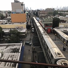
The Astoria–Ditmars Boulevard station (also known as Ditmars Boulevard station), is the northern terminal station on the BMT Astoria Line of the New York City Subway. Located above 31st Street between 23rd Avenue and Ditmars Boulevard in Astoria, Queens, it is served by the N train at all times and the W train on weekdays.
The Astoria–Ditmars Boulevard station opened on February 1, 1917, as part of the initial segment of the BMT Astoria Line. In 2018 and 2019, this station was renovated along with six others on the Astoria Line.
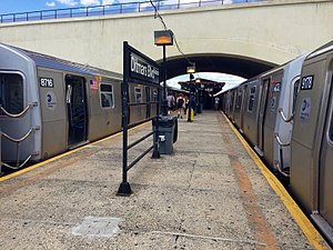
This station has two tracks and an island platform. It is partially under the New York Connecting Railroad (NYCR) viaduct, which also carries the tracks of Amtrak's Northeast Corridor. Most of the platform is north of the viaduct.
History[]
Opening[]
This station opened on February 1, 1917, along with the rest of the Astoria Line, which was originally part of the IRT, as a spur off the IRT Queensboro Line, now the IRT Flushing Line. Trains ran between Grand Central and Astoria.[4][5] Dignitaries from the first ride included President of Alderman Frank Dowling, Public Service Commissioner Hodges, numerous other officials of the commission, President Shonts of the IRT, with a number of his assistants, and Queens Borough President Connolly. Members of the PSC pointed out the need to extend the line from the terminal to Ditmars Boulevard and Steinway Street.[6] Regular passenger service started that afternoon.[6] The station's name was originally Ditmars Avenue, which was the name of Ditmars Boulevard at the station's opening.[6][7]
On July 23, 1917, the Queensboro Bridge spur of the elevated IRT Second Avenue Line opened. At that time, all elevated trains to Queensboro Plaza used the Astoria Line while all subway trains used the Corona Line, though this was later changed with trains alternating between branches.[5][8] This station started to be served by BMT shuttles using elevated cars on April 8, 1923.[9]
On October 17, 1949, the Astoria Line became BMT-only as the tracks at Queensboro Plaza were consolidated and the platforms on the Astoria Line were shaved back to allow through BMT trains to operate on it. Service was initially provided by the Brighton Local (BMT 1) weekdays & Broadway - Fourth Avenue Local (BMT 2) at all times.[10]
Renovations[]
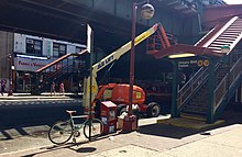
In 1981, the MTA listed the station among the 69 most deteriorated stations in the subway system.[11] In February 2018, the MTA announced that the station would be renovated for 14 months beginning in April of that year, as part of a $22 million project. The station house, mezzanine, and stairs would be repaired. Some residents protested, arguing that the renovated station would lack elevators, and that then-ongoing full closures of the 30th Avenue and 36th Avenue stations in Astoria had negatively impacted the community.[12]
There was a proposed, but never-built, extension of the line toward Bayside and possibly LaGuardia Airport.[13]
Station layout[]
| P Platform level |
Southbound | ← ← |
| Island platform | ||
| Southbound | ← ← | |
| M | Mezzanine | Fare control, station agent, MetroCard machines |
| G | Street level | Exit/entrance |
This station has two tracks and an island platform. It is partially located under the New York Connecting Railroad (NYCR) viaduct. Most of the platform is north of the viaduct. The platform canopy extends to the portion of the platform under the NYCR.[14] The tracks end at bumper blocks at the north end of the platform.
The 2018 artwork at this station is Urban Idyll by painter Elisabeth Condon. It consists of laminated glass windows with a Tree of Life theme.[15]
Exits[]
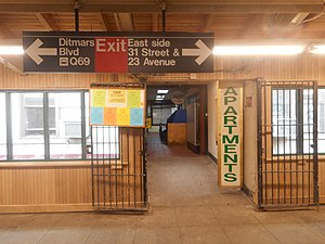
The station's only mezzanine is a station house beneath the tracks and platforms. Two double-wide staircases from the platform go down to their own bank of turnstiles with a token booth in the middle. Outside fare control, there are four staircases, two going down to the west side of 31st Street between Ditmars Boulevard and 23rd Avenue and two going down to the east side. The east side of the station house has a short, enclosed pedestrian bridge that leads to the Ditmars Plaza Mini Mall, located on the second floor of the adjacent Garry Building. This mall has a staircase to the street, providing another entrance to the station.[16]
Ridership[]
In 2019, the station had 5,277,341 boardings, making it the 120th most used station in the 424-station system. This amounted to an average of 17,912 passengers per weekday.[3]
Image gallery[]
Platform before 2019 renovation

Elisabeth Condon's Urban Idyll piece in the station's mezzanine.
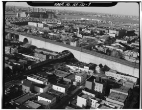
Station seen in 1970's
Gerry Building Entrance


References[]
- ^ "Glossary". Second Avenue Subway Supplemental Draft Environmental Impact Statement (SDEIS) (PDF). Vol. 1. Metropolitan Transportation Authority. March 4, 2003. pp. 1–2. Archived from the original (PDF) on February 26, 2021. Retrieved January 1, 2021.
- ^ "Station Developers' Information". Metropolitan Transportation Authority. Retrieved June 13, 2017.
- ^ a b "Facts and Figures: Annual Subway Ridership 2014–2019". Metropolitan Transportation Authority. 2020. Retrieved May 26, 2020.
- ^ "First Train Runs On Elevated Line to Astoria Section". Brooklyn Daily Eagle. February 1, 1917. Retrieved June 29, 2015 – via Newspapers.com.
- ^ a b Annual report. 1916-1917. New York: Interborough Rapid Transit Company. 1917.
- ^ a b c "First Train Runs On Elevated Line to Astoria Section". Brooklyn Daily Eagle. February 1, 1917. Retrieved June 29, 2015 – via Newspapers.com.

- ^ "Street Name Changes in Queens, New York". One-Step Webpages by Stephen P. Morse.
- ^ "Subway Link Over Queensboro Bridge". The New York Times. July 22, 1917. p. 31. Retrieved December 18, 2011.
- ^ "Additional Subway Service to Borough of Queens". The New York Times. April 8, 1923. p. RE1. Retrieved December 18, 2011.
- ^ "Direct Subway Runs to Flushing, Astoria". The New York Times. October 15, 1949. p. 17. Retrieved December 18, 2011.
- ^ Gargan, Edward A. (June 11, 1981). "Agency Lists its 69 Most Deteriorated Subway Stations". The New York Times. Retrieved August 13, 2016.
- ^ Barone, Vincent (February 8, 2018). "Queens residents, politicians are fed up with MTA construction". am New York. Retrieved February 10, 2018.
- ^ Martin, Douglas (November 17, 1996). "Subway Planners' Lofty Ambitions Are Buried as Dead-End Curiosities". The New York Times. Retrieved June 27, 2015.
- ^ Dougherty, Peter (2006) [2002]. Tracks of the New York City Subway 2006 (3rd ed.). Dougherty. OCLC 49777633 – via Google Books.
- ^ "Astoria Ditmars Blvd". MTA Arts & Design. MTA. 2018. Retrieved November 15, 2019.
- ^ "MTA Neighborhood Maps: Astoria" (PDF). Metropolitan Transportation Authority. 2015. Retrieved September 27, 2015.
External links[]
| Wikimedia Commons has media related to Astoria – Ditmars Boulevard (BMT Astoria Line). |
- nycsubway.org – BMT Astoria Line: Ditmars Boulevard
- Station Reporter — N Train
- TheSubwayNut - Astoria-Ditmars Boulevard
- Ditmars Boulevard entrance from Google Maps Street View
- Platform from Google Maps Street View
| Astoria Line | |
|---|---|
| |
- BMT Astoria Line stations
- New York City Subway stations in Queens, New York
- New York City Subway terminals
- New York City Subway stations located aboveground
- Railway stations in the United States opened in 1917
- Astoria, Queens
- 1917 establishments in New York City