South Ferry/Whitehall Street station
South Ferry/Whitehall Street | |||||||||||||
|---|---|---|---|---|---|---|---|---|---|---|---|---|---|
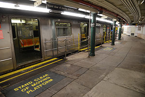
 The main entrance to the new South Ferry portion of the station in August 2013, before the restoration of the W train in 2016. | |||||||||||||
| Station statistics | |||||||||||||
| Address | South Street & Whitehall Street New York, NY 10004 | ||||||||||||
| Borough | Manhattan | ||||||||||||
| Locale | Battery Park and Financial District | ||||||||||||
| Coordinates | 40°42′09″N 74°00′46″W / 40.7025°N 74.0128°WCoordinates: 40°42′09″N 74°00′46″W / 40.7025°N 74.0128°W | ||||||||||||
| Division | A (IRT), B (BMT)[1] | ||||||||||||
| Line | BMT Broadway Line IRT Broadway–Seventh Avenue Line | ||||||||||||
| Services | 1 N R W | ||||||||||||
| Transit | MTA Bus: BM1, BM2, BM3, BM4, QM7, QM8, QM11, QM25 | ||||||||||||
| Other information | |||||||||||||
| Opened | March 16, 2009 | ||||||||||||
| Station code | 635[2] | ||||||||||||
| Accessible | |||||||||||||
| Traffic | |||||||||||||
| 2019 | 10,272,682[4] | ||||||||||||
| Rank | 27 out of 424[4] | ||||||||||||
| |||||||||||||
| |||||||||||||
| |||||||||||||


South Ferry/Whitehall Street is a New York City Subway station complex in the Manhattan neighborhood of Financial District, under Battery Park. The complex is shared by the IRT Broadway–Seventh Avenue Line and the BMT Broadway Line. It is served by the 1 and R trains at all times, the N train during late nights only, and the W train during weekdays only.
The complex originally consisted of three separate stations. In 1905, the Interborough Rapid Transit Company (IRT) opened a balloon loop at South Ferry, serving the IRT Broadway–Seventh Avenue and IRT Lexington Avenue Lines. The Brooklyn–Manhattan Transit Corporation (BMT) opened its station at Whitehall Street in 1918. The same year, the IRT opened a second loop for the IRT Lexington Avenue Line on the inside of the existing loop; the two loop stations were not connected to each other nor to the BMT station. Despite their proximity, the stations remained separate for 91 years.
In the early 2000s, as part of the recovery effort from the September 11, 2001, attacks, a new South Ferry terminal for the Broadway–Seventh Avenue Line was proposed. That station opened in 2009, replacing the loop station and providing a connection between the Broadway–Seventh Avenue Line's 1 train and the Broadway Line's N, R, and W trains. The new terminal for the Broadway–Seventh Avenue Line was severely damaged during Hurricane Sandy in 2012, and the MTA temporarily re-opened the loop station between 2013 and 2017, adding a temporary connection between the IRT Broadway–Seventh Avenue Line's loop and the BMT Broadway Line's platforms. The newer terminal reopened in June 2017 following extensive renovations and waterproofing work.
This station complex is the third on the site to bear the name South Ferry. The first was an elevated station located nearby, which was open from 1877 to 1950 and served the former IRT Ninth, Sixth, Third, and Second Avenue elevated lines. The second was the old South Ferry loop station, located above the existing station complex.
Station layout[]
| G | Street level | Exit/entrance Elevator at southwest corner of Whitehall and State Streets. Note: Elevator out of service |
| B1 South Ferry loops |
Side platform, not in service | |
| Separating wall | ||
| Inner loop | | |
| Outer loop | No regular service | |
| Side platform, not in service | ||
| Mezzanine | Fare control, station agent, MetroCard machines, passageway between platforms | |
| B2 | Landing | Broadway Line escalator landing |
| B3 Broadway platforms |
Northbound | ← ← ← |
| Island platform | ||
| Center track | ← ← | |
| Island platform | ||
| Southbound | | |
| B3 Broadway–Seventh Avenue platform | ||
| Track 4 | ← | |
| Island platform | ||
| Track 1 | ← | |
Exits[]

Entrances and exits are located at the following places:
- Two staircases at the west side of Whitehall and Stone Streets, east of the Alexander Hamilton U.S. Custom House (National Museum of the American Indian)[5]
- One staircase at the northeast corner of Whitehall and Stone Streets[5]
- Two staircases at the southwest corner of Whitehall and Water Streets[5]
 One set of staircase/escalators and one elevator northwest of the Whitehall Terminal[5]
- One set of staircase/escalator outside of the bus stop at the southeast corner of Water and State Streets[5]
- One staircase on the southwest side of State Street, south of the intersection with Pearl Street[5]
Lower Manhattan transit | ||||||||||||||||||||||||||||||||||||||||||||||||||||||||||||||||||||||||||||||||||||||||||||||||||
|---|---|---|---|---|---|---|---|---|---|---|---|---|---|---|---|---|---|---|---|---|---|---|---|---|---|---|---|---|---|---|---|---|---|---|---|---|---|---|---|---|---|---|---|---|---|---|---|---|---|---|---|---|---|---|---|---|---|---|---|---|---|---|---|---|---|---|---|---|---|---|---|---|---|---|---|---|---|---|---|---|---|---|---|---|---|---|---|---|---|---|---|---|---|---|---|---|---|---|
| ||||||||||||||||||||||||||||||||||||||||||||||||||||||||||||||||||||||||||||||||||||||||||||||||||
IRT Broadway–Seventh Avenue Line platforms[]
There are two separate stations on the IRT Broadway–Seventh Avenue Line, which are individually named South Ferry due to their connection to Manhattan's South Ferry. The name "South Ferry loops" is used for the Old South Ferry platforms, while the newer platforms are called "New South Ferry." The newer island platform station was first used by the Broadway–Seventh Avenue Line's 1 service from 2009[6] to 2012 until it was damaged by Hurricane Sandy,[7] and was again placed into use in 2017.[8][9][10] The outer loop platform was reopened on April 4, 2013, to provide temporary replacement service,[7][11][12] and closed again in 2017 when the newer station reopened.[8][9][10]
Old South Ferry station (1905–2009, 2013–2017)[]
South Ferry | |||||||||||||||||||||||||||||
|---|---|---|---|---|---|---|---|---|---|---|---|---|---|---|---|---|---|---|---|---|---|---|---|---|---|---|---|---|---|
| Former New York City Subway station | |||||||||||||||||||||||||||||
 Outer loop platform on reopening day (April 4, 2013) | |||||||||||||||||||||||||||||
| Station statistics | |||||||||||||||||||||||||||||
| Division | A (IRT)[13] | ||||||||||||||||||||||||||||
| Line | IRT Broadway–Seventh Avenue Line, IRT Lexington Avenue Line | ||||||||||||||||||||||||||||
| Services | None (abandoned) | ||||||||||||||||||||||||||||
| Structure | Underground | ||||||||||||||||||||||||||||
| Platforms | originally 2 side platforms, the inner platform is walled off | ||||||||||||||||||||||||||||
| Tracks | 2 balloon loops | ||||||||||||||||||||||||||||
| Other information | |||||||||||||||||||||||||||||
| Opened |
| ||||||||||||||||||||||||||||
| Closed |
| ||||||||||||||||||||||||||||
| Station code | 330[2] | ||||||||||||||||||||||||||||
| Station succession | |||||||||||||||||||||||||||||
| Next north | Rector Street: no regular service Bowling Green: no regular service | ||||||||||||||||||||||||||||
| Next south | (Terminal): no regular service | ||||||||||||||||||||||||||||
| |||||||||||||||||||||||||||||
Track layout | |||||||||||||||||||||||||||||||||||||||||||||||||||||||||||||||||||||||||||||||||||||||||||||||||||||||||||||||||||||||||||||||||||||||||||||||||||||||||||||||||||||||||||||||
|---|---|---|---|---|---|---|---|---|---|---|---|---|---|---|---|---|---|---|---|---|---|---|---|---|---|---|---|---|---|---|---|---|---|---|---|---|---|---|---|---|---|---|---|---|---|---|---|---|---|---|---|---|---|---|---|---|---|---|---|---|---|---|---|---|---|---|---|---|---|---|---|---|---|---|---|---|---|---|---|---|---|---|---|---|---|---|---|---|---|---|---|---|---|---|---|---|---|---|---|---|---|---|---|---|---|---|---|---|---|---|---|---|---|---|---|---|---|---|---|---|---|---|---|---|---|---|---|---|---|---|---|---|---|---|---|---|---|---|---|---|---|---|---|---|---|---|---|---|---|---|---|---|---|---|---|---|---|---|---|---|---|---|---|---|---|---|---|---|---|---|---|---|---|---|---|
| |||||||||||||||||||||||||||||||||||||||||||||||||||||||||||||||||||||||||||||||||||||||||||||||||||||||||||||||||||||||||||||||||||||||||||||||||||||||||||||||||||||||||||||||
| |||||||||||||||||||||||||||||||||||||||||||||||||||||||||||||||||||||||||||||||||||||||||||||||||||||||||||||||||||||||||||||||||||||||||||||||||||||||||||||||||||||||||||||||
The South Ferry loops consist of two side platforms on curved balloon loop tracks. The outer platform was operational until 2017, when it was permanently replaced by the new South Ferry station. The inner platform was in operation until 1977, and was subsequently walled off.[14] However, free transfers were unavailable between the platforms and each platform was meant to be served by its own line. The most recent configuration using both tracks consisted of the IRT Broadway–Seventh Avenue Line on the outer loop platform and the IRT Lexington Avenue Line on the inner loop platform.[15]
Outer platform[]
On July 10, 1905, the outer South Ferry platform was the first of the two platforms to open and was an extension of the original trunk line of the Interborough Rapid Transit Company.[16][17] The inner track existed when the station was built, but only as a storage track.[16] When the "H" system of the IRT opened on July 1, 1918, Broadway–Seventh Avenue Line trains used the outer platform while the inner platform was opened for IRT Lexington Avenue Line trains which used the original trunk line in Lower Manhattan.[18]
Only the end doors of each car of the five-car trains could platform at the station, because of the large gap between the middle doors and the platform, owing to the severe curve of the station. This problem was remedied in January 1959 when gap fillers were installed. In 1959, work was underway to construct a new station house.[19]
Services on the Broadway–Seventh Avenue Line, including the 1 and 9 trains (the latter of which was a rush-hour skip-stop duplicate of the former from 1989 to 2005), used the outer platform as a terminal station for more than a century since its inception, except for two relatively short periods of time. The first period was between September 2001 and September 2002 since the main branch south of Chambers Street was impassable after the September 11 attacks.[20]: 1-1 (PDF p. 1) The second was from March 16, 2009, when the new South Ferry station opened for 1 train passengers,[6] to April 4, 2013, when the outer platform reopened with a transfer to the BMT section of the station complex.[21][22] The newer station, located underneath this one, allowed a free transfer to the BMT station whereas neither of this station's platforms originally did.[6]
Station features[]

The platform was smaller than most others in the system, having only 16,800 square feet (1,560 m2) of surface area, and it was originally served from two stairs leading from the Staten Island Ferry's Whitehall Terminal.[20]: 1–7 (PDF p. 7) The radius of the curve is only 190 feet (58 m),[20]: 1–5 (PDF p. 5) [15] meaning that the platform curves approximately 77.5 degrees between its front and back ends.[a] The platform accommodated the first five cars of a train, but the rear five cars of a 10-car 1 train could not load or unload.[17][20]: 1–5 (PDF p. 5) [23] In addition, spray nozzles were required to lubricate the track to reduce the friction caused by the tight curve, which slowed train operation and generates a loud metallic scraping noise.[17][20]: 1–5 (PDF p. 5)
Because of the curve, gap fillers were required to bridge the gap between the platform and the doors.[17][20]: 1–5 (PDF p. 5) The gap fillers, which were automated when the station closed in 2017, previously required manual operation, with a foreman and at least two train crew, all of whom could directly see each other. The train crew had to give a signal to the foreman, who pulled a 4 to 5 feet (1.2 to 1.5 m) tall wooden lever to manually extend and retract the gap fillers.[15] The gap fillers were also unreliable, as they needed an average of 15 days of maintenance for every 6 months in service.[20]: 1–5 (PDF p. 5)
The platform featured an oak ticket booth and an oak-cased clock from the Self Winding Clock Company. Evidence of the now-demolished ticket booth is a Beaux Arts design engraved on the ceiling.[15] The platform also features station tiling by Heins & LaFarge, who designed the station plaque in a sans-serif font.[24] The walls are made of small white rectangular tiles, except for the bottom 3 feet (0.91 m), which is marble.[15] There are also fifteen ceramic plaques toward the top of the platform wall, all of which depict a sloop in the New York Harbor to signify the station's location and use. The top of the wall also includes festooned garlands and station monograms, in addition to ceramic trim where the wall intersects the ceiling. The station artwork on the original exit's landing is a 1990 mural, "South Sails", by former MTA Arts & Design director Sandra Bloodworth.[24][15] During the 2004 Finding Of No Significant Impact for the station, it was determined that the station was eligible for National Register of Historic Places status.[25]: 10 (PDF p. 11)
Replacement and restoration[]
The South Ferry loop station proved to be a service bottleneck. Operationally, the loop station functioned an intermediate station rather than as a true terminal, as trains would simply proceed back to Rector Street without the motorman needing to go to the reverse end of the train.[20]: 1-5 to 1-6 (PDF p. 5–6) Additionally, unlike most terminal stations in the system, there were neither layup tracks nor an additional track to store terminating trains, and there were no additional layup tracks along the line until at least 34th Street–Penn Station. This meant that trains could not dwell at the station for longer for 90 seconds (including the 5 to 10 seconds each that it took to extend and retract the gap fillers). Any trains that went out of passenger service at the station could have caused major delays along the rest of the line.[20]: 1–6 (PDF p. 6) Finally, trains could only proceed through the station at slow speeds, adding 30 to 60 seconds to travel time compared to a "regular" terminal station with two tracks and a full-length platform. This ensured that 1 trains were delayed at the Chambers Street station, three stops north, for up to two minutes in both directions.[20]: 1-6 to 1-7 (PDF p. 6–7)
To eliminate this special operation, the new station was built as a two-track, 10-car-long island platform on a less severe curve, permitting the operation of a typical terminal station.[17][26][23] The MTA stated that the new station saved four to six minutes of a passenger's trip time and increased the peak capacity of the 1 service to 24 trains per hour (or one every 2 minutes 30 seconds), as opposed to 16 to 17 trains per hour (or one every 4 minutes) with the loop station.[27][28] The successor station is fully accessible (although its transfer to the BMT Broadway Line is not), with the main entrance located across from the Staten Island Ferry terminal building's entrance.[20]: 1–9 (PDF p. 9) [26]
After Hurricane Sandy in late October 2012, the outer loop was brought back into service in order to turn trains uptown after terminating at Rector Street, as the replacement station suffered extensive flooding damage and closed for repairs. After a few months, the MTA decided to reopen the loop station as an interim terminal to restore the connection from 1 service to the Staten Island Ferry.[21][22] The South Ferry loop station was the first permanently-closed subway station to reopen since the founding of the MTA.[22] The station reopened on April 4, 2013, with a connection to the Broadway Line platforms,[7][11][12] and remained open until June 27, 2017.[8][9][10]
Inner platform[]
The inner platform opened for IRT Lexington Avenue Line passengers on July 1, 1918, to serve trains on the newly opened Broadway–Seventh Avenue Line.[18] This platform has an even sharper curve than the outer platform, and only the center doors opened here, with special arched openings in a wall between the platform and track at the locations of the doors.[15]
In the late 1950s, when the IRT division began to use mostly R-type cars which could not have only the center doors opened, 5 trains (which ended at South Ferry evenings and weekends only) and 6 trains (which ended at South Ferry late nights) were rerouted to the outer loop.[15] The Bowling Green–South Ferry shuttle, which ran weekdays and at first also late nights, continued to use the inner loop, running to the west platform at Bowling Green until 1977, when the inner platform was closed and Lexington Avenue trains stopped using the outer loop.[29] Specially modified R12 cars were used starting in the late 1960s until the service ended. These cars had two different door controls; the first opened the outer two sets of doors while the second opened the center set of doors only.[15][30] There was no free transfer between the inner loop and the outer loop platforms, which meant that passengers must pay another fare when moving from one loop to the other.[15]
No regular service has been at the inner loop station since February 13, 1977,[29] although the inner track is still used as a turning loop for 5 trains when they terminate at Bowling Green on weekday evenings and weekends.[15]
South Ferry station (2009–2012, 2017–present)[]
South Ferry | |||||||
|---|---|---|---|---|---|---|---|
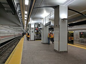 A 1 train at the platform on reopening day | |||||||
| Station statistics | |||||||
| Division | A (IRT)[31] | ||||||
| Line | IRT Broadway–Seventh Avenue Line | ||||||
| Services | 1 | ||||||
| Structure | Underground | ||||||
| Platforms | 1 island platform | ||||||
| Tracks | 2 | ||||||
| Other information | |||||||
| Opened | March 16, 2009 | ||||||
| Closed | October 28, 2012 | ||||||
| Rebuilt | June 27, 2017 | ||||||
| Accessible | |||||||
| Opposite- direction transfer | N/A | ||||||
| Station succession | |||||||
| Next north | Rector Street: 1 | ||||||
| Next south | (Terminal): 1 | ||||||
| |||||||
The South Ferry station, which serves the IRT Broadway–Seventh Avenue Line exclusively, has two tracks and one island platform and is the only IRT platform currently in use. The new station's platform has a slight curve, but unlike the loop stations, can fit all 10 cars of a full-length train without significant platform gaps or gap fillers. The two tracks end at bumper blocks at the south end of the platform.[32] This station was built as a replacement for the loop station, which was relegated to being used for turn-arounds once the new station opened. Unlike the loop station, this station is accessible only by IRT Broadway–Seventh Avenue Line local trains and does not connect with the Lexington Avenue Line.[17] It allows 24 trains per hour (or one every 2 minutes and 30 seconds) to terminate at the station.[27][28]
The new station offers three street entrances, with the main entrance located across from the Staten Island Ferry terminal;[5][20]: 1–9 (PDF p. 9) [26] the loop station originally had only one entrance within the terminal itself before it reopened with a connection to the South Ferry–Whitehall Street complex in 2013.[20]: 1–7 (PDF p. 7) It also added a free transfer to the Whitehall Street–South Ferry station on the BMT Broadway Line.[26] Landscaping for Peter Minuit Plaza, which is above the station, was completed in May 2010.[33]
Construction[]
On September 11, 2001, a terrorist attack destroyed the World Trade Center, located slightly to the north of South Ferry and the Battery. Since the entire WTC site was destroyed in the attacks, this meant that the segment of the IRT Broadway–Seventh Avenue Line that ran through the WTC, including the Cortlandt Street station two stops north of South Ferry, was also destroyed.[20]: 1-1 (PDF p. 1) This resulted in service changes to the 1, 2, and 3 routes and led to reduced service in Manhattan and Brooklyn until the WTC section of the line reopened in September 2002.[20]: 1–2 (PDF p. 2) Concurrent with the rebuilding of that section of the line, MTA officials recognized the need to build a more efficient terminal for the 1 and 9 trains at South Ferry, since it was anticipated that the line would be heavily used in the long-term aftermath of the attacks. This also coincided with the renovation of Battery Park.[20]: 1–2 (PDF p. 2) [23] The new station would also allow easier transfers for travelers to the Staten Island Ferry or the tour ferries to Liberty and Ellis islands.[23]
In 2003, money was allocated for the new station's construction,[34]: 69 and in 2005, construction commenced on the new station.[35] The station was originally budgeted at $400 million, with most of the money being a grant from the Federal Transit Administration earmarked for World Trade Center reconstruction.[17] Initially, the station's construction had been opposed because of the high cost and low perceived time savings.[36] Community leaders acquiesced after being told that some of the money was going to be used to renovate Battery Park,[37] and the South Ferry Terminal Project was allowed to proceed.[38]: slide 2 (p. 1)
The FTA issued a Finding of No Significant Impact on August 30, 2004.[25]: PDF p. 1 During planning, the FTA evaluated several alternatives, including extending the existing loop platform northward; building the terminal with an extra track and platform; building a two-track terminal underneath the loop; building a two-track terminal directly under Water Street, to the east; building a two-track terminal along the waterfront under South Street, to the southeast; building a three-track terminal below the BMT Broadway Line's Whitehall Street station, under the namesake street; and building the terminal diagonally under Peter Minuit Plaza. Of these seven options, the last one was chosen because any other alternative would have been either too expensive or logistically infeasible.[25]: 3–4 (PDF p. 4–5)
The project was split up into three parts: construction of bellmouths, a fan plant, and track junctions from the existing line; approach tunnels to the station; and the station itself.[20]: 1–8 (PDF p. 8) The bellmouths' construction would require that 270 feet (82 m) of the original tunnel would have to be rebuilt to accommodate the new junction. The fan plant, located to the east of the existing line, would facilitate ventilation from the new deep-level station, which would be located below three exiting subway lines (the loop platform, the IRT Lexington Avenue Line's Joralemon Street Tunnel, and the BMT Broadway Line's Montague Street Tunnel).[20]: 1-8 to 1-9 (PDF p. 8–9) The two new approach tunnels would be single-track tunnels connecting to a cavern where a double crossover switch would be installed.[20]: 1–9 (PDF p. 9) The new 76,820-square-foot (7,137 m2) station, located at a depth of 50 feet (15 m), would contain a 600-by-25-foot (182.9 by 7.6 m) platform, a new mezzanine level, escalators, and an elevator.[20]: 1-9 to 1-10 (PDF p. 9–10)
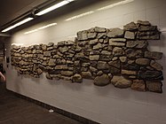
In late 2005, New York City authorities announced that builders working on the new station had found the remains of a stone wall from the British colonial era, during the late 17th or 18th centuries.[39] After archaeological analysis, it was widely reported to be the oldest man-made structure still in place in Manhattan. Four walls and over 250,000 individual artifacts were found in the excavation of the subway station. A portion of one wall was placed on temporary display inside Castle Clinton.[40]
In December 2008, news sources reported that the new station was essentially finished.[17][41] However, the following month, the opening was delayed because the tracks were too far from the edge of the platform, and the gap between the platform and the train did not meet ADA standards.[42] Other delays were attributed to leaks in the station,[43] which were caused by the station's high water table.[28] The problem was corrected and the station opened on March 16, 2009,[44][42][28][45] a year behind when it was originally set to open.[46] At $530 million, the new South Ferry station ended up being $130 million over budget.[17] It was the first new subway station completed since 1989 when the IND 63rd Street Line stations opened.[28][b] On April 16, 2009, MTA Capital Construction awarded a $19.2 million contract to Tully Construction Company to reconstruct Peter Minuit Plaza.[48]
After the station opened, a long portion of the excavated historic wall was embedded permanently into the wall of the entrance to the newly constructed station. "This wall most likely is a portion of the gun batteries that once protected the city in the late 17th and 18th centuries and gave rise to the modern park name," said Robert Tierney, chairman of the New York City Landmarks Preservation Commission. The city and the New York City Transit Authority plan to work together to preserve the remains, which were described as "an important remnant of the history of New York City."[40]
The station's mezzanine and escalator shafts feature monumental artwork titled See it split, see it change, which consists of fused glass wall, stone mosaic, and a stainless steel fence.[49] The artwork, by Doug and Mike Starn, depicts Manhattan topography and was installed in the mezzanine over a period of three years.[50][51] At the time of the work's installation, it was the most expensive MTA Arts for Transit work ever installed, with a price tag of $1 million.[51]
Post–Hurricane Sandy[]

On October 29, 2012, the new South Ferry station suffered extensive flooding damage caused by Hurricane Sandy.[7] The station was flooded in up to 80 feet (24 m) of salt water,[52] submerging it from the track level to the mezzanine, and turned the station into a "large fish tank," as then-MTA chairman Joseph Lhota described it.[53] As a result, this section of the complex was closed until further notice. The MTA estimated that repairs would cost $600 million and might continue until 2016.[53][54] The terminal for the routes serving the station was moved back to Rector Street until the old loop station could be put back into service. The old loop station reopened on April 4, 2013, as a temporary replacement until the new station could be restored to revenue service.[21][22][11] The connection between the loop station and the rest of the station necessitated the temporary removal of a 20-foot (6.1 m) section of the See it split, see it change artwork.[55]
The station underwent renovations, signal room relocations, and extensive waterproofing work.[56][52][57] The $194 million contract was awarded in November 2014 to ,[58]: 39 and the station underwent extensive reconstruction until its reopening. Some undertaken tasks included the installation of retractable floodgates at exits and entrances, the sealing of vents, manholes, hatches, conduits, and ducts, and the cleaning up of the station.[58]: 39 [52] These improvements necessitated the closure of the station complex's main entrance for almost a year starting in October 2015.[59][60]
The renovation cost $345 million.[58]: 39 [56] The station reopened on June 27, 2017, four years and eight months after Hurricane Sandy. The opening occurred in time to accommodate new service patterns due to a long-term weekend closure of the Clark Street Tunnel, which diverted weekend 2 trains to South Ferry for one year.[8][9][10][61]
Gallery[]
- Old station
Movable gap filler at station
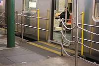
Conductor controls the whole length of the curved platform using monitors

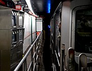
Passageway to BMT platforms as seen from end of loop platform


- Old station's mosaics

Mosaic tile name tablet

Artwork on the left

One of the many boat mosaics within the station


- New station

New artwork
Excavated wall

Flooded station after Hurricane Sandy


BMT Broadway Line platforms[]
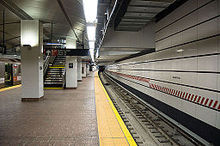
Whitehall Street–South Ferry | |||||||||||||||||||||||||||||||||||||||||||||||||||||||||||||||||||||||||||||||||||||||||||||||||||||||||
|---|---|---|---|---|---|---|---|---|---|---|---|---|---|---|---|---|---|---|---|---|---|---|---|---|---|---|---|---|---|---|---|---|---|---|---|---|---|---|---|---|---|---|---|---|---|---|---|---|---|---|---|---|---|---|---|---|---|---|---|---|---|---|---|---|---|---|---|---|---|---|---|---|---|---|---|---|---|---|---|---|---|---|---|---|---|---|---|---|---|---|---|---|---|---|---|---|---|---|---|---|---|---|---|---|---|
 Middle track with W train departing | |||||||||||||||||||||||||||||||||||||||||||||||||||||||||||||||||||||||||||||||||||||||||||||||||||||||||
| Station statistics | |||||||||||||||||||||||||||||||||||||||||||||||||||||||||||||||||||||||||||||||||||||||||||||||||||||||||
| Division | B (BMT)[62] | ||||||||||||||||||||||||||||||||||||||||||||||||||||||||||||||||||||||||||||||||||||||||||||||||||||||||
| Line | BMT Broadway Line | ||||||||||||||||||||||||||||||||||||||||||||||||||||||||||||||||||||||||||||||||||||||||||||||||||||||||
| Services | N R W | ||||||||||||||||||||||||||||||||||||||||||||||||||||||||||||||||||||||||||||||||||||||||||||||||||||||||
| Structure | Underground | ||||||||||||||||||||||||||||||||||||||||||||||||||||||||||||||||||||||||||||||||||||||||||||||||||||||||
| Platforms | 2 island platforms cross-platform interchange | ||||||||||||||||||||||||||||||||||||||||||||||||||||||||||||||||||||||||||||||||||||||||||||||||||||||||
| Tracks | 3 | ||||||||||||||||||||||||||||||||||||||||||||||||||||||||||||||||||||||||||||||||||||||||||||||||||||||||
| Other information | |||||||||||||||||||||||||||||||||||||||||||||||||||||||||||||||||||||||||||||||||||||||||||||||||||||||||
| Opened | September 20, 1918 | ||||||||||||||||||||||||||||||||||||||||||||||||||||||||||||||||||||||||||||||||||||||||||||||||||||||||
| Station code | 023[2] | ||||||||||||||||||||||||||||||||||||||||||||||||||||||||||||||||||||||||||||||||||||||||||||||||||||||||
| Accessible | |||||||||||||||||||||||||||||||||||||||||||||||||||||||||||||||||||||||||||||||||||||||||||||||||||||||||
| Opposite- direction transfer | Yes | ||||||||||||||||||||||||||||||||||||||||||||||||||||||||||||||||||||||||||||||||||||||||||||||||||||||||
| Former/other names | Whitehall Street | ||||||||||||||||||||||||||||||||||||||||||||||||||||||||||||||||||||||||||||||||||||||||||||||||||||||||
| Station succession | |||||||||||||||||||||||||||||||||||||||||||||||||||||||||||||||||||||||||||||||||||||||||||||||||||||||||
| Next north | Rector Street: N (Terminal): R | ||||||||||||||||||||||||||||||||||||||||||||||||||||||||||||||||||||||||||||||||||||||||||||||||||||||||
| Next south | (Terminal): W Court Street: N | ||||||||||||||||||||||||||||||||||||||||||||||||||||||||||||||||||||||||||||||||||||||||||||||||||||||||
| |||||||||||||||||||||||||||||||||||||||||||||||||||||||||||||||||||||||||||||||||||||||||||||||||||||||||
| |||||||||||||||||||||||||||||||||||||||||||||||||||||||||||||||||||||||||||||||||||||||||||||||||||||||||
Whitehall Street–South Ferry[63] on the BMT Broadway Line has three tracks and two island platforms. The outer tracks continue south into the Montague Street Tunnel to the BMT Fourth Avenue Line in Brooklyn, and are used by late-night N trains and daytime R trains. The center track, used to terminate late-night R trains from Brooklyn[64] and weekday W trains from Queens,[65] merges with the outer tracks at both ends of the station.
The station is deep because of two factors: the line goes under the East River directly southeast of the station, and the station exists immediately to the south of the shallower Bowling Green station, which crosses the Broadway Line. The fare control area and transfer to the IRT Broadway–Seventh Avenue Line platforms are at the extreme south end of the station, with additional exits at the north end.[5][66]
South of this station, a pair of bellmouths exists, allowing for a connection to a never-built East River tunnel south of the Montague Street Tunnel, going towards the proposed DeKalb Avenue bypass, using the old LIRR Atlantic Avenue Tunnel or under another street in Brooklyn. Further south is a flying junction joining from Broad Street on the BMT Nassau Street Line (no regular service).[14]
When this station opened on September 20, 1918, it was the terminal for the Broadway Line.[67][68] An additional entrance at the southern end of the station opened in November 1919, providing a direct connection to the Whitehall Terminal of the Staten Island Ferry.[69] The extension to Brooklyn opened on August 1, 1920.[70]
On January 6, 1994, Automated Fare Collection turnstiles went into service at this station and at the Wall Street station.[71]
Notable places nearby[]
- Downtown Manhattan Heliport[5]
- Staten Island Ferry's Whitehall Terminal[5]
- Ferries to Statue of Liberty, Ellis Island, and Governors Island[5]
- Other places in the neighborhood[5]
Notes[]
- ^ The 190-foot (58 m) radius indicates that a full circle of that radius would have a circumference of 1193.805 feet. A typical five-car IRT train is about 257 feet (78 m) long, as opposed to a ten-car train that is 514 feet (157 m) long. The proportion of the train's length to the full circle indicates that the arc is 77.5 degrees.
- ^ However, the South Ferry station did not qualify as a completely new subway station, as it was connected to a pre-existing station. On the other hand, the 34th Street–Hudson Yards station, which opened in 2015, is the first completely new subway station since 1989, since it is standalone and does not connect to any pre-existing stations.[47]
References[]
- ^ "Glossary". Second Avenue Subway Supplemental Draft Environmental Impact Statement (SDEIS) (PDF). 1. Metropolitan Transportation Authority. March 4, 2003. pp. 1–2. Archived from the original (PDF) on February 26, 2021. Retrieved January 1, 2021.
- ^ a b c "Station Developers' Information". Metropolitan Transportation Authority. Retrieved June 13, 2017.
- ^ "Facts and Figures: Annual Subway Ridership 2014–2019". Metropolitan Transportation Authority. 2020. Retrieved May 26, 2020.
- ^ a b "Facts and Figures: Annual Subway Ridership 2014–2019". Metropolitan Transportation Authority. 2020. Retrieved May 26, 2020.
- ^ a b c d e f g h i j k l "MTA Neighborhood Maps: Lower Manhattan" (PDF). mta.info. Metropolitan Transportation Authority. 2016. Retrieved June 27, 2016.
- ^ a b c "MTA Opens New South Ferry Subway Terminal" (Press release). Metropolitan Transportation Authority. March 16, 2009. Retrieved June 7, 2009.
- ^ a b c d Donohue, Pete (April 4, 2013). "South Ferry subway station reopens to public after Sandy damage". NY Daily News. Retrieved December 17, 2016.
- ^ a b c d "South Ferry subway station in Manhattan reopens". ABC 7 New York. June 27, 2017. Retrieved June 27, 2017.
- ^ a b c d Danielle Furfaro (June 27, 2017). "South Ferry station finally reopening nearly 5 years after Sandy". New York Post.
- ^ a b c d Warerkar, Tanay (June 26, 2017). "South Ferry subway station readies for its reopening after Sandy". Curbed NY. Retrieved June 27, 2017.
- ^ a b c Mann, Ted (April 4, 2013). "With Old South Ferry Reopening, a Connection Restored". WSJ. Retrieved February 24, 2018.
- ^ a b Flegenheimer, Matt (April 3, 2013). "Subway Service Is Returning to Old South Ferry Station". City Room. Retrieved February 24, 2018.
- ^ "Glossary". Second Avenue Subway Supplemental Draft Environmental Impact Statement (SDEIS) (PDF). 1. Metropolitan Transportation Authority. March 4, 2003. pp. 1–2. Archived from the original (PDF) on February 26, 2021. Retrieved January 1, 2021.
- ^ a b Dougherty, Peter (2020). Tracks of the New York City Subway 2020 (16th ed.). Dougherty. OCLC 1056711733.
- ^ a b c d e f g h i j k Kevin Walsh (December 2008). "Last Days at South Ferry". Forgotten NY. Retrieved July 7, 2015.
- ^ a b "Subway Trains Running From Bronx to Battery — West Farms and South Ferry Stations Open at Midnight — Start Without a Hitch — Bowling Green Station Also Opened — Lenox Avenue Locals Take City Hall Loop Hereafter". New York Times. July 10, 1905. p. 1. Retrieved November 6, 2016.
- ^ a b c d e f g h i Neuman, William (December 11, 2008). "At the Last Subway Stop, a New Exit Strategy". The New York Times. ISSN 0362-4331. Retrieved June 7, 2009.
- ^ a b "Open Clark Street Line — New Route Doubles Subway Service Between the Two Boroughs" (PDF). The New York Times. April 16, 1919. p. 18. Retrieved November 6, 2016.
- ^ "Annual Report For The Year Ended June 30, 1959" (PDF). nycsubway.org. New York City Transit Authority. October 1959. pp. 9–10. Retrieved December 21, 2020.
- ^ a b c d e f g h i j k l m n o p q r s t "Environmental Assessment and Section 4(f) Evaluation, Section 1.0: Purpose and Need and Description for the Proposed Action" (PDF). mta.info. Metropolitan Transportation Authority. May 2004. Retrieved December 17, 2016.
- ^ a b c "Old South Ferry Station to Reopen for Service in early April" (Press release). Metropolitan Transportation Authority. March 8, 2013. Retrieved May 5, 2016.
- ^ a b c d Flegenheimer, Matt (March 8, 2013). "Storm Damage Prompts Return of Old Subway Stop". The New York Times. Retrieved July 23, 2016.
- ^ a b c d Connolly, Michael (July 5, 2006). "New York Subway Stop to Be More User-Friendly; Building a Bigger Station At South Ferry Should Keep Riders From Getting Stuck". Wall Street Journal. p. A.18. ISSN 0099-9660. ProQuest 398958828.
- ^ a b Lower Manhattan Development Corporation (2007). East River Waterfront Esplanade and Piers: Environmental Impact Statement. p. 6.19. Retrieved February 19, 2018.
- ^ a b c "Finding of No Significant Impact: South Ferry Terminal Project" (PDF). mta.info. Federal Transit Administration. August 30, 2004. Retrieved December 18, 2016.
- ^ a b c d Yates, Maura (December 12, 2008). "New subway station has plenty of upside". Staten Island Advance. Archived from the original on August 10, 2009. Retrieved June 7, 2009.
- ^ a b Cuza, Bobby (December 11, 2008). "Brand-New South Ferry Station To Open Soon". NY1. Archived from the original on August 10, 2009. Retrieved June 7, 2009.
- ^ a b c d e "South Ferry station opening to Staten Island commuters". SILive.com. March 16, 2009. Retrieved December 17, 2016.
- ^ a b "M.T.A. Expected to Save Franklin Avenue Shuttle, Once an Austerity Target". The New York Times. February 10, 1977. p. 27. Retrieved July 18, 2010.
- ^ Cunningham, Joseph; DeHart, Leonard O. (January 1, 1993). A History of the New York City Subway System. J. Schmidt, R. Giglio, and K. Lang.
- ^ "Glossary". Second Avenue Subway Supplemental Draft Environmental Impact Statement (SDEIS) (PDF). 1. Metropolitan Transportation Authority. March 4, 2003. pp. 1–2. Archived from the original (PDF) on February 26, 2021. Retrieved January 1, 2021.
- ^ "More Room at the End of the Line". The New York Times. December 12, 2008. ISSN 0362-4331. Retrieved December 17, 2016.
- ^ "South Ferry Terminal Project". mta.info. Metropolitan Transportation Authority. Retrieved October 31, 2015.
- ^ "September 11: Overview of Federal Disaster Assistance to the New York City Area" (PDF). gao.gov. United States General Accounting Office. October 2003. Retrieved December 16, 2016.
- ^ "About FTA". FTA. December 3, 2003. Archived from the original on September 6, 2015. Retrieved October 31, 2015.
- ^ Young, Dana (September 22, 2005). "Opposition to South Ferry subway project grows". Downtown Express. Archived from the original on March 4, 2016. Retrieved October 31, 2015.
- ^ Hu, Winnie (June 19, 2004). "Battery Park Given Slice of Pie In South Ferry Subway Project". The New York Times. ISSN 0362-4331. Retrieved September 20, 2017.
- ^ "South Ferry Terminal Update for Community Board 1" (PDF). mta.info. Metropolitan Transportation Authority. February 10, 2005. Retrieved December 17, 2016.
- ^ McGeehan, Patrick (December 8, 2005). "Found: Old Wall in New York, and It's Blocking the Subway". The New York Times. ISSN 0362-4331. Retrieved May 14, 2019.
- ^ a b Haddon, Heather (February 24, 2010). "Unearthing colonial New York: South Ferry project yields 65K artifacts". Newsday. Retrieved February 18, 2018.
- ^ Donohue, Pete (December 12, 2008). "New South Ferry station to open in January". NY Daily News. Retrieved December 17, 2016.
- ^ a b New and Old Downtown: Wall Street and South Ferry. Forgotten NY. Retrieved June 11, 2014.
- ^ "Staten Island commuters counting down days until new subway station opens". SILive.com. March 11, 2009. Retrieved October 31, 2015.
- ^ "MTA Opens New South Ferry Subway Terminal". mta.info. Metropolitan Transportation Authority. March 16, 2009. Retrieved December 18, 2016.
- ^ Donohue, Pete (March 17, 2009). "MTA opens new $530M South Ferry station". New York Daily News. Retrieved July 21, 2016.
- ^ Neuman, William (March 17, 2009). "New Station at South Ferry Opens, but a Main Breaks Upstream". The New York Times. ISSN 0362-4331. Retrieved December 17, 2016.
- ^ Fitzsimmons, Emma G. (September 12, 2015). "Subway Station to Open This Weekend, Bringing 7 Line to Far West Side". The New York Times. Retrieved September 13, 2015.
- ^ "MTA Capital Construction – Procurement". web.mta.info. Retrieved October 23, 2016.
- ^ "MTA – Arts & Design | NYCT Permanent Art". web.mta.info. Retrieved July 23, 2016.
- ^ "New subway station has plenty of upside". www.silive.com. Archived from the original on August 10, 2009. Retrieved July 23, 2016.
- ^ a b Ryzik, Melena (December 14, 2008). "Mike and Doug Starn's Installation at the New South Ferry Subway Station". The New York Times. ISSN 0362-4331. Retrieved December 17, 2016.
- ^ a b c Donohue, Peter (December 8, 2014). "$194 million contract awarded to upgrade South Ferry subway station". Daily News. NYDailyNews.com. Retrieved February 7, 2015.
- ^ a b "Flood, Rebuild, Repeat: Are We Ready for a Superstorm Sandy Every Other Year?". Mother Jones. July–August 2013.
- ^ "mta.info | Restoring South Ferry Station". web.mta.info. Retrieved December 17, 2016.
- ^ "mta.info | Superstorm Sandy: One Year Later". web.mta.info. Retrieved July 24, 2016.
- ^ a b "mta.info | Superstorm Sandy: One Year Later". web.mta.info. Metropolitan Transportation Authority. Archived from the original on August 3, 2016. Retrieved July 23, 2016.
- ^ Furfaro, Danielle (October 29, 2016). "Sandy-ravaged subway entrance to be closed 9 months". New York Post. Retrieved October 31, 2015.
- ^ a b c "Capital Program Oversight Committee Meeting" (PDF). mta.info. Metropolitan Transportation Authority. July 2017. Retrieved September 15, 2017.
- ^ Rivoli, Dan (October 29, 2016). "South Ferry station entrance to close for more than 9 months". NY Daily News. Retrieved October 31, 2015.
- ^ "South Ferry Station on Track to Reopen this Summer after Hurricane Sandy Repairs". TWC News. Retrieved January 22, 2017.
- ^ "Clark St Tunnel Reconstruction Weekend Service Changes". web.mta.info. Metropolitan Transportation Authority. June 8, 2017. Retrieved June 8, 2017.
- ^ "Glossary". Second Avenue Subway Supplemental Draft Environmental Impact Statement (SDEIS) (PDF). 1. Metropolitan Transportation Authority. March 4, 2003. pp. 1–2. Archived from the original (PDF) on February 26, 2021. Retrieved January 1, 2021.
- ^ "Subway Map" (PDF). Metropolitan Transportation Authority. September 2021. Retrieved September 17, 2021.
- ^ "R Subway Timetable, Effective November 8, 2020" (PDF). Metropolitan Transportation Authority. Retrieved December 9, 2020.
- ^ "W Subway Timetable, Effective November 8, 2020" (PDF). Metropolitan Transportation Authority. Retrieved December 9, 2020.
- ^ "Figure 5: South Ferry Terminal Project Conceptual Site Plan" (PDF). mta.info. Metropolitan Transportation Authority. Retrieved December 17, 2016.
- ^ District, New York (State) Public Service Commission First (January 1, 1919). Report of the Public Service Commission for the First District of the State of New York. J.B. Lyon Company.
- ^ Legislative Documents. J.B. Lyon Company. 1920 – via Google Books.
- ^ "Open Subway Entrance; Whitehall Street Station Connected with Ferryhouses" (PDF). The New York Times. November 16, 1919. p. 36. ISSN 0362-4331. Retrieved February 24, 2021.
- ^ "New B.R.T. Lines Open – Broadway-Brighton Trains, on Holiday Schedule, Have Light Traffic" (PDF). The New York Times. August 2, 1920. Retrieved November 5, 2016.
- ^ "About NYC Transit – History". mta.info. Metropolitan Transportation Authority. October 18, 2002. Archived from the original on October 19, 2002. Retrieved September 18, 2016.CS1 maint: bot: original URL status unknown (link)
Further reading[]
- Stookey, Lee (1994). Subway ceramics : a history and iconography of mosaic and bas relief signs and plaques in the New York City subway system. Brattleboro, Vt: L. Stookey. ISBN 978-0-9635486-1-0. OCLC 31901471.
External links[]
| Wikimedia Commons has media related to South Ferry – Whitehall Street (New York City Subway). |
- South Ferry Terminal Project — Official MTA South Ferry Station Project Page
- Accessible New York City Subway stations
- 1905 establishments in New York (state)
- 1918 establishments in New York (state)
- 1977 disestablishments in New York (state)
- 2009 disestablishments in New York (state)
- 2013 establishments in New York City
- Battery Park City
- BMT Broadway Line stations
- Defunct Interborough Rapid Transit Company stations
- IRT Broadway–Seventh Avenue Line stations
- IRT Lexington Avenue Line stations
- New York City Subway stations in Manhattan
- New York City Subway terminals
- New York City Subway stations located underground
- New York City Subway transfer stations
- Railway stations closed in 1977
- Railway stations closed in 2009
- Railway stations in the United States opened in 1905
- Railway stations in the United States opened in 2013
- Railway stations in the United States opened in 1918
- South Ferry, Manhattan
- Staten Island Ferry
- Transportation buildings and structures in Manhattan