36th Street station (BMT Fourth Avenue Line)
36 Street | |||
|---|---|---|---|
 Uptown platform | |||
| Station statistics | |||
| Address | 36th Street & Fourth Avenue Brooklyn, NY 11232[1] | ||
| Borough | Brooklyn | ||
| Locale | Sunset Park | ||
| Coordinates | 40°39′15″N 74°00′16″W / 40.65417°N 74.00444°WCoordinates: 40°39′15″N 74°00′16″W / 40.65417°N 74.00444°W | ||
| Division | B (BMT)[2] | ||
| Line | BMT Fourth Avenue Line | ||
| Services | D N Q R W | ||
| Transit | |||
| Structure | Underground | ||
| Platforms | 2 island platforms cross-platform interchange | ||
| Tracks | 4 | ||
| Other information | |||
| Opened | June 22, 1915 | ||
| Station code | 032[4] | ||
| Accessible | not ADA-accessible; accessibility planned | ||
| Accessibility | Cross-platform wheelchair transfer available | ||
| Opposite- direction transfer | Yes | ||
| Traffic | |||
| 2019 | 4,254,406[5] | ||
| Rank | 116 out of 424[5] | ||
| Station succession | |||
| Next north | Atlantic Avenue–Barclays Center (express): D 25th Street (local): D | ||
| Next south | Ninth Avenue (West End): D 45th Street (local): N 59th Street (express): N | ||
| |||
| |||
| |||
| |||


36th Street is an express station on the BMT Fourth Avenue Line of the New York City Subway, located at 36th Street and Fourth Avenue in Sunset Park, Brooklyn. It is served by the D, N and R trains at all times.[6] During rush hours, several W and northbound Q trains also serve the station.[a]
The 36th Street station was constructed as part of the Fourth Avenue Line, which was approved in 1905. Construction on the segment of the line that includes 36th Street started on December 10, 1909, and was completed in October 1912. The station opened on June 22, 1915, as part of the initial portion of the BMT Fourth Avenue Line to 59th Street.
History[]
Construction[]
The 36th Street station was constructed as part of the Fourth Avenue Line, the plan for which was initially adopted on June 1, 1905.[8] The Rapid Transit Commission was succeeded on July 1, 1907, by the New York State Public Service Commission (PSC), which approved the plan for the line in late 1907.[9][10] The contract for the section of the line that included the 36th Street station, Route 11A4, which extended from 27th Street to 43rd Street, was awarded on May 22, 1908, to the E.E. Smith Construction Company for $2,769.913.97 (equivalent to $79,784,000 in 2020). The New York City Board of Estimate approved the contract on October 29, 1909.[9][11] Construction on the segment started on December 10, 1909, and was completed in October 1912.[8]
As part of negotiations between New York City, the Brooklyn Rapid Transit Company (BRT), and the Interborough Rapid Transit Company for the expansion of the city's transit network, the line was leased to a subsidiary of the BRT. The agreement, known as Contract 4 of the Dual Contracts, was signed on March 19, 1913.[9] 36th Street opened on June 22, 1915, as part of an extension of the subway to Coney Island, which included the Fourth Avenue Line north of 59th Street as well as the entire Sea Beach Line.[12][13] The station's opening was marked with a competition between two trains heading from Chambers Street station in Manhattan to the Coney Island station, one heading via the West End Line and the other via the Sea Beach Line; the latter got to Coney Island first.[13] As part of the Dual Contracts, the original southern half of the station was closed to make room for an above-ground connection to the BMT West End Line, and a new northern half was constructed.[14]
Renovations[]
In July 1959, the New York City Transit Authority (NYCTA) announced that it would install fluorescent lighting at the 36th Street station and five other stations along the Fourth Avenue Line for between $175,000 and $200,000. Bids on the project were to be advertised on August 7, 1959 and completed by fall 1960.[15]
In the 1960s, the New York City Transit Authority (NYCTA) started a project to lengthen station platforms on its lines in Southern Brooklyn to 615 feet (187 m) to accommodate 10-car trains.[16] On July 14, 1967, the NYCTA awarded a contract to conduct test borings at eleven stations on the Fourth Avenue Line, including 36th Street, to the W. M. Walsh Corporation for $6,585 (equivalent to $51,109 in 2020) in preparation of the construction of platform extensions.[17] The NYCTA issued an invitation for bids on the project to extend the platforms at stations along the Fourth Avenue Line between Pacific Street and 36th Street, on March 28, 1969.[18] Funding for the renovation projects came out of the NYCTA's 1969–1970 Capital Budget, costing $8,177,890 (equivalent to $57,713,000 in 2020) in total.[19]
The station was overhauled from 1996 to 1997.[20] The changes included retiled walls,[21] rebuilt staircases, new tiling on the floors, upgrading the station's lights, installing ADA yellow safety treads along the platform edge, and new track-beds for local and express trains.[citation needed] It also included an art installation by Owen Smith called An Underground Movement: Designers, Builders, Riders. It features ceramic mosaics on mezzanine and stairway walls, and depicts the workers that have made the subway system possible.[22]
In May 2018, New York City Transit Authority President Andy Byford announced his plan subway and bus modernization plan, known as Fast Forward, which included making an additional 50 stations compliant with the Americans with Disabilities Act of 1990 during the 2020–2024 Metropolitan Transportation Authority (MTA) Capital Program to allow most riders to have an accessible station every two or three stops.[23][24] The draft 2020–2024 Capital Program released in September 2019, included 66 stations that would receive ADA improvements, including 36th Street.[25][26][27]
Station layout[]
| G | Street level | Exit/entrance |
| M | Mezzanine | Fare control, station agent |
| P Platform level |
Northbound local | ← ← ← ← |
| Island platform | ||
| Northbound express | ← ← ← | |
| Southbound express | | |
| Island platform | ||
| Southbound local | | |

36th Street is an express station with four tracks and two island platforms. R and W trains provide local service, while D and N trains run express (except during nights when they also run local). South of here, N, R, and W trains continue on Fourth Avenue, while D trains diverge east onto the BMT West End Line.[14] This is one of two "36th Street" stations served by the R train; the other is 36th Street on the IND Queens Boulevard Line.[28]
The station originally featured two mezzanines. The mezzanine in what is now the southern half of the station was originally the northern one. A second southern mezzanine was isolated and closed off when the original southern half of the station was closed to make way for the West End Line. However, it is still intact; it was converted to a signal relay room and can be reached by an intact stairway in the tunnel.[29]
Exits[]
The station's only two exits are from the open northern mezzanine above the tracks at the very south end of the station. Outside fare control, two street stairs lead to the northwest corner of 4th Avenue and 36th Street. Another street stair leads to the northeast corner.[30]
Proposed subway under 40th Street[]
There are three abandoned trackways south of 36th Street station. One trackway merges with the southbound local track, and the other two trackways are south of the tracks that ramp up to the BMT West End Line. The triple trackway ramps down to a lower level, under the mainline tracks, and curves slightly east before ending. On the main track level, a bellmouth going east is visible from a Manhattan-bound local train,[31] just south of this station. When the subway was planned as part of the Triborough System, use of the South Brooklyn cut was not anticipated, and instead a four-track subway was to be built in 40th Street to reach the equivalent of the Culver and West End lines. The unused junction is to the east side of Fourth Avenue.[14]
Nearby points of interest[]
Notes[]
References[]
- ^ "Borough of Brooklyn, New York City". Government of New York City. Retrieved April 16, 2020.
- ^ "Glossary". Second Avenue Subway Supplemental Draft Environmental Impact Statement (SDEIS) (PDF). 1. Metropolitan Transportation Authority. March 4, 2003. pp. 1–2. Archived from the original (PDF) on February 26, 2021. Retrieved January 1, 2021.
- ^ "Brooklyn Bus Map" (PDF). Metropolitan Transportation Authority. October 2020. Retrieved December 1, 2020.
- ^ "Station Developers' Information". Metropolitan Transportation Authority. Retrieved June 13, 2017.
- ^ "Facts and Figures: Annual Subway Ridership 2014–2019". Metropolitan Transportation Authority. 2020. Retrieved May 26, 2020.
- ^ *"D Subway Timetable, Effective November 8, 2020" (PDF). Metropolitan Transportation Authority. Retrieved December 9, 2020.
- "N Subway Timetable, Effective November 8, 2020" (PDF). Metropolitan Transportation Authority. Retrieved December 9, 2020.
- "R Subway Timetable, Effective November 8, 2020" (PDF). Metropolitan Transportation Authority. Retrieved December 9, 2020.
- ^ "N Subway Timetable". Metropolitan Transportation Authority. November 8, 2020. Archived from the original on August 19, 2021. Retrieved August 26, 2021.
- ^ Jump up to: a b Rogoff, David (May 1961). "The Fourth Ave. Subway". New York Division Bulletin. Electric Railroaders' Association: 2–10. Retrieved May 8, 2017.
- ^ Jump up to: a b c Fourth Avenue Subway, Brooklyn's New Transportation Line: A Part of the Dual System of Rapid Transit of the City of New York. New York City: Public Service Commission. June 19, 1915. p. 18 – via HathiTrust.
- ^ "Fourth Avenue Subway Is Sent To A Committee". The Brooklyn Daily Eagle. March 20, 1908. pp. 1–2. Retrieved May 4, 2017 – via newspapers.com
 .
.
- ^ "Fourth Avenue Subway To Be Political Issue". The Brooklyn Daily Eagle. December 11, 1908. p. 1. Retrieved May 4, 2017.
- ^ Cudahy, Brian J. (2009). How We Got to Coney Island: The Development of Mass Transportation in Brooklyn and Kings County. Fordham University Press. pp. 217–218. ISBN 978-0-8232-2211-7. Retrieved April 24, 2020.
- ^ Jump up to: a b "Through Tube to Coney, 48 Minutes: First Train on Fourth Avenue Route Beats West End Line Eleven Minutes". Brooklyn Daily Eagle. June 22, 1915. Retrieved June 29, 2015 – via newspapers.com .
- ^ Jump up to: a b c Dougherty, Peter (2006) [2002]. Tracks of the New York City Subway 2006 (3rd ed.). Dougherty. OCLC 49777633 – via Google Books.
- ^ "Our Subway Stations To Be Brighter". Bay Ridge Home Reporter. July 10, 1959. p. 2. Retrieved April 7, 2020 – via newspapers.com .
- ^ New York City Transit Authority Annual Report For The Year June 30, 1960. New York City Transit Authority. 1960. pp. 16–17.
- ^ Minutes and Proceedings. New York City Transit Authority. 1967. pp. 379–380.
- ^ Engineering News-record. McGraw-Hill. 1969. p. 63.
- ^ Proceedings of the New York City Transit Authority Relating to Matters Other Than Operation. New York City Transit Authority. 1969. pp. 280, 435, 487.
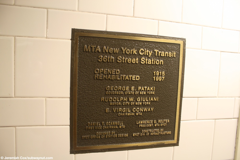
- ^ Cox, Jeremiah (June 6, 2009). "The renovations plaque at 36th Street: Opened 1915, Renovated 1997". subwaynut.com. Retrieved December 18, 2018.
- ^ April 1996 NYC Transit Committee Agenda. New York City Transit. p. 194.
- ^ "36th Street Owen Smith An Underground Movement: Designers, Builders, Riders, 1998". mta.info. Metropolitan Transportation Authority. Retrieved April 19, 2020.
- ^ "A Sweeping Plan to Fix the Subways Comes With a $19 Billion Price Tag". The New York Times. May 22, 2018. ISSN 0362-4331. Retrieved May 23, 2018.
- ^ "Transform the Subway" (PDF). Fast Forward. Metropolitan Transportation Authority. May 23, 2018. p. 41. Retrieved May 23, 2018.
- ^ Guse, Clayton (September 16, 2019). "MTA announces $51 billion plan to save the subway, treat NYC's transit sickness". New York Daily News. Retrieved September 16, 2019.
- ^ "MTA Announces 20 Additional Subway Stations to Receive Accessibility Improvements Under Proposed 2020-2024 Capital Plan". mta.info. Metropolitan Transportation Authority. December 19, 2019. Retrieved December 20, 2019.
- ^ "MTA unveils nearly full list of subway stations to receive elevators". amNewYork. December 19, 2019. Retrieved December 20, 2019.
- ^ "Subway Map" (PDF). Metropolitan Transportation Authority. September 2021. Retrieved September 17, 2021.
- ^ Feinman, Mark S.; Darlington, Peggy; Pirmann, David; Brennan, Joe. "BMT 4th Avenue Line". nycsubway.org. Retrieved December 28, 2020.
- ^ Jump up to: a b c "36th Street Neighborhood Map". mta.info. Metropolitan Transportation Authority. April 2018. Retrieved December 28, 2020.
- ^ https://www.youtube.com/watch?v=BPjuw5I22To The bellmouth can be seen at 58 seconds (0:58) into this video, just before the 36th Street Station.
External links[]
| Wikimedia Commons has media related to 36th Street (BMT Fourth Avenue Line). |
- nycsubway.org – BMT 4th Avenue Line: 36th Street
- Station Reporter — D Train
- Station Reporter — N Train
- Station Reporter — R Train
- The Subway Nut — 36th Street Pictures Archived July 6, 2020, at the Wayback Machine
- MTA's Arts For Transit — 36th Street (BMT Fourth Avenue Line)
- 36th Street entrance from Google Maps Street View
- Platform from Google Maps Street View
- Future accessible New York City Subway stations
- BMT Fourth Avenue Line stations
- New York City Subway stations in Brooklyn
- New York City Subway stations located underground
- Railway stations in the United States opened in 1915
- 1915 establishments in New York (state)
- Sunset Park, Brooklyn