Bowling Green station
Bowling Green | |||||||||||||||||||||||||||||||||||||||||||||||||||||||||||||||||||||||||||||||||||||||||||||||||||||||||||||||||||||||||||||||||||||||||||||||||||||||||||||||||||||||||||||||||||||||||||||||||||||||||||||||||||||||||
|---|---|---|---|---|---|---|---|---|---|---|---|---|---|---|---|---|---|---|---|---|---|---|---|---|---|---|---|---|---|---|---|---|---|---|---|---|---|---|---|---|---|---|---|---|---|---|---|---|---|---|---|---|---|---|---|---|---|---|---|---|---|---|---|---|---|---|---|---|---|---|---|---|---|---|---|---|---|---|---|---|---|---|---|---|---|---|---|---|---|---|---|---|---|---|---|---|---|---|---|---|---|---|---|---|---|---|---|---|---|---|---|---|---|---|---|---|---|---|---|---|---|---|---|---|---|---|---|---|---|---|---|---|---|---|---|---|---|---|---|---|---|---|---|---|---|---|---|---|---|---|---|---|---|---|---|---|---|---|---|---|---|---|---|---|---|---|---|---|---|---|---|---|---|---|---|---|---|---|---|---|---|---|---|---|---|---|---|---|---|---|---|---|---|---|---|---|---|---|---|---|---|---|---|---|---|---|---|---|---|---|---|---|---|---|---|---|---|
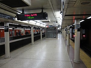 Platform for trains going to Brooklyn (right) | |||||||||||||||||||||||||||||||||||||||||||||||||||||||||||||||||||||||||||||||||||||||||||||||||||||||||||||||||||||||||||||||||||||||||||||||||||||||||||||||||||||||||||||||||||||||||||||||||||||||||||||||||||||||||
| Station statistics | |||||||||||||||||||||||||||||||||||||||||||||||||||||||||||||||||||||||||||||||||||||||||||||||||||||||||||||||||||||||||||||||||||||||||||||||||||||||||||||||||||||||||||||||||||||||||||||||||||||||||||||||||||||||||
| Address | Battery Place & Broadway New York, NY 10004 | ||||||||||||||||||||||||||||||||||||||||||||||||||||||||||||||||||||||||||||||||||||||||||||||||||||||||||||||||||||||||||||||||||||||||||||||||||||||||||||||||||||||||||||||||||||||||||||||||||||||||||||||||||||||||
| Borough | Manhattan | ||||||||||||||||||||||||||||||||||||||||||||||||||||||||||||||||||||||||||||||||||||||||||||||||||||||||||||||||||||||||||||||||||||||||||||||||||||||||||||||||||||||||||||||||||||||||||||||||||||||||||||||||||||||||
| Locale | Financial District | ||||||||||||||||||||||||||||||||||||||||||||||||||||||||||||||||||||||||||||||||||||||||||||||||||||||||||||||||||||||||||||||||||||||||||||||||||||||||||||||||||||||||||||||||||||||||||||||||||||||||||||||||||||||||
| Coordinates | 40°42′15″N 74°00′52″W / 40.70417°N 74.01444°WCoordinates: 40°42′15″N 74°00′52″W / 40.70417°N 74.01444°W | ||||||||||||||||||||||||||||||||||||||||||||||||||||||||||||||||||||||||||||||||||||||||||||||||||||||||||||||||||||||||||||||||||||||||||||||||||||||||||||||||||||||||||||||||||||||||||||||||||||||||||||||||||||||||
| Division | A (IRT)[1] | ||||||||||||||||||||||||||||||||||||||||||||||||||||||||||||||||||||||||||||||||||||||||||||||||||||||||||||||||||||||||||||||||||||||||||||||||||||||||||||||||||||||||||||||||||||||||||||||||||||||||||||||||||||||||
| Line | IRT Lexington Avenue Line | ||||||||||||||||||||||||||||||||||||||||||||||||||||||||||||||||||||||||||||||||||||||||||||||||||||||||||||||||||||||||||||||||||||||||||||||||||||||||||||||||||||||||||||||||||||||||||||||||||||||||||||||||||||||||
| Services | 4 5 | ||||||||||||||||||||||||||||||||||||||||||||||||||||||||||||||||||||||||||||||||||||||||||||||||||||||||||||||||||||||||||||||||||||||||||||||||||||||||||||||||||||||||||||||||||||||||||||||||||||||||||||||||||||||||
| Transit | |||||||||||||||||||||||||||||||||||||||||||||||||||||||||||||||||||||||||||||||||||||||||||||||||||||||||||||||||||||||||||||||||||||||||||||||||||||||||||||||||||||||||||||||||||||||||||||||||||||||||||||||||||||||||
| Structure | Underground | ||||||||||||||||||||||||||||||||||||||||||||||||||||||||||||||||||||||||||||||||||||||||||||||||||||||||||||||||||||||||||||||||||||||||||||||||||||||||||||||||||||||||||||||||||||||||||||||||||||||||||||||||||||||||
| Platforms | 1 side platform 2 island platforms (1 in use, 1 abandoned) | ||||||||||||||||||||||||||||||||||||||||||||||||||||||||||||||||||||||||||||||||||||||||||||||||||||||||||||||||||||||||||||||||||||||||||||||||||||||||||||||||||||||||||||||||||||||||||||||||||||||||||||||||||||||||
| Tracks | 2 | ||||||||||||||||||||||||||||||||||||||||||||||||||||||||||||||||||||||||||||||||||||||||||||||||||||||||||||||||||||||||||||||||||||||||||||||||||||||||||||||||||||||||||||||||||||||||||||||||||||||||||||||||||||||||
| Other information | |||||||||||||||||||||||||||||||||||||||||||||||||||||||||||||||||||||||||||||||||||||||||||||||||||||||||||||||||||||||||||||||||||||||||||||||||||||||||||||||||||||||||||||||||||||||||||||||||||||||||||||||||||||||||
| Opened | July 10, 1905 | ||||||||||||||||||||||||||||||||||||||||||||||||||||||||||||||||||||||||||||||||||||||||||||||||||||||||||||||||||||||||||||||||||||||||||||||||||||||||||||||||||||||||||||||||||||||||||||||||||||||||||||||||||||||||
| Station code | 414[3] | ||||||||||||||||||||||||||||||||||||||||||||||||||||||||||||||||||||||||||||||||||||||||||||||||||||||||||||||||||||||||||||||||||||||||||||||||||||||||||||||||||||||||||||||||||||||||||||||||||||||||||||||||||||||||
| Accessible | |||||||||||||||||||||||||||||||||||||||||||||||||||||||||||||||||||||||||||||||||||||||||||||||||||||||||||||||||||||||||||||||||||||||||||||||||||||||||||||||||||||||||||||||||||||||||||||||||||||||||||||||||||||||||
| Opposite- direction transfer | Yes | ||||||||||||||||||||||||||||||||||||||||||||||||||||||||||||||||||||||||||||||||||||||||||||||||||||||||||||||||||||||||||||||||||||||||||||||||||||||||||||||||||||||||||||||||||||||||||||||||||||||||||||||||||||||||
| Traffic | |||||||||||||||||||||||||||||||||||||||||||||||||||||||||||||||||||||||||||||||||||||||||||||||||||||||||||||||||||||||||||||||||||||||||||||||||||||||||||||||||||||||||||||||||||||||||||||||||||||||||||||||||||||||||
| 2019 | 8,362,034[5] | ||||||||||||||||||||||||||||||||||||||||||||||||||||||||||||||||||||||||||||||||||||||||||||||||||||||||||||||||||||||||||||||||||||||||||||||||||||||||||||||||||||||||||||||||||||||||||||||||||||||||||||||||||||||||
| Rank | 39 out of 424[5] | ||||||||||||||||||||||||||||||||||||||||||||||||||||||||||||||||||||||||||||||||||||||||||||||||||||||||||||||||||||||||||||||||||||||||||||||||||||||||||||||||||||||||||||||||||||||||||||||||||||||||||||||||||||||||
| Station succession | |||||||||||||||||||||||||||||||||||||||||||||||||||||||||||||||||||||||||||||||||||||||||||||||||||||||||||||||||||||||||||||||||||||||||||||||||||||||||||||||||||||||||||||||||||||||||||||||||||||||||||||||||||||||||
| Next north | Wall Street: 4 | ||||||||||||||||||||||||||||||||||||||||||||||||||||||||||||||||||||||||||||||||||||||||||||||||||||||||||||||||||||||||||||||||||||||||||||||||||||||||||||||||||||||||||||||||||||||||||||||||||||||||||||||||||||||||
| Next south | (Terminal): 5 South Ferry (loops; closed): no service Borough Hall: 4 | ||||||||||||||||||||||||||||||||||||||||||||||||||||||||||||||||||||||||||||||||||||||||||||||||||||||||||||||||||||||||||||||||||||||||||||||||||||||||||||||||||||||||||||||||||||||||||||||||||||||||||||||||||||||||
| |||||||||||||||||||||||||||||||||||||||||||||||||||||||||||||||||||||||||||||||||||||||||||||||||||||||||||||||||||||||||||||||||||||||||||||||||||||||||||||||||||||||||||||||||||||||||||||||||||||||||||||||||||||||||
| |||||||||||||||||||||||||||||||||||||||||||||||||||||||||||||||||||||||||||||||||||||||||||||||||||||||||||||||||||||||||||||||||||||||||||||||||||||||||||||||||||||||||||||||||||||||||||||||||||||||||||||||||||||||||
| |||||||||||||||||||||||||||||||||||||||||||||||||||||||||||||||||||||||||||||||||||||||||||||||||||||||||||||||||||||||||||||||||||||||||||||||||||||||||||||||||||||||||||||||||||||||||||||||||||||||||||||||||||||||||
| |||||||||||||||||||||||||||||||||||||||||||||||||||||||||||||||||||||||||||||||||||||||||||||||||||||||||||||||||||||||||||||||||||||||||||||||||||||||||||||||||||||||||||||||||||||||||||||||||||||||||||||||||||||||||
Battery Park Control House | |||||||||||||||||||||||||||||||||||||||||||||||||||||||||||||||||||||||||||||||||||||||||||||||||||||||||||||||||||||||||||||||||||||||||||||||||||||||||||||||||||||||||||||||||||||||||||||||||||||||||||||||||||||||||
U.S. National Register of Historic Places | |||||||||||||||||||||||||||||||||||||||||||||||||||||||||||||||||||||||||||||||||||||||||||||||||||||||||||||||||||||||||||||||||||||||||||||||||||||||||||||||||||||||||||||||||||||||||||||||||||||||||||||||||||||||||
NYC Landmark No. 0829
| |||||||||||||||||||||||||||||||||||||||||||||||||||||||||||||||||||||||||||||||||||||||||||||||||||||||||||||||||||||||||||||||||||||||||||||||||||||||||||||||||||||||||||||||||||||||||||||||||||||||||||||||||||||||||
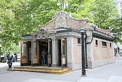 Station headhouse on Battery Park dates to 1905 | |||||||||||||||||||||||||||||||||||||||||||||||||||||||||||||||||||||||||||||||||||||||||||||||||||||||||||||||||||||||||||||||||||||||||||||||||||||||||||||||||||||||||||||||||||||||||||||||||||||||||||||||||||||||||
 Location of station in New York City | |||||||||||||||||||||||||||||||||||||||||||||||||||||||||||||||||||||||||||||||||||||||||||||||||||||||||||||||||||||||||||||||||||||||||||||||||||||||||||||||||||||||||||||||||||||||||||||||||||||||||||||||||||||||||
| Coordinates | 40°42′15″N 74°00′52″W / 40.704106°N 74.014521°W | ||||||||||||||||||||||||||||||||||||||||||||||||||||||||||||||||||||||||||||||||||||||||||||||||||||||||||||||||||||||||||||||||||||||||||||||||||||||||||||||||||||||||||||||||||||||||||||||||||||||||||||||||||||||||
| Built | 1905 | ||||||||||||||||||||||||||||||||||||||||||||||||||||||||||||||||||||||||||||||||||||||||||||||||||||||||||||||||||||||||||||||||||||||||||||||||||||||||||||||||||||||||||||||||||||||||||||||||||||||||||||||||||||||||
| Architect | Heins & LaFarge | ||||||||||||||||||||||||||||||||||||||||||||||||||||||||||||||||||||||||||||||||||||||||||||||||||||||||||||||||||||||||||||||||||||||||||||||||||||||||||||||||||||||||||||||||||||||||||||||||||||||||||||||||||||||||
| MPS | Interborough Rapid Transit Subway Control Houses TR | ||||||||||||||||||||||||||||||||||||||||||||||||||||||||||||||||||||||||||||||||||||||||||||||||||||||||||||||||||||||||||||||||||||||||||||||||||||||||||||||||||||||||||||||||||||||||||||||||||||||||||||||||||||||||
| NRHP reference No. | 80002669 | ||||||||||||||||||||||||||||||||||||||||||||||||||||||||||||||||||||||||||||||||||||||||||||||||||||||||||||||||||||||||||||||||||||||||||||||||||||||||||||||||||||||||||||||||||||||||||||||||||||||||||||||||||||||||
| NYCL No. | 0829 | ||||||||||||||||||||||||||||||||||||||||||||||||||||||||||||||||||||||||||||||||||||||||||||||||||||||||||||||||||||||||||||||||||||||||||||||||||||||||||||||||||||||||||||||||||||||||||||||||||||||||||||||||||||||||
| Significant dates | |||||||||||||||||||||||||||||||||||||||||||||||||||||||||||||||||||||||||||||||||||||||||||||||||||||||||||||||||||||||||||||||||||||||||||||||||||||||||||||||||||||||||||||||||||||||||||||||||||||||||||||||||||||||||
| Added to NRHP | May 6, 1980[7] | ||||||||||||||||||||||||||||||||||||||||||||||||||||||||||||||||||||||||||||||||||||||||||||||||||||||||||||||||||||||||||||||||||||||||||||||||||||||||||||||||||||||||||||||||||||||||||||||||||||||||||||||||||||||||
| Designated NYCL | November 20, 1973[6] | ||||||||||||||||||||||||||||||||||||||||||||||||||||||||||||||||||||||||||||||||||||||||||||||||||||||||||||||||||||||||||||||||||||||||||||||||||||||||||||||||||||||||||||||||||||||||||||||||||||||||||||||||||||||||


Bowling Green is a station on the IRT Lexington Avenue Line of the New York City Subway, located at Broadway and Battery Place (at Bowling Green), in the Financial District of Manhattan. It is served by the 4 train at all times and the 5 train at all times except late nights.
The station opened in 1905 as an extension of the Interborough Rapid Transit (IRT)'s original subway line to South Ferry. At the time, there was a single island platform with one exit at Battery Park and another in Bowling Green. When the Lexington Avenue Line was expanded to Brooklyn in 1908, some trains continued going to South Ferry, resulting in the creation of a short island platform at the Bowling Green station for the Bowling Green–South Ferry shuttle. The shuttle operated until 1977. During the 1970s, the station was completely renovated, a new exit was built, and a third, side platform was created for northbound trains.
The Bowling Green station contains three platforms: two island platforms and one side platform. The westernmost island platform, used by the shuttle, has not been in use since 1977. The station retains its original head house in Battery Park, which is listed on the National Register of Historic Places and a New York City designated landmark. There are two other exits to Bowling Green, one of which contains an elevator that makes the station compliant with the Americans with Disabilities Act of 1990.
History[]
Construction and opening[]

Planning for a subway line in New York City dates to 1864.[8]: 21 However, development of what would become the city's first subway line did not start until 1894, when the New York State Legislature authorized the Rapid Transit Act.[8]: 139–161 The subway plans were drawn up by a team of engineers led by William Barclay Parsons, chief engineer of the Rapid Transit Commission.[9]: 3 The Rapid Transit Construction Company, organized by John B. McDonald and funded by August Belmont Jr., signed the initial Contract 1 with the Rapid Transit Commission in February 1900,[10] in which it would construct the subway and maintain a 50-year operating lease from the opening of the line.[8]: 165 In 1901, the firm of Heins & LaFarge was hired to design the underground stations.[9]: 4 Belmont incorporated the Interborough Rapid Transit Company (IRT) in April 1902 to operate the subway.[8]: 162–191
Several days after Contract 1 was signed, the Board of Rapid Transit Railroad Commissioners instructed Parsons to evaluate the feasibility of extending the subway south to South Ferry, and then to Brooklyn. On January 24, 1901, the Board adopted a route that would extend the subway from City Hall to the Long Island Rail Road (LIRR)'s Flatbush Avenue terminal station (now known as Atlantic Terminal) in Brooklyn, via the Joralemon Street Tunnel under the East River.[11]: 83–84 [12]: 260–261 Contract 2, giving a lease of 35 years, was executed between the commission and the Rapid Transit Construction Company on September 11, 1902. Construction began at State Street in Manhattan on November 8, 1902.[8]: 162–191
The Bowling Green station, constructed as part of Contract 2, opened on July 10, 1905.[13] The station was originally built with a single island platform; a station head house at the south end, in Battery Park; and a secondary entrance at the northern end of the platform, adjacent to Bowling Green Park.[14] There was as yet no Interborough Rapid Transit (IRT) service to Brooklyn, and all Lexington Avenue trains terminated at South Ferry's outer-loop platform.[13]
Early modifications[]

The Joralemon Street Tunnel opened in 1908.[15] Some trains continued to terminate at South Ferry, even during rush hours, while others went to Brooklyn. This service pattern was soon found to be inadequate for the high volume of Brooklyn riders.[16] As a result, in 1908, the New York State Public Service Commission applied for authority to build a second, shorter platform and a third track to the west of the existing island platform.[16] Three months after the Joralemon Street Tunnel opened, construction began on the third track and the western island platform at Bowling Green. Once they were completed in 1909, all rush-hour trains were sent to Brooklyn, with a two-car Bowling Green–South Ferry shuttle train providing service to South Ferry during those times. Even after the IRT Broadway–Seventh Avenue Line local service (1 train) began to South Ferry in 1918, the shuttle remained in operation until it was discontinued in 1977 due to budget cuts.[17]
To address overcrowding, in 1909, the New York Public Service Commission proposed lengthening platforms at stations along the original IRT subway.[18]: 168 As part of a modification to the IRT's construction contracts, made on January 18, 1910, the company was to lengthen station platforms to accommodate ten-car express and six-car local trains. In addition to $1.5 million (equivalent to $41.7 million in 2020) spent on platform lengthening, $500,000 (equivalent to $13,887,500 in 2020) was spent on building additional entrances and exits. It was anticipated that these improvements would increase capacity by 25 percent.[19]: 15 The main island platform at the Bowling Green station was extended 110 feet (34 m) to the north.[19]: 116 On January 23, 1911, ten-car express trains began running on the East Side Line, and the next day, ten-car express trains began running on the West Side Line.[18]: 168 [20] In Fiscal Year 1937, the north end of the platform was extended 102 feet (31 m) to avoid the need to install gap fillers on the curve at the south end of the platform.[21]
On September 8, 1952, the New York City Board of Transportation made the entrance kiosk at Battery Place and State Street entrance-only instead of exit-only in order to relieve congestion at the station during the evening rush hour. A fare box was installed at the top of the stairway to accommodate the change.[22] In 1959, a new station house in Bowling Green Park was completed, with new stairways to the platform. In late 1959, contracts were awarded to extend the platforms at Bowling Green, Wall Street, Fulton Street, Canal Street, Spring Street, Bleecker Street, Astor Place, Grand Central, 86th Street and 125th Street to 525 feet (160 m) to accommodate ten-car trains.[23][24]
Renovation[]

On March 5, 1972, the Metropolitan Transportation Authority (MTA) announced that the station would be renovated and expanded, doubling the capacity of the station, with work initially set to finished in 1974.[25] The work was done in conjunction with the renovation of Bowling Green Park, which was rebuilt to conform with its appearance in the late 1700s.[26][27]
As part of the project, a new northbound side platform was built to alleviate congestion on the narrow island platform, which would then only be used by downtown trains.[28] In addition, stairs and a new mezzanine were built below track level, and a new exit with modern escalators was installed just south of Bowling Green, funneling some of the traffic away from the control house exit at the south end.[28][29] The addition of this new entrance, and the expansion of the park, was made possible by closing the street named Bowling Green and turning it into a pedestrian plaza.[30][31]
The new mezzanine was connected to the platform and street levels with ten new escalators. The capacity improvements were made by excavating using the cut-and-cover method in Bowling Green Park.[32] The existing subway entrance at the west gate of the park was removed, providing more open space in the park. These capacity improvements were made to accommodate increased ridership resulting from the construction of additional office buildings in Lower Manhattan, including the World Trade Center.[25] As part of the station renovation, it lost its historic mosaic tiles,[33][34] which were replaced with bright red tiles, consistent with station renovation projects at 49th Street and the under-construction stations on the 63rd Street lines and Archer Avenue lines.[35] In addition, the station's token booths were renovated.[36]
On July 14, 1975, it was announced that the project's completion was then delayed to March 1976.[37] The southern headhouse entrance was closed for six months beginning in April 1978 as it was being rehabilitated.[38] The renovation was completed in 1978 at a cost of $16.8 million.[37] Funding for the project was provided from the New York City Transit Authority (NYCTA)'s capital budget.[25]
At midnight on February 13, 1977, service on the Bowling Green–South Ferry shuttle was discontinued, and the platform and the track used by the shuttle were abandoned. Service was discontinued as part of a three-phase cut in service that the NYCTA had begun in 1975 to reduce its operating deficits.[39][40][41] Despite the discontinuation of the service, the shuttle platform was renovated as part of the station renovation project, receiving new tiling, signage, and refinished flooring.[42][43][44] Some time after 1983, a fence was installed on the eastern edge of the island platform, which had been used to board trains prior to the opening of the side platform in 1978.[45]
Subsequent improvements[]
In June 1999, MetroCard vending machines were installed in this station as part of the second batch of the fare-payment technology's installation.[46] In early 2006, work began to make the station fully compliant with the Americans with Disabilities Act of 1990. As part of the project, the cobblestones around the station entrance near Bowling Green were replaced with granite pavers, an ADA-compliant path was constructed to Bowling Green Park, and a new glass canopy was installed over this entrance. The canopy, which was designed by Dattner Architects in 2003, consists of a curved steel and glass with stainless steel ribs, and is supported by a granite base.[47] As part of the project, the unused shuttle platform was walled off between 2001 and 2002.[43][48][49]
Work to install the canopy was scheduled to begin in late October 2006.[50] In May 2007, the replacement of the cobblestones and installation of the glass canopy were completed. The elevators opened on July 9, 2007, but were formally opened the following day.[51][52]
In 2020, the MTA tested a hearing induction loop for hard-of-hearing passengers on the northbound platform, the first such installation in the subway system.[53][54]
Station layout[]
| G | Street level | Exit/entrance |
| P Platform level |
Side platform | |
| Northbound | ← ← | |
| Island platform, southbound use only | ||
| Southbound | (no service: South Ferry loops) → | |
| Island platform, not in service | ||
| Shuttle | No passenger service (South Ferry loops) | |
| M | Mezzanine | Fare control, station agent |

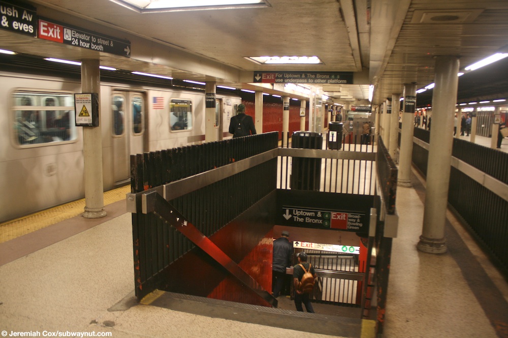
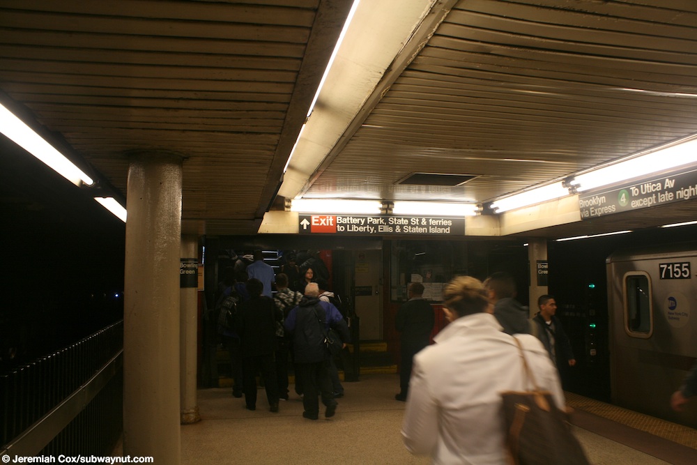
The station, located at Broadway and Battery Place,[55] has two tracks and two platforms in service: a center island platform that serves southbound and terminating trains, and a side platform that serves northbound trains.[56] A fence is located along the edge of the island platform, preventing northbound trains from releasing passengers onto the island platform.[57][58] The side platform and the wall facing the downtown track have orange brick tiles.[59] Both platforms have circular platform columns painted in beige.[57]
An abandoned and walled-off island platform and track on the west side of the station were formerly used by the Bowling Green–South Ferry shuttle, which traveled to the inner platform at South Ferry.[56][60] This platform was connected to the island platform with an underpass at its northern end.[49][61]
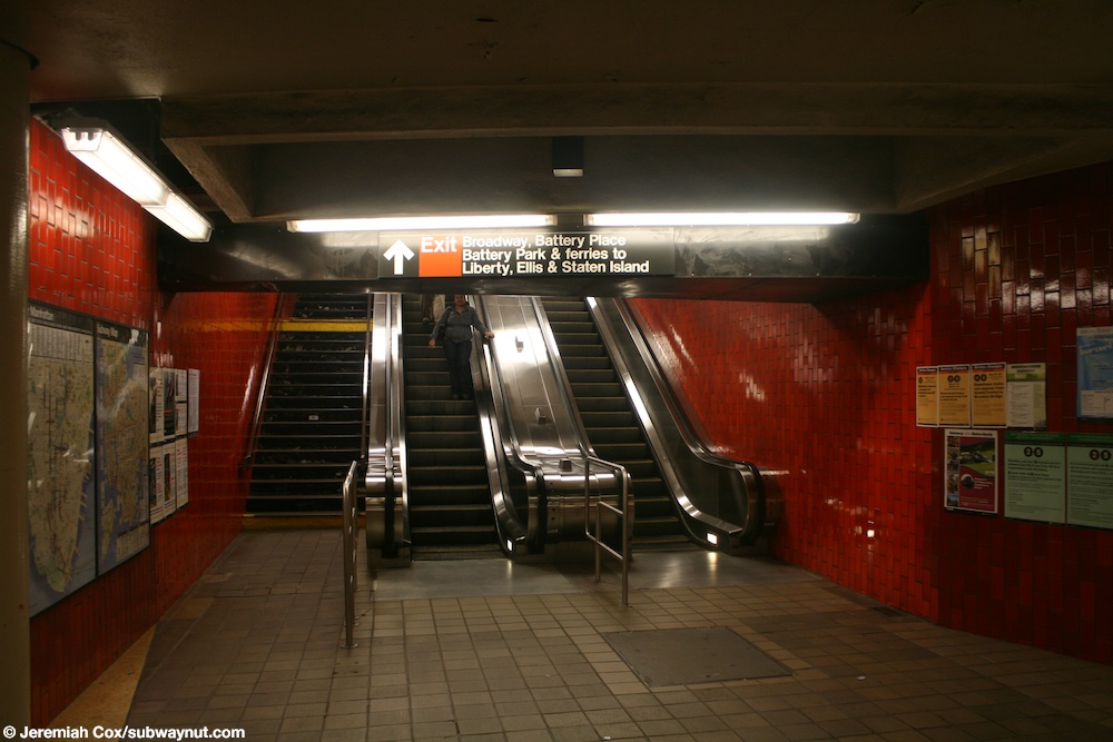
Escalators and stairs connect both platforms to the mezzanine below track level, where free transfers can be made between the two platforms.[62] On the uptown platform, pairs of escalators and staircases lead to the mezzanine,[63][64] while on the downtown platform, alternating staircases and escalators descend to the mezzanine.[65]
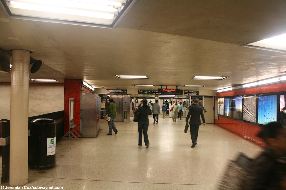
There are two banks of turnstiles on the north and south sides of the mezzanine, which is outside fare control.[66] A pair of escalators and a staircase leads from the eastern end of the mezzanine to an upper mezzanine,[67] which contains the token booth, and a bank of turnstiles, which leads directly onto the uptown side platform.[68]
Two elevators make the station accessible under the Americans with Disabilities Act of 1990. One connects street level, the main northbound fare control, and the southbound fare control area below the platforms and tracks. The other connects the Brooklyn-bound platform with the fare control area below.[69]
Track layout[]
South of the station, the tracks diverge into two sets. One set (the inner tracks) enters the Joralemon Street Tunnel to travel to Brooklyn.[56] this route is used by the 4 train at all times and the 5 train on weekdays until 8:45 pm.[70] The outer tracks continue to the closed South Ferry inner loop station,[56] which is used by the 5 train when it short turns at this station during weekends and late weekday evenings.[70]
Exits[]

The station has three street stairs, an elevator, a set of escalators, and an original control house (also known as a head house). These exits are clustered in three separate locations.[55][71]
The eastern end of the upper mezzanine, toward the center of the station, leads to a pair of staircases and an up escalator that leads to Bowling Green plaza.[72] There is a glass-canopied stairs-and-escalator entrance in front of the Alexander Hamilton U.S. Custom House, just around the corner from two entrances to the Whitehall Street–South Ferry station on the BMT Broadway Line (which are set into the building's eastern elevation).[55][71]
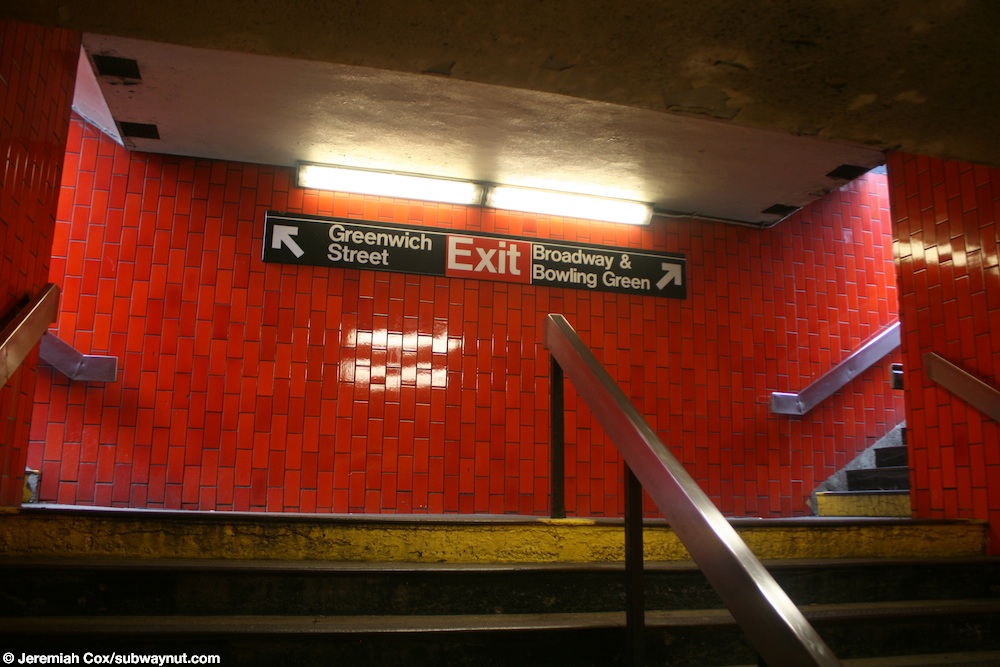
At the eastern end of the lower mezzanine, a pair of escalators and a staircase lead to an intermediate level.[73][74] This, in turn, leads to a pair of staircases on the north side of Battery Place between Greenwich Street and Broadway, outside the International Mercantile Marine Company Building.[55][71]
A staircase, at the southern end of the island platform, leads to a fare control area in the restored control house.[75] which consists of a pair of low turnstiles at the south end,[76] and two high entry/exit turnstiles flanking the staircase down to the platform.[77]
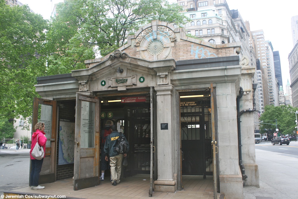
Control house[]
At the south end of the station is the original head house, known as the Bowling Green IRT Control House or Battery Park Control House, on the west side of State Street south of Broadway.[55] This subway entrance was designed by Heins & LaFarge and built in 1905 on the west side of State Street, across from the Alexander Hamilton U.S. Custom House.[78] It was built as one of several station houses on the original IRT; similar station houses were built at 72nd, 96th, 103rd, and 116th Streets.[79]: 46 [80]: 2 The control house is listed on the National Register of Historic Places and is a New York City designated landmark.[6][7] Although most of the original subway's entry points had steel and glass kiosks (such as at Astor Place), important stations like Bowling Green were marked with a brick and stone control house, so called because they helped control the passenger flow.[6]
The facade is made of yellow brick, with limestone banding and triglyphs at its tops, a base of granite, and a gable roof. The doorways to the control house are located on the north and south of the structure; the northern doorway has an elaborate pediment above it, and the southern doorway has been extended with three exit doors. Inside, the control house has turnstiles at street level and a single stair down to the extreme southern end of the island platform.[6]
Lower Manhattan transit | ||||||||||||||||||||||||||||||||||||||||||||||||||||||||||||||||||||||||||||||||||||||||||||||||||
|---|---|---|---|---|---|---|---|---|---|---|---|---|---|---|---|---|---|---|---|---|---|---|---|---|---|---|---|---|---|---|---|---|---|---|---|---|---|---|---|---|---|---|---|---|---|---|---|---|---|---|---|---|---|---|---|---|---|---|---|---|---|---|---|---|---|---|---|---|---|---|---|---|---|---|---|---|---|---|---|---|---|---|---|---|---|---|---|---|---|---|---|---|---|---|---|---|---|---|
| ||||||||||||||||||||||||||||||||||||||||||||||||||||||||||||||||||||||||||||||||||||||||||||||||||
Artwork[]
The Bowling Green station has lightboxes with rotating content. Since 2018, the exhibition has been "Daily Voyage", featuring pictures taken by Glen DiCrocco of regular commuters on the Staten Island Ferry. Some of these photos can be seen on the MTA's Flickr account as well.[81]
Nearby points of interest[]
There are numerous skyscrapers and other structures immediately surrounding the Bowling Green station (listed clockwise):
- Alexander Hamilton U.S. Custom House to the south; a New York City designated landmark on the National Register of Historic Places[82]: 13–14
- International Mercantile Marine Company Building, 1 Broadway; a New York City designated landmark on the National Register of Historic Places[82]: 10
- Bowling Green Offices Building, 11 Broadway; a New York City designated landmark[82]: 12
- Cunard Building, 25 Broadway; a New York City designated landmark[82]: 12
- 26 Broadway, the Standard Oil Company Building, on the east side of Broadway, facing the Cunard Building; a New York City designated landmark[82]: 12
- 2 Broadway, a Modernist glass wall that replaced the distinguished Produce Exchange Building (1881–1884, George B. Post), as an "acceptable sacrifice"[83] intended to spur financial district rebuilding[82]: 13
Another park, the Battery, is located right outside the southern entrance.[71] Charging Bull, a 7,100-pound (3,200 kg) bronze sculpture, is at the north end of Bowling Green Park,[84] immediately north of the station.[71]
References[]
- ^ "Glossary". Second Avenue Subway Supplemental Draft Environmental Impact Statement (SDEIS) (PDF). 1. Metropolitan Transportation Authority. March 4, 2003. pp. 1–2. Archived from the original (PDF) on February 26, 2021. Retrieved January 1, 2021.
- ^ See:
- "Manhattan Bus Map" (PDF). Metropolitan Transportation Authority. July 2019. Retrieved December 1, 2020.
- "Brooklyn Bus Map" (PDF). Metropolitan Transportation Authority. October 2020. Retrieved December 1, 2020.
- "Bronx Bus Service" (PDF). Metropolitan Transportation Authority. October 2018. Retrieved December 1, 2020.
- "Queens Bus Service" (PDF). Metropolitan Transportation Authority. September 2019. Retrieved December 1, 2020.
- "Staten Island Bus Service" (PDF). Metropolitan Transportation Authority. January 2020. Retrieved December 1, 2020.
- ^ "Station Developers' Information". Metropolitan Transportation Authority. Retrieved June 13, 2017.
- ^ "Facts and Figures: Annual Subway Ridership 2014–2019". Metropolitan Transportation Authority. 2020. Retrieved May 26, 2020.
- ^ a b "Facts and Figures: Annual Subway Ridership 2014–2019". Metropolitan Transportation Authority. 2020. Retrieved May 26, 2020.
- ^ a b c d "Interborough Rapid Transit System, Battery Park Control House" (PDF). New York City Landmarks Preservation Commission. November 22, 1973. Retrieved February 2, 2020.
- ^ a b "National Register Information System". National Register of Historic Places. National Park Service. March 13, 2009.
- ^ a b c d e Walker, James Blaine (1918). Fifty Years of Rapid Transit — 1864 to 1917. New York, N.Y.: Law Printing. Retrieved November 6, 2016.
- ^ a b "Interborough Rapid Transit System, Underground Interior" (PDF). New York City Landmarks Preservation Commission. October 23, 1979. Retrieved November 19, 2019.
- ^ Report of the Board of Rapid Transit Railroad Commissioners for the City of New York For The Year Ending December 31, 1904 Accompanied By Reports of the Chief Engineer and of the Auditor. Board of Rapid Transit Railroad Commissioners. 1905. pp. 229–236.
- ^ Report of the Board of Rapid Transit Railroad Commissioners For And In The City of New York Up to December 31, 1901. Board of Rapid Transit Railroad Commissioners. 1902.
- ^ Scott, Charles (1978). "Design and Construction of the IRT: Civil Engineering" (PDF). Historic American Engineering Record. pp. 208–282 (PDF pp. 209–283). Retrieved December 20, 2020.
 This article incorporates text from this source, which is in the public domain.CS1 maint: postscript (link)
- ^ a b "Subway Trains Running from Bronx to Battery; West Farms and South Ferry Stations Open at Midnight" (PDF). The New York Times. July 10, 1905. ISSN 0362-4331. Retrieved September 4, 2016.
- ^ "Photo of Bowling Green Station entrance in Bowling Green Park".
- ^ "Subway to Brooklyn Opened for Traffic". The New York Times. January 9, 1908. p. 1. ISSN 0362-4331. Retrieved November 11, 2016.
- ^ a b Report of the Public Service Commission for the First District of the State of New York. J.B. Lyon Company, printers. 1908. p. 194. Retrieved February 22, 2020.
- ^ Blumenthal, Ralph (January 15, 1977). "Transit Cuts Approved by M.T.A.; Reductions Will Begin Next Month". The New York Times. ISSN 0362-4331. Retrieved March 3, 2010.
- ^ a b Hood, Clifton (1978). "The Impact of the IRT in New York City" (PDF). Historic American Engineering Record. pp. 146–207 (PDF pp. 147–208). Retrieved December 20, 2020. This article incorporates text from this source, which is in the public domain.CS1 maint: postscript (link)
- ^ a b Report of the Public Service Commission for the First District of the State of New York For The Year Ending December 31, 1910. Public Service Commission. 1911.
- ^ "Ten-car Trains in Subway to-day; New Service Begins on Lenox Av. Line and Will Be Extended to Broadway To-morrow". The New York Times. January 23, 1911. ISSN 0362-4331. Retrieved April 5, 2018.
- ^ Legislative Document. New York State Transit Commission. 1937. p. 15.
- ^ "New Subway Entrance Is Added". The New York Times. September 9, 1952. ISSN 0362-4331. Retrieved March 27, 2020.
- ^ Annual Report For The Year Ending June 30, 1959 (PDF). New York City Transit Authority. 1959. pp. 8–10.
- ^ New York City Transit Authority Annual Report For The Year Ended June 30, 1960. New York City Transit Authority. 1960. p. 15.
- ^ a b c McFadden, Robert D. (March 6, 1972). "Bowling Green Park to Get Dutch Flavor Back". The New York Times. ISSN 0362-4331. Retrieved March 27, 2020.
- ^ Haitch, Richard (December 19, 1976). "Follow‐Up on The News". The New York Times. ISSN 0362-4331. Retrieved February 22, 2020.
- ^ "Front Page 1 ‐‐ No Title". The New York Times. September 24, 1977. ISSN 0362-4331. Retrieved February 22, 2020.
- ^ a b Dembart, Lee (February 18, 1977). "Catch the Subway of the Future". The New York Times. ISSN 0362-4331. Retrieved February 22, 2020.
- ^ "City Announces Plan For the Improvement Of Subway Stations". The New York Times. March 14, 1979. ISSN 0362-4331. Retrieved February 22, 2020.
- ^ "New York Affairs". Urban Affairs. Institute for the Study of the City. 5 (1): 86. 1978.
- ^ "Map Showing A Change In The City Map By Laying Out The Lines And Dimensions Of Bowling Green Park And A Public Place Within The Area Generally Bounded By Broadway And Bowling Green Borough of Manhattan" (PDF). Office of the President, Borough of Manhattan Topographical Bureau. January 28, 1980. Retrieved March 27, 2020.
- ^ Annual Report. Metropolitan Transportation Authority. 1973. p. 5.
- ^ Pirmann, David. "Heins & La Farge mosaic tapestry on side trackway wall-no longer present". nycsubway.org. Retrieved March 27, 2020.
- ^ Coppella, Phillip (May 15, 2018). One-Track Mind: Drawing the New York Subway. Chronicle Books. pp. 116–117. ISBN 978-1-61689-731-4.
- ^ Levine, Richard (March 30, 1987). "Saving the Subway's Last Mosaics". The New York Times. ISSN 0362-4331. Retrieved March 27, 2020.
- ^ Rosen, Richard (February 3, 1981). "For mass transit, a touch of class". New York Daily News. Retrieved March 27, 2020 – via newspapers.com
 .
.
- ^ a b "Bowling Green IRT Work". The New York Times. July 15, 1975. ISSN 0362-4331. Retrieved February 22, 2020.
- ^ Gitlow, Stuart (1978). "Bowling Green headhouse entrance closed for repairs". nycsubway.org. Retrieved March 27, 2020.
- ^ Mazza, Frank (August 31, 1976). "K Train's Gone and the Rest Are EEE-e-e". New York Daily News. Retrieved January 8, 2019 – via newspapers.com .
- ^ Edmonds, Richard (August 14, 1976). "TA to Eliminate 215 Subway Runs". New York Daily News. Retrieved January 8, 2019 – via newspapers.com .
- ^ "M.T.A. Expected to Save Franklin Avenue Shuttle, Once an Austerity Target". The New York Times. February 10, 1977. p. 27. ISSN 0362-4331. Retrieved July 18, 2010.
- ^ Grotjahn, Doug (February 12, 1977). "Shuttle train at Bowling Green". nycsubway.org. Retrieved March 27, 2020.
- ^ a b Pirmann, David (July 11, 2000). "Disused side platform and shuttle trackway (against wall)". nycsubway.org. Retrieved March 27, 2020.
- ^ Grotjahn, Doug (December 15, 1970). "R12 cars on the Bowling Green Shuttle". nycsubway.org. Retrieved March 27, 2020.
- ^ Fiori, Charles (August 1983). "A 4 train of R17 subway cars entering Bowling Green". nycsubway.org. Retrieved March 27, 2020.
- ^ "Metro News Briefs: New York; City to Add Machines That Sell Metrocards". The New York Times. June 11, 1999. ISSN 0362-4331. Retrieved March 27, 2020.
- ^ Dattner Architects. Richard Dattner & Partners Architects. 2008. p. 122. ISBN 978-1-86470-285-9.
- ^ Fedow, Bruce (November 17, 2005). "Disused shuttle platform at Bowling Green". nycsubway.org. Retrieved March 27, 2020.
- ^ a b Brennan, Joseph (2002). "Abandoned Stations : Bowling Green & South Ferry platforms". columbia.edu. Retrieved March 27, 2020.
- ^ "Lower Manhattan: Bowling Green Elevator Installation". lowermanhattan.info. 2006. Archived from the original on October 3, 2006. Retrieved March 27, 2020.
- ^ "Lower Manhattan : Bowling Green Elevator Installation". lowermanhattan.info. July 11, 2007. Archived from the original on October 15, 2007. Retrieved March 27, 2020.
- ^ MTA Board Action Items. Metropolitan Transportation Authority. 2007. p. 3.
- ^ "New York City Transit and Bus Committee Meeting February 2020". mta.info. Metropolitan Transportation Authority. February 24, 2020. p. 88. Retrieved June 23, 2019.
- ^ "Hearing Loop at Bowling Green". mta.info. Metropolitan Transportation Authority. 2020. Retrieved March 27, 2020.
- ^ a b c d e "Bowling Green Neighborhood Maps". mta.info. Metropolitan Transportation Authority. September 2018. Retrieved May 27, 2019.
- ^ a b c d Dougherty, Peter (2020). Tracks of the New York City Subway 2020 (16th ed.). Dougherty. OCLC 1056711733.
- ^ a b Cox, Jeremiah (May 19, 2010). "Looking down the uptown track over the fence viewed from the downtown platform". subwaynut.com. Retrieved March 27, 2020.
- ^ Cox, Jeremiah (December 14, 2003). "The extremely and dangerously narrow northern end of the platform at Bowling Green". subwaynut.com. Retrieved March 27, 2020.
- ^ Cox, Jeremiah (June 13, 2005). "The uptown platform at Bowling Green". subwaynut.com. Retrieved March 27, 2020.
- ^ Liccese, Anthony J. (August 8, 2011). "Closed side platform – former South Ferry shuttle". nycsubway.org. Retrieved March 27, 2020.
- ^ "Composite 3252 at Bowling Green". nycsubway.org. 1910. Retrieved March 27, 2020.
- ^ Cox, Jeremiah (May 20, 2010). "A staircase followed by an elevator down from the downtown trains island platform". subwaynut.com. Retrieved March 27, 2020.
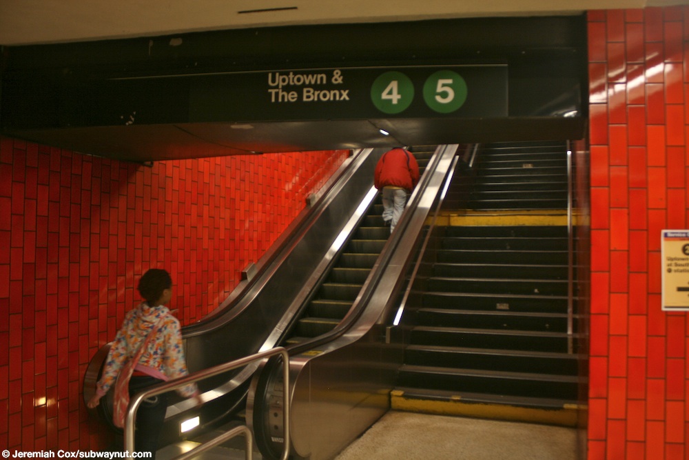
- ^ Cox, Jeremiah (May 20, 2010). "escalator and staircase to the uptown and Bronx platform". subwaynut.com. Retrieved March 27, 2020.
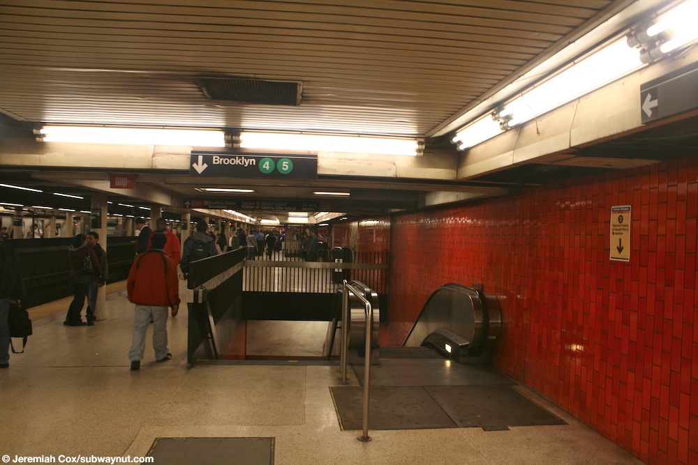
- ^ Cox, Jeremiah (May 20, 2010). "Another escalator/stair bank from the uptown platform for the Brooklyn Platform". subwaynut.com. Retrieved March 27, 2020.
- ^ Cox, Jeremiah (May 20, 2010). "The staircase followed by an escalator up to the relatively narrow Brooklyn 4/5 island platform. There is an unusual white lighted sign". subwaynut.com. Retrieved March 27, 2020.
- ^ Cox, Jeremiah (May 20, 2010). "The small bank of turnstiles to the underpass exit". subwaynut.com. Retrieved March 27, 2020.
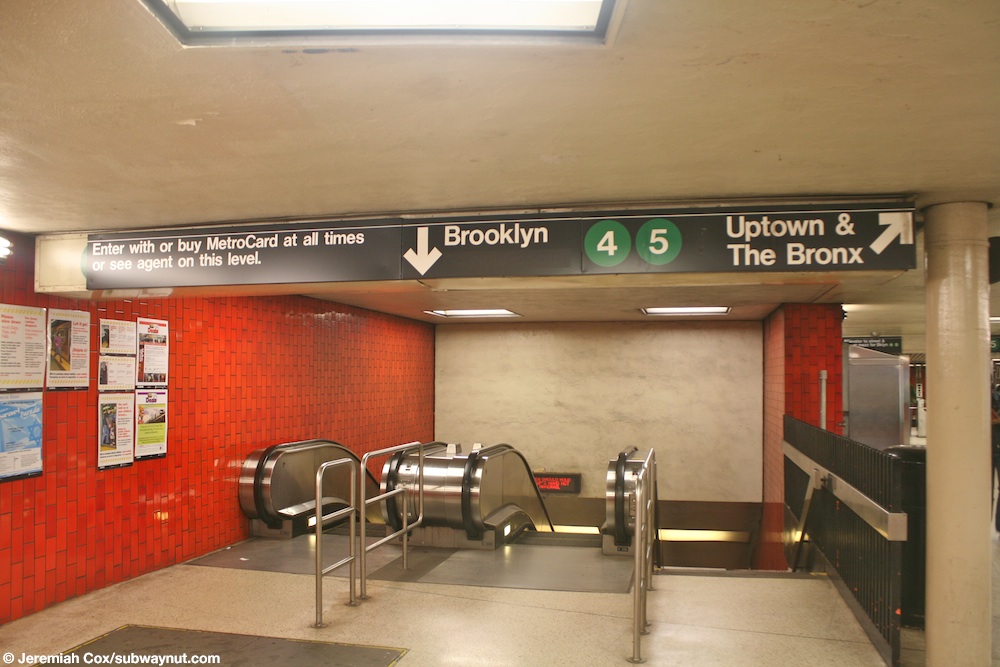
- ^ Cox, Jeremiah (May 19, 2010). "The staircase/escalators down to the underpass level and Brooklyn trains from the upper fare control level, a turnstile to the full time uptown platform entrance is visible". subwaynut.com. Retrieved March 27, 2020.
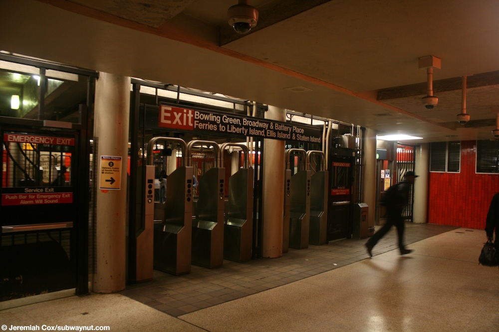
- ^ Cox, Jeremiah (May 19, 2010). "Outside of fare control in the main passage and entrance from Bowling Green Park". subwaynut.com. Retrieved March 27, 2020.
- ^ "Accessibility". mta.info. Metropolitan Transportation Authority. Retrieved March 25, 2020.
- ^ a b "Subway Service Guide" (PDF). Metropolitan Transportation Authority. September 2019. Retrieved September 22, 2019.
- ^ a b c d e "MTA Neighborhood Maps: Lower Manhattan" (PDF). Metropolitan Transportation Authority. 2015. Retrieved October 1, 2018.
- ^ Cox, Jeremiah (May 19, 2010). "The modern with a sleek glass canopy escalator/stair entrance to Bowling Green". subwaynut.com. Retrieved March 27, 2020.
- ^ Cox, Jeremiah (May 20, 2010). "The escalators up to the Battery Place and Battery Park exit at the western end of the underpass mezzanine". subwaynut.com. Archived from the original on March 27, 2020. Retrieved March 27, 2020.
- ^ Cox, Jeremiah (May 20, 2010). "The split for the two different staircases up to the Battery Place & Broadway exit". subwaynut.com. Retrieved March 27, 2020.
- ^ Cox, Jeremiah (May 19, 2010). "Passengers on an arriving train make their way up to the original headhouse exit at the extreme southern end of the Brooklyn-bound platform". subwaynut.com. Retrieved March 27, 2020.
- ^ Cox, Jeremiah (May 19, 2010). "The other side of the original headhouse with the doors are all open while approaching the turnstiles". subwaynut.com. Retrieved March 27, 2020.
- ^ Cox, Jeremiah (May 19, 2010). "Old original Entrance text on a sculpted relief with two modern security camerias in the detail work". subwaynut.com. Retrieved March 27, 2020.
- ^ Framberger, David J. "Architectural Designs For New York's First Subway". Survey Number HAER NY-122, pp. 365-412. National Park Service. Retrieved December 26, 2010.
- ^ Stern, Robert A. M.; Gilmartin, Gregory; Massengale, John Montague (1983). New York 1900: Metropolitan Architecture and Urbanism, 1890-1915. New York: Rizzoli. ISBN 0-8478-0511-5. OCLC 9829395.
- ^ "Interborough Rapid Transit System, 72nd Street Control House" (PDF). New York City Landmarks Preservation Commission. January 9, 1979. Retrieved November 19, 2019.
- ^ "New Photography Exhibit Tracks Progress of MTA Capital Projects". mta.info. Metropolitan Transportation Authority. April 10, 2015. Archived from the original on April 14, 2015. Retrieved April 13, 2015.
- ^ a b c d e f White, Norval; Willensky, Elliot & Leadon, Fran (2010). AIA Guide to New York City (5th ed.). New York: Oxford University Press. ISBN 978-0-19538-386-7.
- ^ "Nycarchiture.com : Two Broadway". Archived from the original on July 22, 2011. Retrieved August 30, 2008.
- ^ Dunlap, David W. (December 21, 2004). "The Bronze Bull Is for Sale, but There Are a Few Conditions". The New York Times. ISSN 0362-4331. Retrieved April 11, 2020.
External links[]
| Wikimedia Commons has media related to Bowling Green (IRT Lexington Avenue Line). |
- nycsubway.org – IRT East Side Line: Bowling Green
- nycsubway.org — The Essence of Time Artwork by Nicole Bengiveno (2007)
- nycsubway.org — A Way To Go Artwork by Zach DeSart (2009)
- Station Reporter — 4 Train
- Station Reporter — 5 Train
- Abandoned Stations — Bowling Green & South Ferry platforms
Stations of the New York City Subway, by service | |||||||
|---|---|---|---|---|---|---|---|
Express |
| ||||||
Express |
| ||||||
| |||||||
Stations of the New York City Subway, by line (physical trackage) | |
|---|---|
| Lexington Ave. Line |
|
| |

- Accessible New York City Subway stations
- 1905 establishments in New York (state)
- Bowling Green (New York City)
- Broadway (Manhattan)
- Financial District, Manhattan
- Heins and LaFarge buildings
- IRT Lexington Avenue Line stations
- New York City Designated Landmarks in Manhattan
- New York City Subway stations in Manhattan
- New York City Subway stations located underground
- New York City Subway terminals
- Railway and subway stations on the National Register of Historic Places in Manhattan
- Railway stations in the United States opened in 1905