Dyckman Street station (IND Eighth Avenue Line)
Dyckman Street | |||||||||||||||||||||||||||||||||||||||||||||||||||||||||||||||||||||||||||||||||||||||||||||||||||||||
|---|---|---|---|---|---|---|---|---|---|---|---|---|---|---|---|---|---|---|---|---|---|---|---|---|---|---|---|---|---|---|---|---|---|---|---|---|---|---|---|---|---|---|---|---|---|---|---|---|---|---|---|---|---|---|---|---|---|---|---|---|---|---|---|---|---|---|---|---|---|---|---|---|---|---|---|---|---|---|---|---|---|---|---|---|---|---|---|---|---|---|---|---|---|---|---|---|---|---|---|---|---|---|---|
 Northbound platform | |||||||||||||||||||||||||||||||||||||||||||||||||||||||||||||||||||||||||||||||||||||||||||||||||||||||
| Station statistics | |||||||||||||||||||||||||||||||||||||||||||||||||||||||||||||||||||||||||||||||||||||||||||||||||||||||
| Address | Dyckman Street & Broadway New York, NY 10034 | ||||||||||||||||||||||||||||||||||||||||||||||||||||||||||||||||||||||||||||||||||||||||||||||||||||||
| Borough | Manhattan | ||||||||||||||||||||||||||||||||||||||||||||||||||||||||||||||||||||||||||||||||||||||||||||||||||||||
| Locale | Inwood | ||||||||||||||||||||||||||||||||||||||||||||||||||||||||||||||||||||||||||||||||||||||||||||||||||||||
| Coordinates | 40°51′56″N 73°55′38″W / 40.865465°N 73.927345°WCoordinates: 40°51′56″N 73°55′38″W / 40.865465°N 73.927345°W | ||||||||||||||||||||||||||||||||||||||||||||||||||||||||||||||||||||||||||||||||||||||||||||||||||||||
| Division | B (IND)[1] | ||||||||||||||||||||||||||||||||||||||||||||||||||||||||||||||||||||||||||||||||||||||||||||||||||||||
| Line | IND Eighth Avenue Line | ||||||||||||||||||||||||||||||||||||||||||||||||||||||||||||||||||||||||||||||||||||||||||||||||||||||
| Services | A | ||||||||||||||||||||||||||||||||||||||||||||||||||||||||||||||||||||||||||||||||||||||||||||||||||||||
| Transit | |||||||||||||||||||||||||||||||||||||||||||||||||||||||||||||||||||||||||||||||||||||||||||||||||||||||
| Structure | Underground | ||||||||||||||||||||||||||||||||||||||||||||||||||||||||||||||||||||||||||||||||||||||||||||||||||||||
| Platforms | 2 side platforms | ||||||||||||||||||||||||||||||||||||||||||||||||||||||||||||||||||||||||||||||||||||||||||||||||||||||
| Tracks | 4 (2 in passenger service) | ||||||||||||||||||||||||||||||||||||||||||||||||||||||||||||||||||||||||||||||||||||||||||||||||||||||
| Other information | |||||||||||||||||||||||||||||||||||||||||||||||||||||||||||||||||||||||||||||||||||||||||||||||||||||||
| Opened | September 10, 1932[2] | ||||||||||||||||||||||||||||||||||||||||||||||||||||||||||||||||||||||||||||||||||||||||||||||||||||||
| Station code | 144[3] | ||||||||||||||||||||||||||||||||||||||||||||||||||||||||||||||||||||||||||||||||||||||||||||||||||||||
| Opposite- direction transfer | Yes | ||||||||||||||||||||||||||||||||||||||||||||||||||||||||||||||||||||||||||||||||||||||||||||||||||||||
| Former/other names | Dyckman Street–200th Street | ||||||||||||||||||||||||||||||||||||||||||||||||||||||||||||||||||||||||||||||||||||||||||||||||||||||
| Other entrances/ exits | Broadway, Riverside Drive, and Dyckman Street | ||||||||||||||||||||||||||||||||||||||||||||||||||||||||||||||||||||||||||||||||||||||||||||||||||||||
| Traffic | |||||||||||||||||||||||||||||||||||||||||||||||||||||||||||||||||||||||||||||||||||||||||||||||||||||||
| 2019 | 2,238,372[5] | ||||||||||||||||||||||||||||||||||||||||||||||||||||||||||||||||||||||||||||||||||||||||||||||||||||||
| Rank | 210 out of 424[5] | ||||||||||||||||||||||||||||||||||||||||||||||||||||||||||||||||||||||||||||||||||||||||||||||||||||||
| Station succession | |||||||||||||||||||||||||||||||||||||||||||||||||||||||||||||||||||||||||||||||||||||||||||||||||||||||
| Next north | Inwood–207th Street: A | ||||||||||||||||||||||||||||||||||||||||||||||||||||||||||||||||||||||||||||||||||||||||||||||||||||||
| Next south | 190th Street: A | ||||||||||||||||||||||||||||||||||||||||||||||||||||||||||||||||||||||||||||||||||||||||||||||||||||||
| |||||||||||||||||||||||||||||||||||||||||||||||||||||||||||||||||||||||||||||||||||||||||||||||||||||||
| |||||||||||||||||||||||||||||||||||||||||||||||||||||||||||||||||||||||||||||||||||||||||||||||||||||||
| |||||||||||||||||||||||||||||||||||||||||||||||||||||||||||||||||||||||||||||||||||||||||||||||||||||||
| |||||||||||||||||||||||||||||||||||||||||||||||||||||||||||||||||||||||||||||||||||||||||||||||||||||||


The Dyckman Street station (pronounced DIKE-man) is a station on the IND Eighth Avenue Line of the New York City Subway, located at the intersection of Dyckman Street and Broadway in Inwood, within northern Manhattan. It is served by the A train at all times.
History[]
Dyckman Street was formerly named Dyckman Street–200th Street despite Manhattan never having a street numbered 200th. The station opened on September 10, 1932, as part of the city-operated Independent Subway System (IND)'s initial segment, the Eighth Avenue Line between Chambers Street and 207th Street. Construction of the whole line cost $191.2 million. Service at this station was provided with express service from its onset.[6]
The station was planned to be rehabilitated as part of the 2015–2019 MTA Capital Program.[7]
Station layout[]
| G | Street level | Exit/entrance |
| B1 Platform level |
Side platform | |
| Northbound | ← ← | |
| Yard lead | No regular service | |
| Yard lead | No regular service | |
| Southbound | | |
| Side platform | ||
| B2 | Crossunder | Connection between platforms |


There are four tracks and two side platforms, much like a typical local station in the subway system. The two outer tracks lead to the 207th Street terminal station while the two center tracks lead to the 207th Street Yard. The two center tracks merge with the two outer tracks south of this station and there are diamond crossovers between all four tracks to the north. They can be used for train storage, reroutes, or emergencies. During the morning rush hour, some northbound A trains terminate here before being taken out of service to the yard by switching to the center tracks north of this station.[8][9]
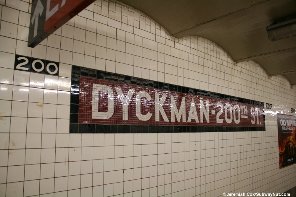
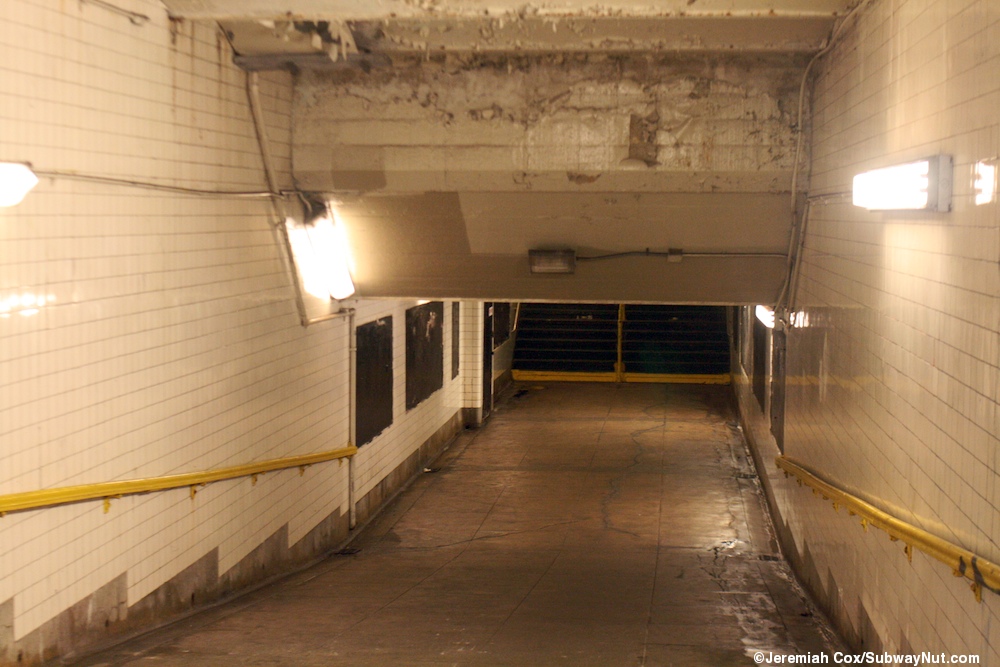
Both platform walls have no trim line, but there are mosaic name tablets reading "DYCKMAN–200TH ST." in white sans-serif lettering on a maroon background and black border. Small "200" tile captions in white numbering on a black background run along the walls between the name tablets. Yellow I-beam columns run along both platforms at regular intervals, alternating ones having the standard black station name plate in white lettering, reading "Dyckman Street".[10] A few column signs still read "200".[11] There is an underpass connecting the platforms.[12][13]
Exits[]
Each platform has one same-level fare control area and there is a crossunder inside fare control. The southbound platform has the full-time turnstile bank and token booth. There are three street stairs here, two of which are built inside buildings and go up to the northwest corner of Broadway and Dyckman Street. The other stair goes up to the southwest corner of Broadway and Riverside Drive on the northern end of Fort Tryon Park.[14]
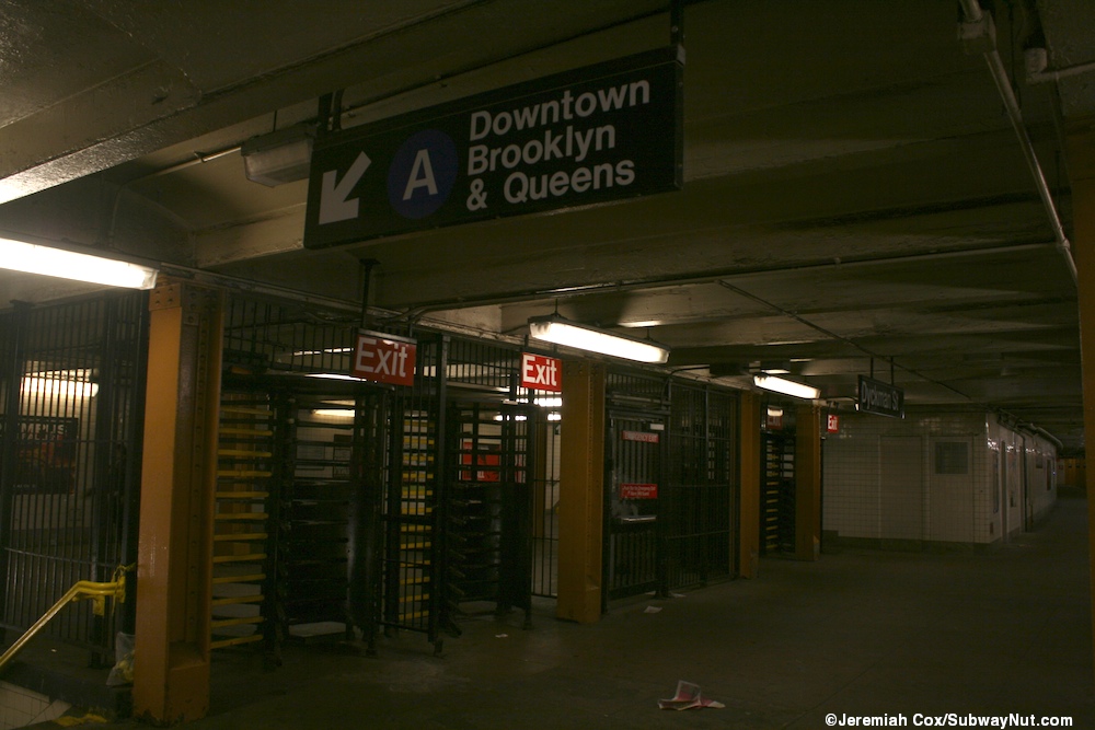
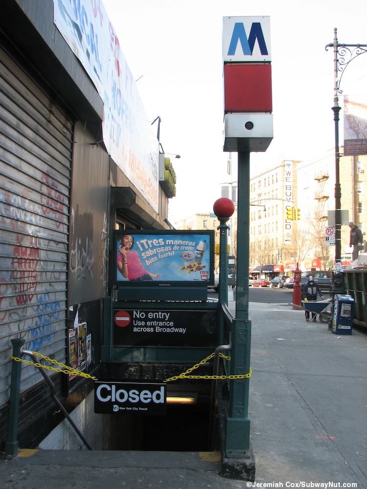
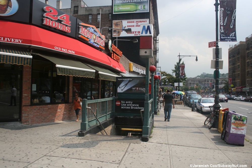
Since Inwood–207th Street is the next and last stop on the line, this station's fare control on the northbound platform is exit only, containing just full height turnstiles and four staircases, two of which go up to the northeast corner of Broadway and Dyckman Street and the other two to the southeast corner.[14][15][16]
Nearby points of interest[]
- Dyckman Farmhouse Museum[14]
- Fort Tryon Park[14]
- Inwood Hill Park[14]
References[]
- ^ "Glossary". Second Avenue Subway Supplemental Draft Environmental Impact Statement (SDEIS) (PDF). Vol. 1. Metropolitan Transportation Authority. March 4, 2003. pp. 1–2. Archived from the original (PDF) on February 26, 2021. Retrieved January 1, 2021.
- ^ "List of the 28 Stations on the New 8th Av. Line". The New York Times. September 10, 1932. p. 6. ISSN 0362-4331. Retrieved April 21, 2020.
- ^ "Station Developers' Information". Metropolitan Transportation Authority. Retrieved June 13, 2017.
- ^ "Facts and Figures: Annual Subway Ridership 2014–2019". Metropolitan Transportation Authority. 2020. Retrieved May 26, 2020.
- ^ a b "Facts and Figures: Annual Subway Ridership 2014–2019". Metropolitan Transportation Authority. 2020. Retrieved May 26, 2020.
- ^ Crowell, Paul (September 10, 1932). "Gay Midnight Crowd Rides First Trains In The New Subway: Throngs at Station an Hour Before Time, Rush Turnstiles When Chains are Dropped" (PDF). The New York Times. Retrieved November 8, 2015.
- ^ Review of the A and C Lines (PDF) (Report). Metropolitan Transportation Authority. December 11, 2015. Archived from the original (PDF) on February 3, 2020. Retrieved January 19, 2016.
- ^ Dougherty, Peter (2006) [2002]. Tracks of the New York City Subway 2006 (3rd ed.). Dougherty. OCLC 49777633 – via Google Books.
- ^ "A Subway Timetable, Effective November 8, 2020" (PDF). Metropolitan Transportation Authority. Retrieved December 9, 2020.
- ^ Cox, Jeremiah (March 7, 2013). "A name tablet". subwaynut.com. Retrieved March 21, 2018.
- ^ Barnes, John (June 15, 2009). "(One of?) the last 200 St. signs at Dyckman Street (Line A)- most have been removed". nycsubway.org. Retrieved March 21, 2018.
- ^ Cox, Jeremiah (August 15, 2008). "The underpass that has seen better days". subwaynut.com. Retrieved March 21, 2018.
- ^ Cox, Jeremiah (March 7, 2013). "The underpass and High Exit turnstiles from the uptown platform". subwaynut.com. Retrieved March 21, 2018.
- ^ a b c d e "MTA Neighborhood Maps: Inwood" (PDF). Metropolitan Transportation Authority. 2015. Retrieved July 29, 2016.
- ^ Cox, Jeremiah (December 21, 2005). "The Exit Only No Entry Staircase also has a chain and closed sign during the transit strike to try and prevent passengers from going down". subwaynut.com. Retrieved March 21, 2018.
- ^ Cox, Jeremiah (August 15, 2008). "The two exit only streetstairs (with red square Ms and normal globes) from the uptown platform". subwaynut.com. Retrieved March 21, 2018.
External links[]
| Wikimedia Commons has media related to Dyckman Street (IND Eighth Avenue Line). |
- nycsubway.org – IND 8th Avenue: Dyckman Street/200th Street
- Station Reporter — A Rockaway
- Station Reporter — A Lefferts
- The Subway Nut — Dyckman Street (A)
- Storefront entrance to Dyckman Street from Google Maps Street View
- Broadway and Riverside Drive entrance from Google Maps Street View
- Platform from Google Maps Street View
| Eighth Ave. Line |
|
|---|---|
| |
- IND Eighth Avenue Line stations
- New York City Subway stations in Manhattan
- New York City Subway stations located underground
- Railway stations in the United States opened in 1932
- 1932 establishments in New York City
- Broadway (Manhattan)
- Inwood, Manhattan
- U.S. Route 9