Beach 90th Street station
Beach 90 Street | |||||||||||||||||||||||||||||||||||||||||||||||||||||||||||||||||||||||||||||||||||||||||||
|---|---|---|---|---|---|---|---|---|---|---|---|---|---|---|---|---|---|---|---|---|---|---|---|---|---|---|---|---|---|---|---|---|---|---|---|---|---|---|---|---|---|---|---|---|---|---|---|---|---|---|---|---|---|---|---|---|---|---|---|---|---|---|---|---|---|---|---|---|---|---|---|---|---|---|---|---|---|---|---|---|---|---|---|---|---|---|---|---|---|---|---|
 Artwork on the Rockaway Park-bound platform | |||||||||||||||||||||||||||||||||||||||||||||||||||||||||||||||||||||||||||||||||||||||||||
| Station statistics | |||||||||||||||||||||||||||||||||||||||||||||||||||||||||||||||||||||||||||||||||||||||||||
| Address | Beach 90th Street & Rockaway Freeway Queens, NY 11693 | ||||||||||||||||||||||||||||||||||||||||||||||||||||||||||||||||||||||||||||||||||||||||||
| Borough | Queens | ||||||||||||||||||||||||||||||||||||||||||||||||||||||||||||||||||||||||||||||||||||||||||
| Locale | Rockaway Beach | ||||||||||||||||||||||||||||||||||||||||||||||||||||||||||||||||||||||||||||||||||||||||||
| Coordinates | 40°35′17″N 73°48′49″W / 40.588095°N 73.813499°WCoordinates: 40°35′17″N 73°48′49″W / 40.588095°N 73.813499°W | ||||||||||||||||||||||||||||||||||||||||||||||||||||||||||||||||||||||||||||||||||||||||||
| Division | B (IND, formerly LIRR Rockaway Beach Branch)[1] | ||||||||||||||||||||||||||||||||||||||||||||||||||||||||||||||||||||||||||||||||||||||||||
| Line | IND Rockaway Line | ||||||||||||||||||||||||||||||||||||||||||||||||||||||||||||||||||||||||||||||||||||||||||
| Services | A S | ||||||||||||||||||||||||||||||||||||||||||||||||||||||||||||||||||||||||||||||||||||||||||
| Transit | |||||||||||||||||||||||||||||||||||||||||||||||||||||||||||||||||||||||||||||||||||||||||||
| Structure | Elevated | ||||||||||||||||||||||||||||||||||||||||||||||||||||||||||||||||||||||||||||||||||||||||||
| Platforms | 2 side platforms | ||||||||||||||||||||||||||||||||||||||||||||||||||||||||||||||||||||||||||||||||||||||||||
| Tracks | 2 | ||||||||||||||||||||||||||||||||||||||||||||||||||||||||||||||||||||||||||||||||||||||||||
| Other information | |||||||||||||||||||||||||||||||||||||||||||||||||||||||||||||||||||||||||||||||||||||||||||
| Opened | June 1880 (LIRR station) | ||||||||||||||||||||||||||||||||||||||||||||||||||||||||||||||||||||||||||||||||||||||||||
| Rebuilt | June 28, 1956 (as a Subway station) | ||||||||||||||||||||||||||||||||||||||||||||||||||||||||||||||||||||||||||||||||||||||||||
| Station code | 200[2] | ||||||||||||||||||||||||||||||||||||||||||||||||||||||||||||||||||||||||||||||||||||||||||
| Opposite- direction transfer | Yes | ||||||||||||||||||||||||||||||||||||||||||||||||||||||||||||||||||||||||||||||||||||||||||
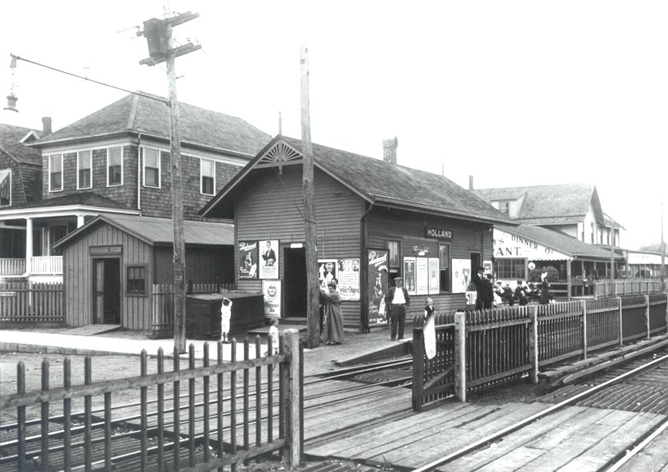
| Former/other names | Beach 90th Street–Holland | ||||||||||||||||||||||||||||||||||||||||||||||||||||||||||||||||||||||||||||||||||||||||||
| Traffic | |||||||||||||||||||||||||||||||||||||||||||||||||||||||||||||||||||||||||||||||||||||||||||
| 2019 | 348,771[4] | ||||||||||||||||||||||||||||||||||||||||||||||||||||||||||||||||||||||||||||||||||||||||||
| Rank | 416 out of 424[4] | ||||||||||||||||||||||||||||||||||||||||||||||||||||||||||||||||||||||||||||||||||||||||||
| Station succession | |||||||||||||||||||||||||||||||||||||||||||||||||||||||||||||||||||||||||||||||||||||||||||
| Next east | Broad Channel: A Beach 67th Street: no regular service | ||||||||||||||||||||||||||||||||||||||||||||||||||||||||||||||||||||||||||||||||||||||||||
| Next west | Beach 98th Street: A | ||||||||||||||||||||||||||||||||||||||||||||||||||||||||||||||||||||||||||||||||||||||||||
| |||||||||||||||||||||||||||||||||||||||||||||||||||||||||||||||||||||||||||||||||||||||||||
| |||||||||||||||||||||||||||||||||||||||||||||||||||||||||||||||||||||||||||||||||||||||||||
| |||||||||||||||||||||||||||||||||||||||||||||||||||||||||||||||||||||||||||||||||||||||||||
| |||||||||||||||||||||||||||||||||||||||||||||||||||||||||||||||||||||||||||||||||||||||||||
| |||||||||||||||||||||||||||||||||||||||||||||||||||||||||||||||||||||||||||||||||||||||||||


Beach 90th Street, signed as Beach 90th Street–Holland, is a station on the IND Rockaway Line of the New York City Subway. It is served by the Rockaway Park Shuttle at all times and ten daily rush-hour only A trains.
History[]
The "Holland" designation refers to Michael P. Holland, one of the early developers of the area in which the station was located. It was originally built by the Long Island Rail Road at Holland Avenue and Beach 92nd Street between May and June 1880 along the Rockaway Beach Branch for the nearby Holland Hotel, and was also a trolley stop of the Ocean Electric Railway. It was rebuilt in 1899, and again in 1914 with a baggage storage facility. Like much of the Rockaway Beach Branch and part of the former Far Rockaway Branch, it was closed in 1941 and rebuilt as an elevated station in 1942, only to be purchased by the New York City Transit Authority on October 3, 1955 and reopened as a subway station on June 28, 1956.
After Hurricane Sandy hit and destroyed the long stretch of the IND Rockaway Line, this was a terminal of the temporary H shuttle until May 30, 2013, when the A train and the Rockaway Park Shuttle were restored to the Rockaways. H trains terminated on the northbound track, because the Rockaway Park Shuttle was not in operation and A service was cut to Howard Beach–JFK Airport.
Station layout[]
| P Platform level |
Side platform | |
| Southbound | ← ← | |
| Northbound | (No service: Beach 67th Street) | |
| Side platform | ||
| M | Mezzanine | Fare control, station agent, MetroCard vending machines |
| G | Street level | Entrances/exits |
The station is built on a concrete viaduct. There are two tracks and two side platforms. New lights were installed in 2010.[5]
Exits[]
There is a crossunder to the tiled mezzanine. Outside of fare control, there are stairs to either eastern corner of Rockaway Freeway and Beach 90th Street. The southbound side had an additional exit on the south end, which has been removed.[6]
References[]
- ^ "Glossary". Second Avenue Subway Supplemental Draft Environmental Impact Statement (SDEIS) (PDF). 1. Metropolitan Transportation Authority. March 4, 2003. pp. 1–2. Archived from the original (PDF) on February 26, 2021. Retrieved January 1, 2021.
- ^ "Station Developers' Information". Metropolitan Transportation Authority. Retrieved June 13, 2017.
- ^ "Facts and Figures: Annual Subway Ridership 2014–2019". Metropolitan Transportation Authority. 2020. Retrieved May 26, 2020.
- ^ a b "Facts and Figures: Annual Subway Ridership 2014–2019". Metropolitan Transportation Authority. 2020. Retrieved May 26, 2020.
- ^ Two Rockaway Stations Re-Open Today (MTA Press Release; December 22, 2010)
- ^ "MTA Neighborhood Maps: The Rockaways" (PDF). mta.info. Metropolitan Transportation Authority. 2015. Retrieved July 6, 2015.
External links[]
 Media related to Beach 90th Street station at Wikimedia Commons
- nycsubway.org – IND Rockaway: Beach 90th Street/Holland
- Station Reporter — Rockaway Park Shuttle
- 1905 Image of Holland Station (Arrt's Arrchives)
- The Subway Nut — Beach 90th Street – Holland Pictures Archived 2017-06-15 at the Wayback Machine
- Beach 90 Street entrance from Google Maps Street View
- Platform level from Google Maps Street View
| Rockaway Line | |||||
|---|---|---|---|---|---|
| |||||
- IND Rockaway Line stations
- New York City Subway stations in Queens, New York
- New York City Subway stations located aboveground
- Railway stations in the United States opened in 1956
- 1956 establishments in New York City